

| Citation: |
LI Caihong, GUO Changbao, ZHANG Guangze, WU Ruian, ZHANG Xujiao, YANG Zhihua, LIN Zhiheng, ZHANG Yiying. A landslide volume calculation method based on LiDAR topography and slip surface reconstruction: A case study of Deda ancient landslide in Batang County of Sichuan Province[J]. Geological Bulletin of China, 2021, 40(12): 2015-2023.

|
A landslide volume calculation method based on LiDAR topography and slip surface reconstruction: A case study of Deda ancient landslide in Batang County of Sichuan Province
-
Abstract
Because of its suddenly occurrence and rapid movement, the landslide could do great harm to the society and human life. Because the damage caused by landslide increases with the increase of landslide scale, the accurate calculation of landslide volume is extremely important for the disaster prevention and control projects, and the disaster prevention and mitigation risk evaluation. At present, the commonly used methods for landslide volume calculation mainly include field measurement method, geometric method, numerical simulation method, and DEM method, etc., but there are some certain limitations and poor accuracy of landslide volume calculation results in some of those methods. Therefore, a landslide volume calculation method was proposed, which is based on the high-precision LiDAR terrain and sliding surface reconstruction and named LS-Drill_Volume. The Deda ancient landslide, distributed in Batang County of Sichuan Province, was taken as an example for the LS-Drill_Volume study. The airborne LiDAR scanning method was used to obtain the topographic data of Deda ancient landslide, the landslide boundary points and drill data were interpolated by Kriging interpolation method, and then the sliding surface was reconstructed. Based on the obtained the elevation of the sliding surface, by means of ArcGIS software, the landslide volume was finally calculated by filling and excavation. The calculating results show that the volume of Deda ancient landslide is 1259×104 m3, of which the volume of Deda Ⅰ landslide section is 613×104 m3, and the volume of landslide Ⅱ section is 646×104 m3. Compared with the field measurement method, the volume calculation accuracy is improved by 20.8%, 21.4% and 20.2%, respectively. Compared with the existing volume measurement methods, this method can provide more accurate volume of landslide, so as to provide more reliable basis for landslide evaluation and prevention engineering.
-
Keywords:
- landslide volume /
- sliding surface /
- LiDAR /
- drill /
- Deda ancient landslide
-

-
References
[1] 黄润秋. 20世纪以来中国的大型滑坡及其发生机制[J]. 岩石力学与工程学报, 2007, 26(3): 433-451. doi: 10.3321/j.issn:1000-6915.2007.03.001 [2] 王治华. 滑坡遥感调查、监测与评估[J]. 国土资源遥感, 2007, (1): 10-15, 23, 103. doi: 10.3969/j.issn.1001-070X.2007.01.002 [3] 郭长宝, 张永双, 蒋良文, 等. 川藏铁路沿线及邻区环境工程地质问题概论[J]. 现代地质, 2017, 31(5): 877-899. doi: 10.3969/j.issn.1000-8527.2017.05.001 [4] 孙小平, 曾鹏, 张天龙, 等. 滑坡运动距离超越概率评价及危险性区划[J]. 地质通报, 2021, 40(9): 1560-1569. [5] 张小咏, 陈正超, 赵海涛. 一种基于遥感影像和DEM的滑坡体体积快速计算方法[J]. 应用基础与工程科学学报, 2013, 21(5): 938-945. doi: 10.3969/j.issn.1005-0930.2013.05.014 [6] 许强, 李为乐, 董秀军, 等. 四川茂县叠溪镇新磨村滑坡特征与成因机制初步研究[J]. 岩石力学与工程学报, 2017, 36(11): 2612-2628. [7] Barla G, Paronuzzi P. The 1963 Vajont Landslide: 50th Anniversary[J]. Rock Mechanics and Rock Engineering, 2013, 46(6): 1267-1270. doi: 10.1007/s00603-013-0483-7 [8] 钟立勋. 意大利瓦依昂水库滑坡事件的启示[J]. 中国地质灾害与防治学报, 1994, (2): 77-84. [9] 赵志明, 潘岳, 陈理. 四川茂县新磨村滑坡高速启动机理研究[J/OL]. 工程地质学报: 1-10[2021-08-19]. https://doi.org/10.13544/j.cnki.jeg.2020-241. [10] 韩建楠. 基于重构滑动面的滑坡体积的测算[D]. 长安大学硕士学位论文, 2018. [11] Cha D, Hwang J, Choi B. Landslides detection and volume estimation in Jinbu area of Korea[J]. Forest Science and Technology, 2018, 14(2): 61-65. doi: 10.1080/21580103.2018.1446367 [12] 熊道锟, 胡济珍. 一种计算滑坡体积的新方法[J]. 水文地质工程地质, 1990, (2): 51-54, 50. [13] 王湘桂, 吕玲, 王浩. 平行断面法在滑坡体积计算中的应用[J]. 资源环境与工程, 2012, 26: 107-108. doi: 10.3969/j.issn.1671-1211.2012.z1.029 [14] 周婷, 葛云峰, 郑淼, 等. 火星水手谷滑坡体体积的计算方法研究[J]. 安全与环境工程, 2017, 24(4): 34-42. [15] Marchesini I, Cencetti C, Rosa P. A preliminary method for the evaluation of the landslides volume at a regional scale[J]. GeoInformatica, 2009, 13(3): 277-289. doi: 10.1007/s10707-008-0060-5 [16] Murty T S. Tsunami Wave Height Dependence on Landslide Volume[J]. Pure and Applied Geophysics, 2003, 160(10/11): 2147-2153. [17] Nikolaeva E, Walter T R, Shirzaei M, et al. Landslide observation and volume estimation in central Georgia based on L-band InSAR[J]. Natural Hazards and Earth System Science, 2014, 14(3): 675-688. doi: 10.5194/nhess-14-675-2014 [18] 王治华, 徐起德, 徐斌. 岩门村滑坡高分辨率遥感调查与机制分析[J]. 岩石力学与工程学报, 2009, 28(9): 1810-1818. doi: 10.3321/j.issn:1000-6915.2009.09.011 [19] 殷跃平, 成余粮, 王军, 等. 汶川地震触发大光包巨型滑坡遥感研究[J]. 工程地质学报, 2011, 19(5): 674-684. doi: 10.3969/j.issn.1004-9665.2011.05.007 [20] Rahman A M, Hiroyuki M. Volumetric Analysis of the Landslide in Abe Barek, Afghanistan Based on Nonlinear Mapping of Stereo Satellite Imagery-Derived DEMs[J]. Remote Sensing, 2021, 13(3): 1-22. [21] 曹入文, 周训, 陈柄桦, 等. 四川巴塘县茶洛地区温泉及间歇喷泉水化学特征和成因分析[J]. 地学前缘, 2021, 28(4): 361-372. [22] 白永健, 李明辉, 王东辉, 等. 金沙江中游巴塘县地质灾害发育特征及成灾规律[J]. 中国地质灾害与防治学报, 2014, 25(2): 103-109. [23] 吴瑞安, 倪嘉伟, 郭长宝等. 川西巴塘断裂带黄草坪滑坡形成机制[J]. 地质通报, 2021, 40(12): 1992-2001. [24] 刘妍. 基于MicroStation的机载激光雷达数据处理应用研究[D]. 长安大学硕士学位论文, 2011. [25] 赵秀臣. 基于无人机低空遥感和深度学习的DEM生产技术[D]. 西安电子科技大学硕士学位论文, 2019. [26] 吴小芳, 杜清运, 徐智勇, 等. 复杂线状符号的设计及优化算法研究[J]. 武汉大学学报(信息科学版), 2006, (7): 632-635. [27] 靳国栋, 刘衍聪, 牛文杰. 距离加权反比插值法和克里金插值法的比较[J]. 长春工业大学学报(自然科学版), 2003(3): 53-57. doi: 10.3969/j.issn.1674-1374-B.2003.03.017 [28] 李俊晓, 李朝奎, 殷智慧. 基于ArcGIS的克里金插值方法及其应用[J]. 测绘通报, 2013, (9): 87-90, 97. [29] 刘世伟, 吴锦奎, 张文春, 等. 基于克里金插值估算区域降水量的抽样方法对比分析——以甘肃省为例[J]. 冰川冻土, 2015, 37(3): 650-657. [30] 张建成, 葛亮, 王亮. 利用ArcGIS进行土方挖填方量计算的原理与实践[J]. 中国水土保持, 2016, (7): 65-67. doi: 10.3969/j.issn.1000-0941.2016.07.025 -
Access History

Figures(9)
Tables(3)

Export File
Citation
LI Caihong, GUO Changbao, ZHANG Guangze, WU Ruian, ZHANG Xujiao, YANG Zhihua, LIN Zhiheng, ZHANG Yiying. A landslide volume calculation method based on LiDAR topography and slip surface reconstruction: A case study of Deda ancient landslide in Batang County of Sichuan Province[J]. Geological Bulletin of China, 2021, 40(12): 2015-2023.
Format
Content
 DownLoad:

-
Figure 1.
Location of the Deda landslide area in Batang County, Sichuan Province
-
Figure 2.
Geology plane of Deda landslide in Batang County
-
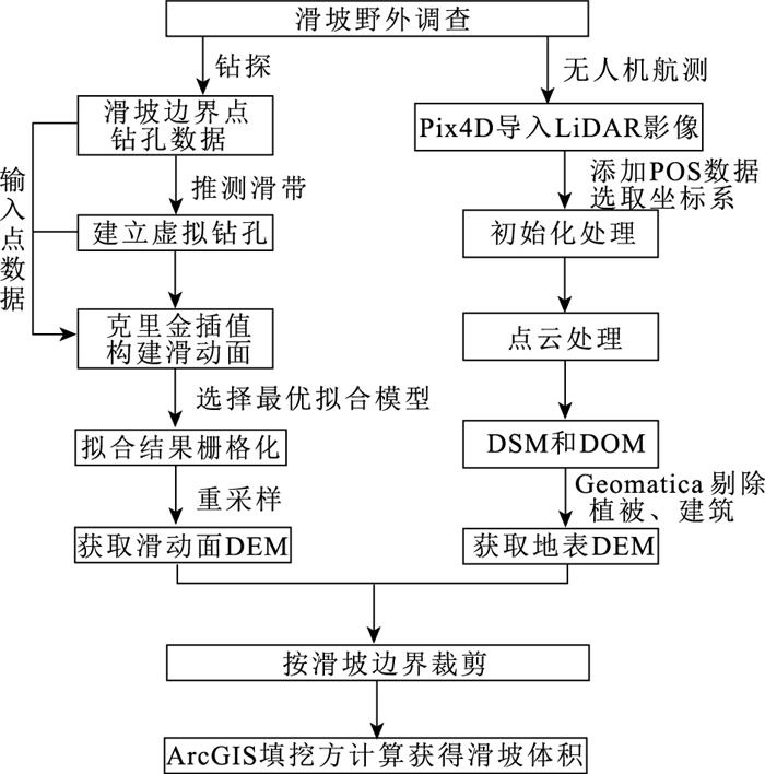
Figure 3.
Flow chart of landslide volume calculation method
-
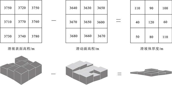
Figure 4.
The calculation principle of fill and excavation volume
-
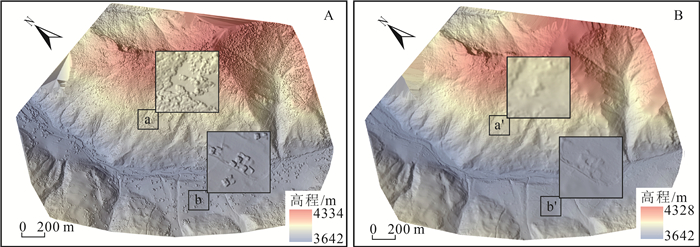
Figure 5.
Comparison of DSM(A) and DEM(B) treatment effects of Deda ancient landslide
-
Figure 6.
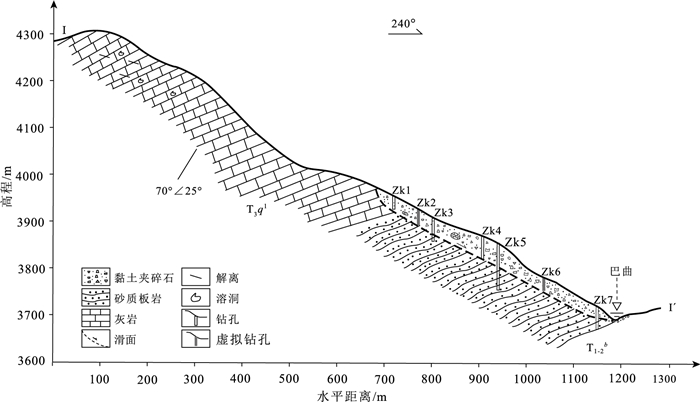
Engineering geological profile(Ⅰ-Ⅰ')of Deda ancient landslide
-
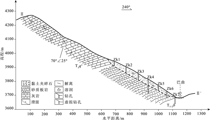
Figure 7.
Engineering geological profile(Ⅱ-Ⅱ')of Deda ancient landslide
-
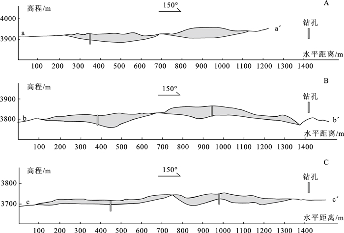
Figure 8.
Cross section of Deda ancient landslide
-
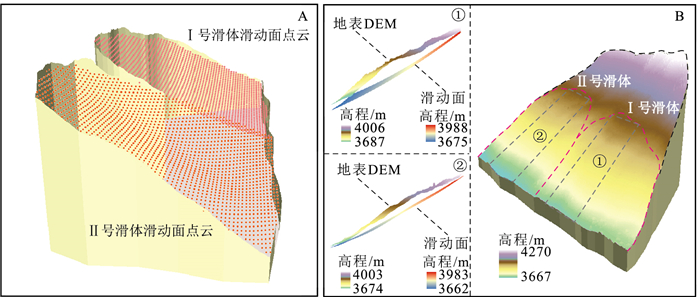
Figure 9.
Sliding surface fitting results of the Deda ancient landslide