
| Citation: |
ZHANG Jiajia, TIAN You, CHEN Long, LI Yuanling, GAO Bo, LI Hongliang. Development and formation mechanism of landslides along Changdu section of Lancang River[J]. Geological Bulletin of China, 2021, 40(12): 2024-2033.

|
Development and formation mechanism of landslides along Changdu section of Lancang River
-
Abstract
The most serious geo-hazards always occur in mountainous areas and plateaus in China, and a series of serious geo-hazards have occurred along the major rivers in eastern Tibet Plateau. Based on the previous research of InSAR remote sensing interpretation, through detailed field investigation, 75 landslides were determined along the Changdu section of Lancang River. Based on the analysis of the development characteristics and main influencing factors of landslides in detail, the formation mechanism of 6 types of typical landslides was summarized. The result shows that among the landslides along the Lancang River, the creep landslide in the accumulation layer is the most developed, and the river-cut slope caused by the rise and fall of the water level is the main influencing factor of the soil landslides along the river.High-location landslides near the river often slip directly into the valley, showing the high location but not remote characteristics. The two most developed types of slope structures in rock landslides are reverse and dip slopes, which are directly related to the bedding developed in the weak rock mass of sand and mudstone and the main joints perpendicular to the bedding. More than 85% landslides occur in the soft-little soft sedimentary rock association, indicating that the rock strength affects the development of landslides to a certain extent. The strong weathering zone on the surface of the slope and the accumulation body of the ancient landslide provide the material foundation for the landslides in accumulation layer, and these landslides are mostly characterized by creep sliding and multi-stage sliding. The Kagong-Yanjing active fault controls the spatial distribution of landslides. The faults control the landslide boundary and the fracture zone directly becomes the slide body. The results can provide reference and support for slope hazard management during the railway construction.
-
Keywords:
- development characteristics /
- formation mechanism /
- landslides /
- Lancang River
-

-
References
[1] Glade T. Establishing the frequency and magnitude of landslide-triggering rainstorm events in New Zealand[J]. Environ. Geol., 1998, 35(2/3): 160-174. [2] Wallemacq P, Below R, McLean D. Economic losses, poverty and disasters 1998-2017[M]. United Nations Office for disaster risk reduction (UNDRR) and Centre for Research on the Epidemiology of Disasters (CRED) publications, 2018. [3] Turner A K. Social and environmental impacts of landslides[J]. Innov. Infrastruct. Solut., 2018, 3(1). [4] Liu W, Yan S X, He S M. Landslide damage incurred to buildings: A case study of Shenzhen landslide[J]. Engineering Geology, 2018, 247: 69-83. doi: 10.1016/j.enggeo.2018.10.025 [5] Çelik S, Ozyazıcıoglu M, Sahin R, et al. The destruction of Erzurum ski-jumping complex by a landslide: evaluation of an engineering design failure[J]. Nat Hazards, 2021, 107: 475-496. doi: 10.1007/s11069-021-04591-2 [6] Shi P. Natural Disasters in China[M]. Springer, Berlin, Heidelberg, 2016. [7] Tomáš P. Landslides and Quaternary climate changes-The state of the art[J]. Earth-Science Reviews, 2019, 196: 102871. doi: 10.1016/j.earscirev.2019.05.015 [8] Zhang Y, Zhao X, Lan H, et al. A pleistocene landslidedammed lake, Jinsha River, Yunnan, China[J]. Quaternary International, 2011, 233(1): 72-80. doi: 10.1016/j.quaint.2010.10.020 [9] Chen J, Dai F, Lv T, et al. Holocene landslide-dammed lake deposits in the upper Jinsha River, SE Tibetan Plateau and their ages[J]. Quaternary International, 2013, 298: 107-123. doi: 10.1016/j.quaint.2012.09.018 [10] Wang P, Chen J, Dai F, et al. Chronology of relict lake deposits around the Suwalong paleo landslide in the upper Jinsha River, SE Tibetan Plateau: Implications to Holocene tectonic perturbations[J]. Geomorphology, 2017, 217: 193-203. [11] Dai F C, Deng J H. Development characteristics of landslide hazards in Three-rivers basin of southeast Tibetan Plateau[J]. Advanced Engineering Sciences, 2020, 52(5): 3-15. [12] Lv L Q, Xu M Z, Wang Z Y, et al. Impact of densely distributed debris flow dams on river morphology of the Grand Canyon of the Nu River (upper Salween River) at the east margin of the Tibetan Plateau[J]. Landslides, 2021, 18(5): 979-991. [13] Hu M M, Wu Z H, Reicherter K, et al. A Historical Earthquake-Induced Landslide Damming Event at the Qiaojia Reach of the Jinsha River, SE Tibetan Plateau: Implication for the Seismic Hazard of the Xiaojiang Fault[J]. Frontiers in Earth Science, 2021, (9): 1-25. [14] Xiong Z Q, Feng G C, Feng Z X, et al. Pre-and post-failure spatial-temporal deformation pattern of the Baige landslide retrieved from multiple radar and optical satellite images[J]. Engineering Geology, 2020, 279(11): 105880. [15] An H C, Ouyang C J, Zhou S. Dynamic process analysis of the Baige landslide by the combination of DEM and long-period seismic waves[J]. Landslides, 2021, 3: 1625-1639. doi: 10.1007/s10346-020-01595-0 [16] Lu C F, Cai C X. Challenges and Countermeasures for Construction Safety during the Sichuan-Tibet Railway Project[J]. Engineering, 2019, 5(5): 833-838. doi: 10.1016/j.eng.2019.06.007 [17] 郭长宝, 吴瑞安, 蒋良文, 等. 川藏铁路雅安-林芝段典型地质灾害与工程地质问题[J]. 现代地质, 2021, 35(1): 1-17. [18] 汤明高, 许强, 马和平, 等. 西藏昌都镇地质灾害发育特征及防治对策[J]. 中国地质灾害与防治学报, 2006, 17(4): 11-16. doi: 10.3969/j.issn.1003-8035.2006.04.003 [19] 苏鹏程, 韦方强. 澜沧江流域滑坡泥石流空间分布及危险性分区[J]. 资源科学, 2014, 36(2): 273-281. [20] 刘欢, 朱谷昌, 刘海利, 等. 基于RS和GIS的西藏昌都县地质灾害危险性评价[J]. 地质找矿论丛, 2011, 26(1): 102-107. [21] 张佳佳, 高波, 刘建康, 等. 基于SBAS-InSAR技术的川藏铁路澜沧江段滑坡隐患早期识别[J]. 现代地质, 2021, 35(1): 64-73. [22] 彭勇民. 昌都地区三叠纪层序地层与沉积盆地演化[D]. 成都理工学院博士学位论文, 1999. [23] Hooper A, Bekaert D, Spaans K, et al. Recent advances in SAR interferometry time series analysis for measuring crustal deformation[J]. Tectonophysics, 2012, 514/517: 1-13. doi: 10.1016/j.tecto.2011.10.013 [24] 蓝康文. 川藏铁路高山峡谷边坡卸荷带变形破坏模式及稳定性研究[D]. 西南交通大学硕士学位论文, 2018. [25] 邹俊. 高寒山区深切峡谷碎裂松动岩体发育特征及稳定性研究[D]. 成都理工大学硕士学位论文, 2016. [26] 程强, 寇小兵, 黄绍槟, 等. 中国红层的分布及地质环境特征[J]. 工程地质学报, 2004, 12(1): 34-41. doi: 10.3969/j.issn.1004-9665.2004.01.007 [27] 殷跃平, 胡瑞林. 三峡库区巴东组(T2b)紫红色泥岩工程地质特征研究[J]. 工程地质学报, 2004, 12(2): 124-136. doi: 10.3969/j.issn.1004-9665.2004.02.003 [28] 易劲松. 川东红层滑坡的形成条件与早期识别研究[D]. 成都理工大学硕士学位论文, 2015. [29] 胡泽铭. 四川红层地区缓倾角滑坡成因机理研究[D]. 成都理工大学硕士学位论文, 2015. [30] 李江, 许强, 王森, 等. 川东红层地区降雨入渗模式与岩质滑坡成因机制研究[J]. 岩石力学与工程学报, 2016, 35(A2): 4053-4062. [31] 张涛, 谢忠胜, 石胜伟, 等. 川东红层缓倾岩质滑坡的演化过程及其识别标志探讨[J]. 工程地质学报, 2017, 25(2): 496-503. [32] 张永双, 苏生瑞, 吴树仁, 等. 强震区断裂活动与大型滑坡关系研究[J]. 岩石力学与工程学报, 2011, 28(z2): 3503-3513. [33] 张佳佳, 陈龙, 王军朝, 等. 藏东南鲁朗-通麦崩塌滑坡孕灾地质背景特征研究[J]. 地质力学学报, 2018, 24(4): 474-481. [34] 戴福初, 邓建辉. 青藏高原东南三江流域滑坡灾害发育特征[J]. 工程科学与技术, 2020, 52(5): 3-15. ① 西藏自治区水利电力规划勘测设计研究院. 西藏昌都澜沧江河道治理工程(西藏)水文报告. 西藏自治区水利电力规划勘测设计研究院, 2014. -
Access History

Figures(11)
Tables(2)

Export File
Citation
ZHANG Jiajia, TIAN You, CHEN Long, LI Yuanling, GAO Bo, LI Hongliang. Development and formation mechanism of landslides along Changdu section of Lancang River[J]. Geological Bulletin of China, 2021, 40(12): 2024-2033.
Format
Content
 DownLoad:

-
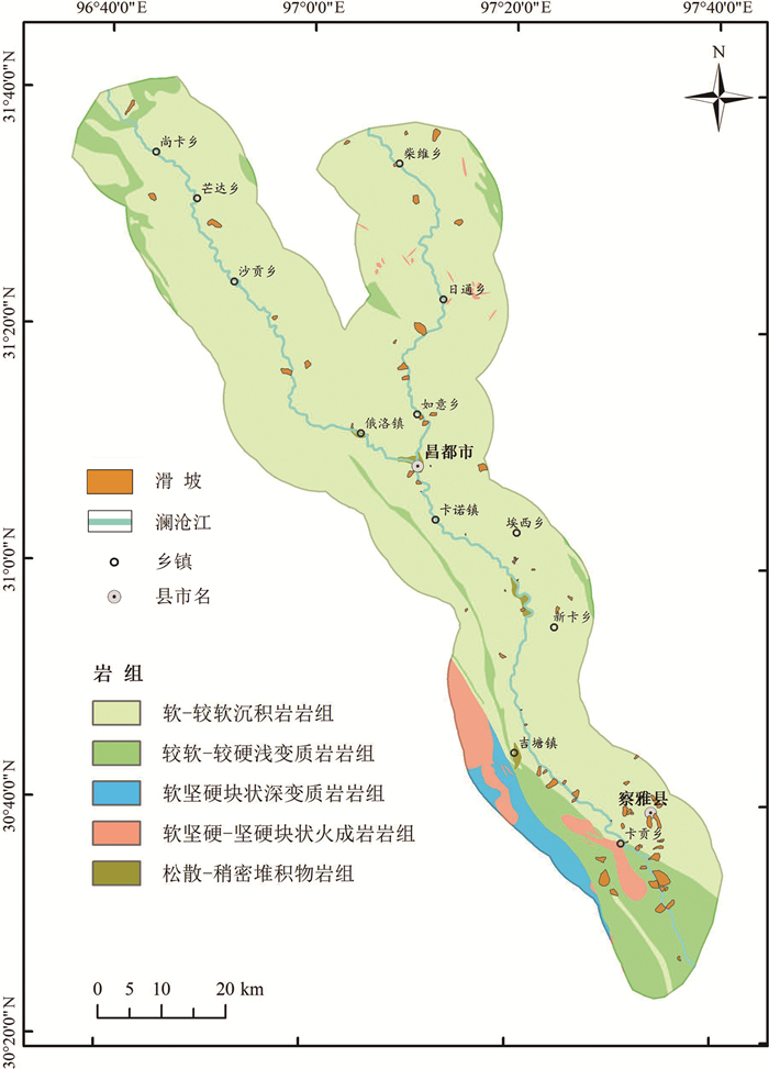
Figure 1.
Location of Changdu section of Lancang River
-
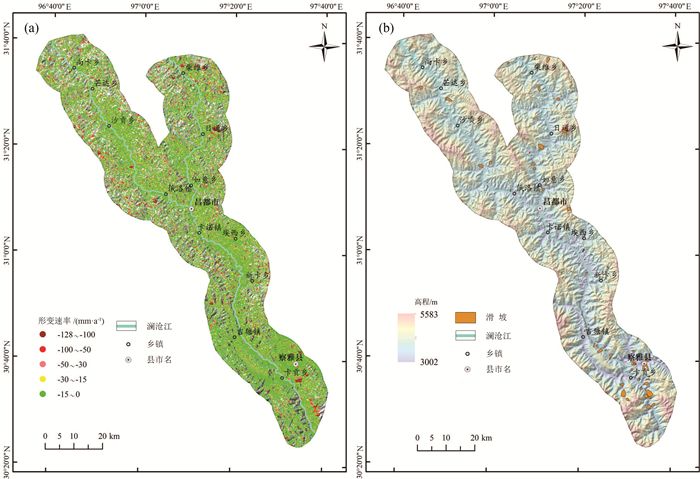
Figure 2.
Deformation rate of slop(a)and distribution of landslides(b)in Changdu section of Lancang River
-
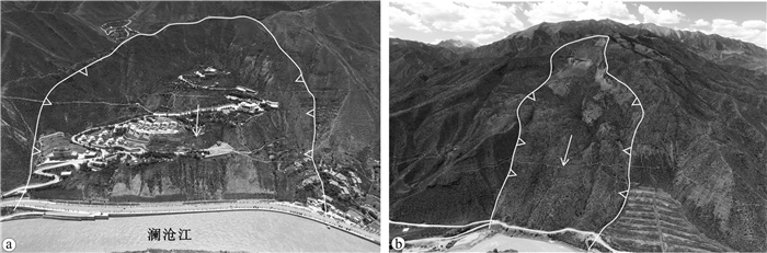
Figure 3.
Typical creeping and high-locality landslide along Lancang River
-
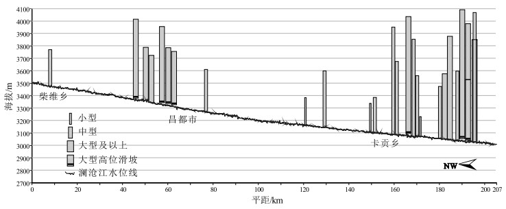
Figure 4.
Relationship between landslides and water level of Lancang River
-
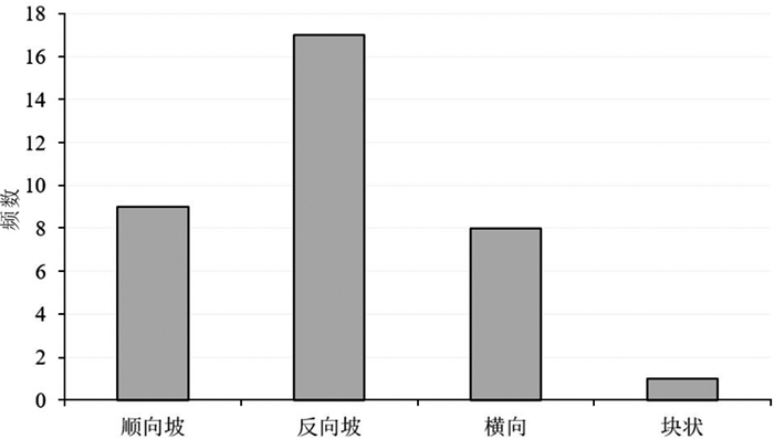
Figure 5.
Number of landslides in different slop structure
-
Figure 6.
Full view of typical landslides with reverse and forward slopes by UAV
-
Figure 7.
Development of landslides in different rock association along Lancang River
-
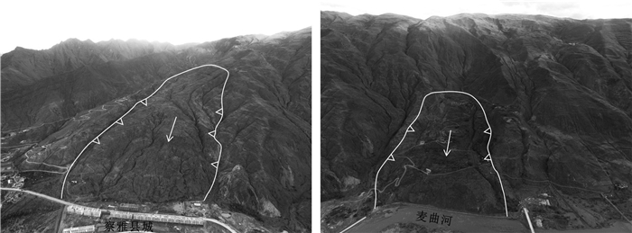
Figure 8.
Full view of typical ancient landslides along Maiqu River, a tributary of Lancang River
-
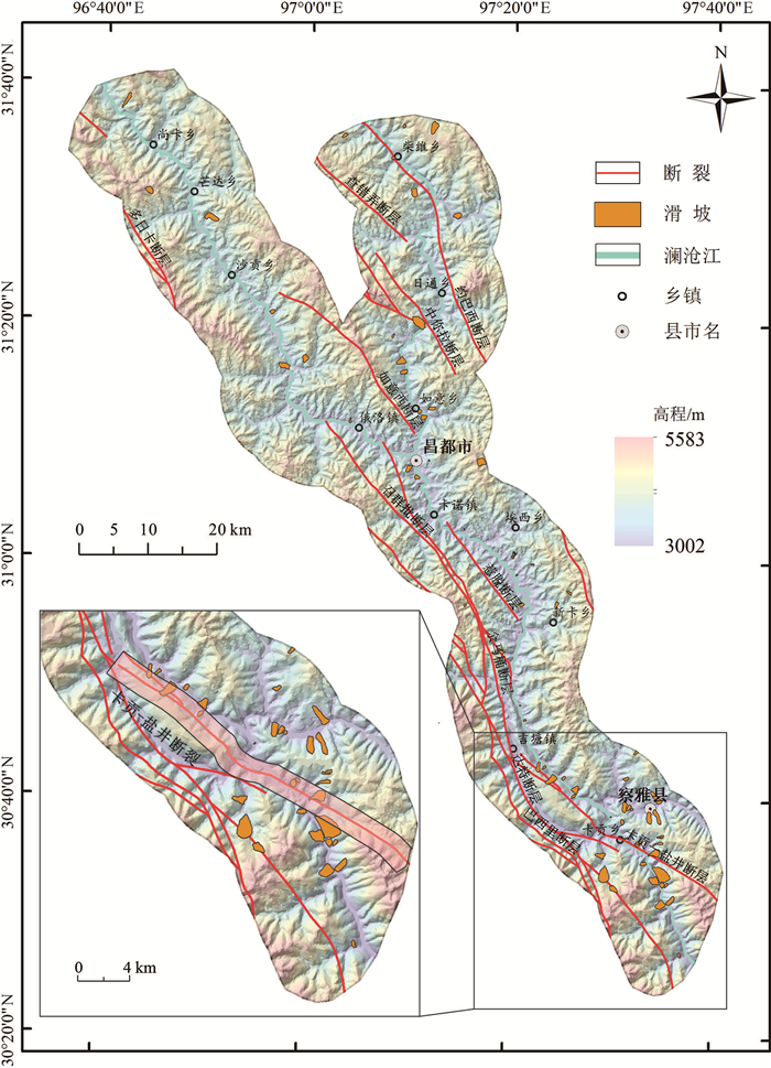
Figure 9.
Distribution of landslides along typical faults in Lancang River
-
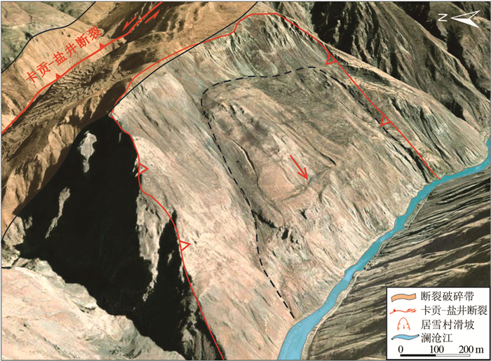
Figure 10.
Spatial relationship between Kagong-Yanjing fault and Juxue landslide
-
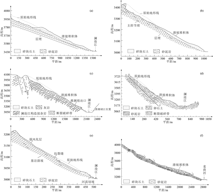
Figure 11.
Formation mechanism of typical landslides in the study area