
| Institute of Geomechanics, Chinese Academy of Geological Sciences | Host |
| Citation: |
ZHANG Nan, LIU Chang, LU Hong-yan. APPLICATION OF BEIDOU SATELLITE TECHNOLOGY TO FIELD GEOLOGICAL SURVEY IN THE NORTHEASTERN CHINA[J]. Journal of Geomechanics, 2012, 18(3): 264-269.

|
APPLICATION OF BEIDOU SATELLITE TECHNOLOGY TO FIELD GEOLOGICAL SURVEY IN THE NORTHEASTERN CHINA
-
Abstract
There are three main disadvantages of geological survey in the northeast China as below:firstly, It's very hard to communicate each other when the people worked in dispersed locations; secondly, high fluidity was difficult to manage and arrange; thirdly, it's very dangerous when entering unfamiliar areas. Beidou satellite technology made all these problems solved in a certain extent. It's not only making people communicate each other by text message without mobile phone, but also can take interactive multi-route business strategy. The security warning plan database stored in the Beidou satellite service system can be targeted to the terminal area of security demands by pushing safety instructions and emergency disposal program. Workers through Beidou satellite module can get all the information, bulletin and messages timely they need in the area that communication signals do not cover. The application of this system effected very well in northeast China.
-

-
References
[1] 曾庆化, 刘建业, 胡倩倩, 等.北斗系统及GNSS多星座组合导航性能研究[J].全球定位系统, 2011, 36(1):53~57. ZENG Qing-hua, LIU Jian-ye, HU Qian-qian, et al. Research on Beidou and GNSS multi-constellation integrated navigation[J]. GNSS World of China, 2011, 36(1):53~57. [2] 吴才聪, 苏怀洪, 褚天行, 等.基于北斗的移动应急监控与指挥技术[J].数字通信世界, 2011, (12):60~63. doi: 10.3969/j.issn.1672-7274.2011.12.026 WU Cai-cong, SU Huai-hong, ZHU Tian-xing, et al. Mobile emergency monitoring and command technology based on Beidou satellite system[J]. Digital Communication World, 2011, (12):60~63. doi: 10.3969/j.issn.1672-7274.2011.12.026 [3] 陈俊, 张雷, 王远飞.基于北斗和GPS的森林防火人员调度指挥系统[J].软件, 2012, 33(2):27~30. CHEN Jun, ZHANG Lei, WANGYuan-fei. Forest fire patrol command system based on compass and GPS[J]. Computer Engineering & Software, 2012, 33(2):27~30. [4] 董晶晶, 王磊, 张婷.北斗在"物联网"时代应用的几点思考[J].数字通信世界, 2010, (12):56~57. doi: 10.3969/j.issn.1672-7274.2010.12.012 DONG Jing-jing, WANG Lei, ZHANG Ting. Some thoughts about the application of Beidou system in the era of Internet of Things[J].Digital Communication World, 2010, (12):56~57. doi: 10.3969/j.issn.1672-7274.2010.12.012 [5] 刘佳, 徐博, 雍少为.北斗系统在炮兵旅中的应用研究[J].舰船电子工程, 2010, 30(8):60~62. LIU Jia, XU Bo, YONGShao-wei. Research on the application of Beidou system in artillery brigade[J]. Ship Electronic Engineering, 2010, 30(8):60~62. [6] 沈鹏, 徐景硕, 张建忠.北斗导航系统及其在无人机上的应用[J].航空电子技术, 2007, 38(2):5~8. SHEN Peng, XUJing-shuo, ZHANG Jian-zhong. Beidou Navigation Positioning System and its application to unmanned aerial vehicle[J]. Avionics Technology, 2007, 38(2):5~8. [7] 王磊, 翟国君, 黄谟涛, 等.利用北斗多频观测进行舰船姿态测量[J].海洋测绘, 2007, 27(2):11~14. WANG Lei, ZHAIGuo-jun, HUANG Mo-tao, et al. The attitude measure of vessel using Beidou multi-frequency observation[J]. Hydrographic Surveying and Charting, 2007, 27(2):11~14. [8] 薛瑞, 周涛, 李小汝.基于北斗的灾害预警信息发布应用层FEC性能分析[J].北华航天工业学院学报, 2011, 21(3):12~14. XUE Rui, ZHOU Tao, LIXiao-ru. The analysis of application of packet level FEC to disinter warning distribution system based on COMPASS[J]. Journal of North China Institute of Aerospace Engineering, 2011, 21(3):12~14. [9] 王孝广, 陈伟, 刘建, 等.基于北斗/GPS/BGAN卫星技术的应急指挥监控系统[J].交通信息与安全, 2009, 27(2):127~130. WANG Xiao-guang, CHEN Wei, LIU Jian, et al. Emergency direction supervisory system based on Beidou/GPS/BGAN satellite technology[J]. Journal of Transport information and safety, 2009, 27(2):127~130. [10] 陈晓, 陈杨, 蒋宁.北斗/CDMA组合导航数据融合及其在军事物流中的应用研究[J].物流技术, 2008, 27(6):126~128. CHEN Xiao, CHEN Yang, JIANG Ning. Beidou/CDMA navigating and positioning data fusion and its application in military logistics[J]. Logistics Technology, 2008, 27(6):126~128. -
Access History
Figures(3)

Export File
Citation
ZHANG Nan, LIU Chang, LU Hong-yan. APPLICATION OF BEIDOU SATELLITE TECHNOLOGY TO FIELD GEOLOGICAL SURVEY IN THE NORTHEASTERN CHINA[J]. Journal of Geomechanics, 2012, 18(3): 264-269.
Format
Content
 DownLoad:
-
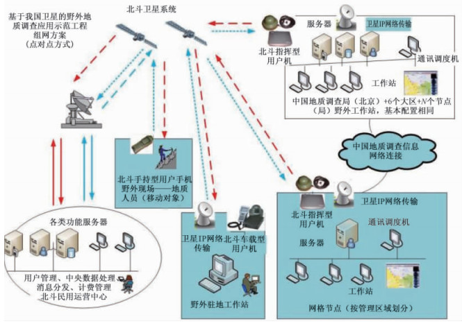
Figure 1.
The architecture diagram of Beidou navigation satellite system
-
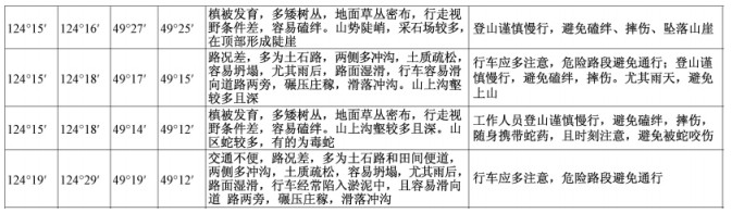
Figure 2.
Information from the security warning plan database
-
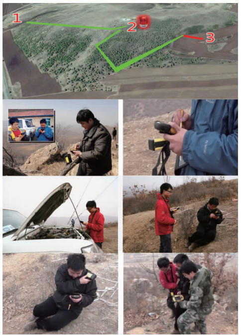
Figure 3.
Communication in the field emergency disposal and rescue in different weather