
| Institute of Geomechanics, Chinese Academy of Geological Sciences | Host |
| Citation: |
ZHAO Wen-ting, HU Dao-gong. APPLICATION OF BEIDOU SATELLITE POSITIONING SYSTEM IN GEOLOGICAL MAPPING IN EAST KUNLUN[J]. Journal of Geomechanics, 2012, 18(3): 254-263.

|
APPLICATION OF BEIDOU SATELLITE POSITIONING SYSTEM IN GEOLOGICAL MAPPING IN EAST KUNLUN
-
Abstract
According to the application of Beidou Satellite Terminal Positioning System that is tested in different latitudes, weather conditions, tectonic geomorphology and the conditions of moving in East Kunlun Mountain, application characteristics and inadequacy of this system in the field geological investigation are summarized and its development is also stated. The result showed that the satellite terminal positioning system had improved the efficiency, protected geological fieldworkers' safety, which played an important role in field operations management and emergency services. Currently the positioning accuracy is not just as one wish, for the positioning signal had been affected by tectonic geomorphology, weather and the way fieldworkers moved, and this is the key problems to be solved in the future.
-

-
References
[1] 唐金元, 于潞, 王思臣.北斗卫星导航定位系统应用现状分析[J].全球定位系统, 2008, 38(2):26~29. TANGJin-yuan, YU Lu, WANG Si-chen. Applying current situation analysis of Beidou Satellites Navigation Positioning System[J].Global Positioning System, 2008, 38(2):26~29. [2] 姚一飞, 王浩, 赵东发.北斗卫星导航定位系统综述[J].科技向导, 2011, (8):10, 35. YAO Yi-fei, WANG Hao, ZHAO Dong-fa. Overview of Beidou Satellite Navigation and Positioning System[J]. Technology Guide, 2011, (8):10, 35. [3] 王磊, 宋蕾.利用北斗短信功能实现海上测量信息的回传[J].海洋测绘, 2011, 31(3):25~27. WANG Lei, SONG Lei. Equipment status information returned using compass SMS[J]. Marine Surveying, 2011, 31(3):25~27. [4] 黄丽卿, 张杏谷, 郑佳春, 等.北斗终端数据处理与应用[J].集美大学学报:自然科学版, 2008, 14(3):24~27. HUANG Li-qing, ZHANG Xing-gu, ZHENG Jia-chun, et al. Study on the processing and using of the data from the 'Beidou' receiving terminal[J]. Journal of Jimei University:Natural Science Edition, 2008, 14(3):24~27. [5] 刘传润.北斗卫星导航定位系统的功能原理与前景展望[J].中国水运, 2008, 8(1):165~166. LIU Chuan-run. The function principle and prospect of Beidou Navigation Positioning System[J]. China Water Transport, 2008, 8(1):165~166. [6] 廉保旺, 赵楠, 王永生.北斗卫星定位算法研究[J].西北工业大学学报, 2007, 25(1):97~102. LIAN Bao-wang, ZHAO Nan, WANG Yong-sheng. A positioning algorithm for the 'Beidou' Navigation System[J]. Journal of Northwestern Polytechnical University, 2007, 25(1):97~102. [7] 魏秀启, 郑维广, 隋绍勇.北斗导航定位接收机的原理及硬件实现[J].电子元器件应用, 2009, 11(4):37~43. WEI Xiu-qi, ZHENG Wei-guang, SUI Shao-yong. Principle and hardware realization of Beidou Navigation Positioning Receiver[J]. Application of Electronic Components, 2009, 11(4):37~43. [8] 魏二虎, 张晓峰, 安治国, 等.GPS/北斗组合导航保障系统的设计研究[J].测绘通报, 2008, (7):4~6. WEI Er-hu, ZHANG Xiao-feng, AN Zhi-guo, et al. On the design of the protective system with the integration of GPS and Beidou Navigation Systems[J]. Bulletin of Surveying and Mapping, 2008, (7):4~6. [9] 李俊峰. "北斗"卫星导航定位系统与全球定位系统之比较分析[J].北京测绘, 2007, (1):51~53. LI Jun-feng. The analysis between the Beidou Satellite Navigation System and the GPS[J]. Surveying and Mapping of Beijing, 2007, (1):51~53. [10] 杨殿阁, 连小珉, 张涛, 等.基于北斗卫星的车辆组合导航系统开发[J].清华大学学报:自然科学版, 2008, 48(5):856~859. YANG Dian-ge, LIAN Xiao-min, ZHANG Tao, et al. Integrated vehicular navigation system based on the Beidou satellites[J]. Journal of Tsinghua University:Science and Technology, 2008, 48(5):856~859 -
Access History
Figures(6)
Tables(1)

Export File
Citation
ZHAO Wen-ting, HU Dao-gong. APPLICATION OF BEIDOU SATELLITE POSITIONING SYSTEM IN GEOLOGICAL MAPPING IN EAST KUNLUN[J]. Journal of Geomechanics, 2012, 18(3): 254-263.
Format
Content
 DownLoad:

-
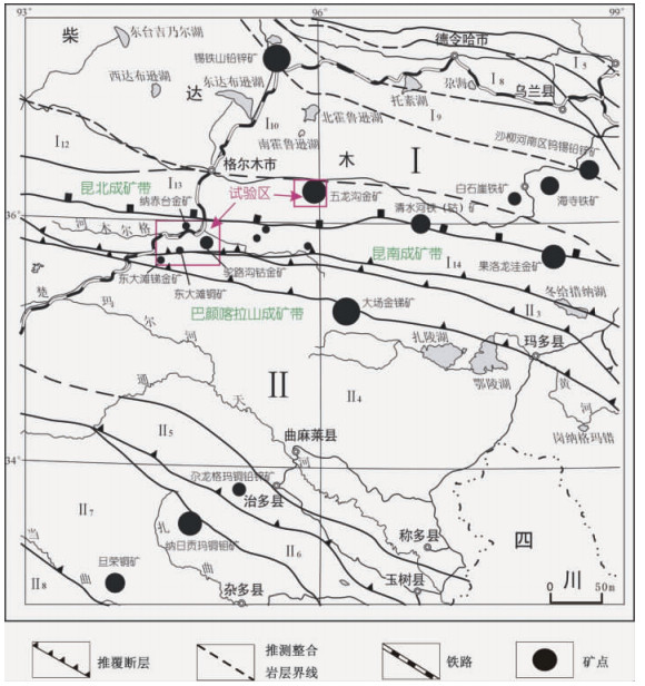
Figure 1.
Traffic location and deposit distribution map of East Kunlun area
-
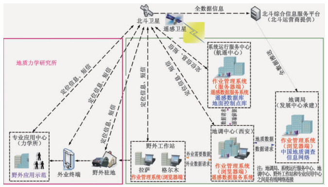
Figure 2.
The picture of information transport
-
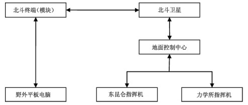
Figure 3.
A map showing positioning of Beidou terminal
-
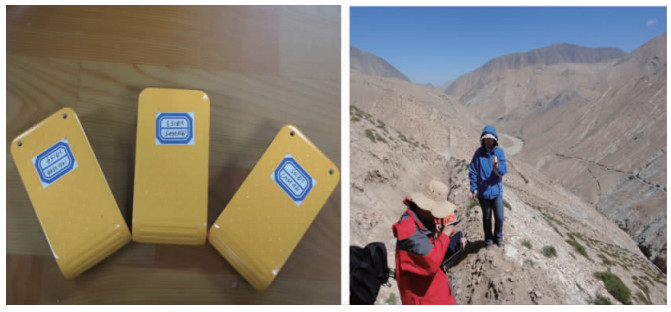
Figure 4.
The Beidou terminals and the field testing
-
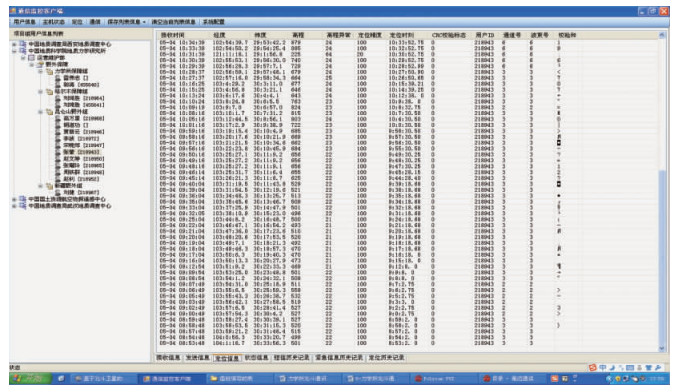
Figure 5.
Positioning information from East Kunlun Mountains and Beijing commanding center
-
Figure 6.
The track of field geological survey