
| Institute of Geomechanics, Chinese Academy of Geological Sciences | Host |
| Citation: |
CHENG Yang, LÜ Yong, TU Jie-nan, TONG Li-qiang. APPLICATION OF REMOTE SENSING TECHNOLOGY IN THE 1: 50000 REGIONAL GEOLOGICAL SURVEY IN KARST AREA: A CASE STUDY OF NORTHWEST GUIZHOU[J]. Journal of Geomechanics, 2016, 22(4): 921-932.

|
APPLICATION OF REMOTE SENSING TECHNOLOGY IN THE 1: 50000 REGIONAL GEOLOGICAL SURVEY IN KARST AREA: A CASE STUDY OF NORTHWEST GUIZHOU
-
Abstract
Karst region in Southwest China has special resources and environmental characteristics. According to these characteristics, this paper uses the multi-temporal, multi-source and multi-scale remote sensing data and applies the remote sensing technology of automatic extraction of remote sensing information and interactive interpretation to 1:50000 regional geological survey in karst area. This study provides a series of maps that are beneficial to the regional geological mapping in karst area and improves the efficiency of 1:50000 regional geological survey. Through this research, a remote sensing technology method for 1:50000 regional geological survey in karst areas in Southwest China is established, which can help researchers quickly and accurately interpret the special karst geology, geomorphology, environment, hydrology and other factors, and provide technical support for geological mapping special geological landform area.
-

-
References
[1] Mohsen Pournamdari, MazlanHashim, Amin Beiranvand Pour. Spectral transformation of Aster and Landsat TM bands for lithological mapping of Soghanophiolite complex, south Iran[J].Advance in Space Research, 2014, 54(4):694~704. doi: 10.1016/j.asr.2014.04.022 [2] 程洋, 童立强.基于背景多层次分离的遥感矿化蚀变信息提取模型及应用实例[J].遥感技术与应用, 2015, 30(3):586~591. CHENG Yang, TONG Li-qiang. The research on extraction model of the mineralization alternation information base on multi-level separate background and an application example[J]. Remote Sensing Technology and Application, 2015, 30(3):586~591. [3] 杨金中, 方洪宾, 张玉君, 等.中国西部重要成矿带遥感找矿异常提取的方法研究[J].国土资源遥感, 2003, 15(3):50~53. doi: 10.6046/gtzyyg.2003.03.12 YANG Jin-zhong, FANG Hong-bin, ZHANG Yu-jun, et al. Remote sensing anomaly extraction in important metallogenic belts of western China[J].Remote Sensing for Land and Resources, 2003, 15(3):50~53. doi: 10.6046/gtzyyg.2003.03.12 [4] Enton Bedini. Mineral mapping in Kap Simpson complex, central east Greenland, using HyMap and Aster remote sensing data[J]. Advance in Space Research, 2011, 47(1):60~73. doi: 10.1016/j.asr.2010.08.021 [5] 王润生, 甘甫平, 闫柏琨, 等.高光谱矿物填图技术与应用研究[J].国土资源遥感, 2010, 22(1):1~13. doi: 10.6046/gtzyyg.2010.01.01 WANG Run-sheng, GAN Fu-ping, YAN Bai-kun, et al. Hyperspectral mineral mapping technology and Application[J]. Remote Sensing for Land and Resources, 2010, 22(1):1~13. doi: 10.6046/gtzyyg.2010.01.01 [6] 刘德长, 童勤龙, 林子喻, 等.欧洲大陆遥感地质解译、诠释与矿产勘查战略选区[J].国土资源遥感, 2015, 27(3):136~143. doi: 10.6046/gtzyyg.2015.03.22 LIU De-chang, TONG Qin-long, LIN Zi-yu, et al. Remote sensing geological interpretation and strategy area selection for mineral exploration in Europe[J].Remote Sensing for Land and Resources, 2015, 27(3):136~143. doi: 10.6046/gtzyyg.2015.03.22 [7] 张志平, 吴勇, 焦世文, 等.遥感地质解译路线在西藏羌塘地区1:5万区域地质调查中的应用[J].甘肃地质, 2014, 23(3):82~89. ZHANG Zhi-ping, WU Yong, JIAO Shi-wen, et al. Application of remote sensing routine interpretation for 1:50000 regional geological survey in Qingtang area of Tibet[J]. Gansu Geology, 2015, 27(3):136~143. [8] 张微, 金谋顺, 张少鹏, 等.高分遥感卫星数据在东昆仑成矿带找矿预测中的应用[J].国土资源遥感, 2016, 28(2):112~119. doi: 10.6046/gtzyyg.2016.02.18 ZHANG Wei, JIN Mou-shun, ZHANG Shao-peng, et al. Application of high resolution remote sensing data to ore-prospecting prediction in East Kunlun metallogenic belt[J]. Remote Sensing for Land and Resources, 2016, 28(2):112~119. doi: 10.6046/gtzyyg.2016.02.18 [9] 张玉君, 姚佛军.应用多光谱ASTER数据对ETM遥感异常的定性判别研究-以东昆仑五龙沟为例[J].岩石学报, 2009, 25(4):963~970. ZHANG Yu-jun, YAO Fo-jun. Application study of multi-spectral ASTER data for determination of ETM remote sensing anomaly property:Taking Wulonggou region of eastern Kunlun mountain range as example[J]. Acta Petrologica Sinica, 2009, 25(4):963~970. [10] 程洋, 陈建平, 皇甫江云, 等.基于RS和GIS的岩溶石漠化恶化趋势定量预测——以广西都安瑶族自治县典型岩溶石漠化地区为例[J].国土资源遥感, 2012, 24(3):135~139. CHENG Yang, CHEN Jian-ping, HUANGFU Jiang-yun, et al. Quantitative prediction of karst rocky desertification deterioration based on RS and GIS:A case study of typical karst rocky desertification area of Du'an County, Guangxi[J]. Remote Sensing for Land and Resources, 2012, 24(3):135~139. [11] 夏涛, 杨武年, 马安青.遥感影像三维可视化在岩溶漏斗解译中的应用[J].测绘科学, 2009, 34(6):266~268. XIA Tao, YANG Wu-nian, MA An-qing. Application of 3D visualization of remote sensing images in doline interpretation[J]. Science of Surveying and Mapping, 2009, 34(6):266~268. [12] 陈梦杰, 吴虹, 刘超, 等.基于生态参数的岩溶峰丛区石灰岩基岩表面溶蚀率遥感反演[J].国土资源遥感, 2015, 27(3):71~76. doi: 10.6046/gtzyyg.2015.03.13 CHEN Meng-jie, WU Hong, LIU Chao, et al. Remote sensing inversion of dissolution rate of limestone bedrock surface based on ecological parameters in Karst areas[J].Remote Sensing for Land and Resources, 2015, 27(3):71~76. doi: 10.6046/gtzyyg.2015.03.13 [13] 杨树文, 谢飞, 冯光胜, 等.基于Spot5图像的岩溶地貌单元自动提取方法[J].国土资源遥感, 2012, 24(2):56~60. YANG Shu-wen, XIE Fei, FENG Guang-sheng, et al. Automatic Extraction of Karst Landscape Elements Based on Spot5 Image[J].Remote Sensing for Land and Resources, 2012, 24(2):56~60. [14] 程洋, 童立强, 郭兆成, 等.资源一号02C卫星数据在北京岩溶水资源勘查评价工程中的应用[J].国土资源遥感, 2015, 27(2):183~189. CHENG Yang, TONG Li-qiang, GUO Zhao-chen, et al. Application of satellite data of ZY1-02C to the exploration engineering of Karst water resources in Beijing[J].Remote Sensing for Land and Resources, 2015, 27(2):183~189. [15] 刘春玲, 童立强, 丁富海.云南九龙河流域的水文地质遥感影像特征研究[J].工程地质学报, 2008, 16(S1):188~192. LIU Chun-ling, TONG Li-qiang, DING Fu-hai, et al. The characteristics of hydro-geological remote sensing image of Jiulonghe river valley in Yunnan Province[J]. Journal of Engineering Geology, 2008, 16(S1):188~192. [16] 刘汉湖, 杨武年, 杨容浩.结合遥感和地学知识的高原机场工程地质评价[J].测绘科学, 2014, 39(7):94~97. LIU Han-hu, YANG Wu-nian, YANG Rong-hao.Discussion on geological evaluation of plateau airport engineering using remote sensing and geoscience knowledge[J]. Science of Surveying and Mapping, 2014, 39(7):94~97. [17] 莫源富, 奚小双.植被覆盖茂密区碳酸盐岩岩性的遥感识别-以灌江流域为例[J].桂林理工大学学报, 2010, 30(1):41~46. MO Yuan-fu, XI Xiao-shuang. Carbonate Rock Lithological Discrimination by Remote Sensing Data for Areas with Flourishing Vegetation-A Case from Guangjiang Drainage Area[J]. Journal of Guilin University of Technology, 2010, 30(1):41~46. [18] 童立强.西南岩溶石山地区石漠化信息自动提取技术研究[J].国土资源遥感, 2003, 15(4):35~38. doi: 10.6046/gtzyyg.2003.04.09 TONG Li-qiang. A method for extracting remote sensing information from rock desertification areas in southwest China[J].Remote Sensing for Land and Resources, 2003, 15(4):35~38. doi: 10.6046/gtzyyg.2003.04.09 -
Access History

Figures(11)
Tables(2)

Export File
Citation
CHENG Yang, LÜ Yong, TU Jie-nan, TONG Li-qiang. APPLICATION OF REMOTE SENSING TECHNOLOGY IN THE 1: 50000 REGIONAL GEOLOGICAL SURVEY IN KARST AREA: A CASE STUDY OF NORTHWEST GUIZHOU[J]. Journal of Geomechanics, 2016, 22(4): 921-932.
Format
Content
 DownLoad:
-
Figure 1.
Location map of the study area
-
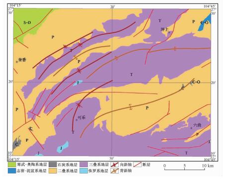
Figure 2.
Geological sketch map of the study area
-
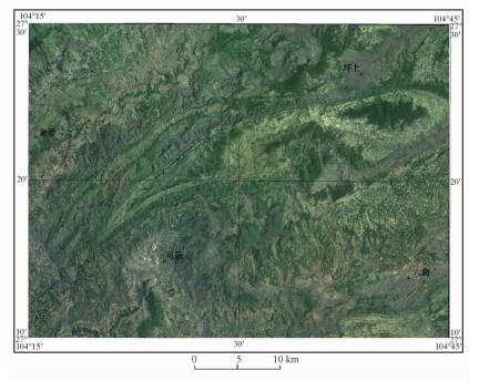
Figure 3.
DOM of the study area(GF-1)
-
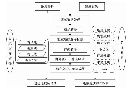
Figure 4.
Technique flowchart
-
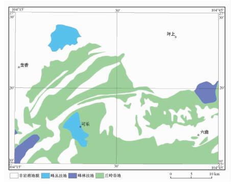
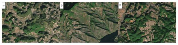
Figure 5.
Interpretation map of karst landform
-
Figure 6.
Remote sensing interpretation symbol of typical rock strata
-
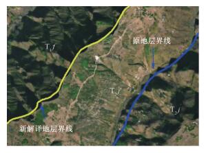
Figure 7.
Schematic diagram of new stratigraphic deciphering
-
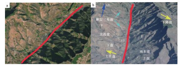
Figure 8.
Schematic diagram of typical faults
-
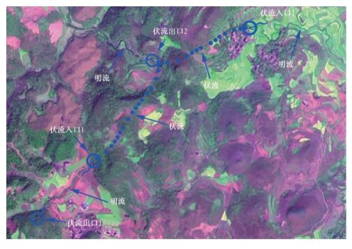
Figure 9.
Interpretation map of subterranean river system
-
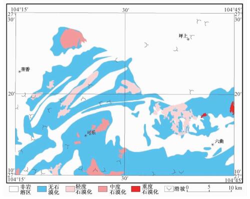
Figure 10.
Interpretation map of environmental geology
-
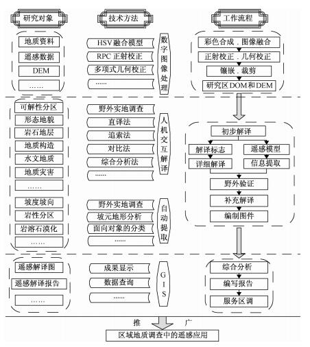
Figure 11.
System diagram of remote sensing method