
| Institute of Geomechanics, Chinese Academy of Geological Sciences | Host |
| Citation: |
MENG Peng-yan, SUN Jie, YU Chang-chun, MU Chao, SHUAI Shuang, XIE Fei, MENG Dan. LITHOLOGICAL INFORMATION EXTRACTION IN MOUNTAIN CANYON REGION BASED ON MULTI-SOURCE REMOTE SENSING DATA: A CASE STUDY OF 1: 50000 PILOT GEOLOGICAL MAPPING IN BEISHAN AREA IN WUSHI, XINJIGAN[J]. Journal of Geomechanics, 2016, 22(4): 907-920.

|
LITHOLOGICAL INFORMATION EXTRACTION IN MOUNTAIN CANYON REGION BASED ON MULTI-SOURCE REMOTE SENSING DATA: A CASE STUDY OF 1: 50000 PILOT GEOLOGICAL MAPPING IN BEISHAN AREA IN WUSHI, XINJIGAN
-
Abstract
The location of 1:50000 pilot geological mapping program in Beishan, Wushi County, lies at the junction point of north-west margin of Tarim basin and south-west of Tianshan. According to the geomorphic characteristics of high altitude and deep negative relief, the study area belongs to alpine valley region. Based on the typical lithology spectral absorption characteristics, we carried out some research on the enhancement and absorption of lithologic differences information, and summarized a series of methods to divide the lithological units margins according to multi-source remote sensing data. On the foundation of ASTER, ASTER and SPOT6 cooperative data, ASTER and GF-2 cooperative data, we choose the best wave combination to synthesize RGB color and enhance the difference between images. And we preliminarily mark the boundaries of different image units according to the known geological data of study area. Then, the final lithology units can be interpreted by combining field survey data, realistic geological background, and geomorphic images. Thus, the study results provide reference for further optimized stratum division and comparison.
-

-
References
[1] 王润生, 熊盛青, 聂洪峰, 等.遥感地质勘查技术与应用研究[J].地质学报, 2011, 85(11):1699~1743. WANG Run-sheng, XIONG Sheng-qing, NIE Hong-feng, et al. Remote sensing technology and its application in geological exploration[J]. Acta Geologica Sinica, 2011, 85(11):1699~1743. [2] Hunt G R, Salisbury J W. Visible and near infrared spectra of minerals and rocks Ⅰ:Silieate minerals[J]. Modern Geology, 1970, 1:238~300. [3] Hunt G R, Salisbury J W. Visible and Near Infrared Spectra of Minerals and Rocks Ⅱ:Carbonates[J]. Modern Geology, 1971, 2:23~30. [4] 燕守勋, 武晓波, 周朝宪, 等.遥感和光谱地质进展及其对矿产勘查的实践应用[J].地球科学进展, 2011, 26(1):13~29. YAN Shou-xun, WU Xiao-bo, ZHOU Chao-xian, et al. Remote sensing and spectral geology and their applications to mineral exploration[J]. Advances in Earth Science, 2011, 26(1):13~29. [5] 甘甫平, 王润生, 马蔼乃, 等.光谱遥感岩矿识别基础与技术研究进展[J].遥感技术与应用, 2002, 17(3):140~147. doi: 10.11873/j.issn.1004-0323.2002.3.140 GAN Fu-ping, WANG Run-sheng, MA Ai-nai, et al. The development and tendency of both basis and techniques of discrimination for minerals and rocks using spectral remote sensing data[J]. Remote Sensing Technology and Application, 2002, 17(3):140~147. doi: 10.11873/j.issn.1004-0323.2002.3.140 [6] 王晋年, 李志忠, 张立福, 等. "光谱地壳"计划——探索新一代矿产勘查技术[J].地球信息科学学报, 2012, 14(3):344~351. WANG Jin-nian, LI Zhi-zhong, ZHANG Li-fu, et al. "Spectral Crust" project:Research on new mineral exploration technology[J]. Journal of Geo-Information Science, 2012, 14(3):344~351. [7] 刘超群, 马祖陆, 莫源富.遥感岩性识别研究进展与展望[J].广西科学院学报, 2007, 23(2):120~124. LIU Chao-qun, MA Zu-lu, MO Yuan-fu. Progress and prospect of study on remote sensing lithologic identification[J]. Journal of Guangxi Academy of Sciences, 2007, 23(2):120~124. [8] Loughlin W. Principal component analysis for alteration mapping[J]. Photogrammetric Engineering & Remote Sensing, 1991, 57(9):1163~1169. [9] 丑晓伟, 傅碧宏.干旱区TM图像岩石地层信息提取与分析方法研究[J].沉积学报, 1995, (s1):164~170. CHOU Xiao-wei, FU Bi-hong. Extraction and analysis of lithostratigraphic information from Landsat Thematic Mapper Imagery in arid region[J]. Acta Sedimentologica Sinica, 1995, (s1):164~170. [10] Rowan L C, Mars J C, Simpson C J. Lithologic mapping of the Mordor, NT, Australia ultramafic complex by using the Advanced Spaceborne Thermal Emission and Reflection Radiometer (ASTER)[J]. Remote Sensing of Environment, 2005, 99(1/2):105~126. [11] 时丕龙, 付碧宏, 二宫芳树.基于ASTER VNIR-SWIR多光谱遥感数据识别与提取干旱地区岩性信息——以西南天山柯坪隆起东部为例[J].地质科学, 2010, 45(1):333~347. SHI Pi-long, FU Bi-hong, Ninomiya Y. Detecting lithologic features from ASTER VNIR-SWIR multispectral data in the arid region:A case study in the eastern Kalpin uplift, southwest Tianshan[J]. Chinses Journal of Geology, 2010, 45(1):333~347. [12] 刘本培.西南天山构造格局与演化[M].武汉:中国地质大学出版社, 1996. LIU Ben-pei. Tectonic pattern and evolution of southwest Tianshan[M]. Wuhan:China University of Geosciences Press, 1996. [13] 梁群峰, 杨克俭, 杨运军, 等.西南天山梅尔盖西地区成矿地质条件及成矿预测[J].西北地质, 2013, 46(1):91~102. LIANG Qun-feng, YANG Ke-jian, YANG Yun-jun, et al. Metallogenic prognosis in the Meiergaixi region, southwest Tianshan orogeny[J]. Northwestern Geology, 2013, 46(1):91~102. [14] 赵仁夫, 杨建国, 王满仓, 等.西南天山地区矿产资源潜力综合评价报告[R].西安:西安地质矿产研究所, 2003. ZHAO Ren-fu, YANG Jian-guo, WANG Man-cang, et al. Comprehensive evaluation report on mineral resources potential in southwest Tianshan region[R]. Xi'an:Xi'an Institute of Geology and Mineral Resources, 2003. [15] Itami H, Roehl T W. Mobilizing Invisible Assets[M]. Harvard University Press, 1991. [16] 马艳华.高空间分辨率和高光谱分辨率遥感图像的融合[J].红外, 2003, (10):11~16. doi: 10.3969/j.issn.1672-8785.2003.10.003 MA Yan-hua. Fusion of high spatial resolution and high spectral resolution remote sensing image[J]. Infrared, 2003, (10):11~16. doi: 10.3969/j.issn.1672-8785.2003.10.003 [17] Hunt G R. Spectral signatures of particulate minerals in the visible and near infrared[J]. Geophysics, 1977, 42(3):501. doi: 10.1190/1.1440721 [18] Amer R, Kusky T, Ghulam A. Lithological mapping in the central eastern desert of Egypt using ASTER data[J]. Journal of African Earth Sciences, 2010, 56(2):75~82. [19] 杨可明, 刘士文, 王林伟, 等.光谱最小信息熵的高光谱影像端元提取算法[J].光谱学与光谱分析, 2014, 34(8):2229~2233. YANG Ke-ming, LIU Shi-wen, WANG Lin-wei, et al. An algorithm of Spectral Minimum Shannon Entropy on extracting endmember of hyperspectral image[J]. Spectroscopy and Spectral Analysis, 2014, 34(8):2229~2233. [20] 褚海峰, 翟中敏, 赵银娣, 等.一种多/高光谱遥感图像端元提取的凸锥分析算法[J].遥感学报, 2007, 11(4):460~467. doi: 10.11834/jrs.20070464 CHU Hai-feng, ZHAI Zhong-min, ZHAO Yin-di, et al. A Convex Cone Analysis Method for end member selection of multispectral and hyperspectral images[J]. Journal of Remote Sensing, 2007, 11(4):460~467. doi: 10.11834/jrs.20070464 [21] 高晓惠, 相里斌, 魏儒义, 等.基于光谱分类的端元提取算法研究[J].光谱学与光谱分析, 2011, 31(7):1995~1998. GAO Xiao-hui, XIANG Li-bin, WEI Ru-yi, et al. Research on endmember extraction algorithm based on spectral classification[J]. Spectroscopy and Spectral Analysis, 2011, 31(7):1995~1998. -
Access History
Figures(12)
Tables(2)

Export File
Citation
MENG Peng-yan, SUN Jie, YU Chang-chun, MU Chao, SHUAI Shuang, XIE Fei, MENG Dan. LITHOLOGICAL INFORMATION EXTRACTION IN MOUNTAIN CANYON REGION BASED ON MULTI-SOURCE REMOTE SENSING DATA: A CASE STUDY OF 1: 50000 PILOT GEOLOGICAL MAPPING IN BEISHAN AREA IN WUSHI, XINJIGAN[J]. Journal of Geomechanics, 2016, 22(4): 907-920.
Format
Content
 DownLoad:


-
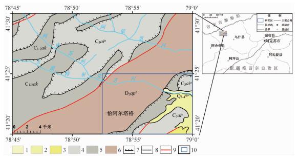
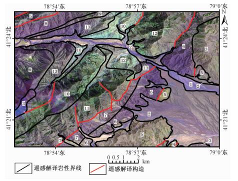
Figure 1.
Location and geological sketch of the study area
-
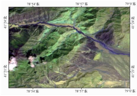
Figure 2.
Original image of ASTER (R:8, G:4, B:1)
-
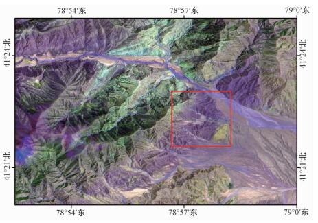
Figure 3.
Cooperative image of ASTER and SPOT6 (R:8, G:4, B:1)
-
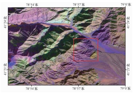
Figure 4.
Cooperative image of ASTER and GF-2 (R:8, G:4, B:1)
-
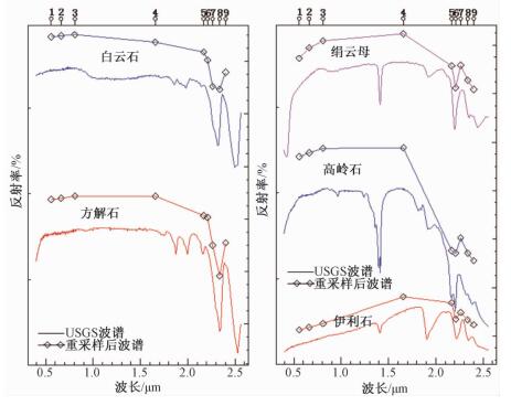
Figure 5.
Spectral curves of carbonate minerals and typical clay minerals
-
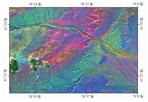
Figure 6.
Synthesized color image according to mineral abundance index
-
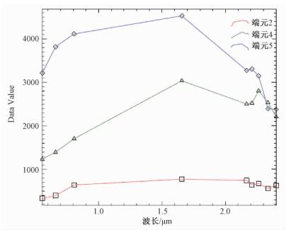
Figure 7.
The spectral extracted by SMACC algorithm
-
Figure 8.
Synthesis image according to SMACC end member abundance
-
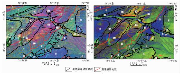
Figure 9.
Lithology and structure map interpreted by remote sensing image of study area
-
Figure 10.
Stacking chart of mineral abundance index image, synthesis image of SMACC end member abundance and lithology-structure map
-
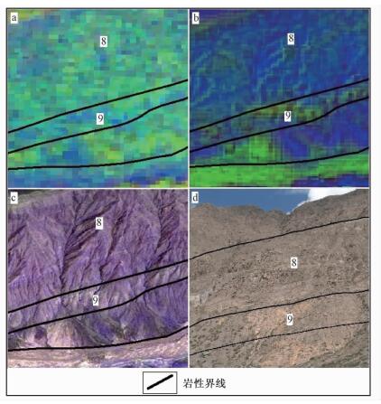
Figure 11.
The remote sensing and field outcrop geological characteristics of lithology unit 8 and unit 9
-
Figure 12.
Outcrop photos of lithology units