
| Qingdao Institute of marine geology, China Geological Survey | Host |
| Citation: |
LIU Acheng, GUO Weiqi, CHEN Xinxi, ZHANG Jie, TANG Jianzhong, LI Jianing, QIN Wei. Topography characteristics and the origination of valleys at the upper edge of continental slope in the northern East China Sea[J]. Marine Geology & Quaternary Geology, 2025, 45(2): 22-30. doi: 10.16562/j.cnki.0256-1492.2023101101

|
Topography characteristics and the origination of valleys at the upper edge of continental slope in the northern East China Sea
-
Abstract
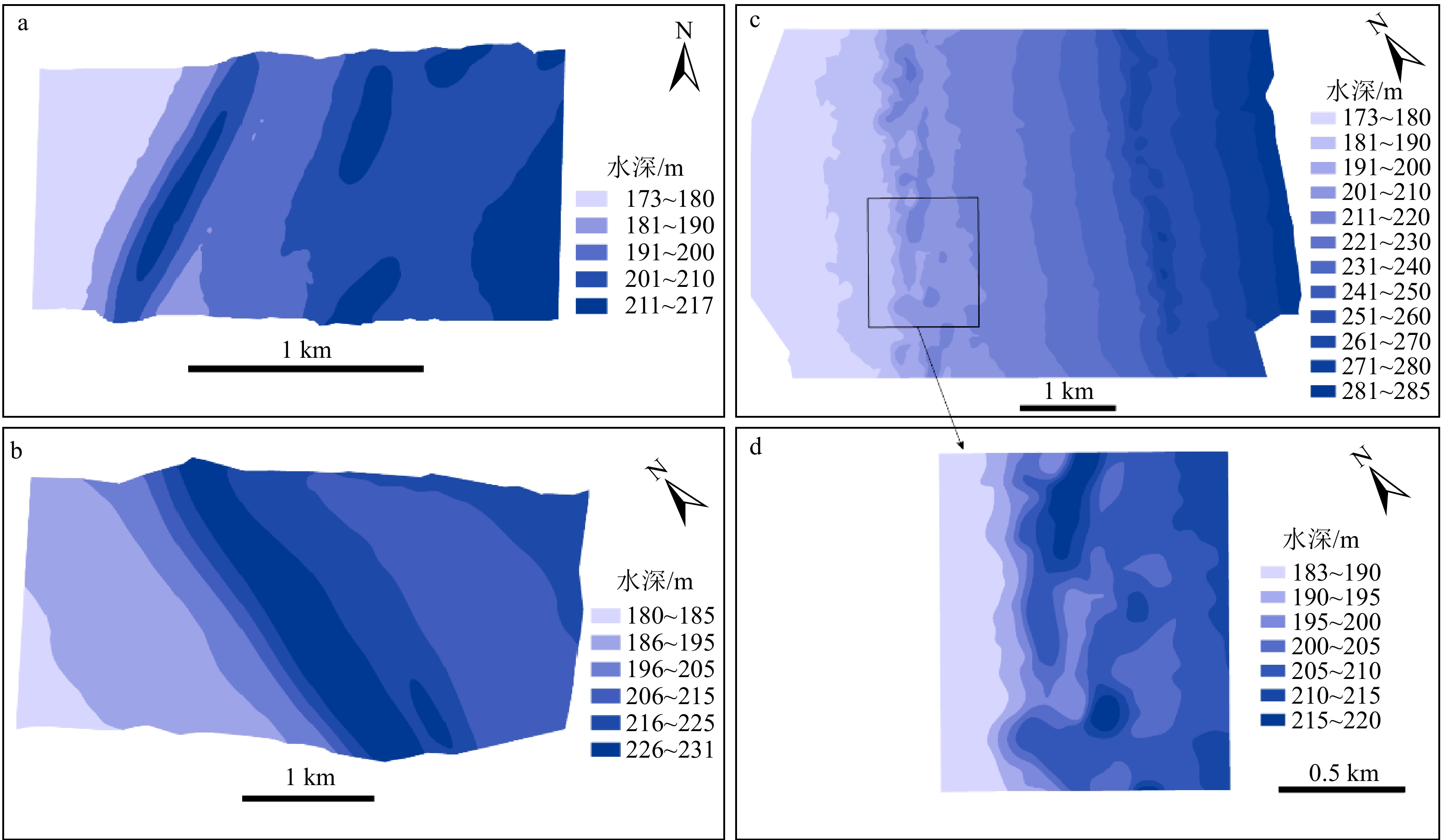
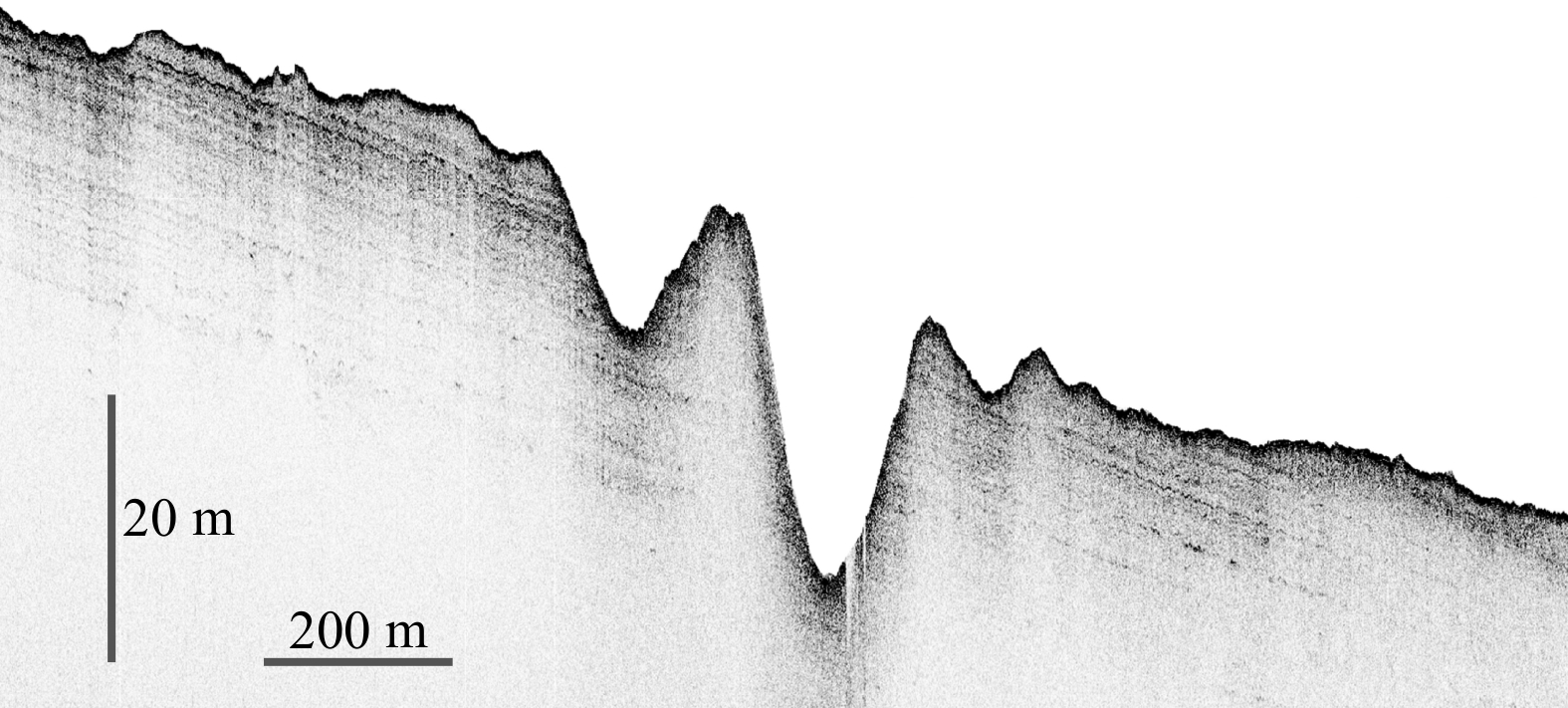
The upper edge of the continental slope of the East China Sea is a transitional zone between two main geomorphological units: the continental shelf of the sea and Okinawa Trough. Research into its geomorphological characteristics and origination is meaningful for better understanding the interaction between these two units, and the sea level changes during the late period of Late Pleistocene. Multibeam sounding and subbottom profile surveys revealed sea bottom valleys at the upper edge of the continental slope in the northern East China Sea. The valleys extend in NNE-SSW direction in quasi-parallel to the continental shelf break with an average distance of about 7 km. The depth of the slope break is about 150 m on average. It is also generally parallel to normal faults in the continental slope. They can be subdivided into single valleys and locally double-valleys. The later ones consist of a main west valley and an auxiliary east valley with an interval about 2km. All the valleys have a higher west slope and a lower east one, 400~1600 m wide and 20~25 m deep in general. The single valleys have straight depth contours and gentle bottom topography, while the double-valleys have rather complicated topography, with minor gullies cutting down valley slopes and frequently uneven bottom and so on. Subbottom profiles across the west valley show the upper 10~15m strata having parallel reflection waves, forming an eastward-dipping structure, which is the paleo-Changjiang prodelta of the late period of Late Pleistocene. Cone penetration pest (CPT) measurements of 3m deep at 170 m depth west of the west valley are interpreted as surficial loose silty sands, and interbedded silt/clay with sands downward. Side-scan sonar images near the CPT site showed sea bottom sandwaves with amplitude about 0.5 m and wave length of 6~9 m. It is inferred that the location and layout of the valleys were affected by normal faults in the continental slope related to the third phase of the Okinawa Trough expansion. Taking into account the shell 14C dating of nearby borehole samples and sea level change curves, the valleys were formed mainly during 17.4~14.5 kaBP, which is the early stage of sea level rising after the last glacial maximum (LGM), when the area was in offshore-shallow sea environment and underwent tidal current scouring. Therefore, these valleys are fault-scouring valleys. The complicated topography of the double-valleys was related to submarine landslides of paleo-Changjiang predelta deposits. The measured 200 m depth contour lines of sea bottom are mostly within the west valley but partly to the east of the valley, resulting in the intersection of each other; and their similar stretching directions were considered to be resulted from the regional tectonic framework.
-

-
References
[1] 杨文达, 崔征科, 张异彪. 东海地质与矿产[M]. 北京: 海洋出版社, 2010: 65-87, 98-103, 467-475 YANG Wenda, CUI Zhengke, ZHANG Yibiao. Geology and Ores in the East China Sea[M]. Beijing: Ocean Press, 2010: 65-87, 98-103, 467-475.] [2] 刘忠臣, 陈义兰, 丁继胜, 等. 东海海底地形分区特征和成因研究[J]. 海洋科学进展, 2003, 21(2):160-173 doi: 10.3969/j.issn.1671-6647.2003.02.005 LIU Zhongchen, CHEN Yilan, DING Jisheng, et al. Study on zoned characteristics and formation cause of the East China Sea submarine topography[J]. Advances in Marine Science, 2003, 21(2):160-173.] doi: 10.3969/j.issn.1671-6647.2003.02.005 [3] Sibuet J C, Hsu S K, Shyu C T, et al. Structural and kinematic evolutions of the Okinawa trough Backarc Basin[M]//Taylor B. Backarc Basins: Tectonics and Magmatism. New York: Springer, 1995: 343-379. [4] 吴自银, 王小波, 金翔龙, 等. 冲绳海槽弧后扩张证据及关键问题探讨[J]. 海洋地质与第四纪地质, 2004, 24(3):67-76 WU Ziyin, WANG Xiaobo, JIN Xianglong, et al. The evidences of the backarc spreading and discussion on the key issues in the Okinawa Trough[J]. Marine Geology & Quaternary Geology, 2004, 24(3):67-76.] [5] Gungor A, Lee G H, Kim H J, et al. Structural characteristics of the northern Okinawa Trough and adjacent areas from regional seismic reflection data: geologic and tectonic implications[J]. Tectonophysics, 2012, 522-523:198-207. doi: 10.1016/j.tecto.2011.11.027 [6] 马秀冬, 李萍, 徐元芹, 等. 冲绳海槽中段海底灾害地质类型及海底稳定性评价[J]. 海洋科学进展, 2018, 36(1):79-87 doi: 10.3969/j.issn.1671-6647.2018.01.007 MA Xiudong, LI Ping, XU Yuanqin, et al. Submarine geohazards types and seabed stability evaluation of the middle part of the Okinawa trough[J]. Advances in Marine Science, 2018, 36(1):79-87.] doi: 10.3969/j.issn.1671-6647.2018.01.007 [7] 陈珊珊, 王中波, 张勇, 等. 东海北部外陆架及邻区灾害地质体特征及成因研究[J]. 中国地质, 2020, 47(5):1512-1529 CHEN Shanshan, WANG Zhongbo, ZHANG Yong, et al. Characteristics and origin of disaster geological bodies in the northern outer shelf of the East China Sea and its adjacent areas[J]. Geology in China, 2020, 47(5):1512-1529.] [8] 范奉鑫, 林美华. 东海北部陆架外缘的边缘沟、坎[J]. 海洋与湖沼, 1999(3):53-56 FAN Fengxin, LIN Meihua. Marginal gully and scanp on the outer continental shelf margin of the East China Sea[J]. Marine Sciences, 1999(3):53-56.] [9] 吴自银, 李家彪, 金翔龙, 等. 冲绳海槽海底地形地貌界限特征及影响因素[J]. 中国科学: 地球科学, 2014, 44(7): 1477-1487 WU Ziyin, LI Jiabiao, JIN Xianglong, et al. Distribution, features, and influence factors of the submarine topographic boundaries of the Okinawa Trough[J]. Science China:Earth Sciences, 2014, 57(8): 1885-1896.] [10] 袁迎如. 东海大陆架外部的晚更新世晚期长江河口[J]. 海洋学报, 1992, 14(6):85-91 YUAN Yingru. Changjiang estuary in outer shelf of East China Sea during the late period of the Late Pleistocene[J]. Acta Oceanologica Sinica, 1992, 14(6):85-91.] [11] 范奉鑫, 阎军, 陈长安, 等. 冲绳海槽北部西坡的古三角洲沉积[J]. 海洋科学集刊, 2007(48):42-54 FAN Fengxin, YAN Jun, CHEN Changan, et al. Paleo-delta deposition in the west slope of the northern Okinawa Trough[J]. Studia Marina Sinica, 2007(48):42-54.] [12] Robertson P K. Soil classification using the cone penetration test[J]. Canadian Geotechnical Journal, 1990, 27(1):151-158. doi: 10.1139/t90-014 [13] 陈培雄, 潘国富, 陈小玲. 海底浅表层不同土类静力触探参数与物理力学性质对比研究[J]. 海洋通报, 2009, 28(6):118-121 doi: 10.3969/j.issn.1001-6392.2009.06.021 CHEN Peixiong, PAN Guofu, CHEN Xiaoling. Correlative analyses of cone penetration test parameters and physicomechanical properties for different seabed soil types[J]. Marine Science Bulletin, 2009, 28(6):118-121.] doi: 10.3969/j.issn.1001-6392.2009.06.021 [14] 陈小玲, 陈培雄, 陈锡土, 等. 海底管线区浅表层土孔压静力触探参数特征及应用[J]. 海洋科学, 2012, 36(3):8-12 CHEN Xiaoling, CHEN Peixiong, CHEN Xitu, et al. Characteristics of pore pressure static cone penetration test parameters and its application of surface soil in pipeline laying areas[J]. Marine Sciences, 2012, 36(3):8-12.] [15] 杨德周, 许灵静, 尹宝树, 等. 黑潮跨陆架入侵东海年际变化的数值模拟[J]. 海洋与湖沼, 2017, 48(6):1318-1327 doi: 10.11693/hyhz20170500139 YANG Dezhou, XU Lingjing, YIN Baoshu, et al. Numerical study on inter-annual variation of cross-shelf intrusion of Kuroshio into East China Sea[J]. Oceanologia et Limnologia Sinica, 2017, 48(6):1318-1327.] doi: 10.11693/hyhz20170500139 [16] 吴自银, 温珍河. 中国近海海洋地质[M]. 北京: 科学出版社, 2021: 36-37 WU Ziyin, WEN Zhenhe. Marine Geology of China Seas[M]. Beijing: Science Press, 2021: 36-37.] [17] 刘振夏, 夏东兴. 中国近海潮流沉积沙体[M]. 北京: 海洋出版社, 2004: 46-52 LIU Zhenxia, XIA Dongxing. Tidal Sands in the China Seas[M]. Beijing: China Ocean Press, 2004: 46-52.] [18] 梅西, 李学杰, 密蓓蓓, 等. 中国海域表层沉积物分布规律及沉积分异模式[J]. 中国地质, 2020, 47(5):1447-1462 MEI Xi, LI Xuejie, MI Beibei, et al. Distribution regularity and sedimentary differentiation patterns of China seas surface sediments[J]. Geology in China, 2020, 47(5):1447-1462.] [19] Iseki K, Okamura K, Kiyomoto Y. Seasonality and composition of downward particulate fluxes at the continental shelf and Okinawa Trough in the East China Sea[J]. Deep Sea Research Part II: Topical Studies in Oceanography, 2003, 50(2):457-473. doi: 10.1016/S0967-0645(02)00468-X [20] Katayama H, Watanabe Y. The Huanghe and Changjiang contribution to seasonal variability in terrigenous particulate load to the Okinawa Trough[J]. Deep Sea Research Part II: Topical Studies in Oceanography, 2003, 50(2):475-485. doi: 10.1016/S0967-0645(02)00469-1 [21] 辛立国, 李广雪, 李西双, 等. 中国东海2万年来海平面变化分析[J]. 中国海洋大学学报, 2006, 36(5):699-704,698 XIN Liguo, LI Guangxue, LI Xisuang, et al. Analysis of sea-level variation in the East China Sea since the Last Glacial Maximum[J]. Periodical of Ocean University of China, 2006, 36(5):699-704,698.] [22] 张异彪, 刘峰, 杨文达. 中国矿产地质志-东海卷[M]. 北京: 地质出版社, 2022: 35-36 ZHANG Yibiao, LIU Feng, YANG Wenda. Geology of Mineral Resources in China[M]. Beijing: Geological Publishing House, 2022: 35-36.] [23] Waelbroeck C, Labeyrie L, Michel E, et al. Sea-level and deep water temperature changes derived from benthic foraminifera isotopic records[J]. Quaternary Science Reviews, 2002, 21(1-3):295-305. doi: 10.1016/S0277-3791(01)00101-9 [24] 王利波, 李军, 陈正新, 等. 晚更新世以来台湾浅滩西部地层结构与古环境演化[J]. 沉积学报, 2014, 32(6):1089-1099 WANG Libo, LI Jun, CHEN Zhengxin, et al. Late Pleistocene and Holocene stratigraphy and paleo-environmental evolution in the western Taiwan shoal[J]. Acta Sedimentologica Sinica, 2014, 32(6):1089-1099.] [25] 周勐佳, 吴自银, 马胜中, 等. 台湾海峡晚更新世以来的高分辨率地震地层学研究[J]. 海洋学报, 2016, 38(9):76-88 doi: 10.3969/j.issn.0253-4193.2016.09.008 ZHOU Mengjia, WU Ziyin, MA Shengzhong, et al. High resolution seismic stratigraphy research in the Taiwan Strait since late Pleistocene[J]. Haiyang Xuebao, 2016, 38(9):76-88.] doi: 10.3969/j.issn.0253-4193.2016.09.008 [26] Liu J P, Milliman J D. Reconsidering melt-water pulses 1A and 1B: global impacts of rapid sea-level rise[J]. Journal of Ocean University of China, 2004, 3(2):183-190. doi: 10.1007/s11802-004-0033-8 [27] 陈珊珊, 王中波, 陆凯, 等. 东海北部外陆架MIS 6以来的沉积地层格架及古环境演化[J]. 海洋地质与第四纪地质, 2019, 39(6):124-137 CHEN Shanshan, WANG Zhongbo, LU Kai, et al. Sedimentary stratigraphic framework and palaeoenvironmental evolution of the northern outer shelf of East China Sea since MIS 6[J]. Marine Geology & Quaternary Geology, 2019, 39(6):124-137.] [28] Hu G H, Yan T, Liu Z X, et al. Size distribution of submarine landslides along the middle continental slope of the East China Sea[J]. Journal of Ocean University of China, 2009, 8(4):322-326. doi: 10.1007/s11802-009-0322-3 -
Access History
Figures(8)

Export File
Citation
LIU Acheng, GUO Weiqi, CHEN Xinxi, ZHANG Jie, TANG Jianzhong, LI Jianing, QIN Wei. Topography characteristics and the origination of valleys at the upper edge of continental slope in the northern East China Sea[J]. Marine Geology & Quaternary Geology, 2025, 45(2): 22-30. doi: 10.16562/j.cnki.0256-1492.2023101101
Format
Content
 DownLoad:


-
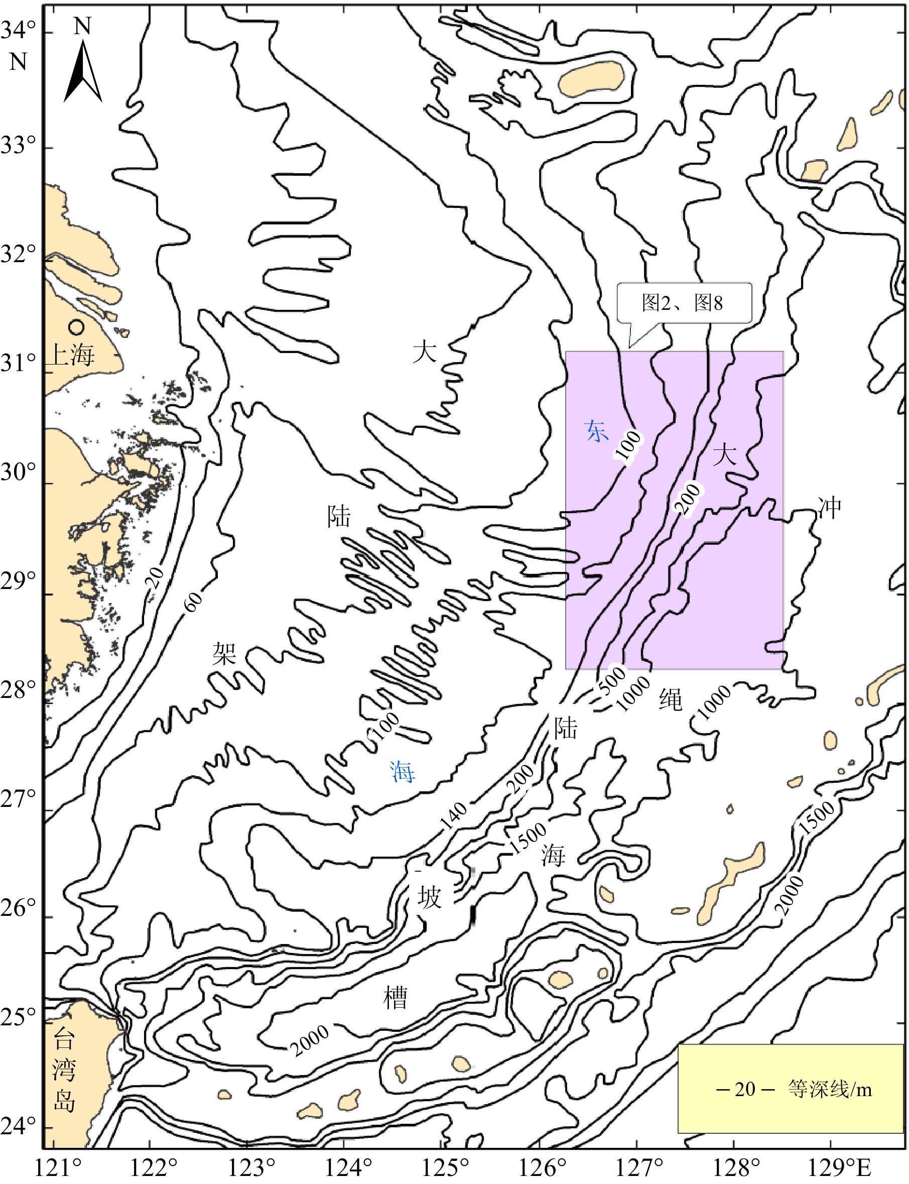
Figure 1.
Topography of the East China Sea
-
Figure 2.
Locations of survey areas and main geomorphology
-
Figure 3.
Typical sections of sea bottom topography
-
Figure 4.
Simplified topography of valleys interpreted by data of multibeam sounding
-
Figure 5.
Subbottom profile across the west valley
-
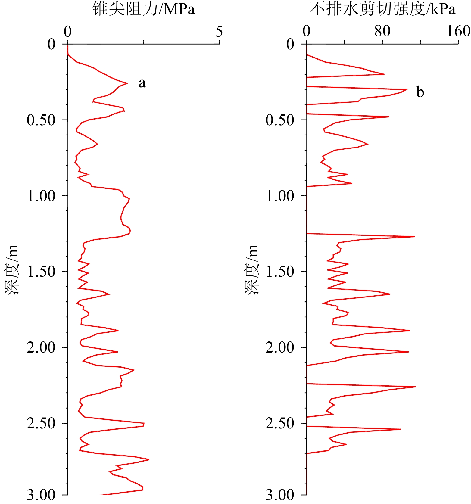
Figure 6.
CPT record curves
-
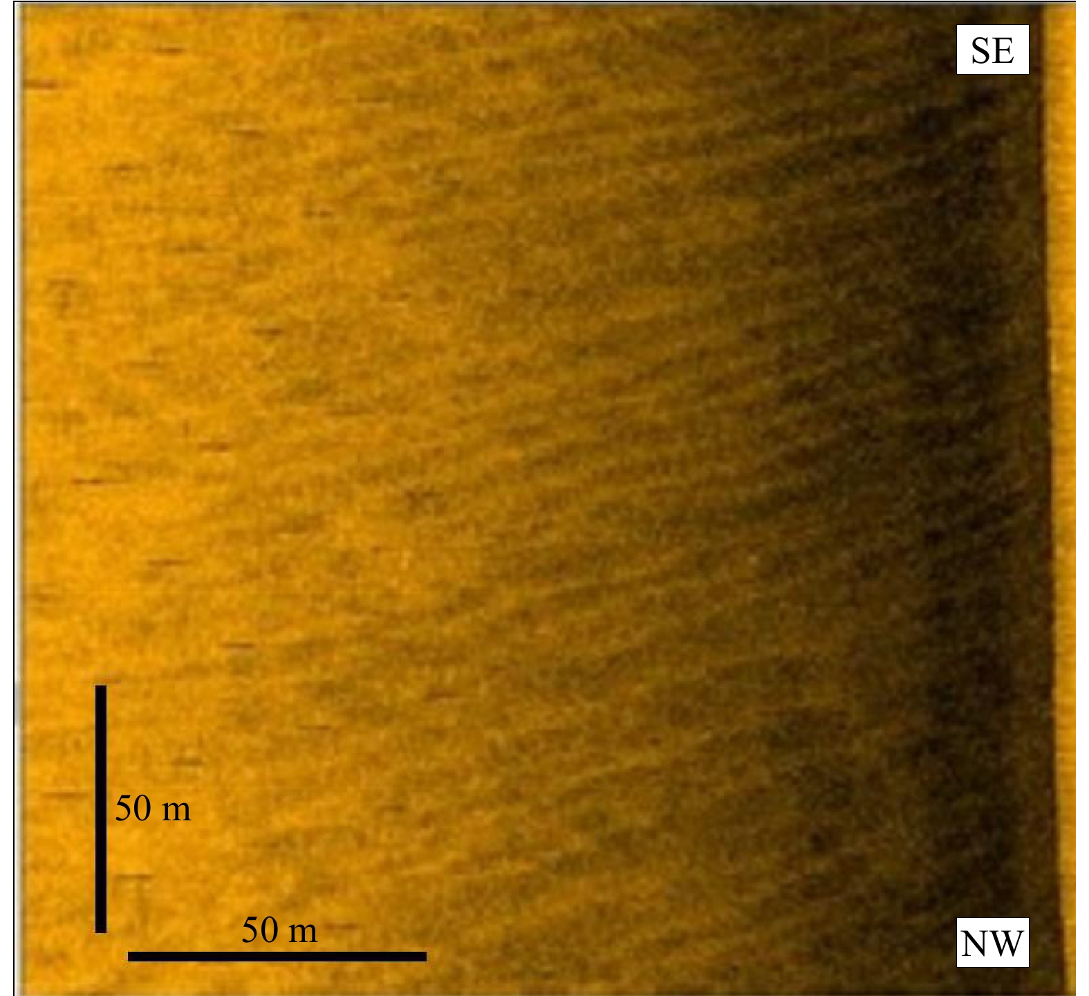
Figure 7.
Side scan sonar images of sandwaves
-
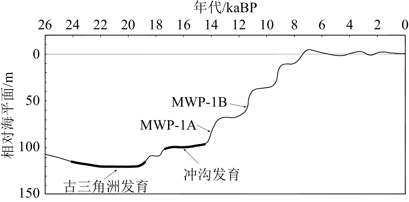
Figure 8.
Sea level change and developmental periods of paleo-delta and scouring valleys