
| Citation: |
WANG Chunhui, TIAN Puyuan, GUO Shujun, SUN Sheng. 2024. Technical breakthrough and practice of ground penetrating radar in the exploration of Baiyangdian lake bottom stratum structure. Geological Bulletin of China, 43(4): 651-657. doi: 10.12097/gbc.2022.03.017

|
Technical breakthrough and practice of ground penetrating radar in the exploration of Baiyangdian lake bottom stratum structure
-
Abstract
The investigation of the Baiyangdian lake bottom strata holds significant practical importance for the ecological geological survey, ecological silt removal, and wetland ecological protection of Baiyangdian. In order to systematically identify the stratigraphic structure of Baiyangdian lake at a regional scale and provide accurate target data support for drilling investigations, this paper introduces an innovative application range of ground penetrating radar (GPR) and conducts a ship-based stratigraphic survey through the water body. This study analyzes the technical challenges associated with exploring the lake bottom structure using GPR. It examines the characteristics of electromagnetic wave propagation and geophysical response conditions in two scenarios: with sediment and without sediment. A simplified model is established, consisting of diaster-water + silt layer + lake bottom primary formation. By comparing the exploration capability and adaptation conditions of different hardware equipment of mainstream ground penetrating radar systems at home and abroad, this paper optimizes the working mode by employing double kayaks equipped with a 50 MHz low-frequency combined antenna. Additionally, it combines suitable data processing technology for extracting weak signals from underwater electromagnetic waves. As a result, stratigraphic structure data at a depth of 15m are obtained for Baiyangdian lake. The findings indicate that this model is applicable to areas within the lake where water depth is less than 5 m; here, weak reflection characteristics are observed in electromagnetic waves emitted by primary formations at the lake bottom along with 2 ~ 3 groups of sand reflection interfaces at depths up to 15 m. The presence of silt layers significantly attenuates electromagnetic wave reflection intensity originating from primary strata at the lake bottom.
-

-
References
[1] Ardekani M, Druyts P, Lambot S. 2014. Recovering the structure of a layered soil, including layer thickness and dielectric permittivity, using theinterfaces and objects backscatter detected in GPR b−scans[C]//Proceedings of the 15th International Conference on Ground Penetrating Radar (GPR 2014), Brussels: 397–400. [2] Baek S, Kim S, Known J, et al. 2017. Ground penetrating radar for facture mapping in underground hazardous waste disposal sites: a case study from an underground research tunnel, South Korea[J]. Appl. Geophys., 141: 24−33. doi: 10.1016/j.jappgeo.2017.03.017 [3] De Coster A, L Pérez J, Medina M. 2019. Towards an improvement of GPR−based detection of pipes and leaksin water distribution networks[J]. Journal of Applied Geophysics, 162: 138−151. doi: 10.1016/j.jappgeo.2019.02.001 [4] Filippo B, Lukas K, Bjørn K M, et al. 2023. Mapping inland water bathymetry with Ground Penetrating Radar (GPR) on board Unmanned Aerial Systems (UASs)[J]. Journal of Hydrology, 616: 128789. [5] Goodman D. 1994. Ground−penetrating radar simulation in engineering and archaeology[J]. Geophysics, 59(2): 224−232. doi: 10.1190/1.1443584 [6] Johnston B, Ruffell A, McKinley J, et al. 2018. Detecting voids within a historical building facade: a comparative study of three high frequency GPR antenna[J]. Cult. Herit., 32: 117–123. [7] Kämäri M, Alho P, Colpaert A, et al. 2017. Spatial variation of river−ice thickness in a meandering river[J]. Cold Reg. Sci. Technol., 137: 17–29. [8] Lambot S, André F. 2014. Full−wave modeling of near−field radar data for planar layered media reconstruction[J]. IEEE Trans. Geosci. Remote Sens., 52 (5): 2295–2303. [9] Maas C, Schmalzl J. 2013. Using pattern recognition to automatically localize reflection hyperbolas in data from ground penetrating radar[J]. Computers & Geosciences, 58(2): 116−125. [10] Ruffell A, Parker R. 2021. Water penetrating radar[J]. Journal of Hydrology Journal of Hydrology, 597: 1−13. [11] Topp G C, Davis J L, Annna A P. 1980. Electromagnetic determination of soil water content: measurement in coaxial transmission lines[J]. Water Resource Research, 16(3): 574−582. doi: 10.1029/WR016i003p00574 [12] 蔡少峰. 2019. 探地雷达在河流水下地形及基岩探测中的试验研究[J]. 工程地球物理学报, 16(5): 680−685. [13] 丁 凯, 查恩来, 周紧东, 等. 2005. 应用地质雷达进行水下抛石探测的试验研究[J]. 水利学报, 12(增刊): 560−565. [14] 郭秀军, 王淼, 孙振水, 等. 2009. 基于探地雷达技术的水下淤泥层高分辨率探测研究[C]//山东省地球物理六十年学术交流会. 青岛: 中国海洋大学: 639−647. [15] 欧阳, 张杰, 冯杰, 等. 2022. 地质-地球物理三维可视化建模及其应用——以雄安新区为例[J]. 华东地质, 43(3): 286−296. [16] 王复明, 尚向阳, 钟燕辉. 2008. 探地雷达在河流水深探测中的应用研究[J]. 人民黄河, 30(4): 17−18. [17] 王凯. 2022. 基于综合地球物理探测的雄安新区地热地质结构及深部热源机制研究[D]. 吉林大学博士学位论文. [18] 袁国礼, 侯红星, 刘建宇, 等. 2023. 服务生态文明的生态地质调查工作方法浅析[J]. 西北地质, 56(3): 30−38. doi: 10.12401/j.nwg.2023065 [19] 赵永辉. 2019. 探地雷达在水下考古中的机遇与挑战[J]. 中国港口, S1: 125−133. [20] 张杰, 杨毅, 王凯, 等. 2022. 综合地球物理在雄安新区三维地质结构探测中的应用与成果[J]. 物探化探计算技术, 44(6): 742−750. [21] 张开伟, 吴园平, 王世淼, 等. 2019. 基于探地雷达技术的水下沉积地形探测应用研究[J]. 人民长江, 50(7): 117−122. [22] 中共河北省委、河北省人民政府编制. 2018. 《河北雄安新区规划纲要》[R]. -
Access History
Figures(7)
Tables(2)

Export File
Citation
WANG Chunhui, TIAN Puyuan, GUO Shujun, SUN Sheng. 2024. Technical breakthrough and practice of ground penetrating radar in the exploration of Baiyangdian lake bottom stratum structure. Geological Bulletin of China, 43(4): 651-657. doi: 10.12097/gbc.2022.03.017
Format
Content
 DownLoad:


-
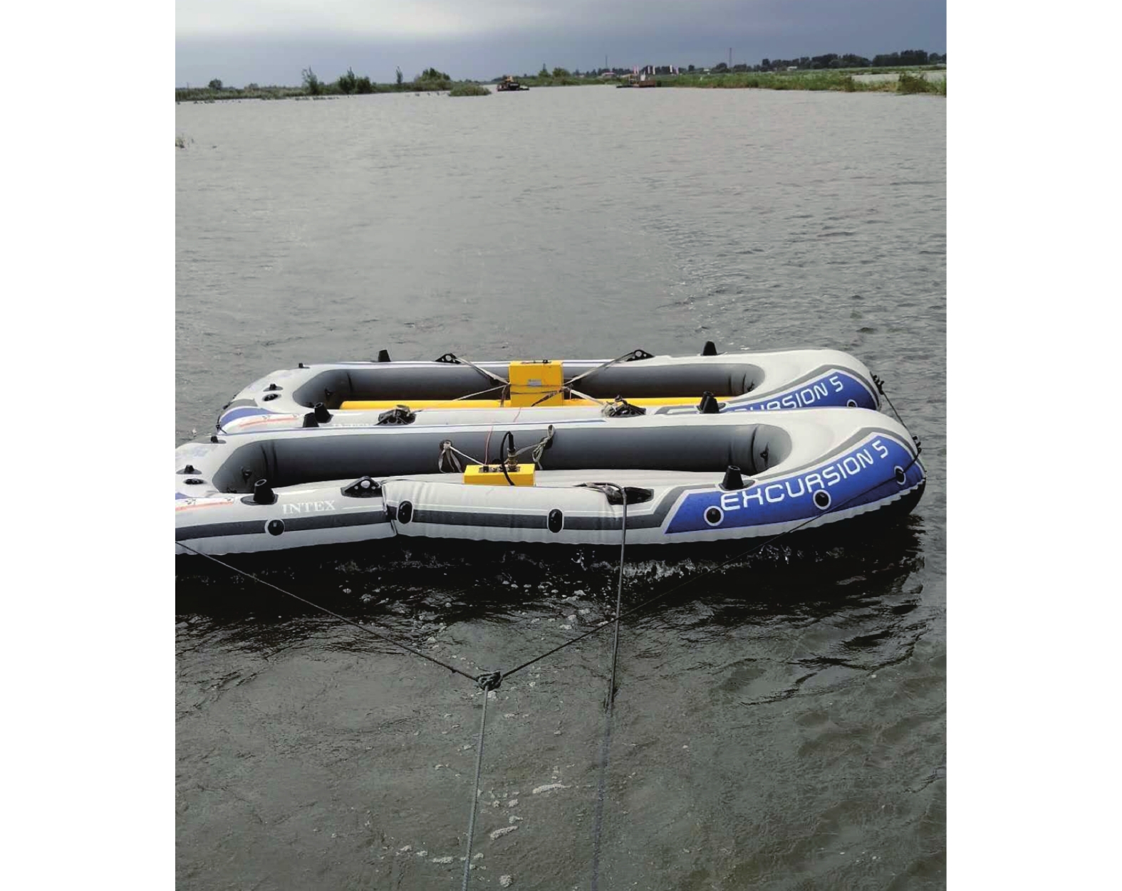
Figure 1.
Data acquisition site of double kayaked GPR water detection
-
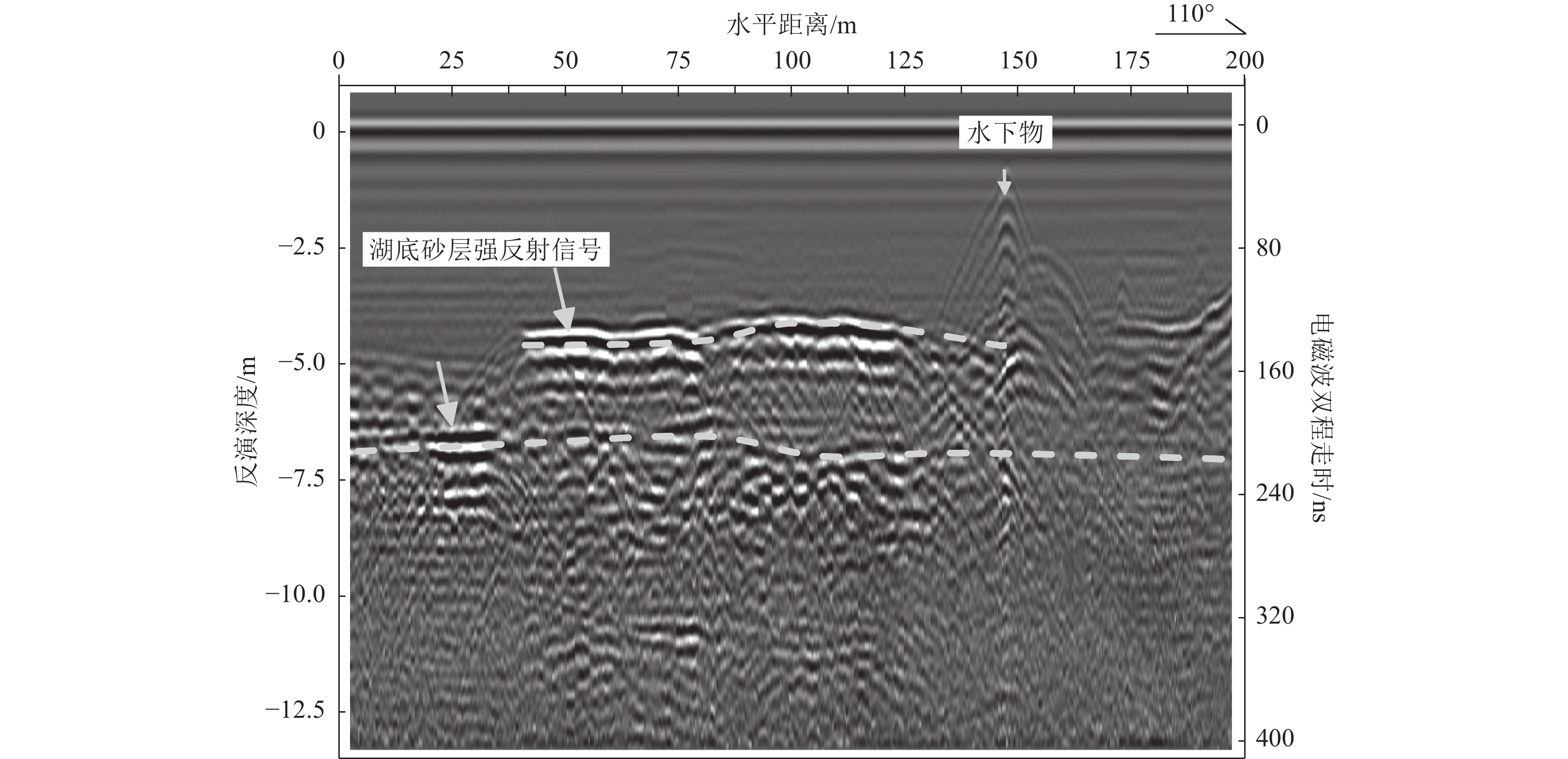
Figure 2.
The GPR time profile of underwater sand laye
-
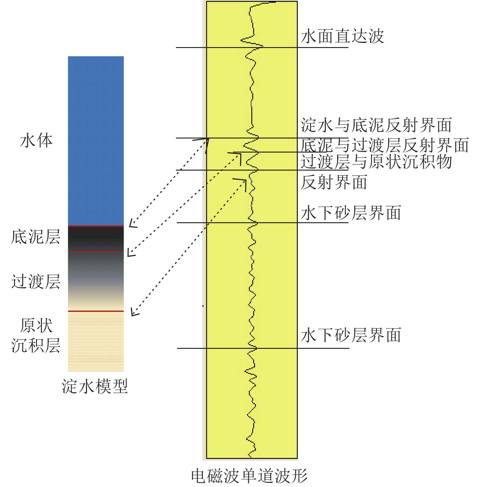
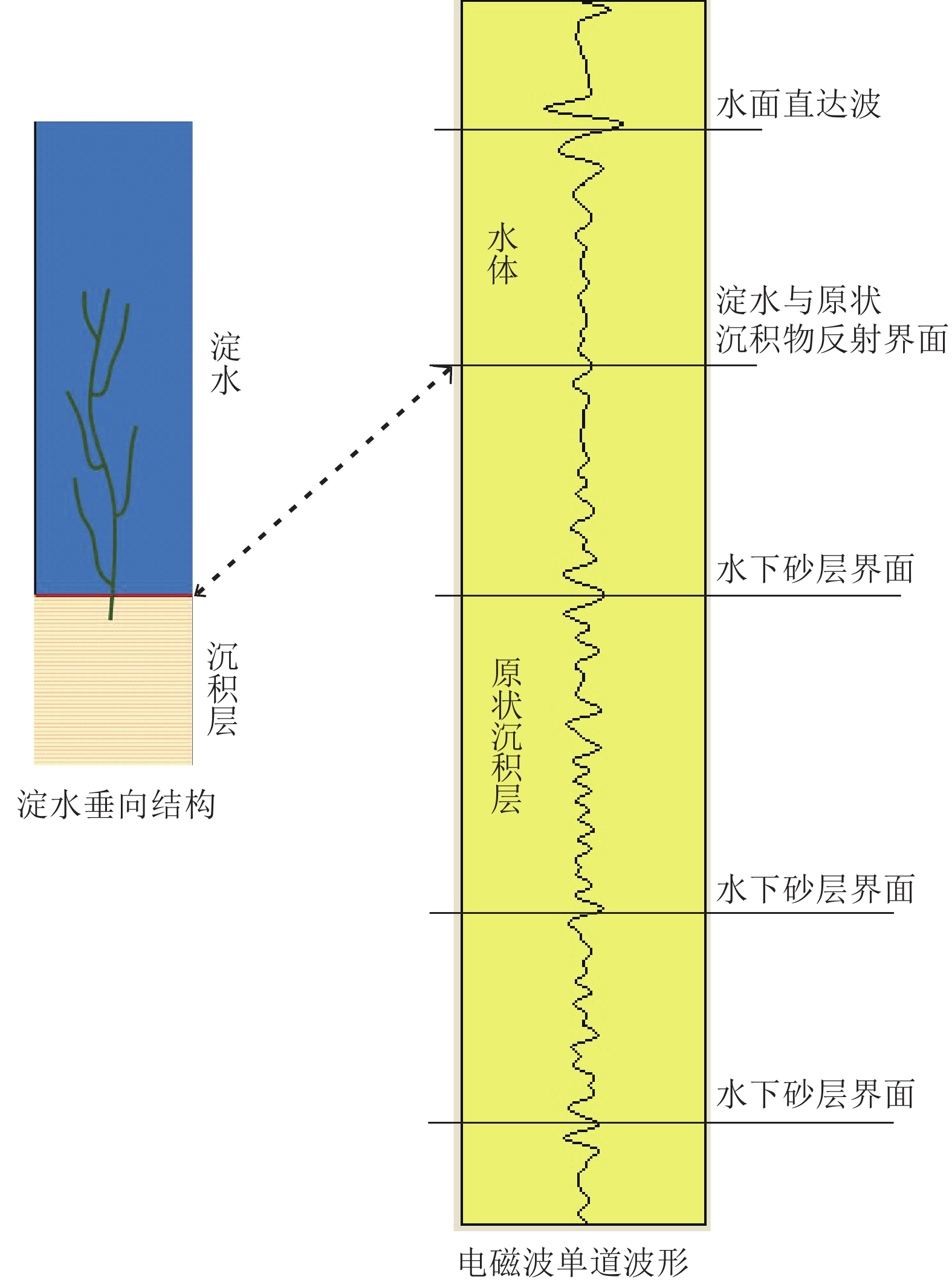
Figure 3.
Electromagnetic wave response of silt model
-
Figure 4.
Time profile of GPR water exploration in muddy area
-
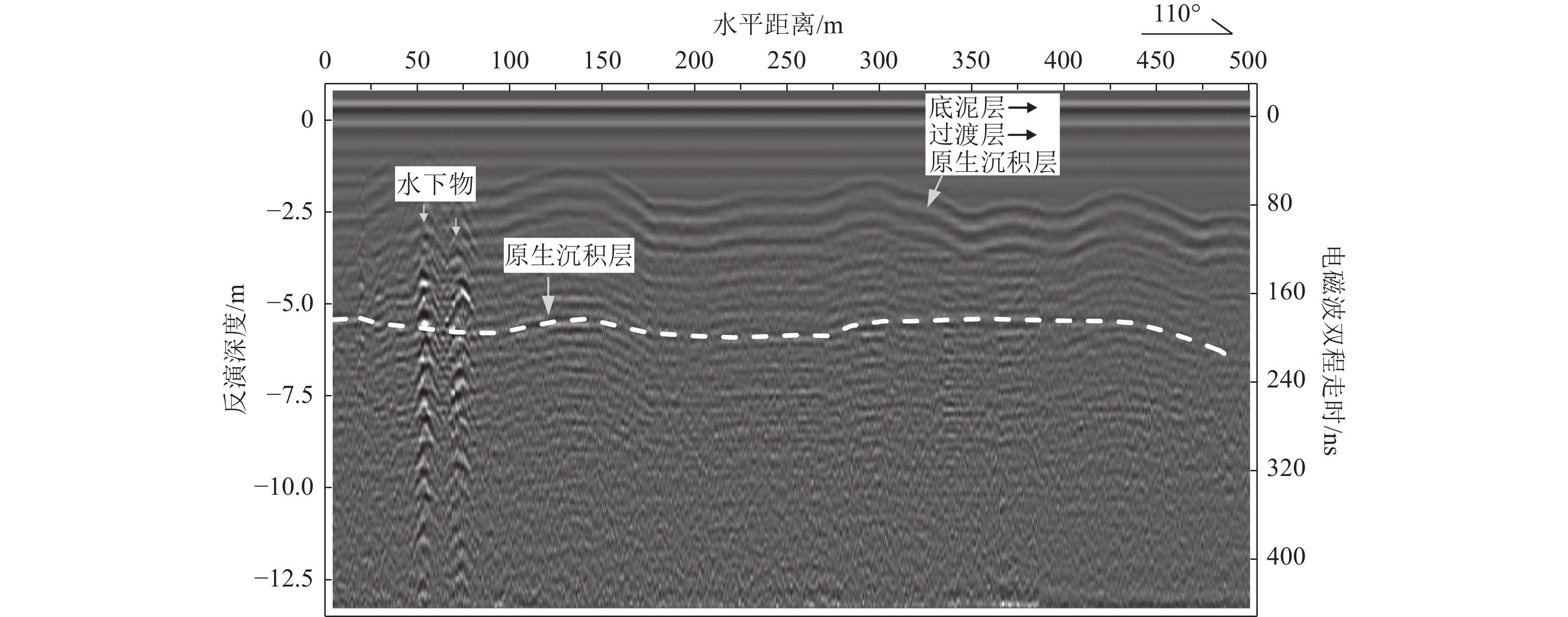
Figure 5.
Electromagnetic wave response of silt-free mod
-
Figure 6.
GPR profile of silt-free mode
-
Figure 7.
GPR profile of sand layers at the bottom of Baiyangdian Lake