
| China Geological Survey Chinese Academy of Geological Sciences | Host |
| 科学出版社 | Publish |
| Citation: |
RAN Tao, XU Ruge, ZHOU Hongfu, ZHANG Jinghua, CHEN Hao, WANG Yuke, SUN Jie, CUI Yanzong. 2024. Type, formation mechanism and distribution regularity of landslides in the deeply incised valley area of Yalong River Basin——A case study of Zituoxi–Malangcuo river section[J]. Geology in China, 51(2): 511-524. doi: 10.12029/gc20220329004

|
Type, formation mechanism and distribution regularity of landslides in the deeply incised valley area of Yalong River Basin——A case study of Zituoxi–Malangcuo river section
-
Abstract
This paper is the result of geological hazard survey engineering.
Objective The Yalong River Basin is an important base for forestry, animal husbandry, hydropower, energy, and minority communities in western China. It is of great significance to study the causes and distribution of landslides in the Yalong River Basin to formulate scientific disaster prevention and mitigation strategies and ensure stable economic and societal development.
Methods The Zituoxi–Malangcuo river section in a deeply incised valley area of the Yalong River Basin was used as the study area. Basic landslide data were obtained through high−resolution satellite remote sensing interpretation, InSAR analysis, and field investigation. The typical landslide types and their formation mechanisms were summarized and analyzed using an engineering geology analysis method, and the distribution regularity and dominant development range of landslides were revealed by means of GIS spatial analysis and statistical methods.
Results (1) A total of 606 landslides were identified in the study area, among which the number of landslides with an area of 104−105 square meters was the most, accounting for approximately 60 percent of the total, and the number of landslides with areas of 103−104 and 105−106 square meters were essentially equal, accounting for approximately 20 percent of the total respectively; (2) Landslides were divided into five main types, i.e. rainfall−induced type, structure−controlled type, excavation−induced type, river erosion type and water impoundment−induced type, according to the main controlling factors of landslides. The key mechanism responsible for the occurrence of landslides mainly including the weakening effect of rock and soil strength by rainfall and impounded water, the deterioration effect of rock structures and its mechanical properties by fault structures, and the release effect of the anti−sliding and supporting action at the front of slope caused by excavation and river erosion; (3) The dominant terrain ranges for landslide development were of elevation 2500−3500 m, slope angle 15°−35°, and slope aspect NE−E and S−W; (4) The soft metamorphic rock group composed of thin−bedded slate and silty slate was the dominant lithological group for development of landslides, while landslides in the magmatic rock group consisted of hard intrusive rocks such as granite and quartz diorite was the least; (5) the Kangdu fault, Qianbeinima fault, Zhusang fault, Tanggang fault, Huozezhari fault and Nieda fault were found having less impact on the development of landslides, however, landslides developed densely at both sides of the Mazishi fault, Chengzhang fault, Rangong fault and Jida−Milong−Muhui fault and at zones where these faults intersected in the downstream of the study area; (6) A negative correlation between the distribution of landslides and the distance to the river systems can be obviously seen, and a distance to the river systems of 0−0.5 km was found to be the dominant distance range of landslide development. The landslides were macroscopically concentrated along river valleys such as belts.
Conclusions The research results provide a significant scientific basis for understanding the causes and regularities of landslides in the deep incised valley of the Yalong River, and preventing and controlling the risk of geohazard chains in the river basin.
-

-
References
[1] Azañón J M, Azor A, Pérez−Peña J V, Carrillo J M. 2005. Late Quaternary large−scale rotational slides induced by river incision: The Arroyo de Gor area (Guadix basin, SE Spain)[J]. Geomorphology, 69: 152−168. doi: 10.1016/j.geomorph.2004.12.007 [2] Bai Yongjian, Tie Yongbo, Ni Huayong, Li Minghui. 2014. Temporal spatial distribution and environment pregnant of geohazards in Xianshui River of Sichuan, China[J]. Journal of Catastrophology, 29(4): 69−75 (in Chinese with English abstract). [3] Chang Xiaojun, Wei Lunwu, Wang Dewei. 2009. Distribution characteristics and influencing factors of geological hazards in Yalong River basin[J]. Journal of Catastrophology, 24(3): 83−88 (in Chinese with English abstract). [4] Chen Chunli, He Kai, Li Tonglu. 2014. Research on the mechanism of the ancient landslide resurrection triggered by slope toe excavation[J]. Northwestern Geology, 47(1): 255−260 (in Chinese with English abstract). [5] Dai F C, Xu C, Yao X, Xu L, Tu X B, Gong Q M. 2011. Spatial distribution of landslides triggered by the 2008 Ms 8.0 Wenchuan earthquake, China[J]. Journal of Asian Earth Sciences, 40: 883−895. doi: 10.1016/j.jseaes.2010.04.010 [6] Dai Fuchu, Deng Jianhui. 2020. Development characteristics of landslide hazards in Three−Rivers Basin of southeast Xizang Plateau[J]. Advanced Engineering Sciences, 52(5): 3−15 (in Chinese with English abstract). [7] Dai Keren, Tie Yongbo, Xu Qiang, Feng Ye, Zhuo Guanchen, Shi Xianlin. 2020. Early identification of potential landslide geohazards in alpine−canyon terrain based on SAR interferometry—A case study of the middle section of Yalong River[J]. Journal of Radars, 9(3): 554−568 (in Chinese with English abstract). [8] Deng Jianhui, Gao Yunjian, Yu Zhiqiu, Xie Heping. 2019. Analysis on the formation mechanism and process of Baige landslides damming the upper reach of Jinsha River, China[J]. Advanced Engineering Sciences, 51(1): 9−16 (in Chinese with English abstract). [9] Ding Jun, Ni Shijun, Wei Lunwu, Zhang Chengjiang, Lai Shaomin, Zheng Wanmo. 2005. Thinking on urban environmental geological survey in southwest China[J]. Sedimentary Geology and Tethyan Geology, 25(4): 108−110 (in Chinese with English abstract). [10] Fan Lei, Zhang Qi. 2016. Occurrence and distribution characteristics of landslides at Suwalong−Benzilan along Jinsha River[J]. Journal of Yangtze River Scientific Research Institute, 33(3): 38−41 (in Chinese with English abstract). [11] Huang Runqiu. 2007. Large−scale landslides and their sliding mechanisms in China since the 20th century[J]. Chinese Journal of Rock Mechanics and Engineering, 26(3): 433−454 (in Chinese with English abstract). [12] Huang Runqiu. 2009. Mechanism and geomechanical modes of landslide hazards triggered by Wenchuan 8.0 earthquake[J]. Chinese Journal of Rock Mechanics and Engineering, 28(6): 1239−1249 (in Chinese with English abstract). [13] Jin Yanli, Dai Fuchu. 2007. Analysis of loess slope stability due to groundwater rise[J]. Journal of Engineering Geology, 15(5): 599−606 (in Chinese with English abstract). [14] Leng Lun. 2000. Mountain collapse and dam−break flood in Yalong River[J]. Journal of China Hydrology, 20(3): 46−50 (in Chinese). [15] Liang Ruifeng, Yang Min, Yang Shuancheng, He Zihao. 2016. Distribution characteristics and influencing factors analysis of geological disasters in Kala section along Yalong River[J]. Pearl River, 37(11): 13−17 (in Chinese with English abstract). [16] Liu Caihua, Xu Jian, Cao Chuanlin, Chen Congxin, Feng Xiating. 2005. Analysis of bedding−slip failure mechanism of rock slope due to hydraulic drive[J]. Chinese Journal of Rock Mechanics and Engineering, 24(19): 131−135 (in Chinese with English abstract). [17] Liu Chuanzheng, Lü Jietang, Tong Liqiang, Chen Hongqi, Liu Qiuqiang, Xiao Ruihua, Tu Jienan. 2019. Research on glacial/rockfall−landslide−debris flows in Sedongpu basin along Yarlung Zangbo River in Xizang[J]. Geology in China, 46(2): 219−234 (in Chinese with English abstract). [18] Liu Xinghong, Yao Xin, Yu Kaibing, Dai Fuchu, Wang Shifeng, Yao Jiaming. 2020. Remote sensing integrated identification of geological hazards in the Batang−Mangkang section of the Sichuan−Xizang highway[J]. Advanced Engineering Sciences, 52(6): 49−60 (in Chinese with English abstract). [19] Liu Zhe. 2015. Hazard Assessment of Geological Disasters in Maidilong–Kala Section of Yalong River Basin Based on GIS[D]. Chengdu: Chengdu University of Technology (in Chinese with English abstract). [20] Lu Haifeng, Chen Congxin, Yuan Conghua, Yu Hongdan, Shen Qiang. 2010. Analysis of failure mechanism of Badong red bed soft rock gently inclined bedding slope[J]. Chinese Journal of Rock Mechanics and Engineering, 29(S2): 3569−3577 (in Chinese with English abstract). [21] Lu Huiyan, Li Weile, Xu Qiang, Dong Xiujun, Dai Cong, Wang Dong. 2019. Early detection of landslides in the upstream and downstream areas of the Baige landslide, the Jinsha River based on optical remote sensing and InSAR technologies[J]. Geomatics and Information Science of Wuhan University, 44(9): 1342−1354 (in Chinese with English abstract). [22] Ni Huayong, Chen Xuyu, Zhou Wei, Wang Dewei, Tang Yeqi. 2013. Formation and characteristics of gully−type debris flow on hilly plateau planes with cold climate and high altitude—A case study of the Zhusang scenic spot in Yajiang County of Sichuan Province[J]. Bulletin of Soil and Water Conservation, 33(1): 211−215 (in Chinese with English abstract). [23] Ni Huayong, Wang Dewei, Chen Xuyu, Tang Yeqi. 2015. Formation characteristics and stability assessment of geological hazards in Yajiang City, Sichuan Province[J]. Geoscience, 29(2): 474−480 (in Chinese with English abstract). [24] Pan Guitang, Ren Fei, Yin Fuguang, Wang Liquan, Wang Baodi, Wang Dongbing, An Xianyin, Tang Yuan, Liu Han, Wang Qiyu, Pang Weihua, Xu Bo. 2020. Key zones of oceanic plate geology and Sichuan−Xizang Railway Project[J]. Earth Science, 45(7): 2293−2304 (in Chinese with English abstract). [25] Peng Jianbing, Ma Runyong, Lu Quanzhong, Li Xi'an, Shao Tiequan. 2004. Geological hazards effects of uplift of Qinghai−Xizang Plateau[J]. Advance in Earth Sciences, 19(3): 457−466 (in Chinese with English abstract). [26] Ran Tao, Zhou Hongfu, Xu Wei, Li Qiaoxue, Zou Linzhi, Zhang Chuanlei. 2020. Research on the instability modes, failure mechanisms and preventive measures of representative rock slopes within Ya'an–Luding section of the western Sichuan transportation corridor[J]. Journal of Natural Disasters, 29(4): 200−212 (in Chinese with English abstract). [27] Wang Dewei, Ni Huayong, Chen Xuyu, Tang Yeqi. 2017. Dataset of geological hazards survey in Yajiang County, Sichuan Province in 2010[J]. Geology in China, 44(S1): 82−87 (in Chinese with English abstract). [28] Wang Zhihua. 2012. Remote Sensing for Landslide[M]. Beijing: Science Press (in Chinese). [29] Wen Baoping, Shen Jian, Tan Jianmin. 2008. The influence of water on the occurrence of Qianjiangping landslide[J]. Hydrogeology & Engineering Geology, 35(3): 12−18 (in Chinese with English abstract). [30] Wu Yunbo. 2015. Development Regularity and Formation Mechanism of Landslides in Kala area of Yalong River[D]. Chengdu: Chengdu University of Technology (in Chinese with English abstract). [31] Xiao Shirong, Hu Zhiyu, Lu Shusheng, Ming Chengtao, Chen Deqian. 2013. Classification of reservoir−triggered landslides in Three Gorges reservoir area[J]. Journal of Yangtze River Scientific Research Institute, 30(11): 39−44 (in Chinese with English abstract). [32] Xu Q, Shang Y J, van Asch T, Wang S T, Zhang Z Y, Dong X J. 2012. Observations from the large, rapid Yigong rock slide−debris avalanche, southeast Xizang[J]. Canadian Geotechnical Journal, 49(5): 589−606. doi: 10.1139/t2012-021 [33] Xu Qiang, Zheng Guang, Li Weile, He Chaoyang, Dong Xiujun, Guo Chen, Feng Wenkai. 2018. Study on successive landslide damming events of Jinsha River in Baige Village on October 11 and November 3, 2018[J]. Journal of Engineering Geology, 26(6): 1534−1551 (in Chinese with English abstract). [34] Yang Zhihua, Wu Ruian, Guo Changbao, Zhang Yongshuang, Lan Hengxing, Ren Sanshao, Yan Yiqiu. 2022. Geo-hazard effects and typical landslide characteristics of the Batang fault zone in the western Sichuan[J]. Geology in China, 49(2): 355−368(in Chinese with English abstract). [35] Yi Zhijian, Huang Runqiu, Wu Haiyan, He Shunxun, Yang Jian, Zhou Longshou. 2016. Research on formation mechanism of Tanggudong landslide[J]. Journal of Engineering Geology, 24(6): 1072−1079 (in Chinese with English abstract). [36] Yin Yueping. 2000. Characteristics and mitigation of Yigong rapid huge landslide in Bomi, Xizang[J]. Hydrogeology and Engineering Geology, 27(4): 1072−1079 (in Chinese with English abstract). [37] Zhang Peizhen. 2008. Present tectonic deformation, strain distribution and deep dynamic processes of the western Sichuan region, eastern margin of Xizang Plateau[J]. Science in China (Series D: Earth Sciences), 38(9): 1041−1056 (in Chinese). [38] Zhang Yongshuang, Ba Renji, Ren Sanshao, Li Zongliang. 2020. An analysis of geo−mechanism of the Baige landslide in Jinsha River, Xizang[J]. Geology in China, 47(6): 1637−1645 (in Chinese with English abstract). [39] Zhang Yongshuang, Guo Changbao, Yao Xin, Yang Zhihua, Wu Ruian, Du Guoliang. 2016. Research on the geohazard effect of active fault on the eastern margin of the Xizang Plateau[J]. Acta Geoscientica Sinica, 37(3): 277−286 (in Chinese with English abstract). [40] Zhang Zhuoyuan, Wang Shitian, Wang Lansheng. 1994. Analysis Principles of Engineering Geology (2nd Edition)[M]. Beijing: Geological Publishing House (in Chinese). [41] Zheng Wanmo, Tang Xiaoping, Wang Quan. 1997. Characteristics of the geological hazards in the town area of Yajiang County[J]. Journal of Geological Hazards and Environment Preservation, 8(3): 13−20 (in Chinese with English abstract). [42] 白永健, 铁永波, 倪化勇, 李明辉. 2014. 鲜水河流域地质灾害时空分布规律及孕灾环境研究[J]. 灾害学, 29(4): 69−75. [43] 常晓军, 魏伦武, 王德伟. 2009. 雅砻江流域地质灾害分布特征及其影响因素分析[J]. 灾害学, 24(3): 83−88. [44] 陈春利, 贺凯, 李同录. 2014. 坡脚开挖诱发古滑坡复活的机制分析[J]. 西北地质, 47(1): 255−260. [45] 戴福初, 邓建辉. 2020. 青藏高原东南三江流域滑坡灾害发育特征[J]. 工程科学与技术, 52(5): 3−15. [46] 戴可人, 铁永波, 许强, 冯也, 卓冠晨, 史先琳. 2020. 高山峡谷区滑坡灾害隐患InSAR早期识别—以雅砻江中段为例[J]. 雷达学报, 9(3): 554−568. [47] 邓建辉, 高云建, 余志球, 谢和平. 2019. 堰塞金沙江上游的白格滑坡形成机制与过程分析[J]. 工程科学与技术, 51(1): 9−16. [48] 丁俊, 倪师军, 魏伦武, 张成江, 赖绍民, 郑万模. 2005. 西南地区城市环境地质调查工作的思考[J]. 沉积与特提斯地质, 25(4): 108−110. [49] 范雷, 张琪. 2016. 金沙江苏洼龙―奔子栏河段滑坡灾害发育分布规律[J]. 长江科学院院报, 33(3): 38−41. [50] 黄润秋. 2007. 20世纪以来中国的大型滑坡及其发生机制[J]. 岩石力学与工程学报, 26(3): 433−454. [51] 黄润秋. 2009. 汶川8.0级地震触发崩滑灾害机制及其地质力学模式[J]. 岩石力学与工程学报, 28(6): 1239−1249. [52] 金艳丽, 戴福初. 2007. 地下水位上升下黄土斜坡稳定性分析[J]. 工程地质学报, 15(5): 599−606. doi: 10.3969/j.issn.1004-9665.2007.05.004 [53] 冷伦. 2000. 雅砻江垮山堵江及溃泄洪水[J]. 水文, 20(3): 46−50. [54] 梁瑞锋, 杨敏, 杨栓成, 赫子皓. 2016. 雅砻江流域卡拉段地质灾害分布特征与影响因素分析[J]. 人民珠江, 37(11): 13−17. [55] 刘才华, 徐健, 曹传林, 陈从新, 冯夏庭. 2005. 岩质边坡水力驱动型顺层滑移破坏机制分析[J]. 岩石力学与工程学报, 24(19): 131−135. [56] 刘传正, 吕杰堂, 童立强, 陈红旗, 刘秋强, 肖锐铧, 涂杰楠. 2019. 雅鲁藏布江色东普沟崩滑−碎屑流堵江灾害初步研究[J]. 中国地质, 46(2): 219−234. doi: 10.12029/gc20190201 [57] 刘星洪, 姚鑫, 於开炳, 戴福初, 王世锋, 姚佳明. 2020. 川藏高速巴塘―芒康段地质灾害遥感综合早期识别研究[J]. 工程科学与技术, 52(6): 49−60. [58] 刘哲. 2015. 基于GIS的雅砻江流域麦地龙—卡拉段地质灾害危险性评价[D]. 成都: 成都理工大学. [59] 卢海峰, 陈从新, 袁从华, 于洪丹, 沈强. 2010. 巴东组红层软岩缓倾顺层边坡破坏机制分析[J]. 岩石力学与工程学报, 29(增2): 3569−3577. [60] 陆会燕, 李为乐, 许强, 董秀军, 代聪, 王栋. 2019. 光学遥感与InSAR结合的金沙江白格滑坡上下游滑坡隐患早期识别[J]. 武汉大学学报(信息科学版), 44(9): 1342−1354. [61] 倪化勇, 陈绪钰, 周维, 王德伟, 唐业旗. 2013. 高寒高海拔山原区沟谷型泥石流成因与特征—以四川省雅江县祝桑景区为例[J]. 水土保持通报, 33(1): 211−215. [62] 倪化勇, 王德伟, 陈绪钰, 唐业旗. 2015. 四川雅江县城地质灾害发育特征与稳定性评价[J]. 现代地质, 29(2): 474−480. [63] 潘桂棠, 任飞, 尹福光, 王立全, 王保弟, 王冬兵, 安显银, 唐渊, 刘函, 王启宇, 庞维华, 徐波. 2020. 洋板块地质与川藏铁路工程地质关键区带[J]. 地球科学, 45(7): 2293−2304. [64] 彭建兵, 马润勇, 卢全中, 李喜安, 邵铁全. 2004. 青藏高原隆升的地质灾害效应[J]. 地球科学进展, 19(3): 457−466. doi: 10.3321/j.issn:1001-8166.2004.03.018 [65] 冉涛, 周洪福, 徐伟, 李巧学, 邹林志, 张传磊. 2020. 川西交通廊道雅安—泸定段典型岩质边坡失稳模式、破坏机理及防治措施[J]. 自然灾害学报, 29(4): 200−212. [66] 王德伟, 倪化勇, 陈绪钰, 唐业旗. 2017. 2010年四川省雅江县地质灾害调查数据集[J]. 中国地质, 44(增刊1): 82−87. [67] 王治华. 2012. 滑坡遥感[M]. 北京: 科学出版社. [68] 文宝萍, 申健, 谭建民. 2008. 水在千将坪滑坡中的作用机理[J]. 水文地质工程地质, 35(3): 12−18. [69] 武运泊. 2015. 雅砻江卡拉地区滑坡发育规律与成因机制分析[D]. 成都: 成都理工大学. [70] 肖诗荣, 胡志宇, 卢树盛, 明成涛, 陈德乾. 2013. 三峡库区水库复活型滑坡分类[J]. 长江科学院院报, 30(11): 39−44. doi: 10.3969/j.issn.1001-5485.2013.11.009 [71] 许强, 郑光, 李为乐, 何朝阳, 董秀军, 郭晨, 冯文凯. 2018. 2018年10月和11月金沙江白格两次滑坡−堰塞堵江事件分析研究[J]. 工程地质学报, 26(6): 1534−1551. [72] 杨志华,吴瑞安,郭长宝,张永双,兰恒星,任三绍,闫怡秋. 2022. 川西巴塘断裂带地质灾害效应与典型滑坡发育特征[J]. 中国地质, 49(2): 355−368. [73] 易志坚, 黄润秋, 吴海燕, 何顺勋, 杨建, 周龙寿. 2016. 唐古栋滑坡成因机制研究[J]. 工程地质学报, 24(6): 1072−1079. [74] 殷跃平. 2000. 西藏波密易贡高速巨型滑坡特征及减灾研究[J]. 水文地质工程地质, 27(4): 1072−1079. [75] 张培震. 2008. 青藏高原东缘川西地区的现今构造变形、应变分配与深部动力过程[J]. 中国科学(D辑:地球科学), 38(9): 1041−1056. [76] 张永双, 巴仁基, 任三绍, 李宗亮. 2020. 中国西藏金沙江白格滑坡的地质成因分析[J]. 中国地质, 47(6): 1637−1645. doi: 10.12029/gc20200603 [77] 张永双, 郭长宝, 姚鑫, 杨志华, 吴瑞安, 杜国梁. 2016. 青藏高原东缘活动断裂地质灾害效应研究[J]. 地球学报, 37(3): 277−286. [78] 张倬元, 王士天, 王兰生. 1994. 工程地质分析原理(第二版)[M]. 北京: 地质出版社. [79] 郑万模, 唐小平, 王泉. 1997. 雅砻江畔雅江县城区地质灾害特征及其防治对策[J]. 地质灾害与环境保护, 8(3): 13−20. -
Access History

Figures(13)
Tables(1)

Export File
Citation
RAN Tao, XU Ruge, ZHOU Hongfu, ZHANG Jinghua, CHEN Hao, WANG Yuke, SUN Jie, CUI Yanzong. 2024. Type, formation mechanism and distribution regularity of landslides in the deeply incised valley area of Yalong River Basin——A case study of Zituoxi–Malangcuo river section[J]. Geology in China, 51(2): 511-524. doi: 10.12029/gc20220329004
Format
Content
 DownLoad:


-
Figure 1.
Traffic location map of the study area
-
Figure 2.
Background map of landslides in the study area
-
Figure 3.
Remote sensing interpretation map of landslides in the study area
-
Figure 4.
Average annual ground surface deformation rate and identified potential landslides in the study area
-
Figure 5.
Spatial distribution of landslides in the study area
-
Figure 6.
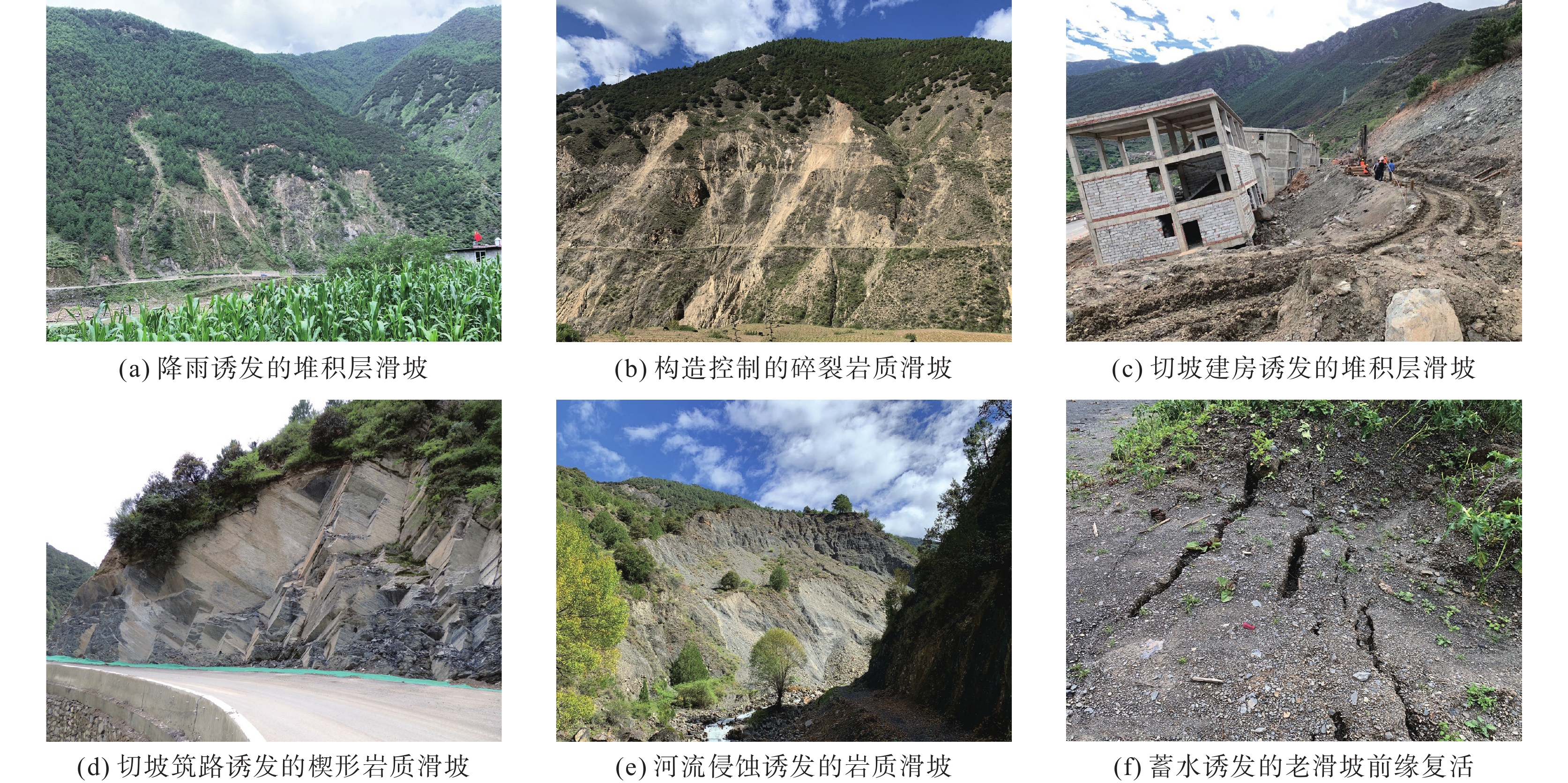
Representative types of landslides in the study area
-
Figure 7.
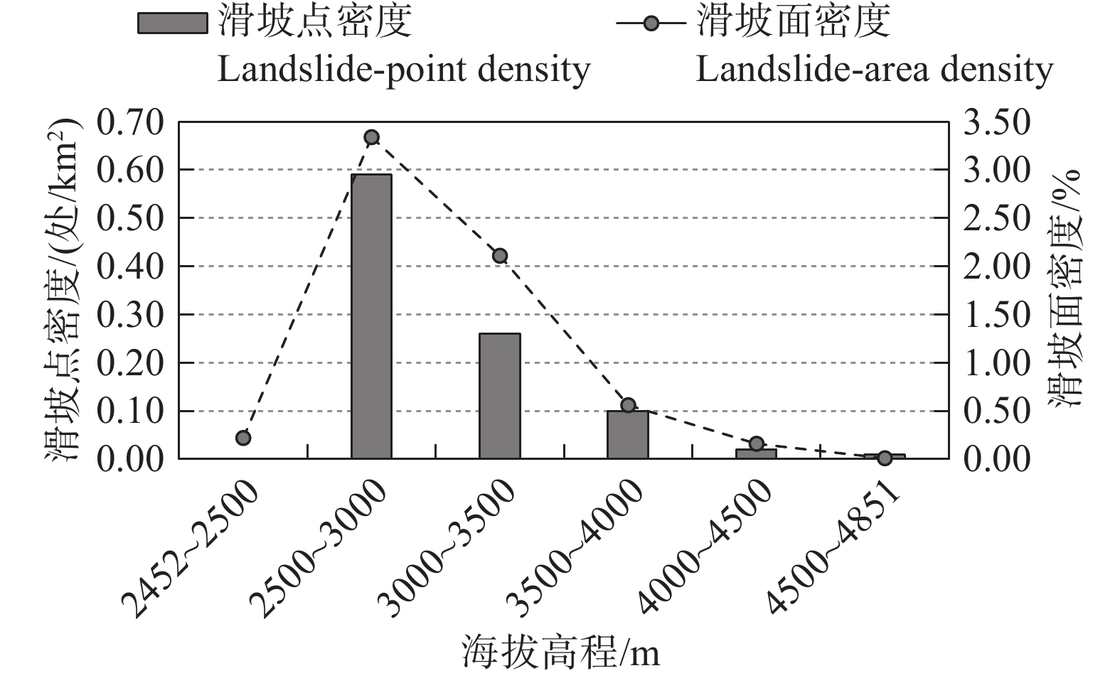
Landslide−point density and landslide−area density versus elevation
-
Figure 8.
Landslide−point density and landslide−area density versus slope angle
-
Figure 9.
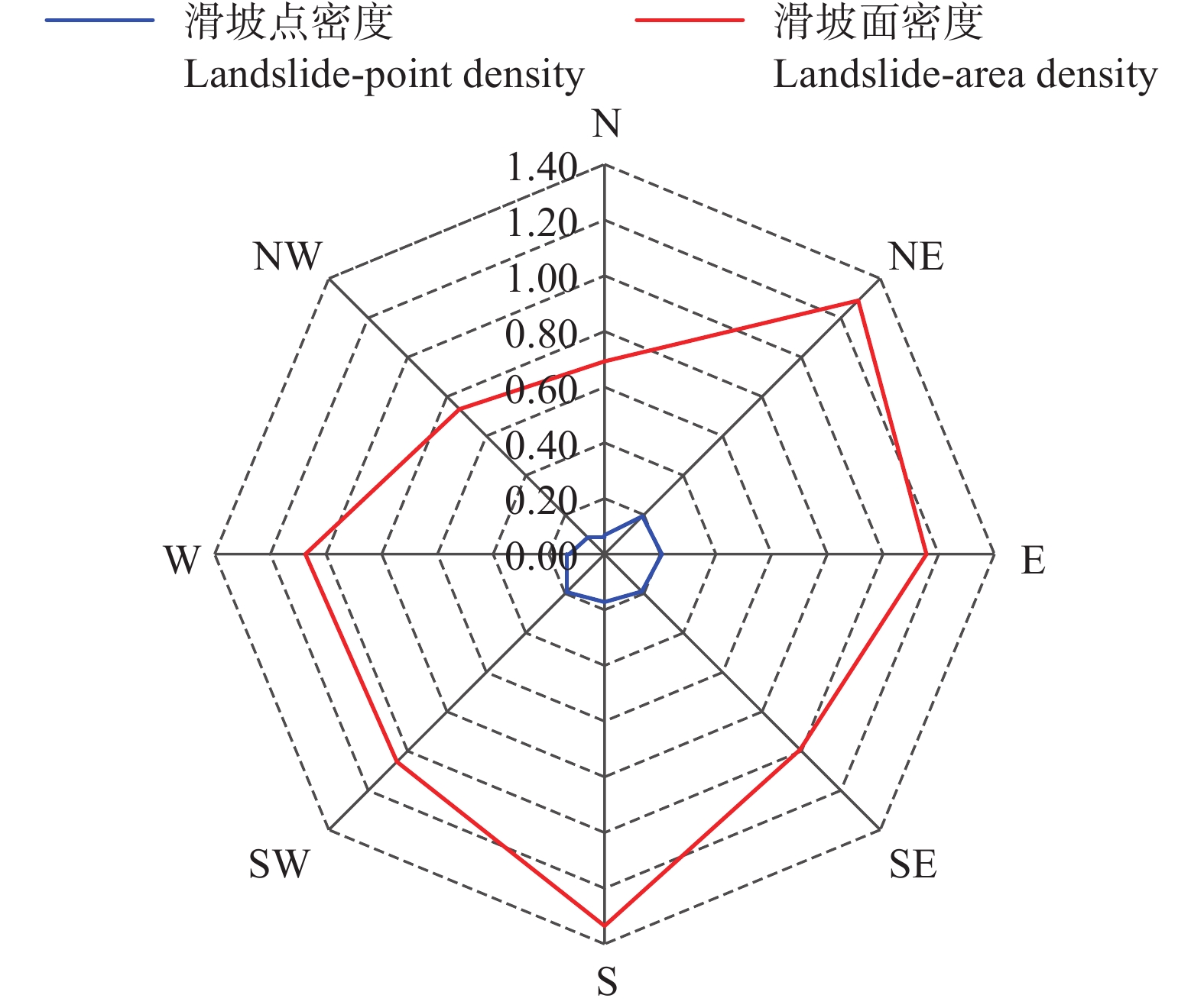
Landslide−point density and landslide−area density versus slope aspect
-
Figure 10.
Landslide−point density and landslide−area density versus lithological group
-
Figure 11.
Landslide−point density and landslide−area density versus distance to fault
-
Figure 12.
Landslide−point density and landslide−area density versus 1 km buffer zone of the faults
-
Figure 13.
Landslide−point density and landslide−area density versus distance to river