
| China Geological Survey Chinese Academy of Geological Sciences | Host |
| 科学出版社 | Publish |
| Citation: |
ZHAO Baoqiang, ZHANG Zhaoyi, WANG Kebing, WANG Chuan, XU Yongli, GENG Xiaolei. 2020. 1∶50 000 Geological Map Spatial Database of Guye Map-sheet, Tangshan Map-sheet and Fangezhuangmeikuang Map-sheet, Hebei Province[J]. Geology in China, 47(S1): 112-124. doi: 10.12029/gc2020Z111

|
1∶50 000 Geological Map Spatial Database of Guye Map-sheet, Tangshan Map-sheet and Fangezhuangmeikuang Map-sheet, Hebei Province
-
Abstract
In accordance with the ‘Standard of Digital Geological Map Spatial Database’ (DD 2006–06), the 1∶50 000 Geological Map Spatial Database of Guye Map-sheet (J50E002018), Tangshan Map-sheet (J50E003017) and Fangezhuangmeikuang Map-sheet (J50E003018), Hebei Province was completed by fully collecting previous geological data, and conducting 1∶50 000 regional geological survey of Guye Map-sheet, Tangshan Map-sheet and Fangezhuangmeikuang Map-sheet in and around Tangshan City, with 1∶50 000 geological maps compiled. Data was collected by means of remote sensing interpretation, field digital mapping, Quaternary drilling, manual shallow drilling and shallow seismic profiles. The database includes four datasets, i.e. basic element, comprehensive element, object and independent element, of which the basic element dataset includes 651 pieces of geopolygons (Quaternary, sedimentary rocks, metamorphic rocks, intrusive rocks and other area entities), 1428 geological boundaries, 194 attitudes, 562 photos, 70 data for dating (zircon U–Pb, 14C and OSL dating), and five data pertaining to Quaternary drill holes; the comprehensive element dataset consists primarily of standard frame (internal map frame); the object dataset includes 57 data on sedimentary lithostratigraphic units (including the Quaternary), two data applied to intrusive lithochronological units, faults, dikes, water region and map-sheet basic information; the independent element dataset comprises primarily angular maps, with no attributes added. The database was constructed under a stringent quality control system throughout the entire process, which ensures the authenticity, reliability and accuracy of data, thus providing reliable geological support for sustainable economic development, urban planning, construction, ecological preservation and major engineering projects in corresponding regions.
-

-
References
[1] 胥勤勉, 袁桂邦, 辛后田, 潘桐. 2014. 平原区1∶5 万区域地质调查在生态文明建设中的作用−以渤海湾北岸为例[J]. 地质调查与研究, 37(2): 85−89. doi: 10.3969/j.issn.1672-4135.2014.02.002 [2] 吴忱. 1984. 河北平原的地面古河道[J]. 地理学报, 39(3): 268−276. doi: 10.3321/j.issn:0375-5444.1984.03.007 [3] 吴忱. 2001. 华北山地的水系变迁与新构造运动[J]. 华北地震科学, 19(4): 1−6. doi: 10.3969/j.issn.1003-1375.2001.04.001 [4] 大港油田地质研究所, 海洋石油勘探局地质研究院, 同济大学海洋地质研究所. 1985. 滦河冲积扇—三角洲沉积体系[M]. 北京: 地质出版社, 1–158. [5] 高善明. 1985. 滦河冲积扇结构和沉积环境[J]. 地理研究, 4(1): 54−63. [6] 李从先, 王强, 范代读. 2013. 海洋三角洲[C]//冯增昭. 中国沉积学. 北京: 石油工业出版社, 812–905. [7] 胡云壮, 张金起, 白耀楠, 夏雨波, 王强. 2014. 3.45 Ma以来滦河冲积扇中部唐山TD1 孔记录的区域构造和气候演化[J]. 古地理学报, 16(2): 249−262. doi: 10.7605/gdlxb.2014.02.023 [8] 康庄, 王永力, 毛朝霞. 2012. 数字填图系统成果地质图空间数据库的特点与质量检查方法[J]. 地质与资源, 21(2): 256−260. doi: 10.3969/j.issn.1671-1947.2012.02.014 [9] 庞健峰, 丁孝忠, 韩坤英, 曾勇, 陈安蜀, 张艳玲, 张庆合, 姚冬生. 2017. 1∶100 万中华人民共和国地质图空间数据库[J]. 中国地质, 44(S1): 8−18. [10] 张源, 赵凯, 李海涛, 尤冰, 王永波, 王世雄. 2018. 雄安新区白洋淀流域平原区1: 50 000水文地质数据集[J]. 中国地质, 45(S2): 1−12. doi: 10.12029/gc2018Z201 [11] 赵保强, 张兆祎, 王克冰, 徐永利, 王川, 耿晓磊. 2020. 河北省古冶幅、唐山幅、范各庄煤矿幅1∶50 000 地质图空间数据库[DB/OL]. 地质科学数据出版系统. (2020-06-30). DOI: 10.35080/data.A.2020.P11. [1] Gao Shanming. 1985. Structures and sedimentary environments of the alluvial fan of the Luan River[J]. Geographical Research, 4(1): 54−63 (in Chinese with English abstract). [2] Geological Research Institute of Dagang Dagang Petroleum Field, Marine Petroleum Exploration Bureau, Marine Geology Institute of Tongji University. 1985. Luan River Alluvial Fan-delta Sedimentary System[M]. Beijing: Geological Publishing House, 1–158(in Chinese). [3] Hu Yunzhuang, Zhang Jinqi, Bai Yaonan, Xia Yubo, Wang Qiang. 2014. Records of regional tectonic and climatic evolution since 3. 45 Ma BP at Borehole TD1 of Tangshan in the middle part of Luanhe River fluvial fan[J]. Journal of Palaeogeography, 16(2): 249−262 (in Chinese with English abstract). [4] Kang Zhuang, Wang Yongli, Mao Chaoxia. 2012. The Digital Geological Mapping Achievement Spatial Database: Characteristics and examination[J]. Geology and Resources, 21(2): 256−260 (in Chinese with English abstract). [5] Li Congxian, Wang Qiang, Fan Daidu. 2013. Ocean delta[C]//Feng Zengzhao. Sedimentology of China. Beijing: Petroleum Industry Press, 812–905 (in Chinese). [6] Pang Jianfeng, Ding Jianzhong, Han Kunying, Zeng Yong, Chen Anshu, Zhang Yanling, Zhang Qinghe, Yao Dongsheng. 2017. The National 1∶1 000 000 Geological Map Spatial Database[J]. Geology in China, 44(S1): 10−23. [7] Wu Chen. 1984. Surface ancient channels in Hebei Plain[J]. Acta Geographica Sinica, 39(3): 268−276 (in Chinese with English abstract). [8] Wu Chen. 2001. Changes of river system and new tectonic movement in north China mountainous area[J]. North China Earthquake Sciences, 19(4): 1−6 (in Chinese with English abstract). [9] Xu Qinmian, Yuan Guibang, Xin Houtian, Pan Tong. 2014. Functions of 1∶50 000 Regional Geological Survey in EcologicalCivilization Construction: A Case Studyon Northern Coast of Bohai Bay[J]. Geological Survey and Research, 37(2): 85−89 (in Chinese with English abstract). [10] Zhang Yuan, Zhao Kai, Li Haitao, You Bing, Wang Yongbo, Wang Shixiong. 2018. Dataset of the 1∶50 000 Hydrogeological Map of the Plain Area of the Baiyangdian Lake Basin, Xiongan New Area[J]. Geology in China, 45(S2): 1−17. [11] Zhao Baoqiang, Zhang Zhaoyi, Wang Kebing, Xu Yongli, Wang Chuan, Geng Xiaolei. 2020.1∶50 000 Geological Map Spatial Database of Guye Map-sheet, Tangshan Map-sheet and Fangezhuangmeikuang Map-sheet, Hebei Province[DB/OL]. Geoscientific Data & Discovery Publishing System, (2020-06-30). DOI: 10.35080/data.A.2020.P11. -
Access History

Figures(4)
Tables(26)

Export File
Citation
ZHAO Baoqiang, ZHANG Zhaoyi, WANG Kebing, WANG Chuan, XU Yongli, GENG Xiaolei. 2020. 1∶50 000 Geological Map Spatial Database of Guye Map-sheet, Tangshan Map-sheet and Fangezhuangmeikuang Map-sheet, Hebei Province[J]. Geology in China, 47(S1): 112-124. doi: 10.12029/gc2020Z111
Format
Content
 DownLoad:


- Figure 1.
- Figure 2.
-
Figure 1.
Location of 1∶50 000 Guye map-sheet, Tangshan map-sheet and Fangezhuangmeikuang map-sheet, Hebei Province (modified from Hu YZ et al., 2014)
-
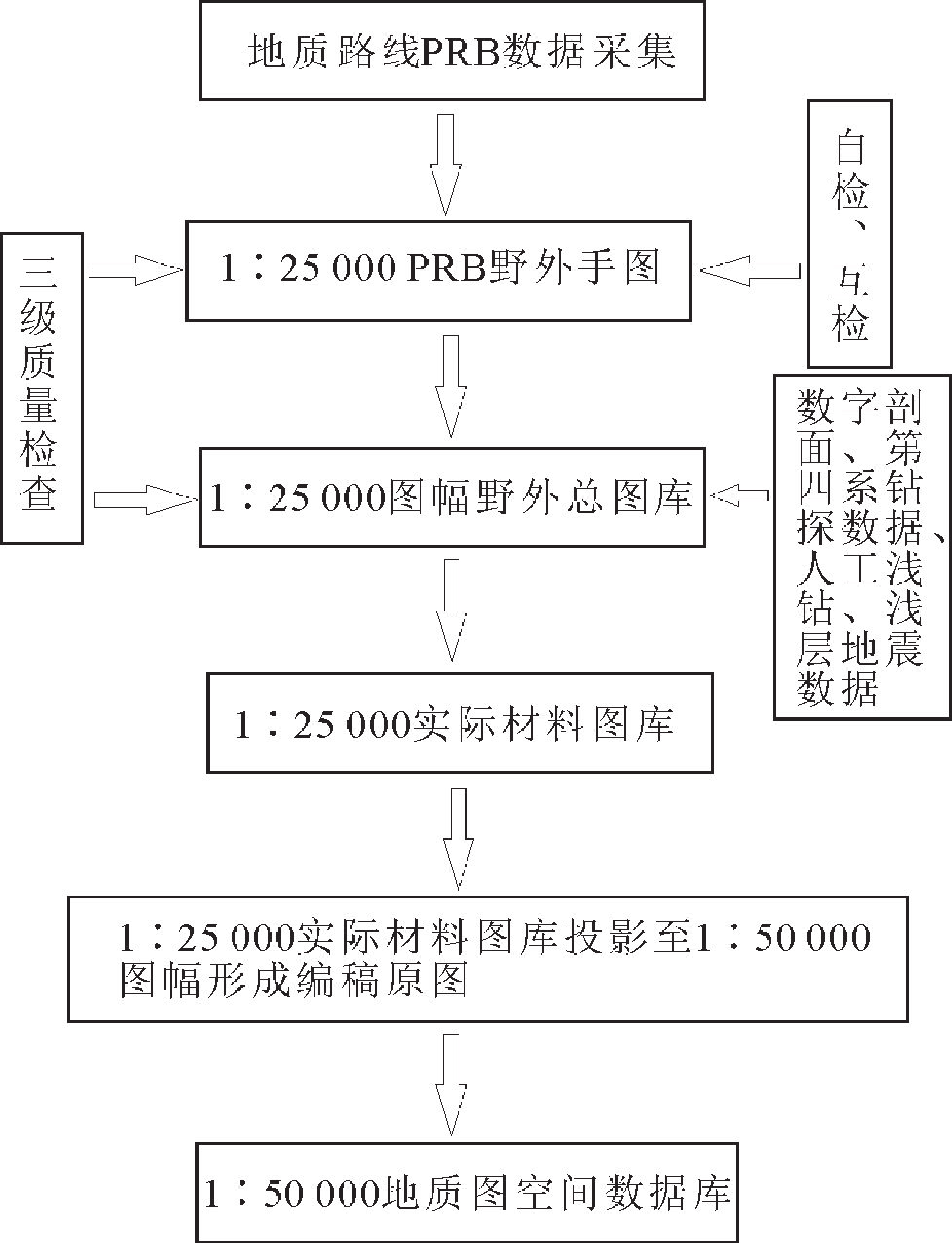
Figure 2.
Work flow of geological map spatial database