
| China Geological Survey Chinese Academy of Geological Sciences | Host |
| 科学出版社 | Publish |
| Citation: |
HUANG Meng, CHEN Xing, WANG Li, MA Qingyun. 2020. Database of the 1∶50 000 Geological Map of Huangzhuang, Tianjin[J]. Geology in China, 47(S1): 99-111. doi: 10.12029/gc2020Z110

|
Database of the 1∶50 000 Geological Map of Huangzhuang, Tianjin
-
Abstract
1∶50 000 geologic map of the Huangzhuang map-sheet (J50E004015), Tianjin was mapped by employing the Digital Geological Survey System (DGSS), and consequently a database was built by fully collecting and making use of existing geological data, as well as following industrial specifications. The database includes four datasets, i.e. a basic element, comprehensive element, object element and independent element, in total 23 different categories of data types, accumulating to a data size of 43.8 MB. Among them, there are 96 geological entities, 320 geological (boundaries) lines and 85 videos (photos), as well as nine samples of isotope dating, 10 boreholes and 13 sedimentary (volcanic) lithostratigraphic units. In the geologic map, the genetic type of the superficial deposit landform and its vertical geological structure, stratigraphic structure feature and lithofacies palaeogeographic evolution since the Late Pliocene, as well as the bedrock geological structure, and environmental engineering geological problems were all summarized; the methodology for the geological survey and innovative map presentation of the geologic map in the low coastal plain coverage area was explored simultaneously, which all play an exemplary role for regional geological survey in the coverage area. The database can provide detailed and basic geological data for geological environmental protection, natural resource management, in addition to hydrological, engineering and environmental geological surveying, thus supporting a sustainable development of an important national economic zone, major engineering construction, geological and ecological environmental protection, and urban planning.
-
Keywords:
- Tianjin /
- Huangzhuang Map Sheet /
- 1∶50 000 /
- database /
- low plain coverage /
- Quaternary /
- geological survey engineering
-

-
References
[1] Xu QM, Yuan GB, Yang JL, Xin HT, Yi L, Deng CL. 2017. Plio-Pleistocene magnetostratigraphy of northern Bohai Bay and its implications for tectonic events since ca. 2.0 Ma[J]. Journal of Geodynamics, 111: 1−14. doi: 10.1016/j.jog.2017.08.002 [2] Xu QM, Yang JL, Hu YZ, Yuan GB, Deng CL. 2018. Magnetostratigraphy of two deep boreholes in Southwestern Bohai Bay: tectonic implications and constraints on the ages of volcanic layers[J]. Quaternary Geochronology, 43: 102−114. doi: 10.1016/j.quageo.2017.08.006 [3] Xu QM, Meng LS, Yuan GB, Teng F, Xin HT, Sun XM. 2020. Transgressive wave- and tide-dominated barrier system and sea level rise since 8.2 ka in sediments in Northern Bohai Bay, China[J]. Geochronology, 352: 1−16. [4] Yang JL, Liang MY, Algeo TJ, Xu QM, Hu YZ, Yuan HF, Xiao GQ. 2020. Upper Miocene-Quaternary magnetostratigraphy and magnetic susceptibility from the Bohai Bay Basin (eastern China) and implications for regional volcanic and basinal subsidence history[J]. Palaeogeography, Palaeoclimatology, Palaeoecology, 538: 1−12. [5] 白晋娬, 牛修俊. 2010. 天津新生界固结特征与地面沉降[J]. 中国地质灾害与防治学报, 21(1): 42−46. doi: 10.3969/j.issn.1003-8035.2010.01.009 [6] 陈根文, 夏换, 陈绍清. 2008. 华北地区晚中生代重大构造转折的地质证据[J]. 中国地质, 35(6): 1162−1177. doi: 10.3969/j.issn.1000-3657.2008.06.013 [7] 程万庆, 高亮, 胥博文, 李向宝, 张芬娜. 2012. 天津桥沽-看财庄地热田地球物理勘查[J]. 地质调查与研究, 35(4): 304−309. doi: 10.3969/j.issn.1672-4135.2012.04.011 [8] 邓晋福, 肖庆辉, 邱瑞照, 刘翠, 赵国春, 于炳松, 周肃, 钟长汀, 吴宗絮. 2006. 华北地区新生代岩石圈伸展减薄的机制与过程[J]. 中国地质, 33(4): 751−761. doi: 10.3969/j.issn.1000-3657.2006.04.005 [9] 范淑贤, 翟子梅, 张学斌, 吉云平, 刘林敬. 2010. 天津北部4.00 Ma BP以来古植被与古气候[J]. 古地理学报, 12(6): 654−662. [10] 高峰, 胥勤勉, 袁桂邦, 杨吉龙, 范友良, 刘文达, 赵建军. 2017. 渤海湾北岸TZ02孔晚新生代沉积环境演化过程[J]. 第四纪研究, 37(3): 1−12. [11] 高秀林, 王强, 李玉德, 杜乃秋, 孔昭宸. 1986. 从天津P8孔看中更新世末期以来海侵期、气候期对比问题[J]. 海洋地质与第四纪地质, 6(1): 53−65. [12] 郭海朋, 白晋娬, 张有全, 王丽亚, 石菊松, 李文鹏, 张作辰, 王云龙, 朱菊艳, 王海刚. 2017. 华北平原典型地段地面沉降演化特征与机理研究[J]. 中国地质, 44(6): 1115−1127. [13] 黄猛, 陈星, 王莉, 马青云. 2020. 天津 1∶50 000 黄庄公社幅地质图数据库 [DB/OL]. 地质科学数据出版系统. (2020-06-30). DOI: 10.35080/data.A.2020.P10. [14] 黄猛, 李明辰, 樊航宇, 张晓飞, 李继军, 胥勤勉. 2019. 渤海湾西北岸QHJ01孔记录的晚新生代气候与沉积环境演化[J]. 地质学报, 93(4): 899−914. [15] 李超岭. 2011. 数字地质调查系统操作指南[M]. 北京: 地质出版社, 1–203. [16] 李建芬, 王福, 商志文, 裴艳东, 田立柱. 2010. 天津市潮间带柱状沉积物中重金属的污染历史及来源判别[J]. 地质调查与研究, 33(1): 55−62. doi: 10.3969/j.issn.1672-4135.2010.01.008 [17] 林玉祥, 孟彩, 韩继雷, 朱传真, 王玉伟, 赵慧, 曹高社. 2015. 华北地台区古近纪-新近纪岩相古地理特征[J]. 中国地质, 42(4): 1058−1067. doi: 10.3969/j.issn.1000-3657.2015.04.020 [18] 刘杰, 宋美钰, 田光辉. 2012. 天津地热资源开发利用现状及可持续开发利用建议[J]. 地质调查与研究, 35(1): 67−73. [19] 吕潇文, 宋利, 邵兴, 罗建忠. 2017. 天津市地面沉降监测技术应用及发展建议[J]. 上海国土资源, 38(2): 26−30. doi: 10.3969/j.issn.2095-1329.2017.02.007 [20] 孟素花, 费宇红, 张兆吉, 钱永, 李亚松. 2011. 华北平原地下水脆弱性评价[J]. 中国地质, 38(6): 1607−1613. doi: 10.3969/j.issn.1000-3657.2011.06.021 [21] 苗晋杰, 肖国强, 谢海澜, 王兰化. 2008. 天津滨海新区供水结构及对策分析[J]. 地质调查与研究, 31(1): 12−15. doi: 10.3969/j.issn.1672-4135.2008.01.003 [22] 裴艳东, 王国明. 2016. 天津滨海新区南部海岸带晚第四纪沉积物工程地质特性研究[J]. 地质调查与研究, 39(3): 215−220. doi: 10.3969/j.issn.1672-4135.2016.03.009 [23] 施林峰, 翟子梅, 王强, 张学斌, 杨振宇. 2009. 从天津CQJ4孔探讨中国东部海侵层的年代问题[J]. 地质评论, 55(3): 375−384. [24] 王宏, 范昌福, 李建芬, 李凤林, 阎玉忠, 王云生, 张金起, 张玉发. 2006. 渤海湾西北岸全新世牡蝠礁研究概述[J]. 地质通报, 25(3): 315−331. doi: 10.3969/j.issn.1671-2552.2006.03.001 [25] 王家兵. 2013. 天津地下水研究[M]. 北京: 地质出版社, 65–100. [26] 王兰化, 马武明, 李明明, 张莺, 崔凯鹏. 2015. 天津滨海新区地下空间开发适宜性评价[J]. 地质调查与研究, 38(4): 299−304. doi: 10.3969/j.issn.1672-4135.2015.04.009 [27] 王强, 李凤林. 1983. 渤海湾西岸第四纪海陆变迁[J]. 海洋地质与第四纪地质, 3(4): 83−89. [28] 王强, 李从先. 2009. 中国东部沿海平原第四系层序类型[J]. 海洋地质与第四纪地质, 29(4): 39−51. [29] 闻秀明. 2011. 天津市大地构造单元划分[J]. 地质调查与研究, 34(1): 29−33. doi: 10.3969/j.issn.1672-4135.2011.01.005 [30] 胥勤勉, 袁桂邦, 张金起, 秦雅飞. 2011. 渤海湾沿岸晚第四纪地层划分及地质意义[J]. 地质学报, 85(8): 1352−1367. [31] 杨吉龙, 秦雅飞, 胥勤勉, 周新郢, 胡云壮, 杜东, 孟利山. 2015. 7.65 Ma BP以来天津滨海地区的植被演变特征[J]. 地质学报, 89(6): 1134−1143. doi: 10.3969/j.issn.0001-5717.2015.06.011 [32] 杨耀栋, 李晓华, 王兰化, 李长青, 刘振辉. 2011. 天津平原区地下水位动态特征与影响因素分析[J]. 地质调查与研究, 34(4): 313−320. doi: 10.3969/j.issn.1672-4135.2011.04.010 [1] Bai Jinwu, Niu Xiujun. 2010. Cenozoic consolidation characteristics and land subsidence in Tianjin[J]. The Chinese Journal of Geological Hazard and Control, 21(1): 42−46 (in Chinese with English abstract). [2] Chen Genwen, Xia Huan, Chen Shaoqing. 2008. The geological evidences for the tectonic transition in late Mesonzoic in North China[J]. Geology in China, 35(6): 1162−1177 (in Chinese with English abstract). [3] Cheng Wanqing, Gao Liang, Xu Bowen, Li Xiangbao, Zhang Fenna. 2012. Geophysical exploration of geothermal abnormal area in the Qiaogu-Kancaizhuang, Tianjin Binhai New Area[J]. Geological Survey and Research, 35(4): 304−309 (in Chinese with English abstract). [4] Deng Jinfu, Xiao Qinghui, Qiu Ruizhao, Liu Cui, Zhao Guochun, Yu Bingsong, Zhou Su, Zhong Changting, Wu Zongxu. 2006. Cenozoic lithospheric extension and thinning of North China: mechanism and process[J]. Geology in China, 33(4): 751−761 (in Chinese with English abstract). [5] Fan Shuxian, Zhai Zimei, Zhang Xuebin, Ji Yunping, Liu Linjing. 2010. Palaeovegetation and palaeoclimate since 4.00 Ma BP in Northern Tianjin[J]. Journal of Palaeogeography, 12(6): 654−662 (in Chinese with English abstract). [6] Gao Feng, Xu Qinmian, Yuan Guibang, Yang Jilong, Fan Youliang, Liu Wenda, Zhao Jianjun. 2017. Sedimentary environment evolution of borehole TZ02 in Northern Bohai Bay during late Cenozoic[J]. Quaternary Sciences, 37(3): 1−12 (in Chinese with English abstract). [7] Gao Xiulin, Wang Qiang, Li Yude, Du Naiqiu, Kong Zhaochen. 1986. On correlations between transgressions and climatic phases since Late Middle-Pleistocene based on data of drilling hole P8 in Tianjin[J]. Marine Geology & Quaternary Geology, 6(1): 53−65 (in Chinese with English abstract). [8] Guo Haipeng, Bai Jinwu, Zhang Youquan, Wang Liya, Shi Jusong, Li Wenpeng, Zhang Zuochen, Wang Yunlong, Zhu Juyan, Wang Haigang. 2017. The evolution characteristics and mechanism of the land subsidence in typical areas of the North China Plain[J]. Geology in China, 44(6): 1115−1127 (in Chinese with English abstract). [9] Huang Meng, Li Mingchen, Fan Hangyu, Zhang Xiaofei, Li Jijun, Xu Qinmian. 2019. The climate and sedimentary environment evolution insight from borehole QHJ01 records in northwest Bohai Bay during late Cenozoic[J]. Acta Geologica Sinica, 93(4): 899−914 (in Chinese with English abstract). [10] Huang Meng, Chen Xing, Wang Li, Ma Qingyun. 2020. Database of the 1∶50 000 Geological Map of Huangzhuang, Tianjin[DB/OL]. Geoscientific Date & Discovery Publishing System. (2020-06-30). DOI: 10.35080/data.A.2020.P10. [11] Li Chaoling. 2011. Operational guidelines for digital geological survey system[M]. Beijing: Geological Publishing House, 1–203 (in Chinese). [12] Li Jianfen, Wang Fu, Shang Zhiwen, Pei Yandong, Tian Lizhu. 2010. Pollution history and source discrimination for the heavy metals in core sediments of Tianjin intertidal zone[J]. Geological Survey and Research, 33(1): 55−62 (in Chinese with English abstract). [13] Lin Yuxiang, Meng Cai, Han Jilei, Zhu Chuanzhen, Wang Yuwei, Zhao Hui, Cao Gaoshe. 2015. Characteristics of lithofacies paleogeography during Paleogene–Neogene in the area of North China platform[J]. Geology in China, 42(4): 1058−1067 (in Chinese with English abstract). [14] Liu Jie, Song Meiyu, Tian Guanghui. 2012. Development situation of the geothermal resources and suggestion on sustainable development utilization in Tianjin[J]. Geological Survey and Research, 35(1): 67−73 (in Chinese with English abstract). [15] Lyu Xiaowen, Song Li, Shao Xing, Luo Jianzhong. 2017. The suggestion and application of land subsidence monitoring in Tianjin[J]. Shanghai Land & Resources, 38(2): 26−30 (in Chinese with English abstract). [16] Meng Suhua, Fei Yuhong, Zhang Zhaoji, Qian Yong, Li Yasong. 2011. Groundwater vulnerability assessment of North China Plain[J]. Geology in China, 38(6): 1607−1613 (in Chinese with English abstract). [17] Miao Jinjie, Xiao Guoqiang, Xie Hailan, Wang Lanhua. 2008. Analysis of water supply structure and countermeasures of Binhai New Area in Tianjin City[J]. Geological Survey and Research, 31(1): 12−15 (in Chinese with English abstract). [18] Pei Yandong, Wang Guoming. 2016. Engineering geological characteristics of late Quaterary sediments in the southern coastal area of Tianjin Binhai New Area[J]. Geological Survey and Research, 39(3): 215−220 (in Chinese with English abstract). [19] Shi Linfeng, Zhai Zimei, Wang Qiang, Zhang Xuebing, Yang Zhenyu. 2009. Geochronological study on transgreession layers of the CQJ4 borehole at Dagang area in Tianjin, China[J]. Geological Review, 55(3): 375−384 (in Chinese with English abstract). [20] Wang Hong, Fan Changfu, Li Jianfen, Li Fenglin, Yan Yuzhong, Wang Yunsheng, Zhang Jinqi, Zhang Yufa. 2006. Holocene oyster reffs on the northwest coast of Bohai Bay, China[J]. Geological Bulletin of China, 25(3): 315−331 (in Chinese with English abstract). [21] Wang Jiabing. 2013. Studies on groundwater in Tianjin[M]. Beijing: Geological Publishing House, 65–100 (in Chinese). [22] Wang Lanhua, Ma Wuming, Li Mingming, Zhang Ying, Cui Kaipeng. 2015. Suitability evaluation for underground space development in Binhai New Area, Tianjin[J]. Geological Survey and Research, 38(4): 299−304 (in Chinese with English abstract). [23] Wang Qiang, Li Fenglin. 1983. The changes of marine-continental conditions in the west coast of the Bohai Gulf during Quaternary[J]. Marine Geology & Quaternary Geology, 3(4): 83−89 (in Chinese with English abstract). [24] Wang Qiang, Li Congxian. 2009. The type of Quaternary sequence in the East China coastal plain[J]. Marine Geology & Quaternary Geology, 29(4): 39−51 (in Chinese with English abstract). [25] Wen Xiuming. 2011. Geotectonic unit division of Tianjin City[J]. Geological Survey and Research, 34(1): 29−33 (in Chinese with English abstract). [26] Xu Qinmian, Yuan Guibang, Zhang Jinqi, Qin Yafei. 2011. Stratigraphic division of the late Quaternary strata along the coast of Bohai Bay and its geology significance[J]. Acta Geologica Sinica, 85(8): 1352−1367 (in Chinese with English abstract). [27] Xu QM, Yuan GB, Yang JL, Xin HT, Yi L, Deng CL. 2017. Plio-Pleistocene magnetostratigraphy of northern Bohai Bay and its implications for tectonic events since ca.2.0 Ma[J]. Journal of Geodynamics, 111: 1−14. doi: 10.1016/j.jog.2017.08.002 [28] Xu QM, Yang JL, Hu YZ, Yuan GB, Deng CL. 2018. Magnetostratigraphy of two deep boreholes in Southwestern Bohai Bay: tectonic implications and constraints on the ages of volcanic layers[J]. Quaternary Geochronology, 43: 102−114. doi: 10.1016/j.quageo.2017.08.006 [29] Xu QM, Meng LS, Yuan GB, Teng F, Xin HT, Sun XM. 2020. Transgressive wave- and tide-dominated barrier system and sea level rise since 8.2 ka in sediments in Northern Bohai Bay, China[J]. Geochronology, 352: 1−16. [30] Yang Jilong, Qin Yafei, Xu Qinmian, Zhou Xinying, Hu Yunzhuang, Du Dong, Meng Lishan. 2015. Palaeovegetation evolution features of the Tianjin coastal region since 7.65 Ma BP[J]. Acta Geologica Sinica, 89(6): 1134−1143 (in Chinese with English abstract). [31] Yang JL, Liang MY, Algeo TJ, Xu QM, Hu YZ, Yuan HF, Xiao GQ. 2020. Upper Miocene-Quaternary magnetostratigraphy and magnetic susceptibility from the Bohai Bay Basin (eastern China) and implications for regional volcanic and basinal subsidence history[J]. Palaeogeography, Palaeoclimatology, Palaeoecology, 538: 1−12. [32] Yang Yaodong, Li Xiaohua, Wang Lanhua, Li Changqing, Liu Zhenhui. 2011. Characteristics of the groundwater level regime and effect factors in the plain region of Tianjin City[J]. Geological Survey and Research, 34(4): 313−320 (in Chinese with English abstract). -
Access History
Figures(4)
Tables(14)

Export File
Citation
HUANG Meng, CHEN Xing, WANG Li, MA Qingyun. 2020. Database of the 1∶50 000 Geological Map of Huangzhuang, Tianjin[J]. Geology in China, 47(S1): 99-111. doi: 10.12029/gc2020Z110
Format
Content
 DownLoad:


- Figure 1.
- Figure 2.
-
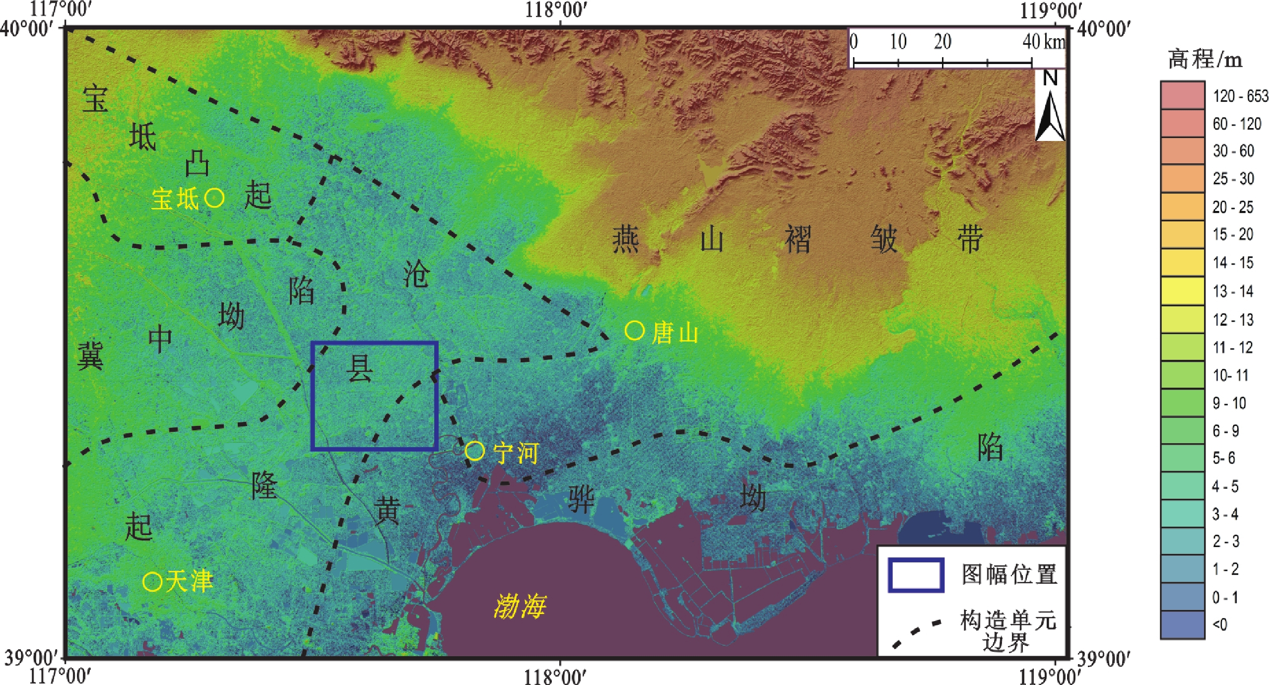
Figure 1.
Location map for geotectonics of the 1∶50 000 Huangzhuang map-sheet, Tianjin
-
Figure 2.
Construction process chart of the 1∶50 000 geologic map database of the Huangzhuang map-sheet, Tianjin