
| China Geological Survey Chinese Academy of Geological Sciences | Host |
| 科学出版社 | Publish |
| Citation: |
CHEN Yuanyuan, BU Ling, ZHUAN Shaopeng, YANG Rui, ZHAO Huaping, JI Hong, CHEN Chao, CHEN Hongqiang. 2020. Quaternary borehole database for 1∶50 000 Shaliu River Map-sheet of Hebei Province, China[J]. Geology in China, 47(S1): 125-134. doi: 10.12029/gc2020Z112

|
Quaternary borehole database for 1∶50 000 Shaliu River Map-sheet of Hebei Province, China
-
Abstract
The 1∶50 000 Shaliu River Map-sheet of Hebei Province is one of the key map-sheets for geological surveys of Beijing-Tianjin-Hebei plain Region, and the Late Cenozoic in the mapping area was mainly surveyed, with Quaternary borehole database reflecting the core achievement of the geological survey. By taking advantage of borehole construction and test data, as well as combining the collected borehole data, Quaternary borehole database was thus built, which mainly includes one basic data layers for borehole, five borehole catalog databases, five borehole design databases and five borehole histograms. Data source, data processing method, data attribute structure and data quality control are summarized in this paper, so as to present the practice of Quaternary borehole databases on the basis of Digital Geological Survey System (DGSS). The database provides a 3D geologic model of Tangshan urban area with basic data, serving coordinated development of Beijing-Tianjin-Hebei Region, which could also be referenced by borehole data processing and database construction in the geological survey of the other plain areas.
-
Keywords:
- Hebei province /
- 1∶50 000 /
- Shaliu river map-sheet /
- quaternary borehole /
- database /
- geological survey engineering
-

-
References
[1] 陈圆圆, 杨瑞, 赵华平, 卜令, 陈宏强. 2020. 河北省 1∶50 000 沙流河幅第四系钻孔数据库[DB/OL]. 地质科学数据出版系统. (2020-06-30). DOI: 10.35080/data.A.2020.P12. [2] 何静, 何晗晗, 郑桂森, 刘予, 周圆心, 肖景泽, 王纯君. 2019. 北京五环城区浅部沉积层的三维地质结构建模[J]. 中国地质, 46(2): 244−254. [3] 李超龄. 2011. 数字地质调查系统操作指南[M]. 北京: 地质出版社. [4] 唐丙寅. 2015. 城市第四系沉积相三维可视化精细建模研究[D]. 中国地质大学博士学位论文. [5] 中华人民共和国地质矿产部. 1993. 煤田地球物理测井规范: DZ/T 0080-1993. 北京: 中国标准出版社. [6] 中华人民共和国地质矿产部. 1997. 水文测井工作规范: DZ/T 0181-1997. 北京: 中国标准出版社. [7] 宗刚军. 2009. GIS数据质量控制的分析研究[J]. 西安科技大学学报, 29(5): 631−635. doi: 10.3969/j.issn.1672-9315.2009.05.026 [8] 朱良峰, 吴信才, 刘修国, 尚建嘎. 2004. 基于钻孔数据的三维地层模型的构建[J]. 地理与地理信息科学, 20(3): 26−29. doi: 10.3969/j.issn.1672-0504.2004.03.006 [9] 周毅, 郭高轩, 张磊, 蔡向民, 雷坤超. 2016. 北京后沙峪凹陷的第四纪地层划分与构造演化[J]. 中国地质, 43(3): 1067−1075. doi: 10.12029/gc20160328 [10] 左群超, 杨东来, 宋越, 马娟, 肖志坚. 2013. 中国矿产资源潜力评价成果数据质量控制及方法技术[J]. 中国地质, 40(4): 1314−1327. doi: 10.3969/j.issn.1000-3657.2013.04.028 [1] Chen Yuanyuan, Yang Rui, Zhao Huaping, Bu Ling, Chen Hongqiang. 2020. Quaternary borehole database for 1∶50 000 Shaliu River Map-sheet of Hebei Province, China[DB/OL]. Geoscientific Data & Discovery Publishing System. (2020-06-30). DOI: 10.35080/data.A.2020.P12. [2] He Jing, He Hanhan, Zheng Guisen, Liu Yu, Zhou Yuanxin, Xiao JingZe, Wang Chunjun. 2019. 3D geological modelling of superficial deposits in Beijing City[J]. Geology in China, 46(2): 244−254 (in Chinese with English abstract). [3] Li Chaoling. 2011. Instructions for Digital Geological Survey System [M]. Beijing: Geological Publishing House (in Chinese). [4] Ministry of Geology and Mineral Resources of the People's Republic of China. 1993. Specification for Geophysical Logging of Coal: DZ/T 0080–1993. Beijing: Standards Press of China (in Chinese). [5] Ministry of Geology and Mineral Resources of the People's Republic of China. 1997. Working Specification for Hydrogeological Logging: DZ/T 0181–1997. Beijing: Standards Press of China (in Chinese). [6] Tang Bingyin. 2015. Research on 3d visualization fine modeling of urban quaternary sedimentary facies [D]. Wuhan: China University of Geosciences (Wuhan) (in Chinese with English abstract). [7] Zhou Yi, Guo Gaoxuan, Zhang Lei, Cai Xiangmin, Lei Kunchao. 2016. The division of Quaternary strata and tectonic evolution in Houshayu Sag of Beijing[J]. Geology in China, 43(3): 1067−1075 (in Chinese with English abstract). [8] Zhu Liangfeng, Wu Xincai, Liu Xiuguo, Shang Jianga. 2004. Reconstruction of 3D strata model based on borehole data[J]. Geography and Geo-information Science, 20(3): 26−30 (in Chinese with English abstract). [9] Zong Gangjun. 2009. Quality control of fundamental geographic information data[J]. Journal of Xi′an University of Science and Technology, 29(5): 631−635 (in Chinese with English abstract). [10] Zuo Qunchao, Yang Donglai, Song Yue, Ma Juan, Xiao Zhijian. 2013. The data quality control and technique of the mineral resources potential evaluation in China[J]. Geology in China, 40(4): 1314−1327 (in Chinese with English abstract). -
Access History

Figures(4)
Tables(12)

Export File
Citation
CHEN Yuanyuan, BU Ling, ZHUAN Shaopeng, YANG Rui, ZHAO Huaping, JI Hong, CHEN Chao, CHEN Hongqiang. 2020. Quaternary borehole database for 1∶50 000 Shaliu River Map-sheet of Hebei Province, China[J]. Geology in China, 47(S1): 125-134. doi: 10.12029/gc2020Z112
Format
Content
 DownLoad:

- Figure 1.
- Figure 2.
-
Figure 1.
Borehole location map of the 1∶50 000 Shaliu river map-sheet of Hebei province
-
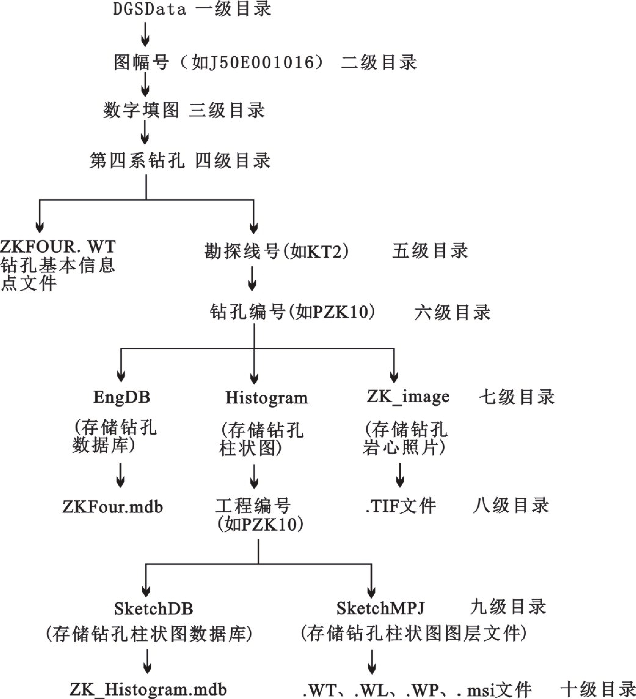
Figure 2.
Database directory structure diagram of quaternary borehole