

| Citation: |
ZHOU Dingyi, ZUO Xiaoqing, ZHAO Zhifang, XI Wenfei, GE Chu. 2023. Prediction of urban land subsidence by SBAS-InSAR and improved BP neural network. Geological Bulletin of China, 42(10): 1774-1783. doi: 10.12097/j.issn.1671-2552.2023.10.013

|
Prediction of urban land subsidence by SBAS-InSAR and improved BP neural network
-
Abstract
In response to the issues of excessive reliance on subsidence data and a lack of model diversity in existing urban ground subsidence prediction methods, this study focuses on the main urban area of Kunming City, Yunnan Province. A novel approach for predicting urban ground settlement is proposed, incorporating a multi-temporal sequence and multifactor perspective into the improved BP neural network. Firstly, SBAS-InSAR technology is utilized to acquire monitoring values of ground settlement in the main urban area. Subsequently, gray correlation analysis and factor analysis in SPSSAU software are employed to identify the influencing factors of ground settlement in this specific area. Based on the obtained settlement monitoring values and the identified influencing factors, GA-BP and PSO-BP prediction models are constructed from a multifactor multi-temporal sequence viewpoint. The optimal prediction model is determined and its performance is evaluated through comprehensive validation. Experimental results demonstrate that SBAS-InSAR effectively monitors urban ground settlement, while the GA-BP algorithm outperforms the PSO-BP algorithm in terms of prediction accuracy and overall performance. This method allows for long-term and large-scale predictions of urban ground settlement, as well as forecasting the settlement trends of specific points over multiple periods. Consequently, it serves as an effective tool for urban ground settlement prediction, providing governmental departments with an efficient and fast decision-making approach.
-
Keywords:
- SBAS-InSAR /
- subsidence monitoring /
- influence factor /
- BP algorithm
-

-
References
[1] Du W, Ji W, Xu L, et al. Deformation time series and Driving-Force Analysis of Glaciers in the Eastern Tienshan Mountains Using the SBAS InSAR Method[J]. International Journal of Environmental Research and Public Health, 2020, 17(8): 2836. doi: 10.3390/ijerph17082836 [2] Goldstein R. Atmospheric limitations to repeat-track radar interferometry[J]. Geophysical Research Letters, 1995, 22(18): 2517-2520. doi: 10.1029/95GL02475 [3] Guo L, Gong H, Ke Y, et al. Mechanism of land subsidence mutation in Beijing plain under the background of urban expansion[J]. Remote Sensing, 2021, 13(16): 3086. doi: 10.3390/rs13163086 [4] Li J C. Settlement Prediction of Buildings Based on BP Neural Network[J]. Applied Mechanics and Materials, 2014, 602/605: 3232-3234. doi: 10.4028/www.scientific.net/AMM.602-605.3232 [5] Pradhan B, Abokharima M H, Jebur M N, et al. Land subsidence susceptibility mapping at Kinta Valley(Malaysia) using the evidential belief function model in GIS[J]. Natural Hazards, 2014, 73(2): 1019-1042. doi: 10.1007/s11069-014-1128-1 [6] Wang C, Zhang H, Shan X, et al. Applying SAR Interferometry for ground deformation detection in China[J]. Photogrammetric Engineering & Remote Sensing, 2004, 70(10): 1157-1165. [7] Zhang Y, Liu Y L, Jin M, et al. Monitoring land subsidence in Wuhan city(China) using the SBAS-InSAR Method with Radarsat-2 Imagery Data[J]. Sensors, 2019, 19(3): 743. doi: 10.3390/s19030743 [8] Zhang Z, Lou Y, Zhang W, et al. On the assessment GPS-Based WRFDA for InSAR Atmospheric Correction: A case study in Pearl River Delta region of China[J]. Remote Sensing, 2021, 13(16): 3280. doi: 10.3390/rs13163280 [9] Zhou D, Zuo X, Zhao Z. Constructing a large-scale urban land subsidence prediction method based on neural network algorithm from the perspective of multiple factors[J]. Remote Sensing, 2022, 14(8): 1803. doi: 10.3390/rs14081803 [10] 邓传军, 欧阳斌, 陈艳红. 一种基于PSO-BP神经网络的建筑物沉降预测模型[J]. 测绘科学, 2018, 43(6): 27-31, 38. [11] 杜东, 刘宏伟, 周佳慧, 等. 北京市通州区地面沉降特征与影响因素研究[J]. 地质学报, 2022, 96(2): 712-725. [12] 顾波, 刘炫. 试析灰色理论模型在地面沉降预测中的应用[C]//浙江省测绘与地理信息学会. 2016年度浙江省测绘与地理信息学会优秀论文集. 浙江省测绘与地理信息学会, 2016: 5. [13] 郭海朋, 李文鹏, 王丽亚, 等. 华北平原地下水位驱动下的地面沉降现状与研究展望[J]. 水文地质工程地质, 2021, 48(3): 162-171. [14] 贾林刚. 基于BP神经网络的地表沉降预测模型[J]. 煤矿开采, 2008, (1): 15-17. [15] 何永红, 靳鹏伟, 舒敏. 基于多尺度相关性分析的InSAR对流层延迟误差改正算法[J]. 地球信息科学学报, 2020, 22(9): 1878-1886. [16] 李涛, 潘云, 娄华君, 等. 人工神经网络在天津市区地面沉降预测中的应用[J]. 地质通报, 2005, 24(7): 677-681. [17] 李红霞, 赵新华, 迟海燕, 等. 基于改进BP神经网络模型的地面沉降预测及分析[J]. 天津大学学报, 2009, 42(1): 60-64. [18] 麻源源. 基于星载InSAR的地面沉降及山体滑坡监测[D]. 昆明理工大学硕士学位论文, 2019. [19] 孟庆凯, 汪宝存, 苗放. 基于短基线集方法(SBAS-INSAR) 技术的山区城市地面沉降监测研究——以攀枝花为例[J]. 科学技术与工程, 2016, 16(13): 12-17. [20] 王霞迎, 张菊清, 张勤, 等. 升降轨InSAR与GPS数据集成反演西安形变场[J]. 测绘学报, 2016, 45(7): 810-817. [21] 王聪, 王彦兵, 周朝栋. 通州区城市扩张对地面沉降的影响[J]. 首都师范大学学报(自然科学版), 2018, 39(4): 68-74. [22] 王博. 基于升降轨InSAR数据的地表二维形变场获取方法研究[D]. 河南大学硕士学位论文, 2020. [23] 熊鹏, 左小清, 李勇发, 等. 双极化Sentinel-1数据在昆明市沉降监测中的应用[J]. 地球物理学进展, 2020, 35(4): 1317-1322. [24] 张良均, 曹晶, 蒋世忠. 神经网络实用教程[M]. 北京: 机械工业出版社, 2008. [25] 张金芝, 黄海军, 毕海波, 等. SBAS时序分析技术监测现代黄河三角洲地面沉降[J]. 武汉大学学报(信息科学版), 2016, 41(2): 242-248. [26] 张玲霞, 赵晓光, 曹庆东. GM-AR模型在城市地面沉降预测中的应用[C]//《建筑科技与管理》组委会. 2017年8月建筑科技与管理学术交流会论文集. 《建筑科技与管理》组委会: 北京恒盛博雅国际文化交流中心, 2017: 2. [27] 张勤, 黄观文, 杨成生. 地质灾害监测预警中的精密空间对地观测技术[J]. 测绘学报, 2017, 46(10): 1300-1307. [28] 种亚辉, 董少春, 胡欢. 基于时序InSAR技术的常州市地面沉降监测与分析[J]. 高校地质学报, 2019, 25(1): 131-143. [29] 周定义. 基于星载InSAR和神经网络的城市地面沉降监测及预测[D]. 昆明理工大学硕士学位论文, 2023. [30] 周艳萍. 基于BP神经网络的太原市地面沉降预测及分析[J]. 地质科技情报, 2011, 30(5): 115-118. -
Access History
Figures(10)
Tables(3)

Export File
Citation
ZHOU Dingyi, ZUO Xiaoqing, ZHAO Zhifang, XI Wenfei, GE Chu. 2023. Prediction of urban land subsidence by SBAS-InSAR and improved BP neural network. Geological Bulletin of China, 42(10): 1774-1783. doi: 10.12097/j.issn.1671-2552.2023.10.013
Format
Content
 DownLoad:


-
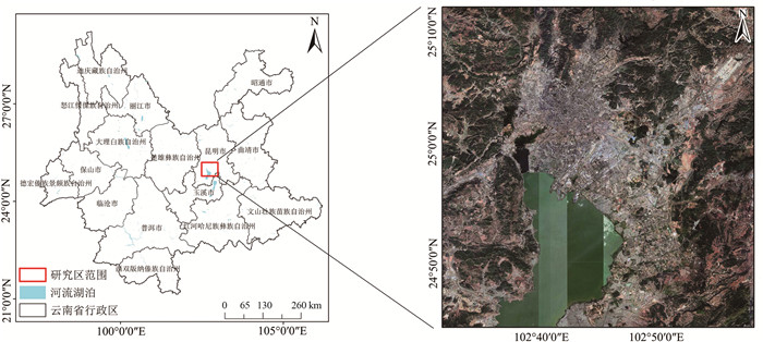
Figure 1.
Location of study area
-
Figure 2.
Partial interference images generated in the study area
-
Figure 3.
Annual sedimentation rate in LOS direction
-
Figure 4.
Diagram of vertical annual settlement rate
-
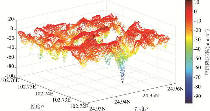
Figure 5.
3D discrete settlement rate diagram
-
Figure 6.
Quantitative treatment diagram of impact factors
-
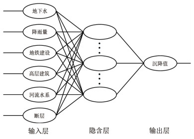
Figure 7.
GA/PSO-BP neural network model
-
Figure 8.
Comparison of prediction results under different optimization algorithms
-
Figure 9.
The optimal number of iterations under different optimization algorithms
-
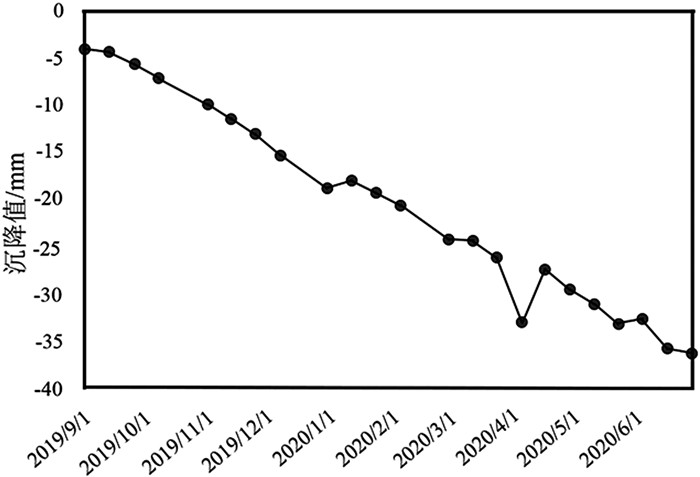
Figure 10.
Sequence diagram of settlement point S1