
| Citation: |
LIANG Xinyue, ZENG Lu, GE Yonggang, DU Yuchen, CAO Xiaojuan. The distribution characteristics of debris flow along the Luhuo-Daofu section of Xianshuihe fault, west Sichuan Province[J]. Geological Bulletin of China, 2021, 40(12): 2061-2070.

|
The distribution characteristics of debris flow along the Luhuo-Daofu section of Xianshuihe fault, west Sichuan Province
-
Abstract
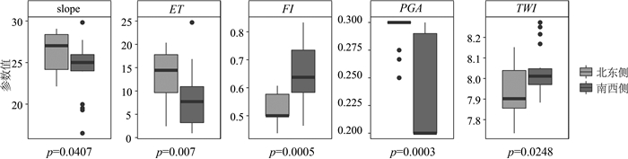
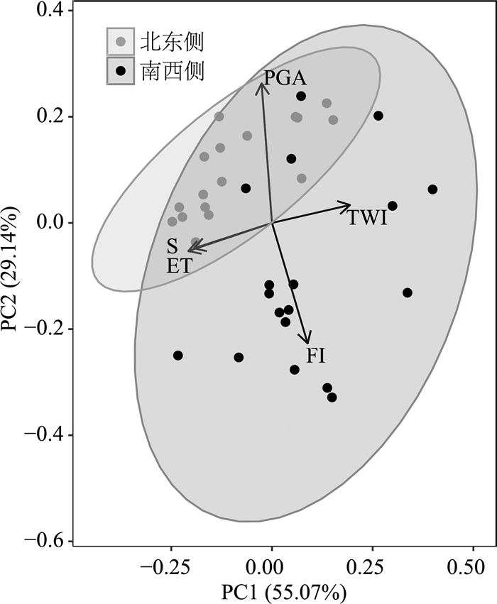
The Debris flow in Luhuo-Daofu section is linearly distributed along the Xianshuihe fault.It is mainly medium and high frequency, transitional and diluted debris flow.In the fault, the rock mass is broken, the secondary structure is developed with strong activity, so that the main riverbed is stepped, which provides potential energy transformation, material supply and hydraulic transport conditions for the development of debris flow disaster.Debris flow gullies (Ksn about 140 m0.9) are distributed at the high river steepness indices of the trunk river (Ksn about 66 m0.9).Moreover, debris flow gullies on the middle and lower reaches of the river and the trunk river in which they enter are more consistent in the trend of the river steepness indices.Wilcoxon test shows that the slope (26.5°), excess height (13.3 m) and peak ground acceleration of debris flow gullies on the northeast of the Xianshuihe fault are significantly higher than those on the southwest.Compared with debris flow gullies on the northeast of the Xianshuihe fault, the lithology of debris flow gullies on the southwest side are softer, and the topographic wetness index are larger.The principal component analysis indicates that the geology and geomorphology of debris flow gullies on the northeast side are relatively similar, mainly in steep terrain, and the geomorphology of debris flow gullies on the southwest side are more complex due to the influence of lithology and hydrological transportation capacity.The systematic understanding of debris flow gullies along the Luhuo-Daofu section can provide a reference for the prevention and control of debris flow disasters on the G317 Highway.
-
Keywords:
- Xianshuihe fault /
- tectonic movement /
- geology and geomorphology /
- debris flow
-

-
References
[1] 张永双, 郭长宝, 姚鑫, 等. 青藏高原东缘活动断裂地质灾害效应研究[J]. 地球学报, 2016, 37(3): 277-286. [2] 谢吉尊, 冯文凯, 杨少帅, 等. 则木河断裂带活动特征和地质灾害对地貌演化的影响——以鹅掌河流域为例[J]. 工程地质学报, 2017, 25(3): 772-783. [3] 郭长宝, 杜宇本, 张永双, 等. 川西鲜水河断裂带地质灾害发育特征与典型滑坡形成机理[J]. 地质通报, 2015, 34(1): 121-134. doi: 10.3969/j.issn.1671-2552.2015.01.010 [4] 马俊, 徐连三, 李云, 等. 青峰主干断裂带(房县段)地质灾害发育规律研究[J]. 资源环境与工程, 2020, 34(S1): 39-45. [5] 闫茂华, 魏云杰, 李亚民, 等. 云南德钦日因卡滑坡孕灾背景及形成机理[J]. 地质通报, 2020, 39(12): 1971-1980. [6] 余斌, 马煜, 张健楠, 等. 汶川地震后四川省都江堰市龙池镇群发泥石流灾害[J]. 山地学报, 2011, 29(6): 738-746. doi: 10.3969/j.issn.1008-2786.2011.06.014 [7] Huang X, Tang C. Formation and activation of catastrophic debris flows in Baishui River basin, Sichuan Province, China[J]. Landslides, 2014, 11(6): 955-967. doi: 10.1007/s10346-014-0465-1 [8] 胡凯衡, 葛永刚, 崔鹏, 等. 对甘肃舟曲特大泥石流灾害的初步认识[J]. 山地学报, 2010, 28(5): 628-634. doi: 10.3969/j.issn.1008-2786.2010.05.017 [9] 万佳威, 褚宏亮, 李滨, 等. 西藏嘉黎断裂带沿线高位链式地质灾害发育特征分析[J]. 中国地质灾害与防治学报, 2021, 32(3): 51-60. [10] 丁明涛, 韦方强. 云南蒋家沟泥石流成因及其防治措施探析[J]. 水土保持研究, 2008, (1): 20-22. [11] 王哲威, 徐正宣, 冯涛, 等. 川藏铁路鲜水河构造带地质选线研究[J]. 工程地质学报, 2021, 29(2): 466-477. [12] Shen Z K, Lü J N, Wang M, et al. Contemporary crustal deformation around the southeast borderland of the Tibetan Plateau[J]. Journal of Geophysical Research, 2005, 110: B11409. [13] 唐文清, 陈智梁, 刘宇平, 等. 青藏高原东缘鲜水河断裂与龙门山断裂交会区现今的构造活动[J]. 地质通报, 2005, 24(12): 1169-1172. doi: 10.3969/j.issn.1671-2552.2005.12.013 [14] 姚鑫, 张永双, 李凌婧, 等. 青藏高原鲜水河活动断裂带蠕变斜坡地质灾害InSAR识别研究[J]. 地质学报, 2017, 91(8): 1694-1705. doi: 10.3969/j.issn.0001-5717.2017.08.003 [15] 梁明剑, 鲜水河断裂晚第四纪活动习性[D]. 中国地震局地质研究所博士学位论文, 2019. [16] 白永健, 铁永波, 倪化勇, 等. 鲜水河流域地质灾害时空分布规律及孕灾环境研究[J]. 灾害学, 2014, 29(4): 69-75. doi: 10.3969/j.issn.1000-811X.2014.04.014 [17] Alaska Satellite Facility SAR Data Center(ASF). ALOS PALSAR[DB]. (2008-01-29). [2021-03-10]. https://search.asf.alaska.edu/#/?tdsourcetag=s_pctim_aiom.sg&flightDirs=.2008. [18] 全国地质资料馆. 中华人民共和国1: 20万地质图(丹巴幅(H-47-XII); 新龙幅(H-47-XI); 炉霍幅(H-47-V)[CM]. [2013-03-11]. http://www.ngac.org.cn/DataSpecial/geomap.html.2013. [19] 张威, 唐倩玉, 刘亮, 等. 基于面积-高程积分的他念他翁山玉曲流域地貌学分析[J]. 地理科学, 2020, 40(8): 1394-1402. [20] 何福红, 高丙舰, 王焕芝, 等. 基于GIS的侵蚀冲沟与地貌因子的关系[J]. 地理研究, 2013, 32(10): 1856-1864. [21] 张彩霞, 杨勤科, 李锐. 基于DEM的地形湿度指数及其应用研究进展[J]. 地理科学进展, 2005, (6): 116-123. doi: 10.3969/j.issn.1007-6301.2005.06.014 [22] 王丽娟, 马超, 苗绿. 坡面泥石流形态和堆积特征研究[J]. 自然灾害学报, 2020, 29(6): 98-106. [23] Blöthe J H, Korup O, Schwanghart W. Large landslides lie low: Excess topography in the Himalaya-Karakoram ranges[J]. Geology, 2015, 43(6): 523-526. doi: 10.1130/G36527.1 [24] 赵岩. 基于机器学习的白龙江流域潜在低频泥石流沟识别[D]. 兰州大学博士学位论文, 2020. [25] 王秀英, 聂高众, 王登伟. 汶川地震诱发滑坡与地震动峰值加速度对应关系研究[J]. 岩石力学与工程学报, 2010, 29(1): 82-89. [26] 乔荣荣, 季树新, 白雪莲, 等. 流域沟壑数量特征与侵蚀量关系[J]. 中国水土保持科学, 2020, 18(6): 9-14. [27] Howard A D, Kerby G. Channel changes in badlands[J]. GSA Bulletin, 1983, 94(6): 739-752. doi: 10.1130/0016-7606(1983)94<739:CCIB>2.0.CO;2 [28] Chen Y W, Shyu J B H, Chang C P. Neotectonic characteristics along the eastern flank of the Central Range in the active Taiwan orogen inferred from fluvial channel morphology[J]. Tectonics, 2015, 34(10): 2249-2270. doi: 10.1002/2014TC003795 [29] Flint J J. Stream gradient as a function of order, magnitude, and discharge[J]. Water Resources Research, 1974, 10(5): 969-973. doi: 10.1029/WR010i005p00969 [30] Tucker G E, Whipple K X. Topographic outcomes predicted by stream erosion models: Sensitivity analysis and intermodel comparison[J]. Journal of Geophysical Research: Solid Earth, 2002, 107(B9): ETG 1-1-ETG 1-16. doi: 10.1029/2001JB000162 [31] Munack H, Korup O, Resentini A, et al. Postglacial denudation of western Tibetan Plateau margin outpaced by long-term exhumation[J]. GSA Bulletin, 2014, 126(11/12): 1580-1594. [32] Kirby E, Whipple K X. Expression of active tectonics in erosional landscapes[J]. Journal of Structural Geology, 2012, 44: 54-75. doi: 10.1016/j.jsg.2012.07.009 [33] Church M, Jakob M. What Is a Debris Flood?[J]. Water Resources Research, 2020, 56(8): e2020WR027144. [34] Jackson L, Kostaschuk R, MacDonald G. Identification of debris flow hazard on alluvial fans in the Canadian Rocky Mountains[C]//Debris flow/avalanches: Process, Recognition, Mitigation, 1984: 115-124. [35] 胡凯衡, 魏丽, 刘双, 等. 横断山区泥石流空间格局和激发雨量分异性研究[J]. 地理学报, 2019, 74(11): 2303-2313. doi: 10.11821/dlxb201911008 [36] 高翔, 邓起东, 陈汉林, 等. 新疆富蕴断裂带枢纽运动的有限元数值模拟研究[J]. 大地构造与成矿学, 2015, 39(5): 769-779. [37] 刘晓霞, 邵志刚. 丽江-小金河断裂带现今断层运动特征[J]. 地球物理学报, 2020, 63(3): 1117-1126. [38] Duan B, Oglesby D D. Multicycle dynamics of nonplanar strike-slip faults[J]. Journal of Geophysical Research: Solid Earth, 2005, 110: B03304. [39] 李天袑, 杜其方. 鲜水河活动断裂带及强震危险性评估[M]. 成都: 成都地图出版社, 1997. [40] 闻学泽. 四川西部鲜水河-安宁河-则木河断裂带的地震破裂分段特征[J]. 地震地质, 2000, (3): 239-249. doi: 10.3969/j.issn.0253-4967.2000.03.005 [41] 葛培基. 鲜水河断裂带在虾拉沱附近的现今活动特征[J]. 地震地质, 1989, (3): 55-63. [42] 金德生, 张欧阳, 陈浩, 等. 侵蚀基准面下降对水系发育与产沙影响的实验研究[J]. 地理研究, 2003, (5): 560-570. doi: 10.3321/j.issn:1000-0585.2003.05.004 [43] 李明辉, 王东辉, 高延超, 等. 鲜水河断裂带炉霍7.9级地震地质灾害研究[J]. 灾害学, 2014, 29(1): 37-41. [44] 伍纯昊, 崔鹏, 李渝生, 等. 青藏高原东缘活动断裂带地壳岩体构造损伤特征与模式讨论[J]. 工程地质学报, 2021, 29(2): 289-306. [45] 谢吉尊, 冯文凯, 胡云鹏, 等. 天然和饱水状态下泥岩力学性质及损伤变形能量特征分析[J]. 水文地质工程地质, 2016, 43(3): 66-72, 78. [46] 冯文凯, 黄润秋, 许强. 斜坡震裂变形发育分布规律及危险性分析[J]. 成都理工大学学报(自然科学版), 2010, 37(6): 679-684. doi: 10.3969/j.issn.1671-9727.2010.06.014 [47] 罗永红, 王运生. 汶川地震诱发山地斜坡震动的地形放大效应[J]. 山地学报, 2013, 31(2): 200-210. doi: 10.3969/j.issn.1008-2786.2013.02.009 [48] 张永双, 成余粮, 姚鑫, 等. 四川汶川地震-滑坡-泥石流灾害链形成演化过程[J]. 地质通报, 2013, 32(12): 1900-1910. -
Access History

Figures(7)
Tables(2)

Export File
Citation
LIANG Xinyue, ZENG Lu, GE Yonggang, DU Yuchen, CAO Xiaojuan. The distribution characteristics of debris flow along the Luhuo-Daofu section of Xianshuihe fault, west Sichuan Province[J]. Geological Bulletin of China, 2021, 40(12): 2061-2070.
Format
Content
 DownLoad:

-
Figure 1.
Geographic location of the study area
-
Figure 2.
Topography and the distribution of the Xianshuihe fault of the study area (a), UAV image of debris flow gullies(b) and photos of debris flow gullies(c, d)
-
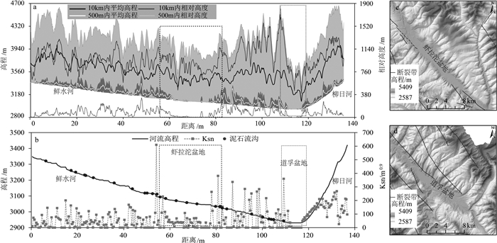
Figure 3.
Maximum / minimum elevation on both sides along the Luhuo-Daofu section of Xianshui River(a) and river profile and river steepness indices along the Luhuo-Daofu section of Xianshui River(b)
-
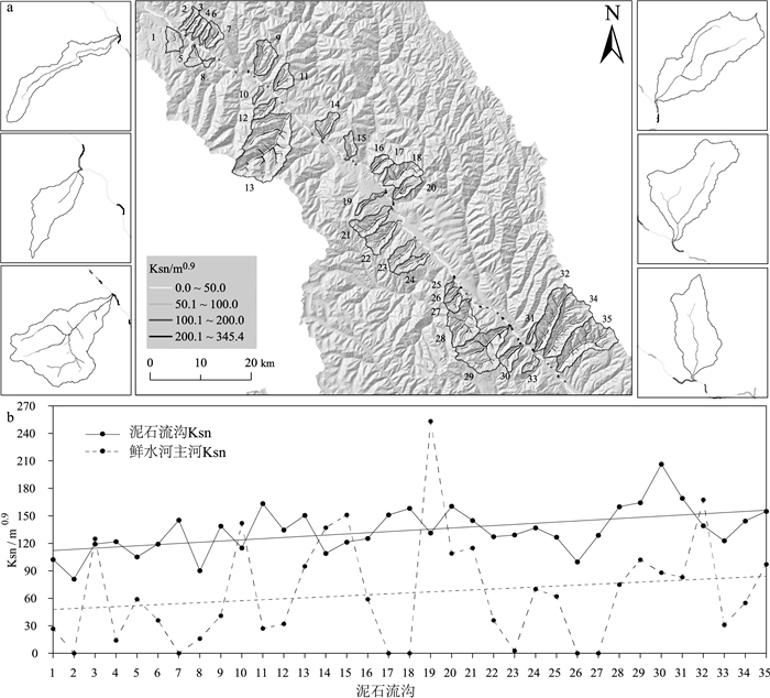
Figure 4.
Spatial distribution of river steepness indices of typical debris flow gully and the Xianshui River(a) and relationship of river steepness indices of between debris flow gully and its entering estuary (b)
-
Figure 5.
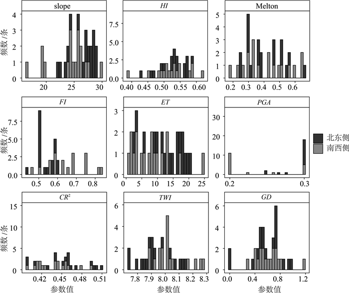
Histogram of geological and geomorphological parameters of debris flow gullies in the study area
-
Figure 6.
Wilcoxon test of geological and geomorphological parameters of debris flow gullies on the both sides of the Xianshui River
-
Figure 7.
Principal component analysis of geological and geomorphological parameters of debris flow gullies on the both sides of the Xianshui River