
| Institute of Geomechanics, Chinese Academy of Geological Sciences | Host |
| Citation: |
SHI Xiao-ya, WANG Zhan-chang, WU Jin-cheng. DEMONSTRATION APPLICATION OF BEIDOU SATELLITE TECHNOLOGY IN DETAILED GEOLOGICAL DISASTER INVESTIGATION IN YUSHU, QINGHAI PROVINCE[J]. Journal of Geomechanics, 2012, 18(3): 277-281, 287.

|
DEMONSTRATION APPLICATION OF BEIDOU SATELLITE TECHNOLOGY IN DETAILED GEOLOGICAL DISASTER INVESTIGATION IN YUSHU, QINGHAI PROVINCE
-
Abstract
Based on the positioning and communication of Beidou Navigation Satelliate System, which combines IP satellite technology, network and grid technology, the modern field geological work management and service mode are established to realize the information interconnection and interflow between the investigator in-field, investigator in-residence, field station, regional center of investigator and China Geological Survey. The department of project management may inspect the work of investigator in the field, get the work progress in the field, and provide remote service of emergency disposal by internet any time. The demonstrated application revealed very well to the modern field geological work management and service mode in the project of detailed geological disaster survey in Yushu, Qinghai Province.
-

-
References
[1] 朱永辉, 白征东, 过静珺, 等.基于北斗一号的地质灾害自动监测系统[J].测绘通报, 2010, (2):5~7. ZHU Yong-hui, BAI Zheng-dong, GUO Jing-jun, et al. A new wireless system for geological disasters monitoring based on Beidou Ⅰ[J]. Bulletin of Surveying and Mapping, 2010, (2):5~7. -
Access History
Figures(3)

Export File
Citation
SHI Xiao-ya, WANG Zhan-chang, WU Jin-cheng. DEMONSTRATION APPLICATION OF BEIDOU SATELLITE TECHNOLOGY IN DETAILED GEOLOGICAL DISASTER INVESTIGATION IN YUSHU, QINGHAI PROVINCE[J]. Journal of Geomechanics, 2012, 18(3): 277-281, 287.
Format
Content
 DownLoad:

-
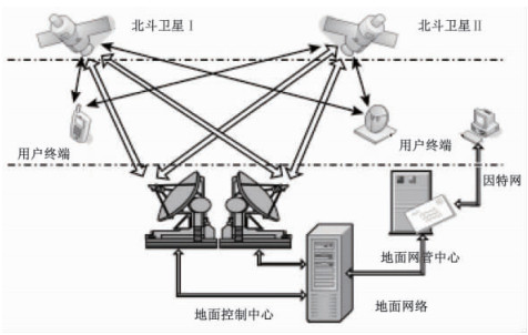
Figure 1.
Diagram of position and communication system of Beidou Satellite
-
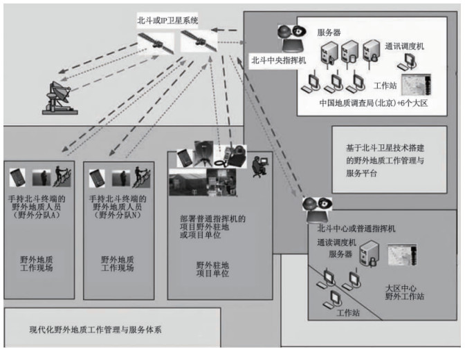
Figure 2.
Diagram of management and service mode of field geological survey based on Beidou satellite technology
-
Figure 3.
Diagram of network organization