
| Institute of Geomechanics, Chinese Academy of Geological Sciences | Host |
| Citation: |
XIAO Zheng-hao, WANG Da-ming, WEN Jing, FANG Hong-bin, HU Yu-xin, XU Ning. OVERVIEW OF THE GROUND APPLICATION SYSTEM OF SATELLITE-AVIATION-GROUND REMOTE SENSING DATA AT HOME AND ABROAD[J]. Journal of Geomechanics, 2015, 21(2): 117-128.

|
OVERVIEW OF THE GROUND APPLICATION SYSTEM OF SATELLITE-AVIATION-GROUND REMOTE SENSING DATA AT HOME AND ABROAD
-
Abstract
Ground remote sensing system is mainly used for receiving, processing, managing and distributing, for developing a further satellite-aviation-ground system which can be applied to geological exploration and processing mass hyperspectral remote sensing data, this article summarized and analyzed characteristics, components and development direction of ground remote sensing system at home and abroad, such as satellite system, aviation system and ground core system. This overview offered technical basic and theoretical support for developing remote sensing system for geological exploration.
-

-
References
[1] Galeazzi C, Carpentiero R, V. De Cosmo. The Prisma System and Pan/Hyp Instrument. [2] Storch T, Amaia de Miguel, Palubinskas G, et al. Processing chain for the future hyperspectral mission EnMAP[C]//Conference Papers of the 6th EARSeL SIG-IS Workshop Imaging Spectroscopy. Israel: Tel Aviv, 2009. [3] Dario Cabib, Moshe Lavi, Amir Gil. Long wave infrared (8 to 12 microns) hyperspectral imager based on an uncooled thermal camera and the traditional CI block interferometer[C]//Conference Papers of the 7th EARSeL SIG-IS Workshop Imaging Spectroscopy. Edinburgh: SPIE, 2011. [4] Laruent Rousset-Rouviere. SYSIPHE, airborne hyperspectral imager system[C]//Conference Papers of the 7th EARSeL SIG-IS Workshop Imaging Spectroscopy. Edinburgh: SPIE, 2011. [5] Glavich T, Green R O, Hook S J, et al. Decadal survey symposium HyspIRI decadal survey Mission development status. February 11-12, 2009. NASA Headquarters. [6] Tappert M, Rivard B, Giles D, et al. Automated drill core logging using visible and near-infrared reflectance spectroscopy: A case study from the Olympic Dam IOCG Deposit, South Australia[J]. Economic Geology, 2011, 106: 289~296. doi: 10.2113/econgeo.106.2.289 [7] Roache T, et al. Microscopic remote sensing as a scale-integrated tool in mineral exploration. GRSG-OGEO Workshop-7-9th December 2011; Frascati, Italy. -
Access History

Figures(9)
Tables(2)

Export File
Citation
XIAO Zheng-hao, WANG Da-ming, WEN Jing, FANG Hong-bin, HU Yu-xin, XU Ning. OVERVIEW OF THE GROUND APPLICATION SYSTEM OF SATELLITE-AVIATION-GROUND REMOTE SENSING DATA AT HOME AND ABROAD[J]. Journal of Geomechanics, 2015, 21(2): 117-128.
Format
Content
 DownLoad:


-
Figure 1.
The figure of MightySatⅡ.1/FTHSI system structure
-
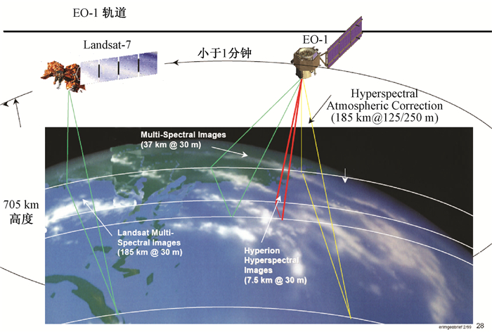
Figure 2.
The flight track and cover area of EO-1
-
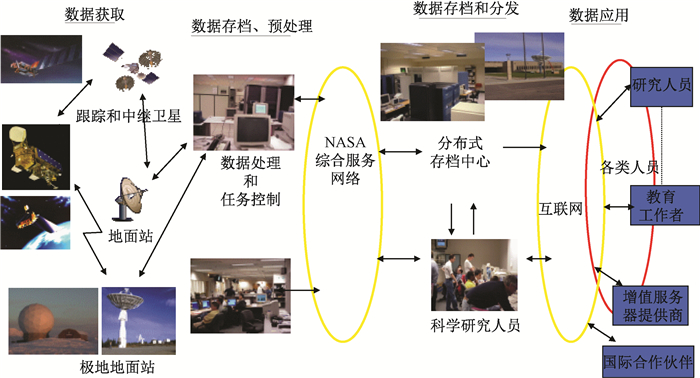
Figure 3.
The ground application system structure of EO-1
-
Figure 4.
The structure of EnMAP
-
Figure 5.
The ground processing system of EnMAP
-
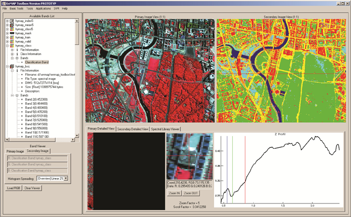
Figure 6.
The application software of EnMap hyperspectral data based on IDL
-
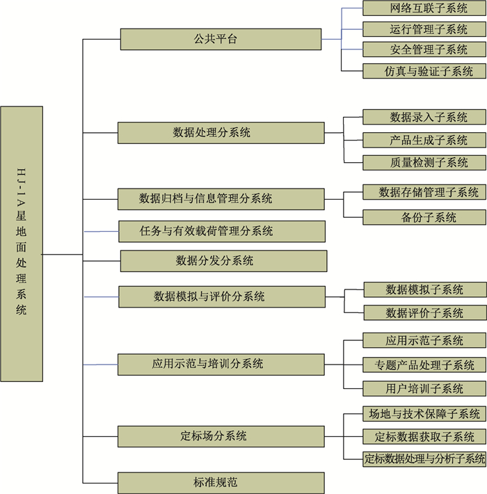
Figure 7.
The ground processing system structure of HJ-1A
-
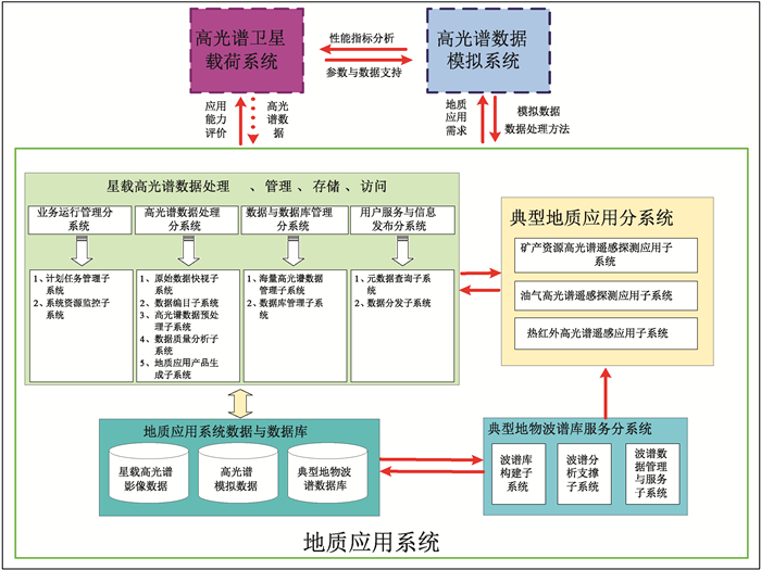
Figure 8.
The overall framework for ground application system of land resource hyperspectral satellite
-
Figure 9.
The layered construction for ground application system of land resource hyperspectral satellite