
| Institute of Geomechanics, Chinese Academy of Geological Sciences | Host |
| Citation: |
LIANG Shu-neng, GAN Fu-ping, ZHANG Zhen-hua, WEI Hong-yan, XIAO Chen-chao, WEI Dan-dan. INTRODUCTION OF THE REMOTE SENSING TEST FIELD SITE CONSTRUCTION PROGRESS AT HOME AND ABROAD[J]. Journal of Geomechanics, 2015, 21(2): 129-141.

|
INTRODUCTION OF THE REMOTE SENSING TEST FIELD SITE CONSTRUCTION PROGRESS AT HOME AND ABROAD
-
Abstract
Remote sensing test site is an important foundation for the quantitative application of remote sensing which can be used to carry out basic research, technology test, payload index demonstration and evaluation, remote sensing image quality evaluation and so on. In the research field of Geology and Mineral Resources, remote sensing is one of the most important supporting technologies for geological survey, mineral resource evaluation, surveying and evaluating geological disaster and geological environments survey. Under the support of the project "Research of integrated test field for resources and energy survey using space-borne remote sensing techniques" which is a grant from China Geological Survey, we investigated the construction of the remote sensing testing site, compared and analyzed the establishment purpose, the observation content and the application situation of the main remote sensing testing ground at home and abroad had provided an important reference to the construction of Hami remote sensing test site. This research is of great significance to promote the quantitative application of remote sensing techniques in the field of geological mineral resources survey and environment evaluation, and it overcome the blindness of remote sensing data application and promotion.
-

-
References
[1] 荀毓龙.遥感基础试验与应用[M].北京:中国科学技术出版社, 1991. XUN Yu-long. Basic test and application of remote sensing[M]. Beijing: China Science and Technology Press, 1991. [2] 李志忠, 杨日红, 党福星, 等.高光谱遥感卫星技术及其地质应用[J].地质通报, 2009, 28(2/3):270~277. LI Zhi-zhong, YANG Ri-hong, DANG Fu-xing, et al. The hyperspectral remote sensing technology and its application[J]. Geological Bulletin of China, 2009, 28(2/3): 270~277. [3] Clark R N, Swayze G A, Livo K E, et al. Imaging spectroscopy: Earth and planetary remote sensing with the USGS Tetracorder and expert systems[J]. Journal of Geophysical Research: Planets, 2003, 108(E12): 5~44. [4] Rowan L C, Hook S J, Abrams M J, et al. Mapping hydrothermally altered rocks at Cuprite, Nevada, using the advanced spaceborne thermal emission and reflection radiometer(Aster), a new satellite-imaging system[J]. Economic Geology, 2003, 98(5): 1019~1027. doi: 10.2113/gsecongeo.98.5.1019 -
Access History
Figures(6)
Tables(3)

Export File
Citation
LIANG Shu-neng, GAN Fu-ping, ZHANG Zhen-hua, WEI Hong-yan, XIAO Chen-chao, WEI Dan-dan. INTRODUCTION OF THE REMOTE SENSING TEST FIELD SITE CONSTRUCTION PROGRESS AT HOME AND ABROAD[J]. Journal of Geomechanics, 2015, 21(2): 129-141.
Format
Content
 DownLoad:

-
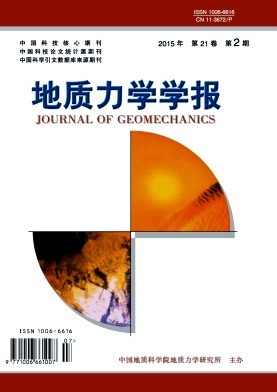
Figure 1.
Geological sketch map of Cuprite mining area
-
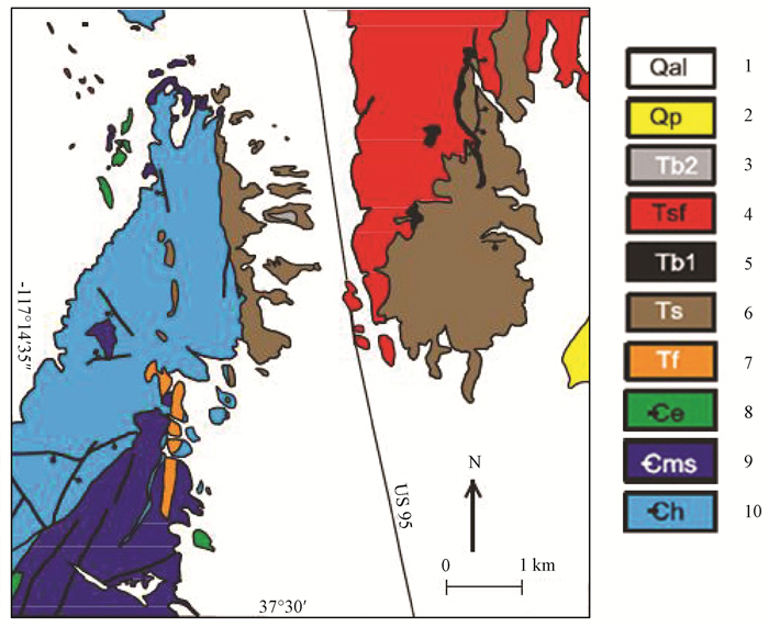
Figure 2.
Three alteration rock units in Cuprite mine area
-
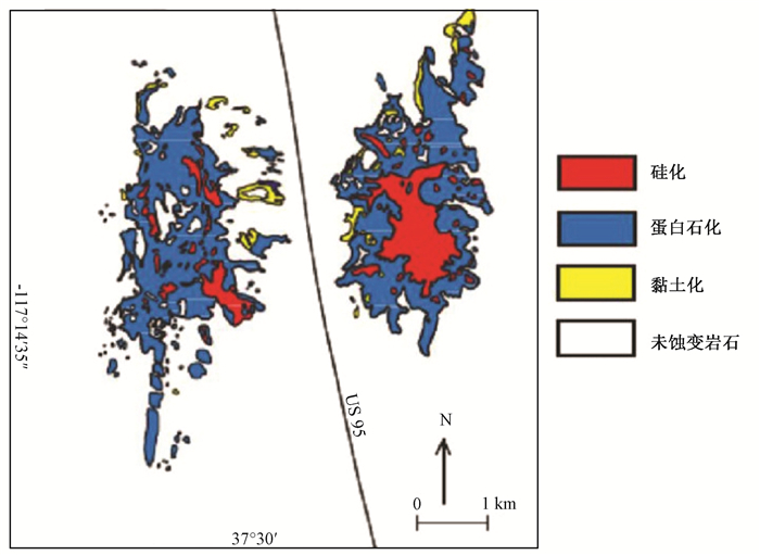
Figure 3.
Mineral distribution map in Cuprite test site
-
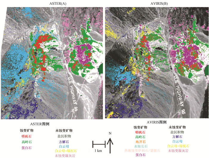
Figure 4.
Mineral recognition and mineral distribution of ASTER and AVIRIS in Cuprite area
-
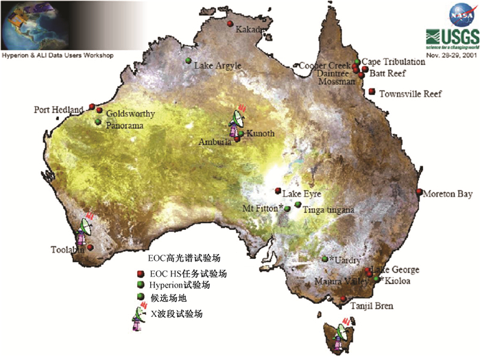
Figure 5.
Imaging spectral test site distribution in Australia
-
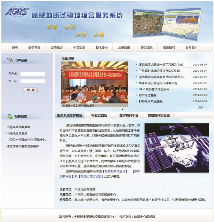
Figure 6.
Service system webpage of Hami remote sensing geological test site