
| Institute of Geomechanics, Chinese Academy of Geological Sciences | Host |
| Citation: |
SHI Wei, CHEN Hong, LI Zhen-hong, GONG Wang-bin, QIU Shi-dong. REGIONAL GEOLOGIC INVESTIGATION METHODS IN NEOTECTONIC AND ACTIVE TECTONIC AREA: EVIDENCE FROM 1: 50000 REGIONAL GEOLOGIC MAPPING IN NEOTECTONIC AND ACTIVE TECTONIC AREAS INCLUDING HONGYAZI, DABAZHAN AND QINGTONGXIALVCHANG IN NINGXIA[J]. Journal of Geomechanics, 2016, 22(4): 856-867.

|
REGIONAL GEOLOGIC INVESTIGATION METHODS IN NEOTECTONIC AND ACTIVE TECTONIC AREA: EVIDENCE FROM 1: 50000 REGIONAL GEOLOGIC MAPPING IN NEOTECTONIC AND ACTIVE TECTONIC AREAS INCLUDING HONGYAZI, DABAZHAN AND QINGTONGXIALVCHANG IN NINGXIA
-
Abstract
New requirement on regional geologic investigation was proposed by Geological Survey of China in new era. How does the regional geologic investigation in Neotectonic and active tectonic area as one of special geology and geomorphy areas be conducted in new epoch? In this work, we have carried out new geologic investigation in Ningxia area, named as "1:50000 regional geologic mapping in neotectonic and active tectonic areas including Hongyazi, Dabazhan and Qingtongxialvchang", and suggest a set of regional geologic mapping method on Neotectonic and active tectonic area. The geological mapping in new epoch should meet the requirements of the national and local economy, and yield multitasking, multidisciplinary and multilevel regional investigation fruits based on big data.
-

-
References
[1] 王国灿, 徐义贤, 陈旭军, 等.基于地表地质调查剖面网络基础上的复杂造山带三维地质调查与建模方法[J].地球科学:中国地质大学学报, 2015, 40(3):397~406. WANG Guo-can, XU Yi-xian, CHEN Xu-jun, et al. Three-dimensional geological mapping and visualization of complex orogenic belts[J]. Earth Science:Journal of China University of Geosciences, 2015, 40(3):397~406. [2] 王保良.覆盖区的岩性组合(岩相组合)填图法[J].地质通报, 2002, 21(12):890. doi: 10.3969/j.issn.1671-2552.2002.12.013 WANG Bao-liang. Mapping method of lithological association (lithofacies assemblage) in coverage area[J]. Geological Bulletin of China, 2002, 21(12):890. doi: 10.3969/j.issn.1671-2552.2002.12.013 [3] 王涛, 计文化, 胡建民, 等.专题地质填图及有关问题讨论[J].地质通报, 2016, 35(5):633~641. WANG Tao, JI Wen-hua, HU Jian-min, et al. Geological mapping for special issues and a discussion on related topics[J]. 2016, 35(5):633~641. [4] 胡健民.特殊地质地貌区填图试点[R].北京:地质力学研究所, 2014. HU Jian-min. Geological mapping pilot for special geological and geomorphical area[R]. Beijing, 2014. [5] 国家地震局鄂尔多斯周缘活动断裂系课题组.鄂尔多斯周缘活动断裂系[M].北京:地震出版社, 1988:1~328. The Research Group on"Active fault system around Ordos Massif" in State Seismological Bureau. Active fault system around Ordos Massif[M].Beijing:Seismological Press, 1988:1~328. [6] 陈虹, 胡健民, 公王斌, 等.青藏高原东北缘牛首山-罗山断裂带新生代构造变形与演化[J].地学前缘, 2013, 20(4):18~35. CHEN Hong, HU Jian-min, GONG Wang-bin, et al. Cenozoic deformation and evolution of the Niushoushan-Luoshan fault zone in the northeast margin of the Tibet Plateau[J]. Earth Science Frontiers, 2013, 20(4):18~35. [7] Chen H, Hu J M, Gong W B, et al. Characteristics and conversion mechanism of Late Cenozoic structural deformation for Niushoushan-Luoshan fault Zone at northeastern margin of the Tibetan Plateau[J]. Journal of Asian Earth Sciences, 2015, 114:73~88. doi: 10.1016/j.jseaes.2015.06.034 [8] Shi W, DONG S W, LIU Y, et al. Cenozoic tectonic evolution of the South Ningxia region, northeastern Tibetan Plateau inferred from new structural investigations and fault kinematic analyses[J]. Tectonophysics, 2015, 649:139~164. doi: 10.1016/j.tecto.2015.02.024 [9] Wang W T, Zhang P Z, Kirby E. A revised chronology for Tertiary sedimentation in the Sikouzi basin:Implications for the tectonic evolution of the northeastern corner of the Tibetan Plateau[J]. Tectonophysics, 2011, 505:100~114. doi: 10.1016/j.tecto.2011.04.006 [10] 黄兴富, 施炜, 李恒强, 等.银川盆地新生代构造演化:来自银川盆地主边界断裂运动学的约束[J].地学前缘, 2013, 20(4):199~210. HUANG Xing-fu, SHI Wei, LI Heng-qiang, et al. Cenozoic tectonic evolution of the Yinchuan Basin:Constraints from the deformation of its boundary faults[J]. Earth Science Frontiers, 2013, 20(4):199~210. [11] 何宏林.活动断层填图中的航片解译问题[J].地震地质, 2011, 33(4):938~950. HE Hong-lin. Some problem of aerial photo interpretation in active fault mapping[J]. Seismology and Geology, 2011, 33(4):938~950. [12] 叶梦旎, 张绪教, 叶培盛, 等.SPOT6与无人机航测技术在第四纪地质及活动构造填图中的应用——以内蒙古1:50000呼勒斯太苏木等四幅填图试点为例[J].地质力学学报, 2016, 22(2):366~378. YE Meng-ni, ZHANG Xu-jiao, YE Pei-sheng, et al. Application of Spot6 and the uavaerial technology in Quaternary geology and tectonic mapping:Taking the 1:50000 mapping pilot of the Hulesitai area, Inner Mongolia as an example[J]. 2016, 22(2):366~378. [13] 施炜, 刘源, 刘洋, 陈鹏, 陈龙, 岑敏, 黄兴富, 李恒强.青藏高原东北缘海原断裂带新生代构造演化[J].地学前缘, 2013, 20(4):1~17. SHI Wei, LIU Yuan, LIU Yang, et al. Cenozoic evolution of the Haiyuan fault zone in the northeast marigin of the Tibetan Plateau[J]. Earth Science Fruontiers, 2013, 20(4):1~17. [14] 刘少峰, 王陶, 张会平, 等.数字高程模型在地表过程研究中的应用[J].地学前缘, 2005, 12(1):303~309. LIU Shao-feng, WANG Tao, ZHANG Hui-ping, et al. Application of digital elevation model to surficial process research[J]. Earth Science Frontiers, 2005, 12(1):303~309. [15] 施炜.黄河中游晋陕峡谷的DEM流域特征分析及其新构造意义[J].第四纪研究, 2008, 28(2):288~298. SHI Wei. DEM drainage analysis of the Shanxi-Shaanxi gorge in the middle reaches of the Huanghe River and its neotectonic implications[J]. Quaternary Sciences, 2008, 28(2):288~298. [16] Huiping Zhang, Peizhen Zhang, Jean-Daniel Champagnac, et al. Pleistocene drainage reorganization driven by the isostatic response to deep incision into the northeastern Tibetan Plateau[J]. Geology, 2014, 42:303~306. doi: 10.1130/G35115.1 [17] 田婷婷, 吴中海, 张克旗, 等.第四纪主要定年方法及其在新构造与活动构造研究中的应用综述[J].地质力学学报, 2013, 19(3):242~266. TIAN Ting-ting, WU Zhong-hai, ZHANG Ke-qi, et al. Overview of Quaternary methods and three application in neotectonics and active tectonics research[J]. Journal of Geomechanics, 2013, 19(3):242~266. [18] Hudnut K W, Borsa A, Glennie C, et al. High-resolution topography along surface rupture of the 16 October 1999 Hector Mine, California, earthquake (Mw7.1) from airborne laser swath mapping[J]. Bulletin of the Seismologic Society of America, 2002, 92:1570~1576. doi: 10.1785/0120000934 [19] Oskin M E, Arrowsmith J R, Corona A H, et al. Near-field deformation from the El Mayor-Cucapah earthquake revealed by differential LiDAR[J]. Science, 2012, 335:702~705. doi: 10.1126/science.1213778 [20] 任治坤, 陈涛, 张会平, 等.LiDAR技术在活动构造研究中的应用[J].地质学报, 2014, 88(6):1196~1207. REN Zhi-kun, CHEN Tao, ZHANG Hui-ping, et al. LiDAR survey in active tectonics studies:An introduction and overview[J]. Acta Geologica Sinica, 2014, 88(6):1196~1207. [21] 刘保金, 柴炽章, 酆少英, 等.第四纪沉积区断层及其上断点探测的地震方法技术——以银川隐伏活动断层为例[J].地球物理学报, 2008, 51(5):1475~1483. LIU Bao-jin, CHAI Chi-zhang, FENG Shao-ying, et al. Seismic exploration method for buried fault and its up breakpoint in Quaternary sediment area:An example of Yinchuan buried ac1tive fault[J]. Chinese Journal of Geophysics, 2008, 51(5):1475~1483. [22] 李超岭, 杨东来, 于庆文, 等.数字地质调查与填图技术方法研究[J].中国地质, 2002, 29(2):213~217. LI Chao-ling, YANG Dong-lai, YU Qing-wen, et al. Digital geological survey and mapping techniques[J]. Geology in China, 2002, 29(2):213~217. [23] 张思科, 倪晋宇, 高万里, 等.三维地质建模技术方法研究——以东昆仑造山带为例[J].地质力学学报, 2009, 15(2):201~208. ZHANG Si-ke, NI Jin-yu, GAO Wan-li, et al. Study on the technology and method of 3D geological modeling:A case study of the east Kunlun orogenic belt[J]. Journal of Geomechanics, 2009, 15(2):201~208. -
Access History
Figures(5)

Export File
Citation
SHI Wei, CHEN Hong, LI Zhen-hong, GONG Wang-bin, QIU Shi-dong. REGIONAL GEOLOGIC INVESTIGATION METHODS IN NEOTECTONIC AND ACTIVE TECTONIC AREA: EVIDENCE FROM 1: 50000 REGIONAL GEOLOGIC MAPPING IN NEOTECTONIC AND ACTIVE TECTONIC AREAS INCLUDING HONGYAZI, DABAZHAN AND QINGTONGXIALVCHANG IN NINGXIA[J]. Journal of Geomechanics, 2016, 22(4): 856-867.
Format
Content
 DownLoad:
-
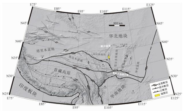
Figure 1.
Geologic Outline of the Ningxia regional geologic mapping in Neotectonic and active tectonic area
-
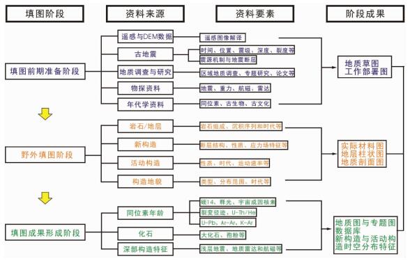
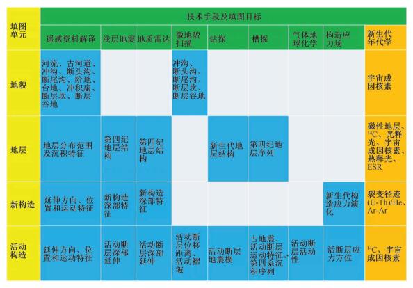
Figure 2.
Technology roadmap of 1:50000 regional geologic mapping in neotectonic and active tectonic area
-
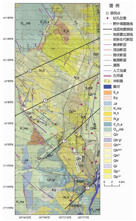
Figure 3.
Work-plan map of 1:50000 regional geologic mapping in neotectonic and active tectonic area
-
Figure 4.
Work program of 1:50000 regional geologic mapping in neotectonic and active tectonic area
-
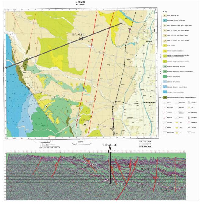
Figure 5.
Investigation of buried faults based on shallow seismic reflection and drilling