
| Institute of Geomechanics, Chinese Academy of Geological Sciences | Host |

| Citation: |
QI Xin, HUANG Bo-lin, LIU Guang-ning, WANG Shi-chang. LANDSLIDE SUSCEPTIBILITY ASSESSMENT IN THE THREE GORGES AREA, CHINA, ZIGUI SYNCLINAL BASIN, USING GIS TECHNOLOGY AND FREQUENCY RATIO MODEL[J]. Journal of Geomechanics, 2017, 23(1): 97-104.

|
LANDSLIDE SUSCEPTIBILITY ASSESSMENT IN THE THREE GORGES AREA, CHINA, ZIGUI SYNCLINAL BASIN, USING GIS TECHNOLOGY AND FREQUENCY RATIO MODEL
-
Abstract
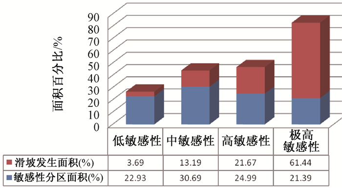
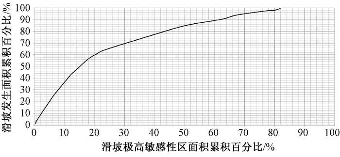
The Three Gorgesarea, China, Zigui synclinal basin is selected as a case study in this paper. Based on the field of landslide mapping, in the frequency ratio model, slope angle, lithology, rivers, roads, aspect and beeding-aspect this six assessment factors are considered to assess landslide susceptibility by overlaying analysis using GIS technology to calculate the contribution rate separately, Ultimately, landslide susceptibility area is divided into four partitions. The results shows that the vey high susceptibility area accounts for 21.39 percent and landslide area accounts for 61.44 percent. high susceptibility area accounts for 24.99 percent and landslide area accounts for 21.67 percent. Moderate susceptibility area accounts for 30.66 percent and landslide area accounts for13.19 percent. Low susceptibility area accounts for 22.93 percent and landslide area accounts for 3.69 percent. The cumulative percentage curve of landslide susceptibility area shows that the results are highly accurant and reliable, what to provide scientific support for the government about disaster prevention and reducing engineering, and provide scientific basis to landslide forecast and management.
-

-
References
[1] Aleotti P, Chowdhury R. Landslide hazard assessment: Summary review and new perspectives[J]. Bulletin of Engineering Geology and the Environment, 1999, 58(1): 21~44. doi: 10.1007/s100640050066 [2] Saha A K, Gupta R P, Sarkar I, et al. An approach for GIS-based statisticallandslidesusceptibility zonation: Witha case study in the Himalayas[J]. Landslides, 2005, 2(1): 61~69. doi: 10.1007/s10346-004-0039~8 [3] Fell R, Corominas J, Bonnard C, et al. Guidelines for landslide susceptibility, hazard and risk zoning for land-use planning[J]. Engineering Geology, 2008, 102(3/4): 99~111. [4] Guzzetti F, Carrarra A, Cardinali M, et al. Landslide hazard evaluation: A review of current techniques and their application in a multiscale study, Central Italy[J]. Geomorphology, 1999, 31:181~216. doi: 10.1016/S0169~555X(99)00078~1 [5] Rowbotham D, DudychaD N. GIS modeling of slope stability in PhewaTal watershed, Nepal[J]. Geomorphology, 1998, 26:151~170. doi: 10.1016/S0169~555X(98)00056~7 [6] Lee S, Min K. Statistical analysis of landslide susceptibility at Yongin, Korea[J]. Environ Geol, 2001, 40:1095~1113. doi: 10.1007/s002540100310 [7] DonatiL, Turrini M C. An objective method to rank the importance of the factors predisposing to landslides with the GIS methodology: Application to an area of the Apennines (Valnerina, Perugia, Italy)[J]. Eng Geol, 2002, 63: 277~289. doi: 10.1016/S0013~7952(01)00087~4 [8] Lee S, Choi U. Development of GIS-based geological hazard information system and its application for landslide analysis in Korea[J]. Geosci J, 2003, 7: 243~252. doi: 10.1007/BF02910291 [9] Atkinson P M, Massari R. Generalized linear modeling of susceptibility to landsliding in the central Apennines, Italy[J]. Computers & Geosciences, 1998, 24(4): 373~385. [10] Dai F C, Lee C F, Li J, et al. Assessment of landslides susceptibility on the natural terrain of Lantau Island, Hongkong[J]. Environ Geol, 2001, 40: 381~391. doi: 10.1007/s002540000163 [11] Dai F C, Lee C F. Landslide characteristics and slope instability modeling using GIS, Lantau Island, Hongkong[J]. Geomorphology, 2002, 42: 213~228. doi: 10.1016/S0169~555X(01)00087~3 [12] 唐川, 朱静.GIS支持下的地震诱发滑坡危险区预测研究[J].地震研究, 2001, 24(1): 73~81. TANG Chuan, ZHU Jing. GIS based earthquake triggered landslide hazard prediction[J]. Journal of Seismological Research, 2001, 24(1): 73~81. [13] 许冲, 戴福初, 姚鑫, 等.基于GIS与确定性系数分析方法的汶川地震滑坡易发性评价[J].工程地质学报, 2010, 18(1): 15~26. XU Chong, DAI Fu-chu, YAO Xin, et al. GIS platform and certainty factor analysis method based Wenchuan earthquake-induced landslide susceptibility evaluation[J]. Journal of Engineering Geology, 2010, 18(1): 15~26. [14] 兰恒星, 伍法权, 周成虎, 等.基于GIS的云南小江流域滑坡因子敏感性分析[J].岩石力学与工程学报, 2002, 21(10): 1500~1506. doi: 10.3321/j.issn:1000~6915.2002.10.014 LAN Heng-xing, WU Fa-quan, ZHOU Cheng-hu, et al. Analysis on susceptibility of GIS based landslide triggering factors in Yunnan Xiaojiang watershed[J]. Chinese Journal of Rock Mechanics and Engineering, 2002, 21(10): 1500~1506. doi: 10.3321/j.issn:1000~6915.2002.10.014 [15] Maharaj R J. Landslide processes and landslide susceptibility analysis from an upland watershed: A case study from St. Andrew, Jamaica, WestIndies[J]. Engineering Geology, 1993, 34(1/2):53~79. [16] Kamp U, Growley B J, Khattak G A, et al. GIS based landslide susceptibility mapping for the 2005 Kashmir earthquake region[J]. Geomorphology, 2008, 101(4): 631~642. doi: 10.1016/j.geomorph.2008.03.003 [17] Tang C, Zhu J, Li W, et al. Rainfall-triggered debris flows following the Wenchuan earthquake[J]. Bulletin of Engineering Geology and the Environment, 2009, 68(2): 187~194. doi: 10.1007/s10064-009-0201~6 [18] Carrara A, Guzzetti F, Cardinali M, et al. Use of GIS technology in the prediction and monitoring of landslide hazard[J]. Natural Hazards, 1999, 20(2/3): 117~135,5. doi: 10.1023/A:1008097111310 [19] Kouli M, Loupasakis C, Soupios P, et al. Landslide hazard zonation in high risk areas of Rethymno Prefecture, Crete Island, Greece[J]. Natural Hazards, 2010, 52(3): 599~621. doi: 10.1007/s11069-009~9403~2 -
Access History
Figures(12)
Tables(2)

Export File
Citation
QI Xin, HUANG Bo-lin, LIU Guang-ning, WANG Shi-chang. LANDSLIDE SUSCEPTIBILITY ASSESSMENT IN THE THREE GORGES AREA, CHINA, ZIGUI SYNCLINAL BASIN, USING GIS TECHNOLOGY AND FREQUENCY RATIO MODEL[J]. Journal of Geomechanics, 2017, 23(1): 97-104.
Format
Content
 DownLoad:


-
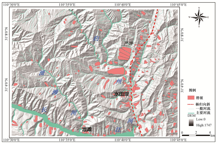
Figure 1.
The distribution map of landslides in the study area
-
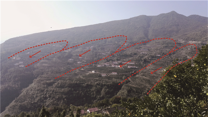
Figure 2.
The landslide group of Yanping
-
Figure 3.
Topographic slope classification map of the study area
-
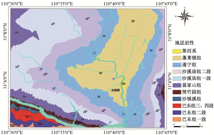
Figure 4.
The Lithology classification figure of the study area
-
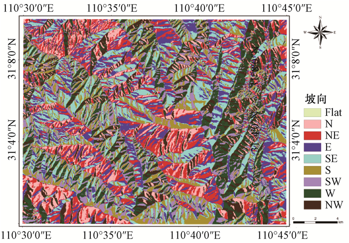
Figure 5.
The aspect classification figure of the study area
-
Figure 6.
Stream Buffer classification figure of the study area
-
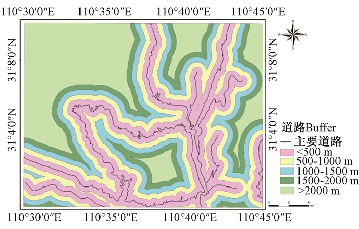
Figure 7.
Road Buffer classification figure of the study area
-
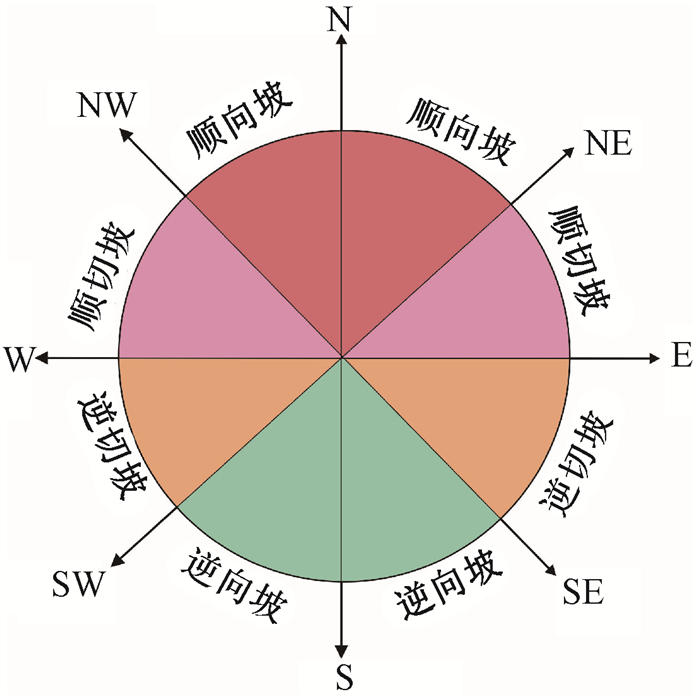
Figure 8.
The bedding-aspect classification criteria
-
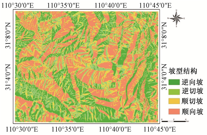
Figure 9.
The bedding-aspect classification figure of the study area
-
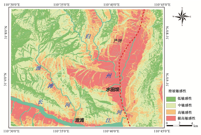
Figure 10.
The zoning map of landslide susceptibility
-
Figure 11.
The percentage histogram between zoning area of landslide susceptibility and landslide area
-
Figure 12.
Requency ratio model shows cumulative percentage curve of landslide sensitive area