

| Citation: |
YANG Xingchen, YE Peisheng, CAI Maotang, CHANG Pengyuan, YOU Baojie, LI Chenglu, YE Mengni, CAI Huihui. Variation of lake water level recorded by grain sizes of sediments from Hetao Paleolake since 150ka[J]. Geological Bulletin of China, 2017, 36(6): 1043-1050.

|
Variation of lake water level recorded by grain sizes of sediments from Hetao Paleolake since 150ka
-
Abstract
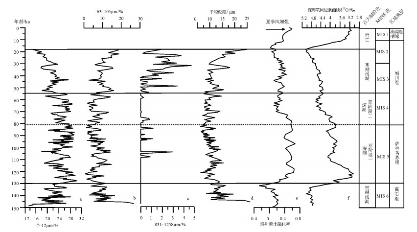
Based on size data of Bingfanggou lacustrine sedimentation section, which lies in Hetao basin piedmont, combined with chronologic test of 14C and OSL, the authors comparatively analyzed sediment particle size sensitivity and frequency curve characteris-tics, and made inversion of the lake water level change of Hetao Paleolake since 150ka.The result indicates that the lake water level change of Hetao Paleolake has gone through four stages:① Initial forming stage(150~130ka):Hetao Paleolake was in a shallow lake environment, sediment particle sizes were from coarse to fine, and the water level of the lake was in rising period; ② Developing stage (130~54ka):the lake surface was higher in deep water environment early, sediment particle sizes gradually became thicker and the lake surface declined; ③ Contraction stage (54~18ka):the lake water level dropped rapidly, the fine-grained sediments decreased, and the coarse-grained sediments increased; ④ Demise stage (18ka-now):due to the influence of active faults in piedmont, the Yinshan Mountain uplifted rapidly, the lake atrophied swiftly, the top of the lacustrine strata was covered by diluvial and alluvial materials be-tween the mountains.The main factors controlling the water level change of the paleolake seem to have been the tectonic movement and abrupt change of climate environment.
-
Keywords:
- Hetao Paleolake /
- grain size /
- lake level /
- 14C /
- OSL
-

-
References
[1] 孙千里, 周杰, 肖举乐.岱海沉积物粒度特征及其古环境意义[J].海洋地质与第四纪地质, 2001, 21(1):93-95. [2] Shuman B, Bravo J, Kaye J, et al. Late Quaternary water-level varia-tions and vegetation history at Crooked Pood, Southeastern Massa-chusetts[J]. Quaternary Research, 2001, 56:401-410. doi: 10.1006/qres.2001.2273 [3] 陈敬安, 万国江, 张峰, 等.不同时间尺度下的湖泊沉积物环境记录-以沉积物粒度为例[J].中国科学(D辑), 2003, 33(6):563-568. [4] 施祺, 王建民, 陈发虎.石羊河古终端湖泊沉积物粒度特征与沉积环境初探[J].兰州大学学报, 1999, 35(1):194-198. [5] 李志忠, 海鹰, 罗若愚, 等.乌鲁木齐河下游地区湖泊沉积物的粒度特征与沉积环境[J].干早区研究, 2000, 17(3):1-5. [6] Li G Q, Jin M, Chen X M, et al. Environmental changes in the Ulan Buh Desert, southern Inner Mongolia, China since the middle Pleis-tocene based on sedimentology. chronology and proxy indexes[J]. Quaternary Science Reviews, 2015, 128:69-80. doi: 10.1016/j.quascirev.2015.09.010 [7] 陈发虎, 范育新, Madsen D B, 等.河套地区新生代湖泊演化与"吉兰泰-河套"古大湖形成机制的初步研究[J].第四纪研究, 2008, 28(5):866-873. [8] 蒋复初, 王书兵, 李朝柱, 等.内蒙古托克托台地湖相地层及其初步意义[J].第四纪研究, 2012, 32(5):866-873. [9] 李建彪, 冉勇康, 郭文生.呼包盆地第四纪地层与环境演化[J].第四纪研究, 2007, (4):632-644. [10] 贾铁飞, 银山, 赵明, 等.黄河托克托段早中更新世湖相地层剖面的建立及其意义[J].内蒙古师大学报自然科学(汉文)版, 2001, 30(1):74-78. [11] Ye Z Y, Guo K Z, Zhao S Y, et al. The Current Development and Focal Points in Short-term Water-saving Agriculture in HetaoIrri-gation District[J]. China Rural Water and Hydropower, 2010, 6:81-84. [12] 公王斌, 胡健民, 李振宏, 等.河套盆地西缘山前低台地沉积特征对"吉兰泰-河套"古湖消退过程及其控制因素的指示意义[J].地学前缘, 2013, 20(4):190-198. [13] Boulay S, Colin C, Trentesaux A, et al. Mineralogy and Sedimen-tology of Pleistocene Sediment in the South China Sea(ODP Site1144)[J]. Proceedings of the Ocean Drilling Program, 2002, 184(1):1-21. [14] 汪海斌, 陈发虎, 张家武.黄土高原西部地区黄土粒度的环境指示意义[J].中国沙漠, 2002, 22(1):21-26. [15] Prins M A, Postma G, Cleveringa C. Controls on Terrigenous Sedi-ment Supply to the Arabian Sea during the Late Quaternary:The Makran Continental slope[J]. Marine Geology, 2000, 169(3):351-371. [16] 孙东怀, 安芷生, 苏瑞侠, 等.古环境中沉积物粒度组分分离的数学方法及应用[J].自然科学进展, 2001, 11(3):269-276. [17] 王君波, 朱立平.藏南沉错沉积物的粒度特征及其古环境意义[J].地理科学进展, 2002, 21(5):459-467. doi: 10.11820/dlkxjz.2002.05.007 [18] 李保生, 靳鹤龄, 祝一志, 等.萨拉乌苏河流域第四系岩石地层及其时间界限[J].沉积学报, 2004, 22(4):676-682. [19] Jia L Y, Zhang X J, Ye P S, et al. Development of the Alluvial and Lacustrine Terraces on the Northern Margin of the Hetao Basin, Inner Mongolia, China:Implication for the Evolution of the Yel-low River in the Hetao Area since the Late Pleistocene[J]. Geomor-phology, 2016, 263:87-98. doi: 10.1016/j.geomorph.2016.03.034 [20] Sun Y B, Clemens S C., An Z S, et al, Astronomical Timescale and Palaeoclimatic Iimplication of Stacked 3.6-Myr Monsoon Records from the Chinese Loess Plateau[J]. Quaternary Science Reviews, 2006, 25(1/2):33-48. [21] 陈发虎, 范育新, 春喜, 等.晚第四纪"吉兰泰-河套"古大湖的初步研究[J].科学通报, 2008, 10(53):1207-1219. [22] 李建彪, 冉勇康, 郭文生.河套盆地托克托台地湖相层研究[J].第四纪研究, 2005, 25(5):630-639. [23] 李建彪. 河套盆地晚第四纪成湖环境变化与构造活动研究[D]. 中国地震局地质研究所博士学位论文, 2006. [24] 马保起, 李德文, 郭文生.晚更新世晚期呼包盆地环境演化与地貌响应[J].第四纪研究, 2004, 24(6):630-637. [25] 鹿化煜, 周亚利, Mason J, 等.中国北方晚第四纪气候变化的沙漠与黄土记录——以光释光年代为基础的直接对比[J].第四纪研究, 2006, 26(6):888-894. [26] 何泽新, 张绪教, 贾丽云, 等.内蒙古狼山山前台地成因及其新构造运动意义[J].现代地质, 2014, 28(1):98-108. -
Access History
Figures(5)
Tables(2)

Export File
Citation
YANG Xingchen, YE Peisheng, CAI Maotang, CHANG Pengyuan, YOU Baojie, LI Chenglu, YE Mengni, CAI Huihui. Variation of lake water level recorded by grain sizes of sediments from Hetao Paleolake since 150ka[J]. Geological Bulletin of China, 2017, 36(6): 1043-1050.
Format
Content
 DownLoad:
-
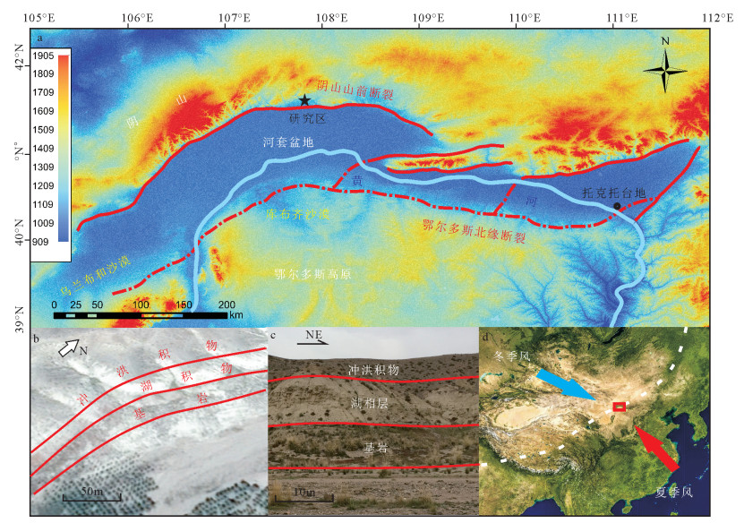
Figure 1.
Location of the study area
-
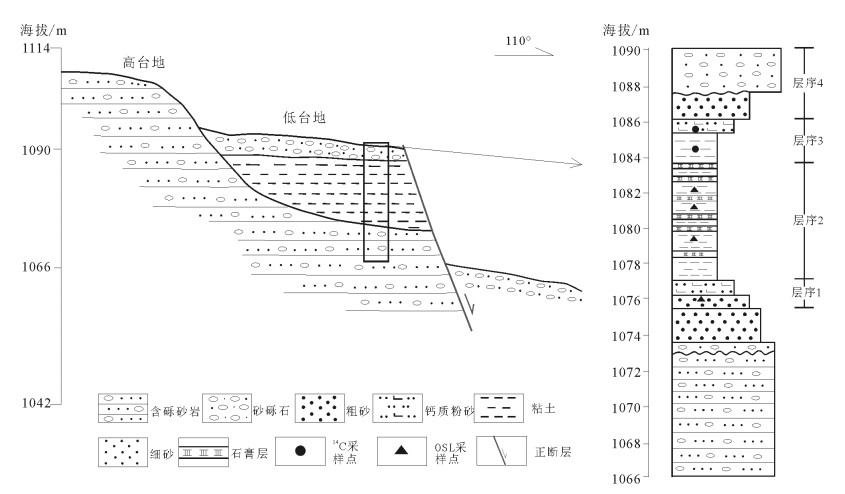
Figure 2.
Composite profile of the location of Bingfanggou section
-
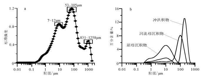
Figure 3.
Maps of particle size-standard deviation of sediments in Hetao Paleolake (a) and characteristics of particle size frequency curves of sediments in Hetao basin (b)
-
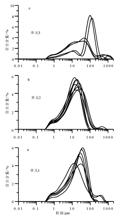
Figure 4.
Particle size distribution of sediments in Hetao Paleolake
-
Figure 5.
Comparison of particle size records of Hetao Paleolake and other paleoclimate records