
| Citation: |
ZHANG Yongting, XU Youning, LIANG Wei, WEI Caiyong, LI Qiaomin, YANG Xueru, BAI Jianhong. Technical methods for colliery subsidence disaster monitoring using UAV LiDAR: A case study of the Maliantai colliery, Ningdong coal base, Ningxia[J]. Geological Bulletin of China, 2018, 37(12): 2270-2277.

|
Technical methods for colliery subsidence disaster monitoring using UAV LiDAR: A case study of the Maliantai colliery, Ningdong coal base, Ningxia
-
Abstract
Exploring advanced technology of coal-mining subsidence disaster monitoring is an important task to promote the monitoring better. Colliery subsidence disaster monitoring using UAV LiDAR is a new technology of low-flying 3D measurement composed of UAV and LiDAR. In this study, the authors chose the typical subsidence area of Maliantai colliery, Ningdong coal base in Ningxia as the study area, and obtained point cloud data of two time periods in April and August 2017 in the study area based on UAV LiDAR data. The authors obtained the 3D stereogram of colliery subsidence disaster by information extraction and 3D modeling and discovered 3 colliery subsidence disaster areas. Also, using a certain number of existent leveling points and GPS automatic monitoring data, the authors evaluated the accuracy of the model. The results show that the technical methods of colliery subsidence disaster monitoring using UAV LiDAR data meet the requirements of relevant specification. The methods have such features as flexibility, low cost, high efficiency and high precision, and have wide popularization and application value in future.
-
Keywords:
- multi-rotor UAV /
- UAV LiDAR /
- DEM /
- subsidence disaster monitoring /
- Maliantai colliery of Ningdong
-

-
References
[1] 孙张涛, 范景辉, 王如意, 等.基于高分辨率SAR数据的地面沉降监测——以印度尼西亚雅加达为例[J].地质通报, 2015, 34(10):1910-1917. doi: 10.3969/j.issn.1671-2552.2015.10.015 [2] 刘超.西安地铁二号线南段地面沉降成因分析[D].长安大学硕士学位论文, 2012. http://cdmd.cnki.com.cn/Article/CDMD-10710-1013018094.htm [3] 周飞飞.《全国地面沉降防治规划(2011-2020年)》解读——访国土资源部地质环境司副司长陶庆法[J].中国应急管理, 2012, 3:56-59. [4] 陈炳乾.面向矿区沉降监测的InSAR技术及应用研究[D].中国矿业大学博士学位论文, 2015. [5] 徐友宁.矿山地质环境调查研究现状及展望[J].地质通报, 2008, 8:1235-1244. doi: 10.3969/j.issn.1671-2552.2008.08.021 [6] 刘毅.灾害性地面沉降分析[J].地质灾害与防治, 1990, 4:9-12. [7] 何芳, 徐友宁, 陈华清, 等.西北地区矿山地质灾害的现状及其时空分布特征[J].地质通报, 2008, 27(8) 1245-1255. doi: 10.3969/j.issn.1671-2552.2008.08.022 [8] 王婷婷.基于三维激光扫描技术的地表变形监测[D].山东科技大学硕士学位论文, 2011. http://cdmd.cnki.com.cn/Article/CDMD-10424-1012276966.htm [9] 董秀军.三维激光扫描技术获取高精度DTM的应用研究[J].工程地质学报, 2007, 3:428-432. doi: 10.3969/j.issn.1004-9665.2007.03.022 [10] Strouth A, Burk R L, Eberhardt E. The Afternoon Creek rockslide near Newhalem, Washington[J]. Landslides, 2006, 3(2):175-179. doi: 10.1007/s10346-005-0030-z [11] Hsiao K H, Liu J K, Yu M F. Change detection of landslide terrains using ground-based LIDAR data[C]//International Archives of Photogrammetry and Remote Sensing. Istambul, Turkey, 2004. [12] Bitelli G, Dubbini M, Zanutta A. Terrestrial laser scanning and digital photogrammetry techniques to monitor landslide bodies[J]. International Archives of Photo-grammetry, Remote Sensing and Spatial Information Sciences, 2004, 35(Part B5):246-251. [13] 姚艳丽, 蒋胜平, 王红平.基于地面三维激光扫描仪的滑坡整体变形监测方法[J].测绘地理信息, 2014, 39(1):50-53. [14] 陈弘奕, 胡晓斌, 李崇瑞.地面三维激光扫描技术在变形监测中的应用[J].测绘通报, 2014, 12:74-77. [15] 李秋, 秦永智, 李宏英, 等.激光三维扫描技术在矿区地表沉陷监测中的应用研究[J].煤炭工程, 2006, 4:97-99. [16] 徐进军, 王海城, 罗喻真.基于三维激光扫描的滑坡变形监测与数据处理[J].岩土力学, 2010, 31(7):2187-2191. [17] 袁枫.机载LiDAR数据处理与土地利用分类研究[D].中国矿业大学(徐州)博士学位论文, 2010. [18] Aleksey Boyko, Thomas Funkhouser. Extracting roads from dense point clouds in large scale urban environment[J]. Jounal of Photogrammetry and Remote Sensing, 2011, 66(5):2-12. [19] 林昀, 吴敦, 李丹农.基于机载激光雷达的高精度电力巡线测量[J].城市勘测, 2011, 5:71-74. [20] 韩立, 余代俊, 何延龙. LiDAR在四川某地电力选线项目中的应用[J].测绘与空间地理信息, 2014, 4:86-88. [21] 李红, 肖国强, 杨吉龙, 等.天津滨海新区地面沉陷层位的精准识别与沉陷过程重建[J].地质通报, 2016, 35(10):1646-1652. doi: 10.3969/j.issn.1671-2552.2016.10.012 [22] 梁周雁, 赵富燕, 孙文潇.基于三维激光扫描技术的地表变形监测方法研究[J].测绘与空间地理信息, 2017, 6:213-214. [23] 陈利明, 张巍, 于虹, 等.无人机载LiDAR系统在电力线巡检中的应用[J].测绘通报, 2017, S1:176-178. [24] 李强, 邓辉, 周毅.三维激光扫描在矿区地面沉陷变形监测中的应用[J].中国地质灾害与防治学报, 2014, 3:119-124. [25] 石友峰.三维激光扫描技术在测量中的应用研究[D].长安大学硕士学位论文, 2007. http://cdmd.cnki.com.cn/Article/CDMD-11941-2009211328.htm [26] 杨军, 曾翠华, 郑荣霞. PolyWorks在逆向工程点云数据处理中的应用[J]. CAD/CAM与制造业信息化, 2008, 11:55-57. [27] 宫丽玮, 张毅, 闫利.基于Cyclone和PolyWorks的三维建模实现[J].地理空间信息, 2012, 5:38-40. doi: 10.3969/j.issn.1672-4623.2012.02.014 [28] 张舒, 吴侃.三维激光扫描技术在沉陷监测中应用的若干问题探讨[C]//第七届全国矿山测量学术会议论文集.北京: 中国煤炭协会, 2007. http://cpfd.cnki.com.cn/Article/CPFDTOTAL-ZGMT200711003012.htm -
Access History
Figures(7)
Tables(4)

Export File
Citation
ZHANG Yongting, XU Youning, LIANG Wei, WEI Caiyong, LI Qiaomin, YANG Xueru, BAI Jianhong. Technical methods for colliery subsidence disaster monitoring using UAV LiDAR: A case study of the Maliantai colliery, Ningdong coal base, Ningxia[J]. Geological Bulletin of China, 2018, 37(12): 2270-2277.
Format
Content
 DownLoad:

-
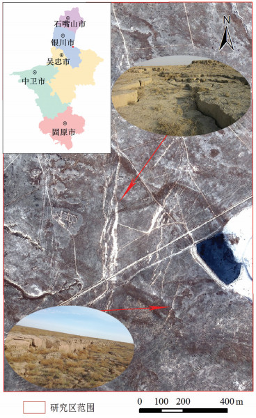
Figure 1.
Satellite image map of the study area
-
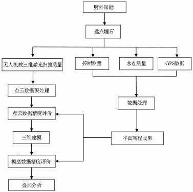
Figure 2.
Flow chart of scanning measurement of airborne LiDAR
-
Figure 3.
Ground subsidence monitoring points and flight route layout map
-
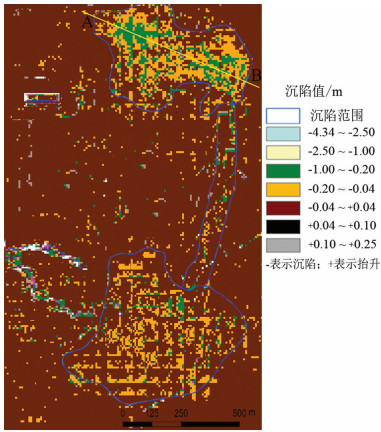
Figure 4.
Distribution of subsidence intensity
-
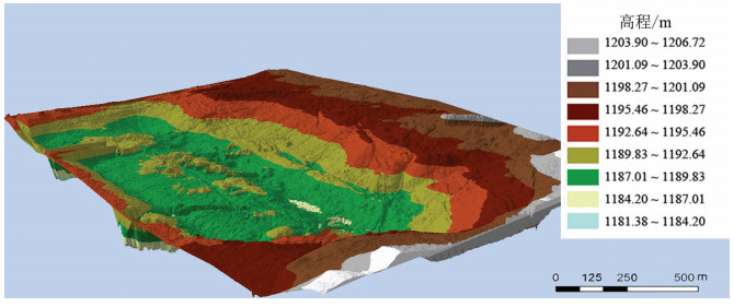
Figure 5.
3D effect map of the study area
-
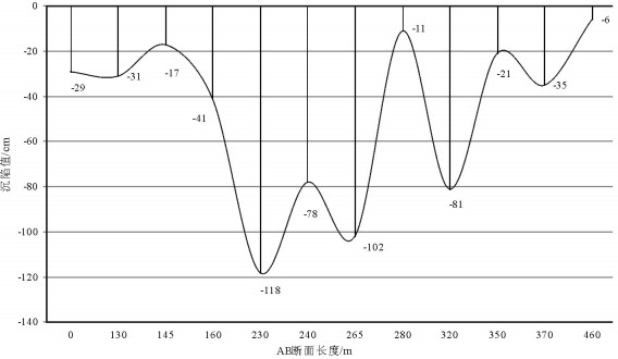
Figure 6.
Profile of AB section in the north subsidence area of the study area
-
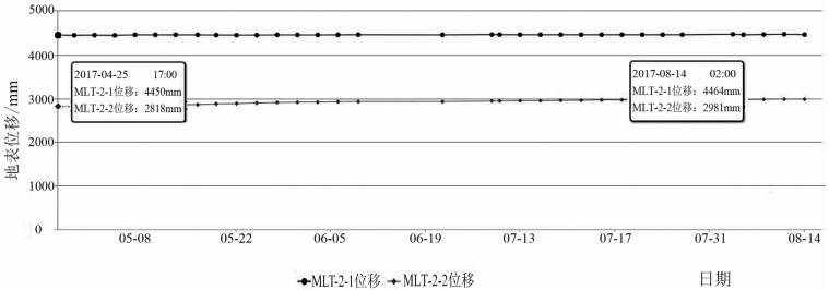
Figure 7.
Settlement curve of GPS automatic monitoring point in the study area from April to August, 2017