
| Citation: |
GAO Guanjie, HOU Enke, XIE Xiaoshen, XU Youning, WEI Qiming, LIU Jiangbin. The monitoring of ground surface subsidence related to coal seams mining in Yangchangwan coal mine by means of unmanned aerial vehicle with quad-rotors[J]. Geological Bulletin of China, 2018, 37(12): 2264-2269.

|
The monitoring of ground surface subsidence related to coal seams mining in Yangchangwan coal mine by means of unmanned aerial vehicle with quad-rotors
-
Abstract
The small UAV is an important tool in geological survey with the advantages of low cost and flexible operation. The monitoring of surface subsidence and deformation is a key to controlling the surface movement and deformation related to coal seams mining and subsidence. This paper focuses on the investigation of coal mining subsidence monitoring in the Y120212 working face in Yangchangwan coal mine, by the process of field reconnaissance and controlling point layout, UAV route planning and execution, 4D product production process and monitoring methods, so as to apply unmanned aerial vehicle remote sensing technology to monitoring the mine geological collapse. The research shows that the maximum subsidence value of the Y120212 working surface reaches 6.5m by comparison of the DSM processing of unmanned aerial vehicle (UAV) remote sensing technology and multi period ground elevation. A comparative study of the unmanned aerial vehicle remote sensing technology shows that it can monitor the surface subsidence deformation related to coal mining subsidence area. The technology is also a new means for monitoring the ground subsidence of the coal mine.
-

-
References
[1] 张飞.基于DIn-SAR技术的淮南采煤沉陷区地面沉降监测研究[D].南京大学硕士学位论文, 2012. http://cdmd.cnki.com.cn/Article/CDMD-10284-1014451362.htm [2] 赵兵朝, 刘宾, 王建文, 等.柠条塔煤矿叠置开采地表岩移参数分析[J].煤矿安全, 2016, 47(9):213-216. [3] 赵兵朝, 刘飞, 凡奋元, 等.黄土沟壑区下斜交叠置开采地表下沉系数研究[J].矿业安全与环保, 2016, 43(5):54-57. doi: 10.3969/j.issn.1008-4495.2016.05.013 [4] 陈炳乾, 邓喀中, 范洪冬.基于DIn-SAR技术和SVR算法的开采沉陷监测与预计[J].中国矿业大学学报, 2014, 43(5):880-886. [5] 王小兵.基于DIn-SAR技术的矿山开采沉陷监测研究现状[J].金属矿山, 2015, (S1):65-71. [6] 独知行, 阳凡林, 刘国林, 等. GPS与In-SAR数据融合在矿山开采沉陷形变监测中的应用探讨[J].测绘科学, 2007, 1:55-57, 162. [7] 李强, 邓辉, 周毅.三维激光扫描在矿区地面沉陷变形监测中的应用[J].中国地质灾害与防治学报, 2014, 25(1):119-124. [8] 杨化超, 邓喀中, 张书毕, 等.数字近景摄影测量技术在矿山地表沉陷监测中的应用研究[J].中国图像图形学报, 2008, 3:519-524. [9] 曾跃.基于无人机摄影测量的地质灾害监测[D].吉林大学硕士学位论文, 2016. [10] 张玉侠, 兰鹏涛, 金元春, 等.无人机三维倾斜摄影技术在露天矿山监测中的实践与探索[J].测绘通报, 2017, S1:114-116. [11] 魏长婧, 汪云甲, 王坚, 等.无人机影像提取矿区地裂缝信息技术研究[J].金属矿山, 2012, 41(10):90-92. doi: 10.3969/j.issn.1001-1250.2012.10.024 [12] 李德仁, 李明.无人机遥感系统的研究进展与应用前景[J].武汉大学学报(信息科学版), 2014, 39(5):505-513, 540. [13] 蔡怀恩, 侯恩科, 张强骅, 等.黄土丘陵区房柱式开采地表塌陷特征及机理分析——以陕北府谷县新民镇小煤矿为例[J].地质灾害与环境保护, 2010, 21(2):101-104. doi: 10.3969/j.issn.1006-4362.2010.02.023 [14] 马露.采空地面塌陷遥感识别方法研究[D].西安科技大学硕士学位论文, 2009. http://cdmd.cnki.com.cn/Article/CDMD-10704-2009262634.htm [15] 侯恩科, 首召贵, 徐友宁, 等.无人机遥感技术在采煤地面塌陷监测中的应用[J].煤田地质与勘探, 2017, 45(6):102-110. doi: 10.3969/j.issn.1001-1986.2017.06.017 -
Access History
Figures(8)
Tables(4)

Export File
Citation
GAO Guanjie, HOU Enke, XIE Xiaoshen, XU Youning, WEI Qiming, LIU Jiangbin. The monitoring of ground surface subsidence related to coal seams mining in Yangchangwan coal mine by means of unmanned aerial vehicle with quad-rotors[J]. Geological Bulletin of China, 2018, 37(12): 2264-2269.
Format
Content
 DownLoad:
-
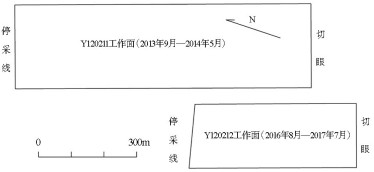
Figure 1.
The positional relationship of working face
-
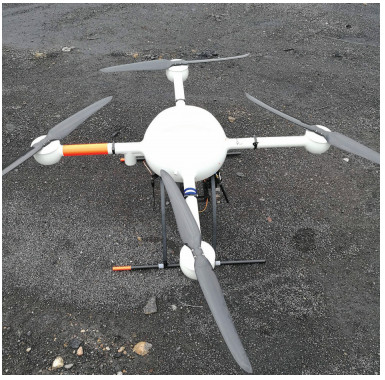
Figure 2.
MD4-1000 UAV
-
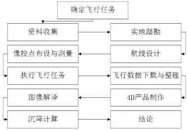
Figure 3.
The flow chart of UAV remote sensing monitoring technology
-
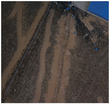
Figure 4.
Direct interpretation key
-
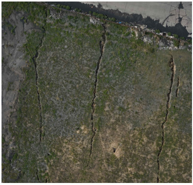
Figure 5.
Indirect interpretation key
-
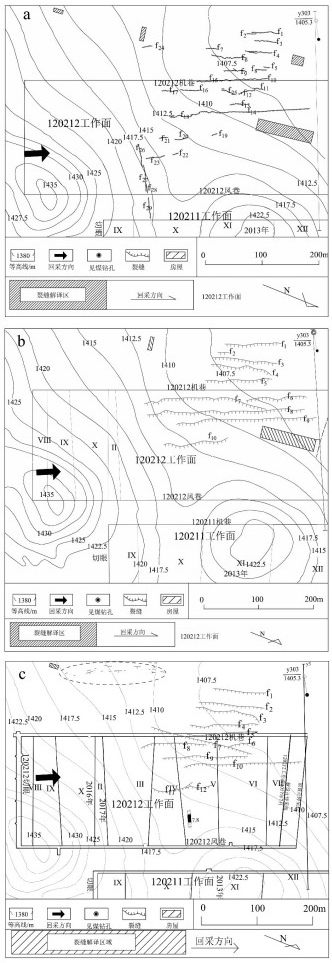
Figure 6.
The schematic diagram of crack distribution of Y120212 working face
-
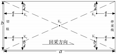
Figure 7.
The distribution of ground control points
-
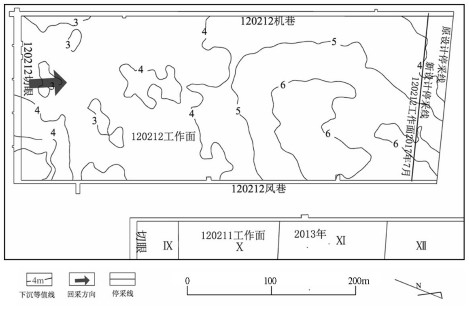
Figure 8.
The map of the sinkage isoline in Y120212 working face