
| Citation: |
WANG Yanggang, HAO Lirong, HUANG Hui, LI Yusong, ZHANG Dake, ZHANG Qinghe, LI Li, ZHANG Lin, JIHANG Zuorui. Research on geological map compilation technology based on spatial data and geological knowledge[J]. Geological Bulletin of China, 2019, 38(12): 2067-2076.

|
Research on geological map compilation technology based on spatial data and geological knowledge
-
Abstract
In order to improve the efficiency of specific compilation of geological map and reduce human workload, it is necessary to develop a new method to update the previous geological maps compiled decades ago. After studying the information technology such as AI & BigData, the authors constructed the spatial-temporal model of generalization and the intelligent model of the geological annotation. Then a new technology was developed with which small scale geological maps can be converted to general scale geological maps in a big data environment through compilation. The technology for mapping is called iMapower. Practically, the geological features, such as sedimentary rocks, intrusive rocks, volcanic rocks, metamorphic rocks and structures, can be processed intelligently, interactively, automatically with iMapower based on geological knowledge. The processing procedures include geological body merging, geoline simplification, fault generalization, feature representation, legends illustration, etc. In its application to several pilot areas such as eastern Qinghai Province, Luoyang area, Zhengzhou area and Jingjinji area, the efficiency is obviously improved. The iMapower is proved to be scientific and effective.
-

-
References
[1] 李廷栋, 刘勇, 王军, 等.略论地质图件的十大功能——纪念黄汲清先生诞辰110周年[J].地质论评, 2014, 60(3):473-485. [2] 姜作勤.美、加、澳、英等国地学数字制图技术综述[J].中国地质, 1994, 12:27-29. [3] 姜作勤, 马智民, 杨东来, 等.主要发达国家地质信息服务的政策体系及其特点[J].地质通报, 2007, 3:350-354. doi: 10.3969/j.issn.1671-2552.2007.03.013 [4] Charlie F. Modeling active database-driven cartography within GIS databases[C]//The 21st International Cartographic Conference of the International Cartographic Association. Durban, South Africa, 2003. [5] Buckly A, Frye C, Buttenfield B. An Information Model for Maps: Towards Cartographic Production from GIS Databases[EB/OL] [2018-10-24] http://icaci.org/files/documents/ICC-proceedings/ICC2005/htm/pdf/oral/TEMA1/SESSION1/AILEEN%20BUCKLEY.pdf, 2018. [6] Tomlin C D. GIS and Cartographic modeling[M]. California:Esri Press, 2012. [7] FGDC. FGDC Digital Cartographic Standard for Geologic Map Symbolization (PostScript Implementation). Reston, Virginia, Federal Geographic Data Committee, 2006. [8] VanGasselt S A N. Planetary mapping——The datamodel's perspective and GIS framework[J]. Planetary and Space Science, 2010, (59):12. [9] 陈军, 王东华, 商瑶玲, 等.国家1:50000数据库更新工程总体设计研究与技术创新[J].测绘学报, 2010, 1:7-10. [10] 王家耀, 钱海忠.制图综合知识及其应用[J].武汉大学学报(信息科学版), 2006, 5:382-386+439. [11] 王家耀, 孙群, 王光霞, 等.地图学原理与方法[M].北京:科学出版社, 2014. [12] Oosterom P V. Research and development in geo-information generalisation and multiple representation[J]. Computers, Environment and Urban Systems, 2009, 33:303-310. doi: 10.1016/j.compenvurbsys.2009.07.001 [13] Zhang X R. A Multi-Agent System For Generalization of Features Defined by Isobaths in Nautical Chart Construction[D]. Master of Philosophy, the Hong Kong Polytechnic University, 2012. [14] Ajith H, Perera C A D, Johnson C J. Expert Knowledge and Its Application in Landscape Ecology[M]. New York:Springer Science+Business Media, 2014. [15] Hamid R, Safavi M H G, Samuel Sandoval-Solis. Expert knowledge based modeling for integrated water resources planning and management in the Zayandehrud River Basin[J]. Journal of Hydrology, 2015, (528):773-789. [16] Jean-Luc Monnot P H, Dan Lee. An optimization approach to constraint-based generalization in a commodity GIS framework[M]. International Cartographic Conference, Moscow, Russia, 2007. [17] Yin J T, Chen D W, Li Y D. Smart train operation algorithms based on expert knowledge and ensemble CART for the electric locomotive[J]. Knowledge-Based Systems, 2016, (92):78-91. [18] 蓝荣钦, 杨晓梅.领域专家知识及其在空间数据挖掘中的作用[J].测绘学院学报, 2004, 2:141-144. doi: 10.3969/j.issn.1673-6338.2004.02.022 [19] 李山, 徐升华, 李冬伟.基于多Agent的专家知识资源库的构建研究[J].情报科学, 2013, 1:111-117. [20] 刘雪华, 张爽, 靳强.贝叶斯专家系统分类器中专家知识的自动提取[J].地理与地理信息科学, 2008, 4:20-24. [21] Jantien Stoter D B, Cécile Duchêne, Blanca Baella, et al. Methodology for evaluating automated map generalization in commercial software.Computers[J], Environment and Urban Systems, 2009, 33:311-324. doi: 10.1016/j.compenvurbsys.2009.06.002 [22] 钱海忠, 武芳, 王家耀.自动制图综合链理论与技术模型[J].测绘学报, 2006, 4:400-407. doi: 10.3321/j.issn:1001-1595.2006.04.019 [23] 王家耀, 武芳, 王光霞.基于地图数据库数据的自动编图系统[J].测绘通报, 1998, 9:23-25. [24] BGS. DiGMapGB digital geological maps of Great Britain Datasets[EB/OL] [2018-10-24] http://www.bgs.ac.uk/products/digitalmaps/DiGMapGBMaps.html. [25] BGS. Make-a-map[EB/OL] [2018-10-24] http://www.bgs.ac.uk/discoveringGeology/geologyOfBritain/makeamap/map.html. [26] OneGeology. Contriesinvolved[EB/OL] [2018-10-24] http://www.onegeology.org/participants/app/1gCountries.cfc?method=viewCountries. [27] OneGeology. Portal[EB/OL] [2018-10-24] http://www.onegeology.org/portal/home.html. [28] Douglas D H, Peucker T K. Algorithms for the reduction of the number of points required to represent a digitized line or its caricature[J]. Canadian Cartographer, 1973, 10(2):112-122. doi: 10.3138/FM57-6770-U75U-7727 [29] De Berg M T, Van Kreveld M, Schirra S. Topologically correct subdivision simplification using the bandwidth criterion[J]. Cartography and Geographic Information Systems, 1998, 25(4):243-257. doi: 10.1559/152304098782383007 [30] Jones C B, Bundy G L, Ware J M. Map generalization with a triangulated data structure[J]. Cartography and Geographic Information Systems, 1995, 22(4):317-331. [31] Saalfeld A. Topologically consistent line simplification with the Douglas-Peucker algorithm[J]. Cartography and Geographic Information Science, 1999, 26(1):7-18. doi: 10.1559/152304099782424901 [32] Galanda M, Weibel R. Using an energy minimization technique for polygon generalization[J]. Cartography and Geographic Information Science, 2003, 30(3):259-275. [33] Chopard B. A cellular automata model of large-scale moving objects[J]. Journal of Physics A, 1990, 23(10):1671-1687. doi: 10.1088/0305-4470/23/10/010 [34] Smirnoff A, Paradis S J, Boivin R. Generalizing surficial geological maps for scale change:ArcGIS tools vs. cellular automata model[J]. Computers & Geosciences, 2008, (34):1550-1568. [35] Smirnoff A, Huot-Vezina G, Paradis S J, et al. Generalizing geological maps with the GeoScaler software:The case study approach[J]. Computers & Geosciences, 2012, (40):66-86. [36] 李廷栋.当前国际地质编图的一些动态[J].地质论评, 2013, 2:208, 216. doi: 10.3969/j.issn.0371-5736.2013.02.002 [37] 丁孝忠, 韩坤英, 韩同林, 等.月球虹湾幅(LQ-4)地质图的编制[J].地学前缘, 2012, 19(6):15-27. [38] 王梁, 丁孝忠, 韩坤英, 等.月球数字地质图的编制与研究[J].中国地质, 2015, 42(1):331-341. doi: 10.3969/j.issn.1000-3657.2015.01.027 [39] 韩坤英, 庞健峰, 丁孝忠, 等.基于ArcGIS的月球虹湾地区数字地质图编制研究[J].地学前缘, 2012, 19(6):104-109. [40] 韩坤英, 丁孝忠, 范本贤, 等.基于GIS的区域地质编图方法[J].中国地质, 2005, (4):189-193. [41] 王杨刚.基于数据驱动的基础地质图件更新关键技术研究[D].中国地质大学(北京)博士学位论文, 2016. http://cdmd.cnki.com.cn/Article/CDMD-11415-1016089249.htm [42] 邬宽廉, 邬可筠.地质图件数据库建库的新概念和新思维——浅谈贯彻ISO/DIS 19117地理信息图示表达国际标准的体会[J].地质通报, 2007, 26(5):620-624. doi: 10.3969/j.issn.1671-2552.2007.05.016 [43] 邬宽廉, 左群超, 邬可筠.建立地质图数据库的地质年代代码问题[J].地质通报, 2008, 27(7):1103-1106. doi: 10.3969/j.issn.1671-2552.2008.07.025 [44] 肖桂义, 毛晓长, 李敏, 等.中国基础地质调查新进展及业务发展方向思考[J].中国地质调查, 2014, 1(3):7-14. [45] 冯艳芳.大数据时代, 如何构建国家地质基础数据更新体系[N].中国国土资源报, 2017-07-20. [46] 马明, 吴涵宇.基于地层属性的图斑批量缩编方法[J].地质调查与研究, 2018, 41(3):235-240. doi: 10.3969/j.issn.1672-4135.2018.03.013 [47] 李丽. iMapower在1: 25万地质编图中的应用[D].中国地质大学(北京)硕士学位论文, 2018. [48] 冯高磊, 高嵩峰.基于向量空间模型结合语义的文本相似度算法[J].现代电子技术, 2018, 41(11):157-161. [49] 郝水龙, 吴共庆, 胡学钢.基于层次向量空间模型的用户兴趣表示及更新[J].南京大学学报(自然科学版), 2012, 48(2):190-197. [50] 王杨刚, 郝丽荣, 李丽, 等.用于标注地质体代号的方法、装置及其存储介质[P].北京: CN109033373A, 2018-12-18. [51] 郝丽荣, 王杨刚.智绘地质(iMapower)数字地质图编图技术应用研究[J].中国科技成果, 2018, 19(6):29-31. doi: 10.3772/j.issn.1009-5659.2018.06.013 -
Access History
Figures(5)
Tables(4)

Export File
Citation
WANG Yanggang, HAO Lirong, HUANG Hui, LI Yusong, ZHANG Dake, ZHANG Qinghe, LI Li, ZHANG Lin, JIHANG Zuorui. Research on geological map compilation technology based on spatial data and geological knowledge[J]. Geological Bulletin of China, 2019, 38(12): 2067-2076.
Format
Content
 DownLoad:
-
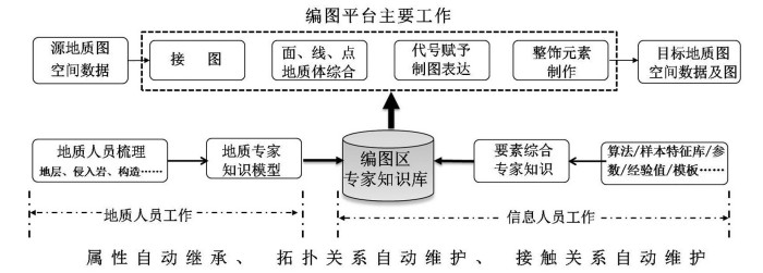
Figure 1.
Mode of geological compilation driven by database
-
Figure 2.
Samples of annotated styles
-
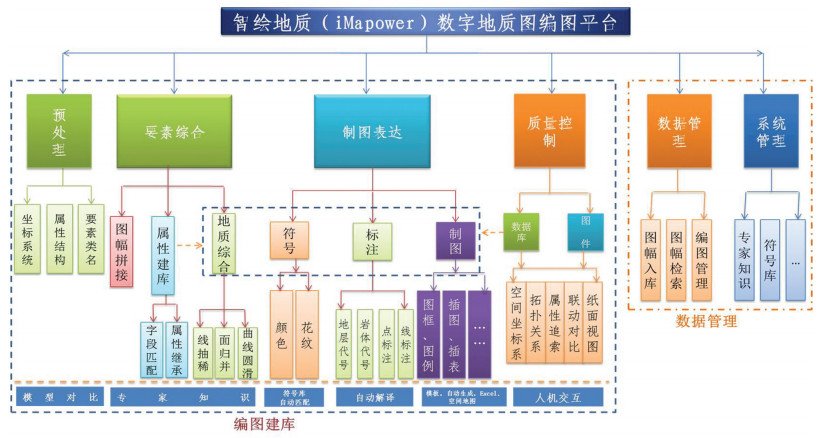
Figure 3.
General framework of iMapower function
-
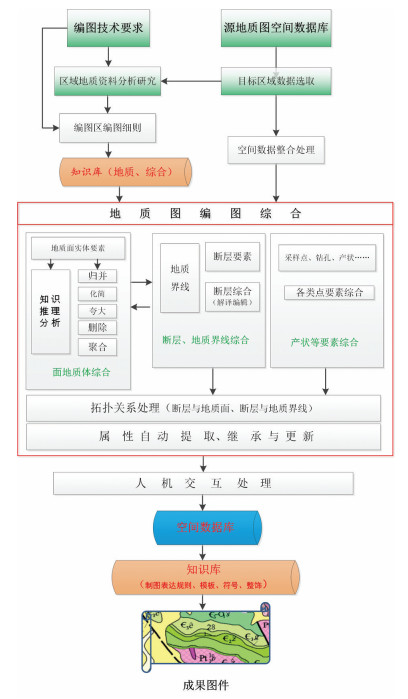
Figure 4.
Processing flow
-
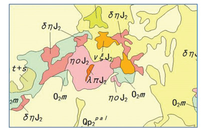
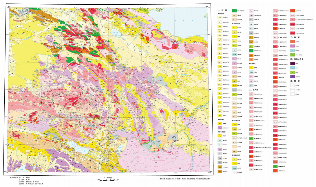
Figure 5.
Compiled geological map of Dulan-Xinghai area