
| Citation: |
LI Hongzhao, LIU Changli, LYU Dunyu, LIU Songbo, ZHANG Yun, ZHUO Zijun. Remote sensing & engineering geology survey technology for detection of occupied space by urban building foundation[J]. Geological Bulletin of China, 2021, 40(5): 798-806.

|
Remote sensing & engineering geology survey technology for detection of occupied space by urban building foundation
-
Abstract
The foundation of urban building occupies and uses numerous underground resources of space.Therefore, it is essential and significant to use the information of underground space resources' three-dimensional distribution for the urban underground space utilization planning.Nevertheless, the information in this respect is often scattered among various engineering construction institutions, which makes them uneasy to obtain.In order to tackle the problem hard to get the access of some information about underground space occupied by building foundation, it is necessary to explore an efficient and accurate technology for detection.By referring to the calculation method of the rock foundation, a method was developed and advanced to calculate the space occupied by building a foundation.High-resolution remote sensing information was adopted to obtain relevant parameters of ground buildings, collect engineering and geological survey data, and analyze the relevant data to acquire geotechnical parameters.By combining the parameters obtained by remote sensing detection and engineering survey with the calculation method of the space occupied by building foundation, a set of detection technique with the combination of remote sensing interpretation and geological engineering was formed and developed to measure the space occupied by building foundation.The application results in Zhengzhou Airport Area indicate that the technology is convenient to operate, efficient, effective, and accurate.It can completely fulfill the needs of underground space utilization planning with broad prospects for promotion and application.
-

-
References
[1] Admiraal H, Cornaro A. Why underground space should be included in urban planning policy-and how this will enhance an urban underground future[J]. Tunnelling and Underground Space Technology, 2016, 55: 214-220. doi: 10.1016/j.tust.2015.11.013 [2] Broere W. Urban underground space: solving the problems of today's cities[J]. Tunnelling&Underground Space Technology, 2016, 55: 245-248. [3] Nelson P P. A framework for the future of urban underground engineering[J]. Tunnelling and Underground Space Technology, 2015, 55: 32-39. [4] Bobylev N. Transitions to a High Density Urban Underground Space[J]. Procedia Engineering, 2016, 165: 184-192. doi: 10.1016/j.proeng.2016.11.750 [5] 钱七虎. 迎接我国城市地下空间开发高潮[J]. 岩土工程学报, 1998, (1): 112-113. doi: 10.3321/j.issn:1000-4548.1998.01.026 [6] 童林旭. 城市可持续发展的安全保障问题[J]. 城市发展研究, 1999, (6): 1-6. [7] 罗秀兰. 高层建筑之地下空间权利冲突探析[J]. 中国土地科学, 2015, 29(5): 70-76. [8] 王直民, 鲍海君, 黄莉. 城市地下空间开发利用中的桩基冲突及其规制[J]. 上海国土资源, 2018, 39(3): 73-77. doi: 10.3969/j.issn.2095-1329.2018.03.015 [9] 杨晓刚, 王睿, 黄伟亮. 基于国内典型城市对比的地下空间开发利用现状及问题分析[J]. 地学前缘, 2019, 137(3): 77-83. [10] 朱合华, 丁文其, 乔亚飞, 等. 简析我国城市地下空间开发利用的问题与挑战[J]. 地学前缘, 2019, 137(3): 30-39. [11] 周圆心, 何静, 徐旸. 基于遥感影像的城市地下空间资源量估算方法[J]. 城市地质, 2017, 12(3): 87-90. doi: 10.3969/j.issn.1007-1903.2017.03.017 [12] 何静, 郑桂森, 周圆心, 等. 城市地下空间资源探测方法研究及应用[J]. 地质通报, 2019, 38(9): 1571-1580. [13] 陈志龙, 刘宏. 城市地下空间总体规划[M]. 南京: 东南大学出版社, 2011: 37. [14] 贾宗团. 房屋建筑工程地基基础设计问题探析[J]. 工程建设与设计, 2016, (11): 16-18. doi: 10.3969/j.issn.1007-9467.2016.11.005 [15] 滕延京, 王卫东, 康景文, 等. 基础工程技术的新进展[J]. 土木工程学报, 2016, 49(4): 1-21. [16] GB/T 15968-2008, 遥感平面影像图制作规范[S]. 中国: 中国国家标准化管理委员会, 2008. [17] 田峰, 陈冬花, 黄新利, 等. 基于形态学阴影指数的高分二号影像建筑物高度估计[J]. 遥感技术与应用, 2017, 32(5): 844-850. [18] 李嘉良, 张超, 齐红甲. 遥感影像提取建筑物高度的方法[J]. 河北联合大学学报(自然科学版), 2013, (2): 127-131. [19] GB 50007-2011. 建筑地基基础设计规范[S]. 中国: 中华人民共和国住房和城乡建设部, 2012. [20] GB 50352-2019, 民用建筑设计统一标准[S]. 中国: 中华人民共和国住房和城乡建设部, 2019. [21] JGJ 79-2012, 建筑地基处理技术规范[S]. 中国: 中华人民共和国住房与城乡建设部, 2012. [22] 张俊红. 高层建筑岩土工程勘察工作量布置及评价若干问题探讨[C]//天津青年科技论坛. 天津市科协, 2012. [23] 陈建华. 浅谈建筑桩基岩土工程勘察工作布置[J]. 甘肃科技, 2011, 27(6): 123-124. doi: 10.3969/j.issn.1000-0952.2011.06.044 [24] 陈涛. 建筑结构荷载取值经验[EB/OL]. (2014). [2020-03-21]. https://wenku.baidu.com/view/1c55a4397fd5360cbb1adb39.html. -
Access History
Figures(3)
Tables(9)

Export File
Citation
LI Hongzhao, LIU Changli, LYU Dunyu, LIU Songbo, ZHANG Yun, ZHUO Zijun. Remote sensing & engineering geology survey technology for detection of occupied space by urban building foundation[J]. Geological Bulletin of China, 2021, 40(5): 798-806.
Format
Content
 DownLoad:
-
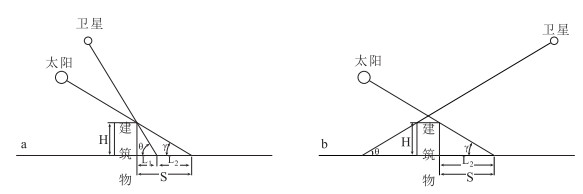
Figure 1.
Geometric relationship among sun, satellite, building and shadow
-
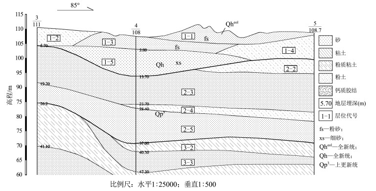
Figure 2.
Stratigraphic profile of the study area
-
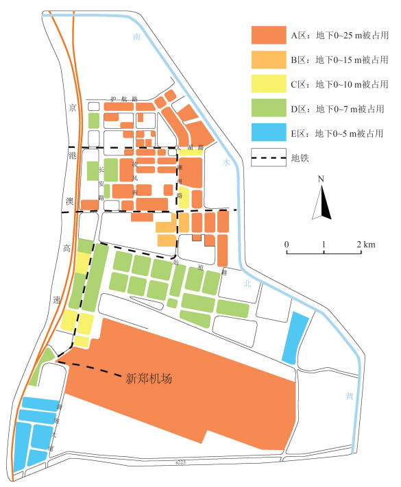
Figure 3.
Underground space distribution of building foundation in the Zhengzhou airport area