
| Citation: |
SHI Xu-fei, JIANG Shan, GUO Xiao-dong, ZHAO Hai-qing. VULNERABILITY ZONING OF MAIN GEOLOGICAL HAZARDS IN CHANGCHUN-JILIN-TUMEN ECONOMIC ZONE[J]. Geology and Resources, 2022, 31(5): 660-666. doi: 10.13686/j.cnki.dzyzy.2022.05.010

|
VULNERABILITY ZONING OF MAIN GEOLOGICAL HAZARDS IN CHANGCHUN-JILIN-TUMEN ECONOMIC ZONE
-
Abstract
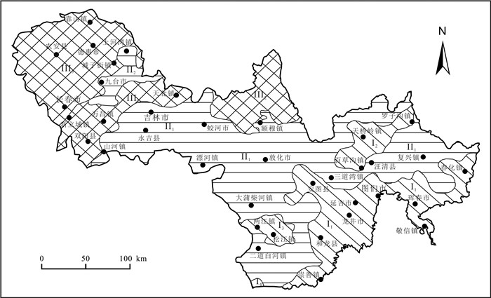
The synthetic risk index method is used for the vulnerability zoning of environmental geological hazards such as collapse, landslide and debris flow in Changchun-Jilin-Tumen Economic Zone. Precipitation is the most important factor inducing geohazards in the region, followed by topography and landform. Helong City, Longjing City, Yanji City, Hunchun City, part of Antu County, the upper reaches of Gaya River in Wangqing County and surrounding area of Tianchi Lake in Changbai Mountain are highly prone to the above geohazards, accounting for 22. 31% of the study area, with 726 geohazard sites and average density of 4. 52 sites per 100 km2; Low hilly areas such as Jiaohe City, Yongji County, Dunhua City and Wangqing County belong to medium susceptible area, accounting for about 48. 10% with 671 geohazard sites and average density of 1. 94 sites per 100 km2; Yitong County, Jilin City, Changchun City, Dehui County and Nong'an County are of low susceptible areas, accounting for about 29. 59% with 157 geohazard sites and average density of 0. 74 site per 100 km2.
-
Keywords:
- collapse /
- landslide /
- debris flow /
- vulnerability zoning /
- Changchun-Jili-Tumen Economic Zone /
- Jilin Province
-

-
References
[1] 袁家冬, 张娜. 东北老工业基地振兴与吉林省新型城市化的响应[J]. 世界地理研究, 2005, 14(2): 64-71. Yuan J D, Zhang N. Revitalization of the old industrial base of Northeast China and the response of new-type urbanization of Jilin Province[J]. World Regional Studies, 2005, 14(2): 64-71. [2] 王立春. 浅谈吉林省地质灾害现状[J]. 吉林地质, 2001, 20(2): 42-46. Wang L C. A preliminary study on the present situation of geologic hazard in Jilin Province[J]. Jilin Geology, 2001, 20(2): 42-46. [3] 滕继奎. 吉林省地质灾害类型及防治对策探讨[J]. 吉林地质, 1997, 16(2): 62-64. Teng J K. A preliminary study on geologic hazard types and the prevention in Jilin Province[J]. Jilin Geology, 1997, 16(2): 62-64. [4] 赵彦宁, 孙秀菲. 吉林省地质灾害发育特征及防治对策研究[J]. 吉林地质, 2012, 31(2): 117-122. Zhao Y N, Sun X F. Developmental features and control measures of geological disasters in Jilin Province[J]. Jilin Geology, 2012, 31(2): 117-122. [5] 张以晨. 吉林省地质灾害调查与区划综合研究及预报预警系统建设[D]. 长春: 吉林大学, 2012. Zhang Y C. Research on geological disaster survey and zoning in Jilin and forecasting and early warning system construction[D]. Changchun: Jilin University, 2012. [6] 赵海卿, 李广杰, 张哲寰. 吉林省东部山区地质灾害危害性评价[J]. 吉林大学学报(地球科学版), 2004, 34(1): 119-124. Zhao H Q, Li G J, Zhang Z H. Probability analysis of geological disaster in the mountainous area in East Jilin[J]. Journal of Jilin University (Earth Science Edition), 2004, 34(1): 119-124. [7] 张宁博. 基于GIS的岚皋县地质灾害易发性分区评价[D]. 西安: 长安大学, 2012. Zhang N B. The evaluating of the susceptibility about geological disaster in Langao County based on GIS[D]. Xi'an: Chang'an University, 2012. [8] Ohlmacher G C, Davis J C. Using multiple logistic regression and GIS technology to predict landslide hazard in northeast Kansas, USA[J]. Engineering Geology, 2003, 69(3/4): 331-343. [9] 鲁光银, 韩旭里, 朱自强, 等. 地质灾害综合评估与区划模型[J]. 中南大学学报(自然科学版), 2005, 36(5): 877-881. Lu G Y, Han X L, Zhu Z Q, et al. Synthetical evaluation and classification model of geological hazards[J]. Journal of Central South University (Science and Technology), 2005, 36(5): 877-881. [10] 唐伟. GIS系统在区域地质环境质量评价中的应用[D]. 西安: 长安大学, 2006. Tang W. Application of GIS system in regional geological environment quality evaluation[D]. Xi'an: Chang'an University, 2006. (in Chinese) [11] 张丽, 李广杰, 周志广, 等. 基于灰色聚类的区域地质灾害危险性分区评价[J]. 自然灾害学报, 2009, 18(1): 164-168. Zhang L, Li G J, Zhou Z G, et al. Grey clustering method-based zoning assessment of regional geological disaster[J]. Journal of Natural Disasters, 2009, 18(1): 164-168. [12] Lee S, Min K. Statistical analysis of landslide susceptibility at Yongin, Korea[J]. Environmental Geology, 2001, 40(9): 1095-1113. [13] 单新建, 叶洪, 李焯芬, 等. 基于GIS的区域滑坡危险性预测方法与初步应用[J]. 岩石力学与工程学报, 2002, 21(10): 1507-1514. Shan X J, Ye H, Lee C F, et al. Prediction method of dangerous areas of regional landslide based on GIS and its application[J]. Chinese Journal of Rock Mechanics and Engineering, 2002, 21(10): 1507-1514. [14] 于明宽. 模糊综合评判法在靖宇县地质灾害易发区划分中的应用[D]. 长春: 吉林大学, 2006. Yu M K. Application to the fuzzy comprehensive evaluation in the zoning of the geological hazard in the Jingyu County[D]. Changchun: Jilin University, 2006. [15] 褚洪斌, 母海东, 王金哲. 层次分析法在太行山区地质灾害危险性分区中的应用[J]. 中国地质灾害与防治学报, 2003, 14(3): 125-129. Chu H B, Mu H D, Wang J Z. Application of analytic hierarchy process on zoning hazard degree of geologic disaster in Taihang Mountain region[J]. The Chinese Journal of Geological Hazard and Control, 2003, 14(3): 125-129. [16] Ercanoglu M, Gokceoglu C. Assessment of landslide susceptibility for a landslide-prone area (North of Yenice, NW Turkey) by fuzzy approach[J]. Environmental Geology, 2002, 41(6): 720-730. [17] Collison A J C, Anderson M G. Using a combined slope hydrology/ stability model to identify suitable conditions for landslide prevention by vegetation in the humid tropics[J]. Earth Surface Processes and Landforms, 1996, 21(8): 737-747. [18] 孟凡奇, 李广杰, 秦胜伍, 等. 基于证据权法的泥石流危险度区划[J]. 吉林大学学报(地球科学版), 2010, 40(6): 1380-1384. Meng F Q, Li G J, Qin S W, et al. Zoning of debris flow hazard degree with weight-of-evidence method[J]. Journal of Jilin University (Earth Science Edition), 2010, 40(6): 1380-1384. [19] 阮沈勇, 黄润秋. 基于GIS的信息量法模型在地质灾害危险性区划中的应用[J]. 成都理工学院学报, 2001, 18(1): 89-92. Ruan S Y, Huang R Q. Application of GIS-based information model on assessment of geological hazards risk[J]. Journal of Chengdu University of Technology, 2001, 18(1): 89-92. [20] 傅卫东. 地质灾害易发性区划研究与防治对策——以南靖县为例[D]. 武汉: 中国地质大学, 2005. Fu W D. Lability zoning study and countermeasure of geological hazard: Taking Nanjing as an example[D]. Wuhan: China University of Geosciences, 2005. [21] 徐开祥, 黄学斌, 付小林, 等. 地质灾害治理工程的特殊性风险性及治理工程风险事件实例分析[J]. 中国地质灾害与防治学报, 2006, 17(3): 127-132. Xu K X, Huang X B, Fu X L, et al. Uniqueness and risk of geological hazard remediation and some typical cases[J]. The Chinese Journal of Geological Hazard and Control, 2006, 17(3): 127-132. [22] 国土资源部. 《县(市)地质灾害调查与区划基本要求》实施细则[S]. 北京: 国土资源部, 2006. Ministry of Land and Resources of the People's Republic of China. Detailed rules for the Implementation of Basic Requirements for County and City Geological Hazard Investigation and Zoning[S]. Beijing: Ministry of Land and Resources of the People's Republic of China, 2006. (in Chinese) -
Access History
Figures(2)

Export File
Citation
SHI Xu-fei, JIANG Shan, GUO Xiao-dong, ZHAO Hai-qing. VULNERABILITY ZONING OF MAIN GEOLOGICAL HAZARDS IN CHANGCHUN-JILIN-TUMEN ECONOMIC ZONE[J]. Geology and Resources, 2022, 31(5): 660-666. doi: 10.13686/j.cnki.dzyzy.2022.05.010
Format
Content
 DownLoad:
-
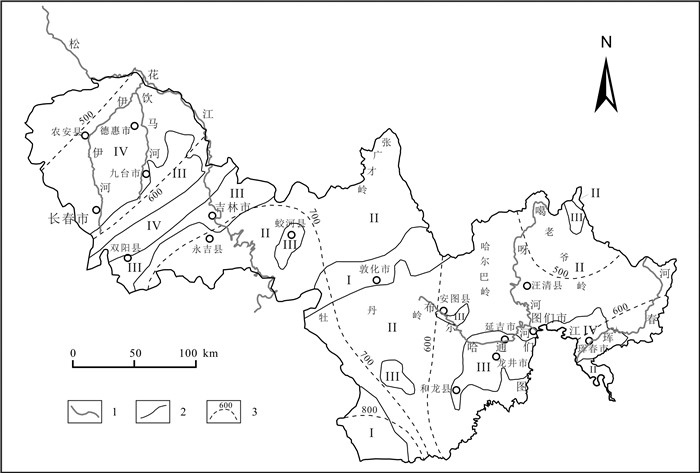
Figure 1.
Geomorphic division and multiyear average precipitation isoline in the CJT Economic Zone
-
Figure 2.
Environmental geological zoning map of the CJT Economic Zone