
| Citation: |
GUO Chang-lai, CUI Jian, SUN Xiu-bo, MA Yu-xiang, AI Cong-fang. NUMERICAL SIMULATION ANALYSIS OF HYDRODYNAMIC FORCE IN DALINGHE RIVER ESTUARY[J]. Geology and Resources, 2022, 31(5): 667-674. doi: 10.13686/j.cnki.dzyzy.2022.05.011

|
NUMERICAL SIMULATION ANALYSIS OF HYDRODYNAMIC FORCE IN DALINGHE RIVER ESTUARY
-
Abstract
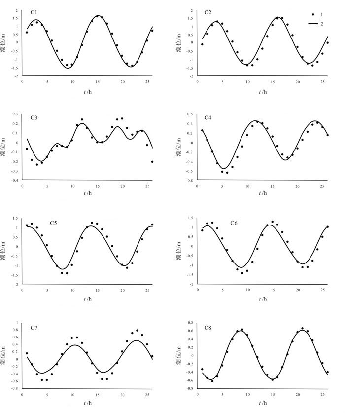
Based on the long series of measured data about Dalinghe River runoff and underwater terrain, the hydrodynamic numerical model is established to simulate the tidal current of Dalinghe River estuary and the main characteristics of hydrodynamic process in the estuary and northern sea area of Liaodong Bay are discussed considering the influence of tidal current and river runoff. The results show that the ocean current in waters around the estuary is mainly tidal current with obvious reciprocating nature. The general movement trend of tidal current is northeastward at high tide and southwestward at low tide. The speed of spring tide is larger than that of neap tide and the duration of flood current is almost equal to that of ebb current, with the maximum flood speed of 0.52 m/s and maximum ebb speed of 0.4 m/s. The distribution of average tidal current intensity during flood and ebb is roughly consistent with the sea depth contour.
-
Keywords:
- hydrodynamic force /
- numerical simulation /
- tidal current /
- Dalinghe River /
- Liaodong Bay
-

-
References
[1] 王佳琦, 贾燕锋. 近60年大凌河中上游水沙变化特征[J]. 水土保持研究, 2018, 25(3): 35-40. Wang J Q, Jia Y F. Variation of runoff and sediment in the middle and upper reaches of Daling River during the past 60 years[J]. Research of Soil and Water Conservation, 2018, 25(3): 35-40. [2] 成遣, 周林飞, 谭艳芳. 辽宁省凌河口湿地生态服务效应货币价值评估[J]. 人民黄河, 2012, 34(7): 64-67. Cheng Q, Zhou L F, Tan Y F. Evaluation of monetary value for ecosystem service function of Linghe River estuarine wetland[J]. Yellow River, 2012, 34(7): 64-67. [3] 张娜. 基于SWAT模型的大凌河流域径流演变规律分析[J]. 黑龙江水利科技, 2020, 48(1): 7-10. Zhang N. Analysis of runoff evolution law in Daling River Basin based on SWAT model[J]. Heilongjiang Science and Technology of Water Conservancy, 2020, 48(1): 7-10. [4] 赵垠. 大凌河湿地生态环境现状及保护对策[J]. 黑龙江水利科技, 2017, 45(3): 183-185. Zhao Y. Ecological environment and protection strategy of Daling River wetland[J]. Heilongjiang Science and Technology of Water Conservancy, 2017, 45(3): 183-185. (in Chinese) [5] Belde J, Reuning L, Back S. Bottom currents and sediment waves on a shallow carbonate shelf, Northern Carnarvon Basin, Australia[J]. Continental Shelf Research, 2017, 138: 142-153. doi: 10.1016/j.csr.2017.03.007 [6] 周跃华, 岳志春, 潘汀超, 等. 基于GIS与水动力模型的陶乐防洪保护区漫溢洪水风险分析[J]. 水力发电, 2020, 46(10): 22-27. doi: 10.3969/j.issn.0559-9342.2020.10.006 Zhou Y H, Yue Z C, Pan T C, et al. Risk analysis of overflow flood in Taole flood protection area based on GIS and hydrodynamic model [J]. Water Power, 2020, 46(10): 22-27. doi: 10.3969/j.issn.0559-9342.2020.10.006 [7] 孙玲玲. 基于MIKE21的水库洪水期洪水演进数值模拟[J]. 工程技术研究, 2020, 5(11): 246-248. Sun L L. Numerical simulation of flood evolution in reservoir flood period based on MIKE 21[J]. Engineering and Technological Research, 2020, 5(11): 246-248. [8] 锁晓南, 李春光, 尚彦祥, 等. 基于MIKE21模型的黄河四排口河段洪水演进数值模拟[J]. 科技视界, 2021(4): 104-107. Suo X N, Li C G, Shang Y X, et al. Numerical simulation of flood evolution in the Fourth Outlet reach of the Yellow River based on MIKE 21 model[J]. Science & Technology Vision, 2021(4): 104- 107. (in Chinese) [9] Ferziger J H, Peric M. Computational methods for fluid dynamics [M]. 2nd ed. Berlin: Springer, 1999. [10] DHI Water & Environment. MIKE 21 & MIKE 3 flow model FM hydrodynamic and transport module scientific documentation[M]. Hrsholm, Denmark: DHI Water & Environment, 2017. [11] Lin G F, Lai J S, Guo W D. Finite-volume component-wise TVD schemes for 2D shallow water equations[J]. Advances in Water Resources, 2003, 26(8): 861-873. [12] Abbott M B, Ionescu F. On the numerical computation of nearly horizontal flows[J]. Journal of Hydraulic Research, 1967, 5(2): 97- 117. [13] 周哲睿, 刘姣, 吴浩力, 等. 基于MIKE21模型的水交换数值模拟研究[J]. 陕西水利, 2021, 17(4): 17-20. Zhou Z R, Liu J, Wu H L, et al. Numerical simulation of water exchange based on MIKE 21 model[J]. Shaanxi Water Resources, 2021, 17(4): 17-20. (in Chinese) [14] 秦成栋, 钱鞠, 李明都, 等. 基于MIKE21模型的宋家湾水库水环境影响数值模拟[J]. 甘肃水利水电技术, 2021, 57(2): 1-10, 19. Qin C D, Qian J, Li M D, et al. Numerical simulation of water environmental impact of Songjiawan Reservoir based on MIKE 21 model[J]. Gansu Water Resources and Hydropower Technology, 2021, 57(2): 1-10, 19. (in Chinese) [15] Wang Q, Guo X Y, Takeoka H. Seasonal variations of the Yellow River plume in the Bohai Sea: A model study[J]. Journal of Geophysical Research, 2008, 113(C8): C08046. [16] 袁本坤, 黄蕊, 商杰, 等. 基于岸基观测数据的渤海沿岸海域表层温盐特征分析[J]. 海洋开发与管理, 2015, 32(12): 31-34. Yuan B K, Huang R, Shang J, et al. Analysis of surface thermohaline characteristics in Bohai Sea based on shore-based observation data[J]. Ocean Development and Management, 2015, 32(12): 31-34. (in Chinese) [17] 朱亮, 刘景涛, 杨明楠, 等. 1998年以来兰州市地下水环境变化及驱动因素[J]. 中国地质, 2020, 47(6): 1677-1687. Zhu L, Liu J T, Yang M N, et al. Changes and driving factors of groundwater environment in Lanzhou since 1998[J]. Geology in China, 2020, 47(6): 1677-1687. [18] 宫兴梅. 辽宁省铁甲水库入库口水动力场特征数值模拟研究[J]. 中国水能及电气化, 2020(12): 18-20, 17. Gong X M. Numerical simulation study of inlet hydrodynamic field characteristics of Tiejia Reservoir in Liaoning Province[J]. China Water Power & Electrification, 2020(12): 18-20, 17. [19] 王俊珲, 侯精明, 王峰, 等. 洪涝过程模拟及三维实景展示方法研究[J]. 自然灾害学报, 2020, 29(4): 149-160. Wang J H, Hou J M, Wang F, et al. Study on flood process simulation and 3D scene display method[J]. Journal of Natural Disasters, 2020, 29(4): 149-160. [20] 王晓文. 水质数值模型在浑河流域水量水质模拟中的应用[J]. 地下水, 2021, 43(1): 69-72. Wang X W. Application of water quality numerical model in simulation of water quantity and quality in Hunhe River Basin[J]. Ground Water, 2021, 43(1): 69-72. (in Chinese) -
Access History
Figures(6)
Tables(1)

Export File
Citation
GUO Chang-lai, CUI Jian, SUN Xiu-bo, MA Yu-xiang, AI Cong-fang. NUMERICAL SIMULATION ANALYSIS OF HYDRODYNAMIC FORCE IN DALINGHE RIVER ESTUARY[J]. Geology and Resources, 2022, 31(5): 667-674. doi: 10.13686/j.cnki.dzyzy.2022.05.011
Format
Content
 DownLoad:

-
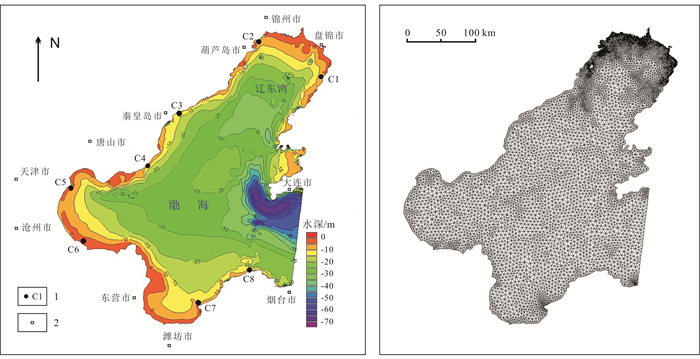
Figure 1.
Terrain distribution, station location and grid division in large-sized model calculation domain
-
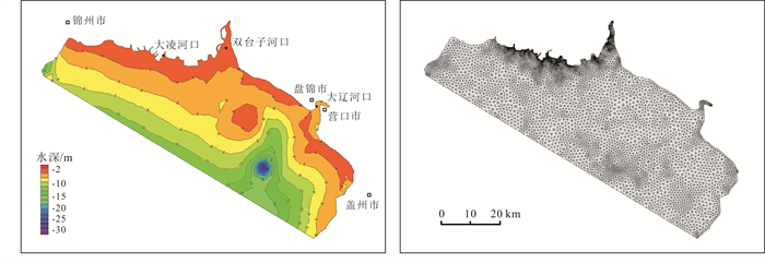
Figure 2.
Terrain distribution and grid division in small-sized model calculation domain
-
Figure 3.
Comparison of tide levels at representative stations around Bohai Sea
-
Figure 4.
Flow field states at different times
-
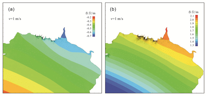
Figure 5.
Distribution of flow fields in northern Liaodong Bay
-
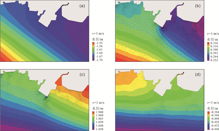
Figure 6.
Flow field distribution at different times in the sea area of Dalinghe River estuary