

| Citation: |
HUANG Qin-Yi, LI Qing-Lan, LIU Lu. 2024. The Study on Vertical Structure Characteristics of Ground Substrate in Nan’ao Street, Shenzhen. South China Geology, 40(4): 783-793. doi: 10.3969/j.issn.2097-0013.2024.04.016

|
The Study on Vertical Structure Characteristics of Ground Substrate in Nan’ao Street, Shenzhen
-
Abstract
Ground substrate survey can provide a scientific basis for the local economic sustainable development, rational resource utilization, and ecological environment protection. This study focused on the Nan'ao Street in Shenzhen as the study region, conducting a zonal survey based on rock weathering degree and vegetation coverage. The primary objectives were to investigate the vertical structure characteristics of ground substrate in low mountain and hilly areas, as well as in coastal Quaternary sedimentary areas, and to explore suitable methods for the ground substrate survey in Shenzhen. The following two understandings are obtained: (1) By selecting sampling points and measuring exposed profiles, we determined that the vertical structure of the ground substrate in the weathered crust area of low mountain and hills is mainly characterized by bedrock covered with a thin weathering crust, with the topsoil primarily consisting of loam within a thickness of 1 meter and the underlying bedrock primarily consisting of magmatic rocks. (2) By organizing existing drilling data, we ascertained that the vertical structure of the ground substrate in the coastal Quaternary sedimentary area is mainly characterized by bedrock covered with clay, and bedrock covered with sandy soil and clay, with some areas covered by artificial fill. The thickness of the soil layer is mostly within 20 meters. This study fills a gap in the field of ground substrate survey in Shenzhen, providing a foundation for understanding the interrelationships between ground substrate and other natural resources and environmental factors, and offers reference technical methods and suggestions for the follow-up ground substrate surveys in Shenzhen.
-

-
References
[1] 陈 彭,侯红星,马骏驰,鲁 敏,秦 天.2023.低山丘陵区黑土地地表基质调查研究思路——以扎兰屯地区为例[J]. 中国国土资源经济,36(2):81-89. [2] 陈 彭,侯红星,马骏驰,孙 浩,荆 元.2024.地表基质分类标准与编图方法探索——以内蒙古雅鲁河流域为例[J]. 中国地质调查,11(2):51-61. [3] 董天钰,刘晓煌,常 铭,邢莉圆,王 然.2023.浅析地表基质的本质内涵及研究方向[J]. 西北地质,56(4):213-217. doi: 10.12401/j.nwg.2023040 [4] 高 奇,李新斌,刘瀚元.2024.综合物探在陕西韩城地表基质调查中的应用[J]. 地理科学研究,13(2):348-354. [5] 葛良胜,侯红星,夏 锐.2022.自然资源地表基质调查技术体系构建[J]. 地理信息世界,29(5):20-27. doi: 10.3969/j.issn.1672-1586.2022.05.005 [6] 葛良胜,夏 锐.2023.高标准农田建设:基于地表基质调查的解决方案[J]. 中国国土资源经济,36(5):4-13. [7] 葛良胜,杨贵才.2020.自然资源调查监测工作新领域:地表基质调查[J]. 中国国土资源经济,33(9):4-11+67. [8] 郝爱兵,殷志强,李洪宇,鲁青原,彭 令,邵 海,江奇达,赵晓峰,刘玖芬,庞菊梅,杨 柯,陈 彭,孔繁鹏,侯红星,鲁 敏. 2024. 地表基质的科学内涵与理论框架[J/OL]. 地质学报. https://doi.org/10.19762/j.cnki.dizhixuebao.2024439. [9] 侯红星,葛良胜,孙 肖,孔祥斌,卢卫华,秦 天,孔繁鹏,杨华本,杨 柯.2022.地表基质在中国黑土地资源调查评价中的应用探讨——基于黑龙江宝清地区地表基质调查[J]. 自然资源学报,37(9):2264-2276. [10] 侯红星,葛良胜,孙 肖,卢卫华,鲁 敏,秦 天,杨华本,杨 柯,孔繁鹏.2021a.地表基质调查内容及要素-属性指标体系探讨[J]. 自然科学,9(4):433-442. [11] 侯红星,张蜀冀,鲁 敏,张中跃,孙 肖,秦 天,王 献,张金龙,邵兴坤,王 伟.2021b.自然资源地表基质层调查技术方法新经验——以保定地区地表基质层调查为例[J]. 西北地质,54(3):277-288. [12] 霍 东,陈占生,艾晓军,汪敏骅,于小健,王 乔.2024.地表基质调查对黑土地保护技术支撑的思考——以台安县为例[J]. 农业与技术,44(15):56-61. [13] 贾 磊,刘 洪,欧阳渊,张 伟,窦 磊,刘子宁,莫 滨,陈 恩,张腾蛟.2022.基于地质建造的南方山地-丘陵区地表基质填图单元划分方案——以珠三角新会—台山地区为例[J]. 西北地质,55(4):140-157. [14] 李洪宇,刘晓煌,刘玖芬,赵晓峰,张文博,李福杰.2024.基于地貌区划的新疆地表基质质地分类方案[J]. 现代地质,38(3):706-717. [15] 刘玖芬,赵晓峰,侯红星,秦 天,陈占生,徐立明,杨 柯,孔繁鹏,刘晓煌,卢 兵,李子奇,刘 佳,包茹意,郝爱兵.2024.地表基质调查分层及分层测试指标体系设计与构建[J]. 岩矿测试,43(1):16-29. [16] 梅 村,康镇江,唐跃林,张 崧,管福贞,龚淑云,李 甘.2011a.基于新测年资料的蓟县运动和燕山早期运动表现探讨:以深圳西部地区及东部大鹏半岛国家地质公园地区为例[J]. 地学前缘,18(3):179-188. [17] 梅 村,唐跃林,张 崧,康镇江,管福贞,龚淑云,李 甘.2011b.深圳大鹏半岛国家地质公园中生代火山地层的时代讨论[J]. 地层学杂志,35(4):454-462. [18] 邵 海,王英男,殷志强,邢 博,金爱芳,庞菊梅,王瑞丰.2023.承德坝上高原如意河流域地表基质调查与编图探索[J]. 水文地质工程地质,50(2):150-159. [19] 王建伟,宋立东,佟智强,刘 浩,杨洪祥,高 博.2024.基于地貌单元分区的地表基质结构调查方法与实践——以长春地区为例[J]. 地质与资源,33(3):355-364. [20] 杨 永,李瑞红,赵凯明,刘 航,李明军,王学文.2024.大兴安岭东麓黑土地地表基质空间分布特征及其生态效应[J]. 地质论评,70(S1):307-308. [21] 姚锦梅,李洁兰,康镇江,宋建潮,唐嘉锋.2022.深圳大鹏半岛火山和香港火山活动特征对比研究[J]. 地质与勘探,58(1):148-157. doi: 10.12134/j.dzykt.2022.01.014 [22] 姚晓峰,杨建锋,左力艳,张婷婷,陈 骥,张翠光.2022.地表基质的内涵辨析与调查思路[J]. 地质通报,41(12):2097-2105. doi: 10.12097/j.issn.1671-2552.2022.12.002 [23] 殷志强,陈自然,李 霞,卫晓锋,邵 海.2023.地表基质综合调查:内涵、分层、填图与支撑目标[J]. 水文地质工程地质,50(1):144-151. [24] 殷志强,秦小光,张蜀冀,卫晓锋,侯红星,何泽新,鲁 敏.2020.地表基质分类及调查初步研究[J]. 水文地质工程地质,47(6):8-14. [25] 袁国礼,侯红星,刘建宇,王 泉,郭晓宇,贾颜卉.2023.服务生态文明的生态地质调查工作方法浅析——以地表基质调查为例[J]. 西北地质,56(3):30-38. doi: 10.12401/j.nwg.2023065 [26] 张 闯,王 苒,尚晓雨,杨 阳,陈 龙,董 硕,刘 泽,杨 科.2023.水域地表基质调查方法探索——以衡水湖为例[J]. 国土资源导刊,20(2):109-113. doi: 10.3969/j.issn.1672-5603.2023.02.016 [27] 张凤荣.2023.论地表基质层重点调查内容和优先调查区域[J]. 中国土地,(2):40-41. [28] 朱晛亭,罗 红,李 煜,徐 聪,李 朋,翁茂芝,周 峰. 2023. 地表基质质量综合评价探索:以武汉市长江新城为例[J]. 资源环境与工程,37(4):412-419. [29] 自然资源部. 2020a. 自然资源部关于印发《自然资源调查监测体系构建总体方案》的通知[Z]. http://gi.mnr.gov.cn/202001/t20200117_2498071.html. [30] 自然资源部. 2020b. 自然资源部办公厅印发《地表基质分类方案(试行)》的通知[Z]. http://gi.mnr.gov.cn/202012/t20201222_2596025.html. [31] Anderson S P, Bales R C, Duffy C J. 2008. Critical zone observatories: building a network to advance interdisciplinary study of earth surface processes[J]. Mineralogical Magazine, 72(1): 7-10. doi: 10.1180/minmag.2008.072.1.7 [32] Lin H S. 2010. Earth's critical zone and hydropedology: concepts, characteristics, and advances[J]. Hydrology and Earth System Sciences, 14(111): 25-45. -
Access History

Figures(5)
Tables(2)

Export File
Citation
HUANG Qin-Yi, LI Qing-Lan, LIU Lu. 2024. The Study on Vertical Structure Characteristics of Ground Substrate in Nan’ao Street, Shenzhen. South China Geology, 40(4): 783-793. doi: 10.3969/j.issn.2097-0013.2024.04.016
Format
Content
 DownLoad:

-
Figure 1.
Reginal geological map of Nan’ao Street, Shenzhen City
-
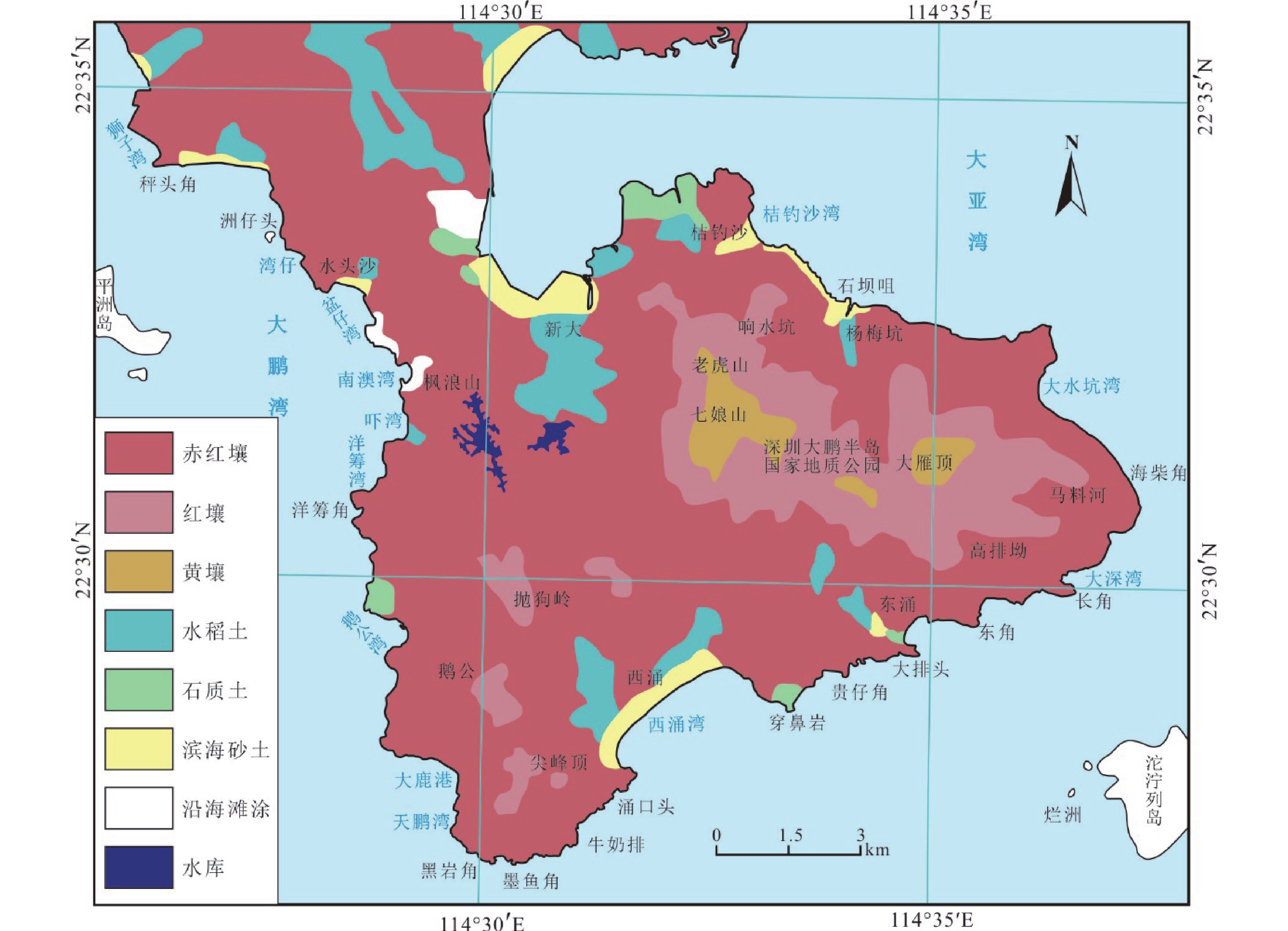
Figure 2.
Spatial distribution map of soil types of Nan’ao Street, Shenzhen City
-
Figure 3.
Main regional division of the study area based on the geological and topographic conditions
-
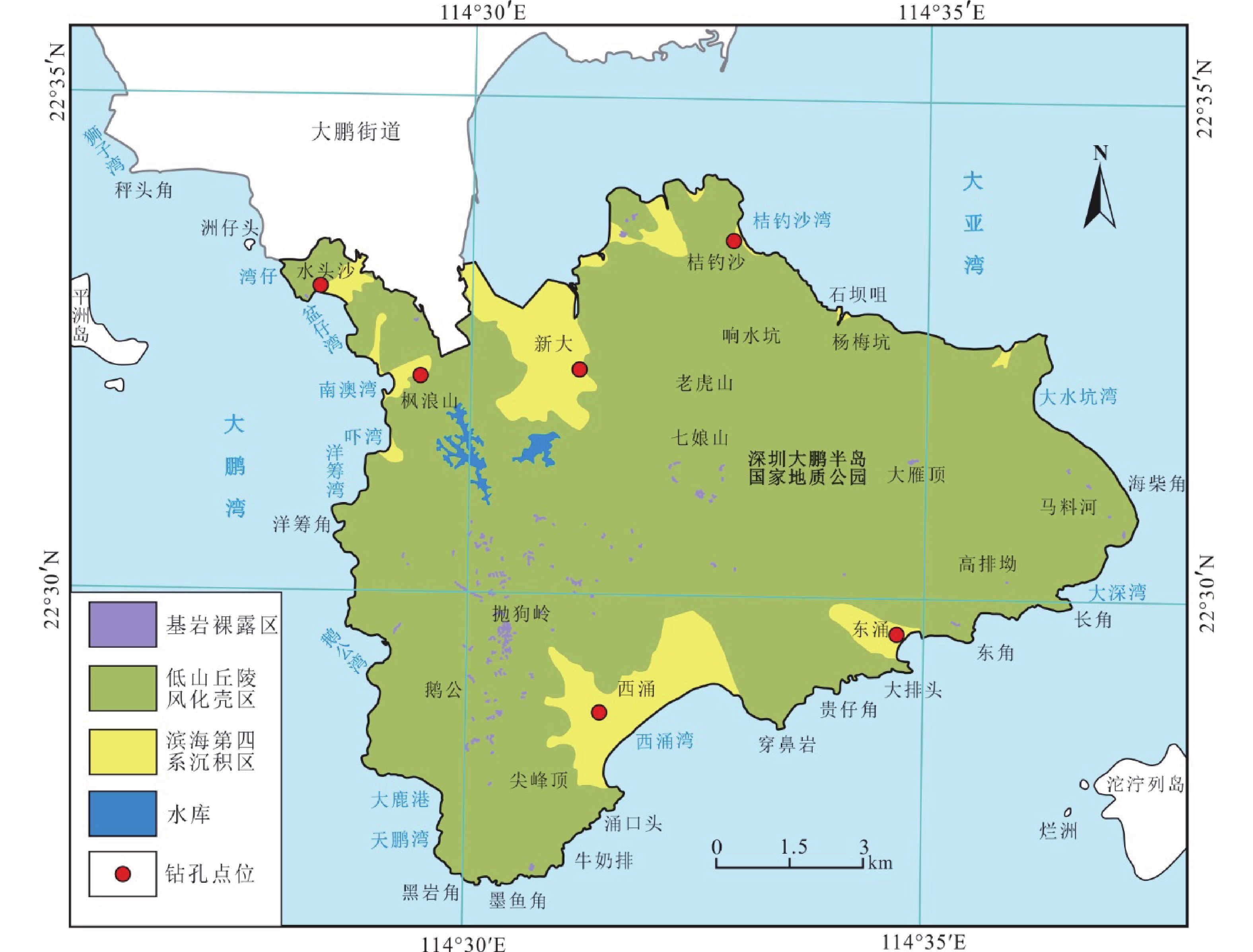
Figure 4.
Distribution map of land use types (a) and the ground substrate profile in regolith of low mountains and hills (b) of the study area
-
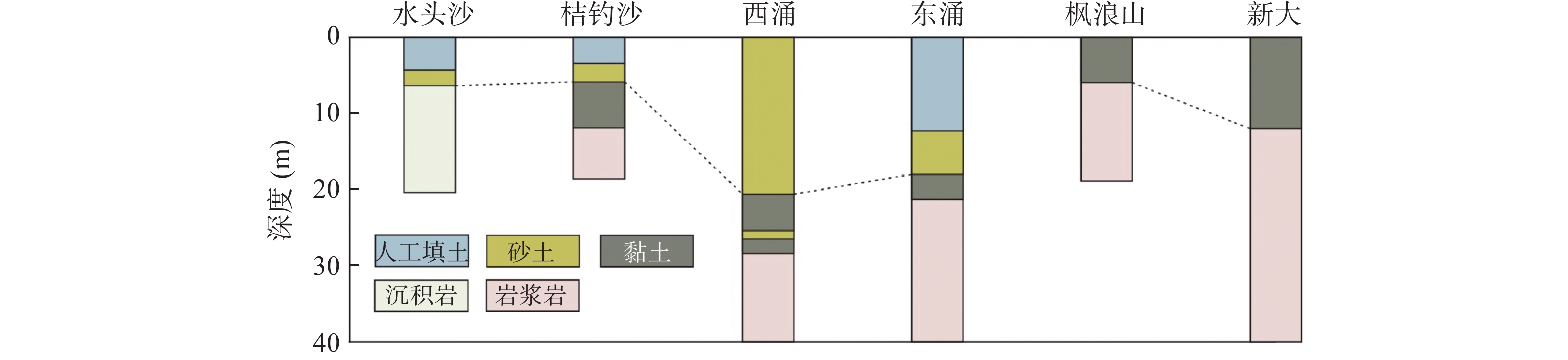
Figure 5.
Ground substrate vertical profile of the quaternary sedimentary boreholes in the study area