

| Citation: |
QIU Jia-Rong, HUANG Li-Bing, WANG Jin-Qiu. 2024. Hazard Assessment of Collapse and Landslide Disasters in the Upper Reaches of the Dongjiang River Under Different Rainfall Conditions: A Case Study of Sidu Town, Longchuan County, Guangdong Province. South China Geology, 40(4): 773-782. doi: 10.3969/j.issn.2097-0013.2024.04.015

|
Hazard Assessment of Collapse and Landslide Disasters in the Upper Reaches of the Dongjiang River Under Different Rainfall Conditions: A Case Study of Sidu Town, Longchuan County, Guangdong Province
-
Abstract
It is an urgent need to carry out systematic, detailed, and refined susceptibility assessments in high-risk areas prone to landslides and geological disasters, as well as to conduct risk investigations under different rainfall conditions, to protect the lives and property of local people effectively. This paper takes Sidu Town, Longchuan County, Guangdong Province, as the study area, and utilizes remote sensing images, ground surveys, and regional geological and environmental data to establish a system of landslide disaster susceptibility evaluation indexes by selecting eight influencing factors such as slope gradient, elevation difference, slope shape, cover layer thickness, geotechnical body type, distance from geological structures, vegetation cover index, and land-use types, and applying the informativeness method to assess the susceptibility of Sidu Town to landslide disasters. On this basis, the hazard index method was used to discuss the risk of landslide disaster in Sidu Town under the two working conditions of 24-hour cumulative rainfall of 100 mm rainfall and 24-hour cumulative rainfall of 250 mm rainfall. The result reveals that: (1) The susceptibility of landslide disasters in Sidu Town is predominantly low, covering 65.87% of the total study area, yet 86.23% of landslide disasters are concentrated in the medium susceptibility zone; (2) Under the 24-hour cumulative rainfall of 100 mm scenario, the risk of landslide disasters in Sidu Town is primarily moderate, accounting for 67.86% with an area of 52.71 km2; under the 24-hour cumulative rainfall of 250 mm scenario, the risk of landslide disasters in Sidu Town is primarily high, accounting for 67.51% with an area of 52.44 km2. The evaluation system used in this study is deemed highly applicable for assessing the susceptibility to geological disasters in Sidu Town. The evaluation results, validated through field checks, are considered useful and therefore provide a foundation for further geological disaster prevention and control strategies within the region.
-

-
References
[1] 陈 律.2020.遥感技术广东龙川县地质灾害调查的应用[J]. 甘肃科技,36(20):65-67. doi: 10.3969/j.issn.1000-0952.2020.20.022 [2] 冯 卫,唐亚明,马红利,徐 永.2021.一种基于斜坡单元的山区城镇地质灾害高危险坡段识别方法[J]. 灾害学,36(1):64-68. doi: 10.3969/j.issn.1000-811X.2021.01.013 [3] 广东省地质矿产局. 1988. 广东省区域地质志[M]. 北京:地质出版社. [4] 郭子正,殷坤龙,黄发明,付 圣,张 文.2019.基于滑坡分类和加权频率比模型的滑坡易发性评价[J]. 岩石力学与工程学报,38(2):287-300. [5] 姬永涛,王 鲜,郝 业,王 鑫,韩秀清,乔丁丁.2022.基于斜坡单元的陕西省城镇地质灾害风险调查评价——以西安市蒋村街道为例[J]. 灾害学,37(4):211-219. doi: 10.3969/j.issn.1000-811X.2022.04.032 [6] 李彧磊,熊启华,龙 婧,王芮琼,陈标典,曾 嘉.2023.基于斜坡单元鄂西山区典型集镇地质灾害风险评价[J]. 科学技术与工程,23(6):2326-2338. doi: 10.12404/j.issn.1671-1815.2023.23.06.02326 [7] 刘 帅,朱杰勇,杨得虎,马 博.2024.不同降雨工况条件下的崩滑地质灾害危险性评价[J]. 地质科技通报,43(2):253-267. [8] 祁生文,许 强,刘春玲,张 兵,梁 宁,童立强.2009.汶川地震极重灾区地质背景及次生斜坡灾害空间发育规律[J]. 工程地质学报,17(1):39-49. doi: 10.3969/j.issn.1004-9665.2009.01.005 [9] 王灿星,朱杰勇,喻聪骏,刘家恺,祝传兵. 2024.基于皮尔逊Ⅲ型曲线的不同降雨工况下的崩滑地质灾害危险性评价[J/OL]. 地质科技通报. https://doi.org/10.19509/j.cnki.dzkq.tb20230472. [10] 王佳佳,殷坤龙,肖莉丽.2014.基于GIS和信息量的滑坡灾害易发性评价-以三峡库区万州区为例[J]. 岩石力学与工程学报,33(4):797-808. [11] 王天河,赖桂林,李 坤,崔金凤,钟天辅.2024.月度防控视角下韩江下游城镇地质灾害危险性评价[J]. 人民长江,55(7):98-107+137. [12] 伍红雨,吴 遥,郑 璟.2024.2022年华南极端“龙舟水”与大气环流及海温异常的关系[J]. 大气科学学报,47(3):450-459. [13] 许 泰,鄂崇毅,蒋兴波,朱秀兰,李彦举,张 卓,张兆康,曾泳昕.2021.永登县苦水镇潜在地质灾害时空分布特征及易发性与危险性分区评价[J]. 科学技术与工程,21(33):14081-14092. doi: 10.3969/j.issn.1671-1815.2021.33.007 [14] 严 明,谢婉丽,何亚南,刘琦琦,何高锐,杨 惠.2023.基于极值降雨假设法的城镇地质灾害风险性评价耦合模型研究——以安康市岚皋县官元镇为例[J]. 灾害学,38(4):219-227. doi: 10.3969/j.issn.1000-811X.2023.04.034 [15] 张 伟.2017.浅析广东省崩滑流地质灾害与地层岩性关系[J]. 西部资源,(4):104-105. doi: 10.3969/j.issn.1672-562X.2017.04.043 [16] 张学乐,杨礼聪.2023.龙川县地质灾害风险调查及成因影响分析研究[J]. 云南水力发电,39(8):331-335. doi: 10.3969/j.issn.1006-3951.2023.08.079 [17] 张永双,王冬兵,李 雪,吴瑞安,唐 渊,任三绍,李金秋,罗 亮.2024.青藏高原构造混杂岩带的孕灾地质基因与重大工程地质问题研究[J]. 地质学报,98(3):992-1005. [18] 周 超,常 鸣,徐 璐,车宏晓.2020.贵州省典型城镇矿山地质灾害风险评价[J]. 武汉大学学报(信息科学版),45(11):1782-1791. -
Access History
Figures(5)
Tables(5)

Export File
Citation
QIU Jia-Rong, HUANG Li-Bing, WANG Jin-Qiu. 2024. Hazard Assessment of Collapse and Landslide Disasters in the Upper Reaches of the Dongjiang River Under Different Rainfall Conditions: A Case Study of Sidu Town, Longchuan County, Guangdong Province. South China Geology, 40(4): 773-782. doi: 10.3969/j.issn.2097-0013.2024.04.015
Format
Content
 DownLoad:


-
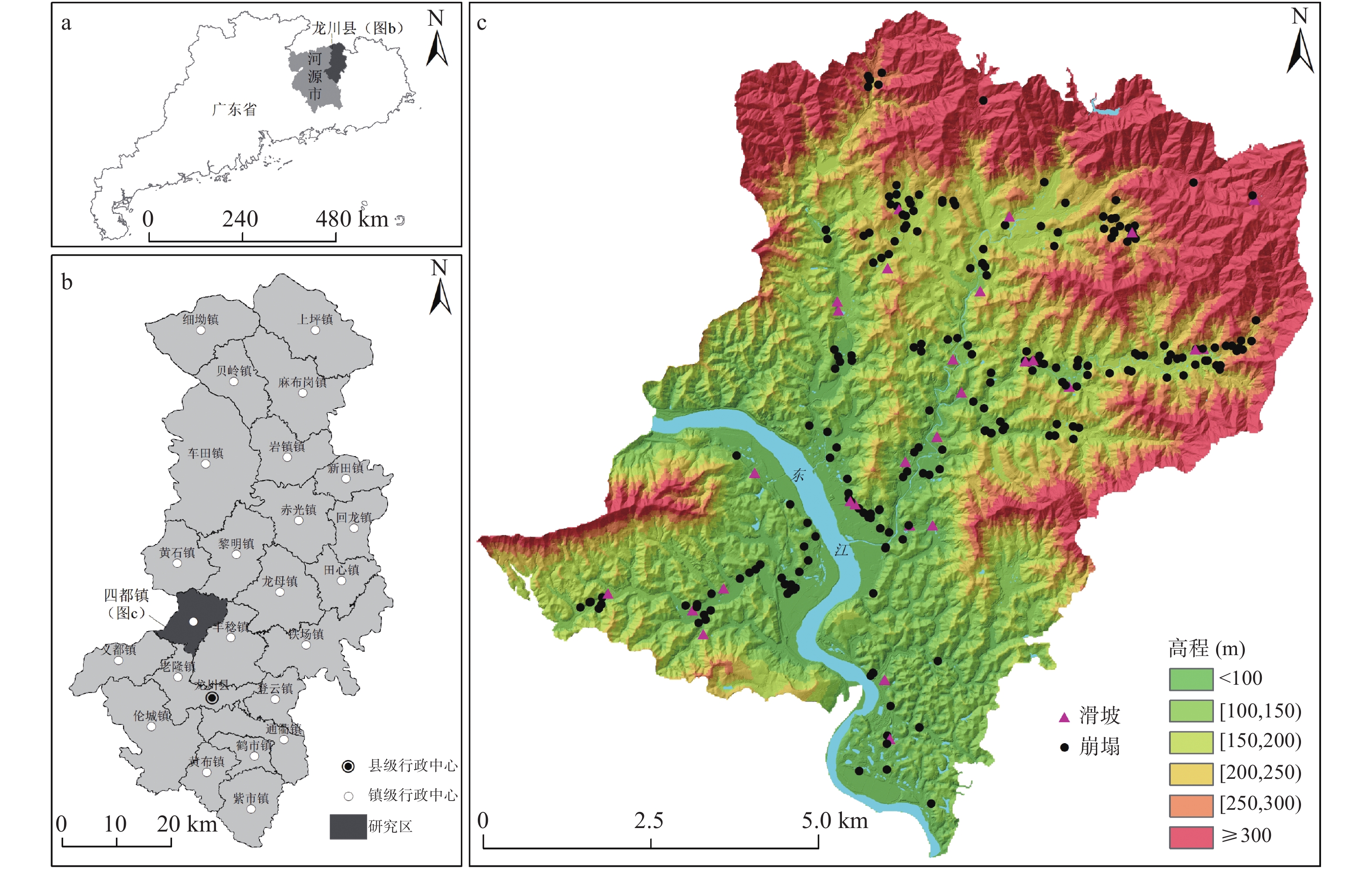
Figure 1.
Location of the study area (a, b) and distribution map of landslide disaster (c)
-
Figure 2.
Evaluation factors and grading for the susceptibility to various collapse and landslide disasters in Sidu Town
-
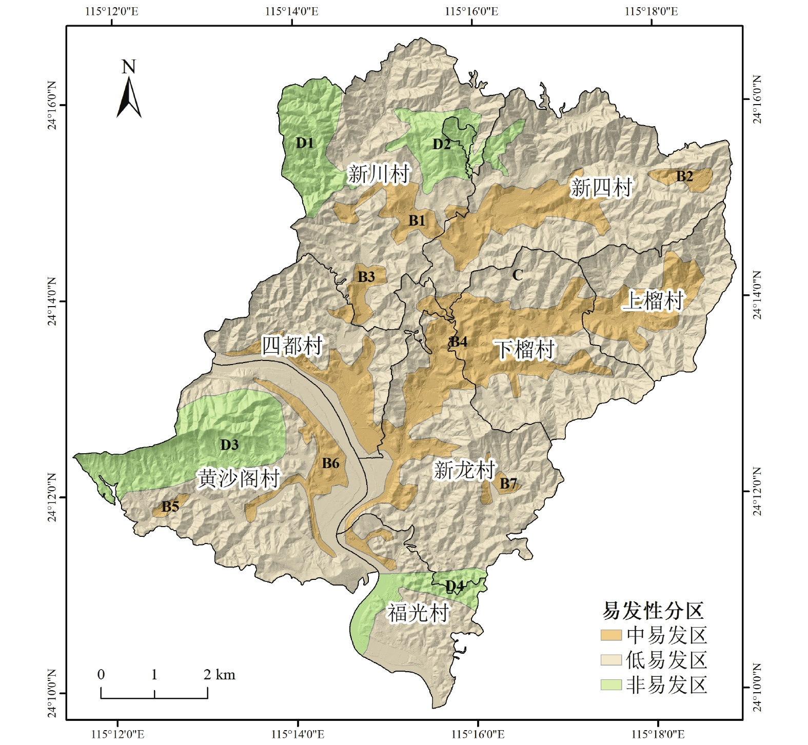
Figure 3.
Landslide and collapse disaster susceptibility zoning of Sidu town
-
Figure 4.
24-hour cumulative rainfall of 100 mm - risk area classification for Sidu Town
-
Figure 5.
24-hour cumulative rainfall of 250 mm - risk area classification for Sidu Town