

| Citation: |
Zhiqiang Yang, Wen-wen Qi, Chong Xu, Xiao-yi Shao, 2024. Exploring deep learning for landslide mapping: A comprehensive review, China Geology, 7, 329-349. doi: 10.31035/cg2024032

|
Exploring deep learning for landslide mapping: A comprehensive review
-
Abstract
A detailed and accurate inventory map of landslides is crucial for quantitative hazard assessment and land planning. Traditional methods relying on change detection and object-oriented approaches have been criticized for their dependence on expert knowledge and subjective factors. Recent advancements in high-resolution satellite imagery, coupled with the rapid development of artificial intelligence, particularly data-driven deep learning algorithms (DL) such as convolutional neural networks (CNN), have provided rich feature indicators for landslide mapping, overcoming previous limitations. In this review paper, 77 representative DL-based landslide detection methods applied in various environments over the past seven years were examined. We analyze the structures of different DL networks, discuss on five main application scenarios, and assess both the advancements and limitations of DL in geological hazard analysis. The results indicated that the increasing number of articles per year reflects growing interest in landslide mapping by artificial intelligence, with U-Net-based structures gaining prominence due to their flexibility in feature extraction and generalization. Finally, we explored the hindrances of DL in landslide hazard research based on the above research content. Challenges such as black-box operations and sample dependence persist, warranting further theoretical research and future application of DL in landslide detection.
-

-
References
Abiodun OI, Jantan A, Omolara AE, Dada KV, Mohamed NA, Arshad H. 2018. State of the art in artificial neural network applications: A survey. Heliyon, 4(11). doi: 10.1016/j.heliyon.2018.e00938. Amit SNKB, Aoki Y (2017). Disaster detection from aerial imagery with convolutional neural network. 2017 International Electronics Symposium on Knowledge Creation and Intelligent Computing, 239–245. doi: 10.1109/KCIC.2017.8228593. Amit SNKB, Shiraishi S, Inoshita T, Aoki Y. 2016. Analysis of satellite images for disaster detection. IEEE International Geoscience and Remote Sensing Symposium (IGARSS), 5189–5192. doi: 10.1109/IGARSS.2016.7730352. Anantharaman R, Velazquez M, Lee Y (2018). Utilizing Mask R-CNN for detection and segmentation of oral diseases. 2018 IEEE International Conference on Bioinformatics and Biomedicin, 2197–2204. doi: 10.1109/BIBM.2018.8621112 Assilzadeh H, Levy JK, Wang X. 2010. Landslide catastrophes and disaster risk reduction: A GIS framework for landslide prevention and management. Remote Sensing, 2(9), 2259–2273. doi: 10.3390/rs2092259. Ball JE, Anderson DT, Chan CS. 2017. A comprehensive survey of deep learning in remote sensing: Theories, tools, and challenges for the community. Journal of Applied Remote Sensing, 11(04), 042609–042609. doi: 10.1117/1.JRS.11.042609. Bharati P, Pramanik A. 2020. Deep Learning Techniques—R-CNN to Mask R-CNN: A Survey. Computational Intelligence in Pattern Recognition, 999, 657–668. doi: 10.1007/978-981-13-9042-5_56. Bragagnolo L, Rezende LR, da Silva RV, Grzybowski JMV. 2021. Convolutional neural networks applied to semantic segmentation of landslide scars. Catena, 201. doi: 10.1016/j.catena.2021.105189. Brardinoni F, Slaymaker O, Hassan MA. 2003. Landslide inventory in a rugged forested watershed: A comparison between air-photo and field survey data. Geomorphology, 54(3–4), 179–196. doi: 10.1016/s0169-555x(02)00355-0. Breiman L. 2001. Random forests. Machine Learning, 45(1), 5–32. doi: 10.1023/A:1010933404324. Bui T, Du P, Lum K, Chen C, Shiu S. 2019. Using BEMD in cnn to identify landslide in satellite image. International Conference on System Science and Engineering, 94–97. doi: 10.1109/ICSSE.2019.8823128. Bui T, Du P, Lum K, Loh C, Tan K. 2020. Deep learning for landslide recognition in satellite architecture. IEEE Access, 8, 143665–143678. doi: 10.1109/ACCESS.2020.3014305. Cai H, Chen T, Niu R, Plaza A. 2021. Landslide detection using densely connected convolutional networks and environmental conditions. IEEE Journal of Selected Topics in Applied Earth Observations and Remote Sensing, 14, 5235–5247. doi: 10.1109/jstars.2021.3079196. Carrara A, Cardinali M, Detti R, Guzzetti F, Pasqui V, Reichenbach P. 1991. GIS techniques and statistical models in evaluating landslide hazard. Earth Surface Processes and Landforms, 16(5), 427–445. doi: 10.1002/esp.3290160505. Casadei M, Dietrich WE, Miller NL. 2003. Testing a model for predicting the timing and location of shallow landslide initiation in soil-mantled landscapes. Earth Surface Processes and Landforms, 28(9), 925–950. doi: 10.1002/esp.3290160505. Catani F. 2021. Landslide detection by deep learning of non-nadiral and crowdsourced optical images. Landslides, 18(3), 1025–1044. doi: 10.1007/s10346-020-01513-4. Chacón J, Irigaray C, Fernández T, El Hamdouni R. 2006. Engineering geology maps: landslides and geographical information systems. Bulletin of Engineering Geology and the Environment, 65(4), 341–411. doi: 10.1007/s10064-006-0064-z. Chen B, Song C, Chen Y, Li ZH, Yu, Liu HH, Jiang H, Liu ZJ, Cai XM, Neng YH, Zhu S, Du JT, Li ZF, Zhao ZX, Li SJ, Zhu W, Peng JB. 2023. Emergency identification and influencing factor analysis of coseismic landslides and building damages induced by the 2023 Ms 6.2 Jishishan (Gansu, China) earthquake. Geomatics and Information Science of Wuhan University, 1–16. doi: 10.13203/J.whugis20230497 (in Chinese with English abstract). Chen Z, Zhang YF, Ouyang C, Zhang F, Ma J. 2018. Automated landslides detection for mountain cities using multi-temporal remote sensing imagery. Sensors, 18(3)doi: 10.3390/s18030821. Cheng G, Xie XX, Han JW, Guo L, Xia GS. 2020. Remote sensing image scene classification meets deep learning: Challenges, methods, benchmarks, and opportunities. IEEE Journal of Selected Topics in Applied Earth Observations and Remote Sensing, 13, 3735–3756. doi: 10.1109/jstars.2020.3005403. Cheng LB, Li J, Duan P, Wang MG. 2021. A small attentional YOLO model for landslide detection from satellite remote sensing images. Landslides, 18(8), 2751–2765. doi: 10.1007/s10346-021-01694-6. Chi MM, Plaza A, Benediktsson JA, Sun ZY, Shen JS, Zhu YY. 2016. Big data for remote sensing: Challenges and opportunities. Proceedings of the IEEE, 104(11), 2207–2219. doi: 10.1109/jproc.2016.2598228. Coe JA, Glancy PA, Whitney JW. 1997. Volumetric analysis and hydrologic characterization of a modern debris flow near Yucca Mountain, Nevada. Geomorphology, 20(1–2), 11–28. doi: 10.1016/S0169-555X(97)00008-1. Dai FC, Lee CF. 2002. Landslide characteristics and slope instability modeling using GIS, Lantau Island, Hong Kong. Geomorphology, 42(3-4), 213–228. doi: 10.1016/S0169-555X(01)00087-3. Ding AZ, Zhang QY, Zhou XM, Dai BC (2016). Automatic recognition of landslide based on CNN and texture change detection. 2016 31st Youth Academic Annual Conference of Chinese Association of Automation, 444–448. doi: 10.1109/YAC.2016.7804935. Dosovitskiy A, Beyer L, Kolesnikov A, Weissenborn D, Zhai X, Unterthiner T, Dehghani M, Minderer M, Heigold G, Gelly S, Uszkoreit J, Houlsby N (2021). An image is worth 16x16 words: Transformers for image recognition at scale. arXiv preprint arXiv: 2010.11929,doi: 10.48550/arXiv.2010.11929. Duman TY, Çan T, Emre Ö, Keçer M, Doğan A, Ateş Ş, Durmaz S. 2005. Landslide inventory of northwestern Anatolia, Turkey. Engineering Geology, 77(1–2), 99–114. doi: 10.1016/j.enggeo.2004.08.005. Fakoor R, Ladhak F, Nazi A, Huber M. 2013. Using deep learning to enhance cancer diagnosis and classification. Proceedings of the international conference on machine learning, 28, 3937–3949. Fan XM, Scaringi G, Korup O, West AJ, Van Westen CJ, Tanyas H, Hovius N, Hales TC, Jibson RW, Allstadt KE, Zhang LM, Evans SG, Xu C, Li G, Pei XJ, Xu Q, Huang RQ. 2019. Earthquake-induced chains of geologic hazards: Patterns, mechanisms, and impacts. Reviews of Geophysics, 57(2), 421–503. doi: 10.1029/2018RG000626. Fang CY, Fan XM, Zhong H, Lombardo L, Tanyas H, Wang X. 2022. A novel historical landslide detection approach based on LiDAR and lightweight attention U-Net. Remote Sensing, 14(17), 4357. doi: 10.3390/rs14174357. Fu R, He J, Liu G, Li WL, Mao JQ, He MH, Lin YY. 2022. Fast seismic landslide detection based on improved Mask R-CNN. Remote Sensing, 14(16), 3928. doi: 10.3390/rs14163928. Gardner MW, Dorling SR. 1998. Artificial neural networks (the multilayer perceptron)—A review of applications in the atmospheric sciences. Atmospheric Environment, 32(14-15), 2627–2636. doi: 10.1016/S1352-2310(97)00447-0. Ghorbanzadeh O, Blaschke T (2019). Optimizingsample patches selection of CNN to improve the mIOU on landslide detection. Proceedings of the 5th International Conference on Geographical Information Systems Theory, Applications and Management, 1(33–40). doi: 10.5220/0007675300330040. Ghorbanzadeh O, Blaschke T, Gholamnia K, Meena S, Tiede D, Aryal J. 2019. Evaluation of different machine learning methods and deep-Learning convolutional neural networks for landslide detection. Remote Sensing, 11(2), 196. doi: 10.3390/rs11020196. Ghorbanzadeh O, Crivellari A, Ghamisi P, Shahabi H, Blaschke T. 2021. A comprehensive transferability evaluation of U-Net and ResU-Net for landslide detection from Sentinel-2 data (case study areas from Taiwan, China, and Japan). Scientific Reports, 11(1), 14629. doi: 10.1038/s41598-021-94190-9. Ghorbanzadeh O, Gholamnia K, Ghamisi P. 2022. The application of ResU-Net and OBIA for landslide detection from multi-temporal Sentinel-2 images. Big Earth Data, 7(4), 961–985. doi: 10.1080/20964471.2022.2031544. Ghorbanzadeh O, Shahabi H, Crivellari A, Homayouni S, Blaschke T, Ghamisi P. 2022. Landslide detection using deep learning and object-based image analysis. Landslides, 19(4), 929–939. doi: 10.1007/s10346-021-01843-x. Ghorbanzadeh O, Xu Y, Ghamisi P, Kopp M, Kreil D. 2022. Landslide4Sense: Reference benchmark data and deep learning models for landslide detection, EEE Transactions on Geoscience and Remote Sensing, 60, 1–17. doi: 10.1109/TGRS.2022.3215209. Glade T. 2001. Landslide Hazard Assessment and Historical Landslide Data-An Inseparable Couple? Spring. Netherlands, 153–168. Guo HJ, Yi BJ, Yao QX, Gao P, Li H, Sun JX, Zhong C. 2022. Identification of landslides in mountainous area with the combination of SBAS-InSAR and Yolo model. Sensors, 22(16), 6235. doi: 10.3390/s22166235. Guzzetti F, Mondini AC, Cardinali M, Fiorucci F, Santangelo M, Chang K-T. 2012. Landslide inventory maps: New tools for an old problem. Earth-Science Reviews, 112(1–2), 42–66. doi: 10.1016/j.earscirev.2012.02.001. Hacıefendioğlu K, Demir G, Başağa HB. 2021. Landslide detection using visualization techniques for deep convolutional neural network models. Natural Hazards, 109(1), 329–350. doi: 10.1007/s11069-021-04838-y. He HQ, Li CC, Yang RH, Zeng HE, Li L, Zhu YF. 2022. Multisource data fusion and adversarial nets for landslide extraction from UAV-photogrammetry-derived data. Remote Sensing, 14(13), 3059. doi: 10.3390/rs14133059. He KM, Gkioxari G, Dollár P, Girshick R (2018). Mask R-CNN. arXiv preprint arXiv: 1703.06870,doi: 10.48550/arXiv.1703.06870. He KM, Zhang XY, Ren SQ, Sun J (2016). Deep residual learning for image recognition. 2016 IEEE Conference on Computer Vision and Pattern Recognition. 770–778. doi: 10.1109/CVPR.2016.90. Hong Y, Adler R, Huffman G. 2007. Use of satellite remote sensing data in the mapping of global landslide susceptibility. Natural Hazards, 43(2), 245–256. doi: 10.1007/s11069-006-9104-z. Hu Q, Zhou Y, Wang SX, Wang FT, Wang HJ. 2019. Improving the accuracy of landslide detection in “Off-site” area by machine learning model portability comparison: A case study of Jiuzhaigou earthquake, China. Remote Sensing, 11(21), 2530. doi: 10.3390/rs11212530. Hua YM, Guo JH, Zhao H. 2015. Deep belief networks and deep learning. Proceedings of 2015 International Conference on Intelligent Computing and Internet of Things, 1–4. doi: 10.1109/ICAIOT.2015.7111524. Huang G, Liu Z, van der Maaten L, Weinberger KQ. 2018. Densely connected convolutional networks. 2017 IEEE Conference on Computer Vision and Pattern Recognition, 2261–2269. doi: 10.1109/CVPR.2017.243. Huang J, Li X, Chen F, Cui R, Li HM, Du BW. 2022. A deep learning recognition model for landslide terrain based on multi-source data fusion. The Chinese Journal of Geological Hazard and Control, 33(2), 33–41. doi: 10.16031/j.cnki.issn.1003-8035.2022.02-05. Huang YD, Xu C, Zhang XJ, Li L. 2022. Bibliometric analysis of landslide research based on the WOS database. Natural Hazards Research, 2(2), 49–61. doi: 10.1016/j.nhres.2022.02.001. Huang YD, Xu C, Zhang XL, Xue CJ, Wang SY. 2021. An updated database and spatial distribution of landslides triggered by the Milin, Xizang Mw6. 4 earthquake of 18 November 2017. Journal of Earth Science, 32(5), 1069–1078. doi: 10.1007/s12583-021-1433-z. Janiesch C, Zschech P, Heinrich K. 2021. Machine learning and deep learning. Electronic Markets, 31(3), 685–695. doi: 10.1007/s12525-021-00475-2. Ji SP, Yu Dw, Shen CY, Li WL, Xu Q. 2020. Landslide detection from an open satellite imagery and digital elevation model dataset using attention boosted convolutional neural networks. Landslides, 17(6), 1337–1352. doi: 10.1007/s10346-020-01353-2. Ju YQ, Xu Q, Jin SC, Li WL, Dong XJ, Guo QH. 2020. Automatic object detection of loess landslide based on deep learning. Geomatics and Information Science of Wuhan University, 45(11), 1747–1755. doi: 10.13203/j.whugis20200132. Ju YZ, Xu Q, Jin SC, Li WL, Su YJ, Dong XJ, Guo QH. 2022. Loess landslide detection using object detection algorithms in northwest China. Remote Sensing, 14(5), 1182. doi: 10.3390/rs14051182. Kattenborn T, Leitloff J, Schiefer F, Hinz S. 2021. Review on convolutional neural networks (CNN) in vegetation remote sensing. ISPRS Journal of Photogrammetry and Remote Sensing, 173, 24–49. doi: 10.1016/j.isprsjprs.2020.12.010. Konishi T, Suga Y, Notarnicola C, Pierdicca N, Bovenga F, Santi E. 2019. Landslide detection with ALOS-2/PALSAR-2 data using convolutional neural networks: A case study of 2018 Hokkaido Eastern Iburi earthquake. Active and Passive Microwave Remote Sensing for Environmental Monitoring III, 111540. doi: 10.1117/12.2531695. Larochelle H, Mandel M, Pascanu R, Bengio Y. 2012. Learning algorithms for the classification restricted boltzmann machine. Journal of Machine Learning Research, 13(22), 643–669. LeCun Y, Bengio Y, Hinton G. 2015. Deep learning. Nature, 521(7553), 436–444. doi: 10.1038/nature14539. Lei T, Zhang Q, Xue DH, Chen T, Meng HY, Nandi AK. 2019. End-to-end change detection using a symmetric fully convolutional network for landslide mapping. IEEE International Conference on Acoustics, Speech and Signal Processing, 3027–3031. doi: 10.1109/ICASSP.2019.8682802. Lei T, Zhang YX, Lv ZY, Li SY, Liu SG, Nandi AK. 2019. Landslide inventory mapping from bitemporal images using deep convolutional neural networks. IEEE Geoscience and Remote Sensing Letters, 16(6), 982–986. doi: 10.1109/lgrs.2018.2889307. Li C, Yi BJ, Gao P, Li H, Sun JX, Chen XY, Zhong C. 2021. Valuable clues for DCNN-based landslide detection from a comparative assessment in the wenchuan earthquake area. Sensors, 21(15)doi: 10.3390/s21155191. Li YS, Ma JY, Zhang YJ. 2021. Image retrieval from remote sensing big data: A survey. Information Fusion, 67, 94–115. doi: 10.1016/j.inffus.2020.10.008. Li ZB, Shi WZ, Myint SW, Lu P, Wang QM. 2016. Semi-automated landslide inventory mapping from bitemporal aerial photographs using change detection and level set method. Remote Sensing of Environment, 175, 215–230. doi: 10.1016/j.rse.2016.01.003. Liou CY, Cheng WC, Liou JW, Liou DR. 2014. Autoencoder for words. Neurocomputing, 139, 84–96. doi: 10.1016/j.neucom.2013.09.055. Liu J, Li PF. 2018. A Mask R-CNN model with improved region proposal network for medical ultrasound image. Intelligent Computing Theories and Application, 10955, 26–33. doi: 10.1007/978-3-319-95933-7_4. Liu P, Di LP, Du Q, Wang LZ. 2018. Remote sensing big data: Theory, methods and applications. Remote Sensing, 10(5), 711. doi: 10.3390/rs10050711. Liu P, Wei YM, Wang QJ, Chen Y, Xie JJ. 2020. Research on post-earthquake landslide extraction algorithm based on improved U-Net model. Remote Sensing, 12(5), 894. doi: 10.3390/rs12050894. Liu T, Chen T, Niu RQ, Plaza A. 2021. Landslide detection mapping employing CNN, ResNet, and DenseNet in the Three Gorges Reservoir, China. IEEE Journal of Selected Topics in Applied Earth Observations and Remote Sensing, 14, 11417–11428. doi: 10.1109/jstars.2021.3117975. Liu Y, Wu LZ. 2016. Geological disaster recognition on optical remote sensing images using deep learning. Procedia Computer Science, 91, 566–575. doi: 10.1016/j.procs.2016.07.144. Liu Y, Wu LZ. 2018. High performance geological disaster recognition using deep learning. Procedia Computer Science, 139, 529–536. doi: 10.1016/j.procs.2018.10.237. Liu Y, Yao X, Gu ZK, Zhou ZK, Liu XH, Chen XM, Wei SF. 2022. Study of the automatic recognition of landslides by using InSAR images and the improved Mask R-CNN model in the eastern Xizang Plateau. Remote Sensing, 14(14), 3362. doi: 10.3390/rs14143362. Long J, Shelhamer E, Darrell T. 2015. Fully convolutional networks for semantic segmentation. 2015 IEEE Conference on Computer Vision and Pattern Recognition, 3431–3440. doi: 10.1109/CVPR.2015.7298965. Long LJ, He F, Liu HJ. 2021. The use of remote sensing satellite using deep learning in emergency monitoring of high-level landslides disaster in Jinsha River. The Journal of Supercomputing, 77(8), 8728–8744. doi: 10.1007/s11227-020-03604-4. Lu H, Ma L, Fu X, Liu C, Wang Z, Tang M, Li NW. 2020. Landslides information extraction using Object-Oriented image analysis paradigm based on deep learning and transfer learning. Remote Sensing, 12(5), 752. doi: 10.3390/rs12050752. Lu P, Shi WY, Wang QM, Li ZB, Qin YY, Fan XM. 2021. Coseismic landslide mapping using Sentinel-2 10m fused NIR narrow, red-edge, and SWIR bands. Landslides, 18(6), 2017–2037. doi: 10.1007/s10346-021-01636-2. Lv ZY, Liu TF, Kong XB, Shi C, Benediktsson JA. 2020. Landslide inventory mapping with bitemporal aerial remote sensing images based on the dual-path fully convolutional network. IEEE Journal of Selected Topics in Applied Earth Observations and Remote Sensing, 13, 4575–4584. doi: 10.1109/jstars.2020.2980895. Ma ZJ, Mei G. 2021. Deep learning for geological hazards analysis: Data, models, applications, and opportunities. Earth-Science Reviews, 223, 103858. doi: 10.1016/j.earscirev.2021.103858. Mabu S, Hirata S, Kuremoto T. 2021. Landslide area detection from synthetic aperture radar images using convolutional adversarial autoencoder and one-class SVM. Proceedings of International Conference on Artificial Life and Robotics, 26, 575–580 doi: 10.5954/ICAROB.2021.GS4-1. Malamud BD, Turcotte DL, Guzzetti F, Reichenbach P. 2004. Landslide inventories and their statistical properties. Earth Surface Processes and Landforms, 29(6), 687–711. doi: 10.1002/esp.1064. Maxwell AE, Warner TA, Fang F. 2018. Implementation of machine learning classification in remote sensing: An applied review. International Journal of Remote Sensing, 39(9), 2784–2817. doi: 10.1080/01431161.2018.1433343. Meena SR, Soares LP, Grohmann CH, van Westen C, Bhuyan K, Singh RP, Floris M, Catani F. 2022. Landslide detection in the Himalayas using machine learning algorithms and U-Net. Landslides, 19(5), 1209–1229. doi: 10.1007/s10346-022-01861-3. Meng QX, Catchpoole D, Skillicom D, Kennedy PJ. 2017. Relational autoencoder for feature extraction. 2017 International Joint Conference on Neural Networks, 364–371. doi: 10.1109/IJCNN.2017.7965877. Micheletti N, Foresti L, Robert S, Leuenberger M, Pedrazzini A, Jaboyedoff M, Kanevski M. 2014. Machine learning feature selection methods for landslide susceptibility mapping. Mathematical Geosciences, 46(1), 33–57. doi: 10.1007/s11004-013-9511-0. Mohan A, Singh AK, Kumar B, Dwivedi R. 2021. Review on remote sensing methods for landslide detection using machine and deep learning. Transactions on Emerging Telecommunications Technologies, 32(7). doi: 10.1002/ett.3998. Mondini AC, Guzzetti F, Chang K-T, Monserrat O, Martha TR, Manconi A. 2021. Landslide failures detection and mapping using synthetic aperture radar: Past, present and future. Earth-Science Reviews, 216. doi: 10.1016/j.earscirev.2021.103574. Moosavi V, Talebi A, Shirmohammadi B. 2014. Producing a landslide inventory map using pixel-based and object-oriented approaches optimized by Taguchi method. Geomorphology, 204, 646–656. doi: 10.1016/j.geomorph.2013.09.012. Nalisnick E, Matsukawa A, Teh YW, Gorur D, Lakshminarayanan B. 2019. Do deep generative models know what they don't know? arXiv preprint arXiv: 1810.09136,doi: 10.48550/arXiv.1810.09136. Nava L, Bhuyan K, Meena SR, Monserrat O, Catani F. 2022. Rapid mapping of landslides on SAR data by attention U-Net. Remote Sensing, 14(6), 1449. doi: 10.3390/rs14061449. Nick TG, Campbell KM. 2007. Logistic regression, NJ, Humana Press. 404, 273–301. doi: 10.1007/978-1-59745-530-5_14. Noble WS. 2006. What is a support vector machine? Nature Biotechnology, 24(12). doi: 10.1038/nbt1206-1565. Pang DD, Liu G, He J, Li WL, Fu R. 2022. Automatic remote sensing identification of coseismic landslides using deep learning methods. Forests, 13(8), 1213. doi: 10.3390/f13081213. Pardeshi SD, Autade SE, Pardeshi SS. 2013. Landslide hazard assessment: Recent trends and techniques. SpringerPlus, 2(1), 523. doi: 10.1186/2193-1801-2-523. Postance B, Hillier J, Dijkstra T, Dixon N. 2018. Comparing threshold definition techniques for rainfall-induced landslides: A national assessment using radar rainfall: Comparing threshold techniques for rainfall induced landslides. Earth Surface Processes and Landforms, 43(2), 553–560. doi: 10.1002/esp.4202. Poursanidis D, Chrysoulakis N. 2017. Remote Sensing, natural hazards and the contribution of ESA Sentinels missions. Remote Sensing Applications: Society and Environment, 6, 25–38. doi: 10.1016/j.rsase.2017.02.001. Prakash N, Manconi A, Loew S. 2020. Mapping landslides on EO data: Performance of deep learning models vs. Traditional machine learning models. Remote Sensing, 12(3), 346. doi: 10.3390/rs12030346. Qi WW, Wei MF, Yang WT, Xu C, Ma C. 2020. Automatic mapping of landslides by the ResU-Net. Remote Sensing, 12(15), 2487. doi: 10.3390/rs12152487. Qin SW, Guo X, Sun JB, Qiao SS, Zhang LS, Yao JY, Cheng QS, Zhang YQ. 2021. Landslide detection from open satellite imagery using distant domain transfer learning. Remote Sensing, 13(17), 3383. doi: 10.3390/rs13173383. Ronneberger O, Fischer P, Brox T (2015). U-Net: Convolutional networks for biomedical image segmentation. arXiv preprint arXiv: 1505.04597,doi: 10.48550/arXiv.1505.04597. Saha AK, Gupta RP, Sarkar I, Arora MK, Csaplovics E. 2005. An approach for GIS-based statistical landslide susceptibility zonation—with a case study in the Himalayas. Landslides, 2(1), 61–69. doi: 10.1007/s10346-004-0039-8. Salakhutdinov R. 2015. Learning Deep Generative Models. Annual review of statistics and its application, 2(1), 361–385. doi: 10.1146/annurev-statistics-010814-020120. Sameen MI, Pradhan B. 2019. Landslide detection using residual networks and the fusion of spectral and topographic information. IEEE Access, 7, 114363–114373. doi: 10.1109/access.2019.2935761. Samia J, Temme A, Bregt A, Wallinga J, Guzzetti F, Ardizzone F, Rossi M. 2017. Do landslides follow landslides? Insights in path dependency from a multi-temporal landslide inventory. Landslides, 14(2), 547–558. doi: 10.1007/s10346-016-0739-x. Schönfeldt E, Winocur D, Pánek T, Korup O. 2022. Deep learning reveals one of Earth's largest landslide terrain in Patagonia. Earth and Planetary Science Letters, 593. doi: 10.1016/j.jpgl.2022.117642. Shahabi H, Rahimzad M, Tavakkoli Piralilou S, Ghorbanzadeh O, Homayouni S, Blaschke T, Lim S, Ghamisi P. 2021. Unsupervised deep learning for landslide detection from multispectral Sentinel-2 imagery. Remote Sensing, 13(22), 4698. doi: 10.3390/rs13224698. Shao XY, Ma SY, Xu C, Zhang PF, Wen BY, Tian YY, Zhou Q, Cui YL. 2019. Planet image-based inventorying and machine learning-based susceptibility mapping for the landslides triggered by the 2018 Mw6.6 Tomakomai, Japan earthquake. Remote Sensing, 11(8), 978. doi: 10.3390/rs11080978. Shi WZ, Zhang M, Ke HF, Fang X, Zhan Z, Chen SX. 2021. Landslide recognition by deep convolutional neural network and change detection. IEEE Transactions on Geoscience and Remote Sensing, 59(6), 4654–4672. doi: 10.1109/tgrs.2020.3015826. Shi Y, Shi LL, Niu MJ, Zhao K. 2022. Multi-task automatic identification of loess landslide based on one-stage instance segmentation network. Bulletin of Survey and Mapping, 0(4), 26–31. doi: 10.13474/j.cnki.11-2246.2022.0105. Simonyan K, Zisserman A. 2015. Very deep convolutional networks for large-scale image recognition. arXiv preprint arXiv: 1409.1556,doi: 10.48550/arXiv.1409.1556. Soares LP, Dias HC, Garcia GPB, Grohmann CH. 2022. Landslide segmentation with deeplearning: Evaluating model generalization in rainfall-induced landslides in Brazil. Remote Sensing, 14(9), 2237. doi: 10.3390/rs14092237. Soares LP, Dias HC, Grohmann CH. 2020. Landslide segmentation with U-Net: Evaluating different sampling methods and patch sizes. arXiv preprint arXiv: 2007.06672,doi: 10.48550/arXiv.2007.06672. Sohn I. 2021. Deep belief network based intrusion detection techniques: A survey. Expert Systems with Applications, 167. doi: 10.1016/j.eswa.2020.114170. Song YY, Lu Y. 2015. Decision tree methods: Applications for classification and prediction. Shanghai Archives of Psychiatry, 27(2), 130–5. doi: 10.11919/j.issn.1002-0829.215044. Stumpf A, Kerle N. 2011. Object-oriented mapping of landslides using random forests. Remote Sensing of Environment, 115(10), 2564–2577. doi: 10.1016/j.rse.2011.05.013. Su ZY, Chow JK, Tan PS, Wu J, Ho YK, Wang YH. 2021. Deep convolutional neural network–based pixel-wise landslide inventory mapping. Landslides, 18(4), 1421–1443. doi: 10.1007/s10346-020-01557-6. Sun Y, Wang XG, Tang XO. 2014. Deep learningface representation from predicting 10, 000 classes. 2014 IEEE Conference on Computer Vision and Pattern Recognition, 1891–1898. doi: 10.1109/CVPR.2014.244. Tanatipuknon A, Aimmanee P, Watanabe Y, Murata KT, Wakai A, Sato G, Hung HV, Tungpimolrut K, Keerativittayanun S, Karnjana J. 2021. Study on combining two faster R-CNN models for landslide detection with a classification decision tree to Improve the detection performance. Journal of Disaster Research, 16(4), 588–595. doi: 10.20965/jdr.2021.p0588. Tang XC, Liu MZ, Zhong H, Ju YZ, Li WL, Xu Q. 2021. MILL: Channel attention–based deep multiple instance learning for landslide recognition. ACM Transactions on Multimedia Computing, Communications, and Applications, 17(2s), 1–11. doi: 10.1145/3454009. Tang XC, Tu ZH, Wang Y, Liu MZ, Li DF, Fan XM. 2022. Automatic detection of coseismic landslides using a new transformer method. Remote Sensing, 14(12), 2884. doi: 10.3390/rs14122884. Tehrani FS, Calvello M, Liu Z, Zhang L, Lacasse S. 2022. Machine learning and landslide studies: Recent advances and applications. Natural Hazards, 114, 1197–1245. doi: 10.1007/s11069-022-05423-7. Tschannen M, Bachem O, Lucic M. 2018. Recent advances in autoencoder-based representation learning. arXiv preprint arXiv: 1812.05069,doi: 10.48550/arXiv.1812.05069. Ullo S, Mohan A, Sebastianelli A, Ahamed S, Kumar B, Dwivedi R, Sinha GR. 2021. A new Mask R-CNN-based method for improved landslide detection. IEEE Journal of Selected Topics in Applied Earth Observations and Remote Sensing, 14, 3799–3810. doi: 10.1109/jstars.2021.3064981. Van Westen CJ, Castellanos E, Kuriakose SL. 2008. Spatial data for landslide susceptibility, hazard, and vulnerability assessment: An overview. Engineering Geology, 102(3–4), 112–131. doi: 10.1016/j.enggeo.2008.03.010. Wang HJ, Zhang LM, Yin KS, Luo HY, Li JH. 2021. Landslide identification using machine learning. Geoscience Frontiers, 12(1), 351–364. doi: 10.1016/j.gsf.2020.02.012. Wang Y, Wang XF, Jian JF. 2019. Remote sensing landslide recognition based on convolutional neural network. Mathematical Problems in Engineering, 2019, 1–12. doi: 10.1155/2019/8389368. Wieczorek GF. 1984. Preparing a detailed landslide inventory map for hazard evaluation and reduction. Environmental & Engineering Geoscience, xxi(3), 337–342. doi: 10.2113/gseegeosci.xxi.3.337. Woodcock CE, Strahler AH. 1987. The factor of scale in remote sensing. Remote Sensing of Environment, 21(3), 311–332. doi: 10.1016/0034-4257(87)90015-0. Xia W, Chen J, Liu JB, Ma CH, Liu W. 2021. Landslide extraction from high-resolution remote sensing imagery using fully convolutional spectral topographic fusion network. Remote Sensing, 13(24), 5116. doi: 10.3390/rs13245116. Xu C, Xu XW, Shyu JBH, Gao MX, Tan XB, Ran YK, Zheng WJ. 2015. Landslides triggered by the 20 April 2013 Lushan, China, Mw 6. 6 earthquake from field investigations and preliminary analyses. Landslides, 12(2), 365–385. doi: 10.1007/s10346-014-0546-1. Xu C, Xu XW, Yao X, Dai FC. 2014. Three (nearly) complete inventories of landslides triggered by the May 12, 2008 Wenchuan Mw 7. 9 earthquake of China and their spatial distribution statistical analysis. Landslides, 11(3), 441–46. doi: 10.1007/s10346-013-0404-6. Xu QS, Ouyang CJ, Jiang TH, Yuan X, Fan XM, Cheng DX. 2022. MFFENet and ADANet: A robust deep transfer learning method and its application in high precision and fast cross-scene recognition of earthquake-induced landslides. Landslides, 19(7), 1617–1647. doi: 10.1007/s10346-022-01847-1. Xu YL, Ouyang CJ, Xu QS, Wang DP, Zhao B, Luo YT. 2024. CAS Landslide Dataset: A Large-Scale and Multisensor Dataset for Deep Learning-Based Landslide Detection. Scientific Data, 11(1), 12. doi: 10.1038/s41597-023-02847-z. Yang J, Gong P, Fu R, Zhang MH, Chen JM, Liang SL, Xu B, Shi JC, Dickinson R. 2013. The role of satellite remote sensing in climate change studies. Nature Climate Change, 3(10), 875–883. doi: 10.1038/nclimate1908. Yang S, Wang YZ, Wang PZ, Mu JQ, Jiao ST, Zhao XP, Wang ZH, Wang KJ, Zhu YQ. 2022. Automatic identification of landslides based on deep learning. Applied Sciences, 12(16)doi: 10.3390/app12168153. Yang ZQ, Xu C. 2022. Efficient detection of earthquake−triggered landslides based on U−Net++: An example of the 2018 Hokkaido eastern Iburi (Japan) Mw 6. 6 earthquake. Remote Sensing, 14(12), 2826. doi: 10.3390/rs14122826. Yang ZQ, Xu C, Li L. 2022. Landslide detection based on ResU-Net with transformer and CBAM embedded: Two examples with geologically different environments. Remote Sensing, 14(12), 2885. doi: 10.3390/rs14122885. Yao GL, Zhou WL, Liu MZ, Xu Q, Wang HH, Li J, Ju YZ. 2022. An empirical study of the convolution neural networks based detection on object with ambiguous boundary in remote sensing imagery—A case of potential loess landslide. IEEE Journal of Selected Topics in Applied Earth Observations and Remote Sensing, 15, 323–338. doi: 10.1109/jstars.2021.3132416. Ye CM, Li Y, Cui P, Liang L, Pirasteh S, Marcato J, Goncalves WN, Li J. 2019. Landslide detection of hyperspectral remote sensing data based on deep learning with constrains. IEEE Journal of Selected Topics in Applied Earth Observations and Remote Sensing, 12(12), 5047–5060. doi: 10.1109/jstars.2019.2951725. Yi YN, Zhang WC. 2020. A new deep-learning-based approach for earthquake triggered landslide detection from single Temporal RapidEye satellite imagery. IEEE Journal of Selected Topics in Applied Earth Observations and Remote Sensing, 13, 6166–6176. doi: 10.1109/jstars.2020.3028855. Yu B, Chen F, Xu C. 2020. Landslide detection based on contour-based deep learning framework in case of national scale of Nepal in 2015. Computers & Geosciences, 135doi: 10.1016/j.cageo.2019.104388. Yu B, Chen F, Xu C, Wang L, Wang N. 2021. Matrix SegNet: A practical deep learning framework for landslide mapping from images of different areas with different spatial resolutions. Remote Sensing, 13(16), 3158. doi: 10.3390/rs13163158. Yu B, Xu C, Chen F, Wang N, Wang L. 2022. HADeenNet: A hierarchical-attention multi-scale deconvolution network for landslide detection. International Journal of Applied Earth Observation and Geoinformation, 111doi: 10.1016/j.jag.2022.102853. Yu H, Ma Y, Wang LF, Zhai YS, Wang XQ. 2017. A landslide intelligent detection method based on CNN and RSG_R. 2017 IEEE International Conference on Mechatronics and Automation, 40-44. doi: 10.1109/ICMA.2017.8015785. Zhang JM, Lu CQ, Li XD, Kim HJ, Wang J. 2019. A full convolutional network based on DenseNet for remote sensing scene classification. Mathematical Biosciences and Engineering, 16(5), 3345–3367. doi: 10.3934/mbe.2019167. Zhang M, Shi WZ, Chen SX, Zhan Z, Shi ZC. 2021. Deep multiple instance learning for landslide mapping. IEEE Geoscience and Remote Sensing Letters, 18(10), 1711–1715. doi: 10.1109/lgrs.2020.3007183. Zhang N, Ding SF, Zhang J, Xue Y. 2018. An overview of restricted boltzmann machines. Neurocomputing, 275, 1186–1199. doi: 10.1016/j.neucom.2017.09.065. Zhang PF, Xu C, Ma SY, Shao XY, Tian YY, Wen BY. 2020. Automatic extraction of seismic landslides in large areas with complex environments based on deep learning: An example of the 2018 Iburi earthquake, Japan. Remote Sensing, 12(23), 3992. doi: 10.3390/rs12233992. Zhang X, Zhou YN, Luo JC. 2021. Deep learning for processing and analysis of remote sensing big data: A technical review. Big Earth Data, 6(4), 527–560. doi: 10.1080/20964471.2021.1964879. Zhang XK, Pun MO, Liu M. 2021. Semi-supervised multi temporal deep representation fusion network for landslide mapping from aerial orthophotos. Remote Sensing, 13(4), 548. doi: 10.3390/rs13040548. Zhao W, Li AN, Nan X, Zhang ZJ, Lei GB. 2017. Postearthquake landslides mapping from Landsat-8 data for the 2015 Nepal earthquake using a pixel-based change detection method. IEEE Journal of Selected Topics in Applied Earth Observations and Remote Sensing, 10(5), 1758–1768. doi: 10.1109/jstars.2017.2661802. Zhong C, Liu Y, Gao P, Chen WL, Li H, Hou Y, Nuremanguli T, Ma HJ. 2020. Landslide mapping with remote sensing: Challenges and opportunities. International Journal of Remote Sensing, 41(4), 1555–1581. doi: 10.1080/01431161.2019.1672904. Zhou YX, Wang HH, Yang RH, Yao GL, Xu Q, Zhang XJ. 2022. A novel weakly supervised remote sensing landslide semantic segmentation method: Combining CAM and cycleGAN algorithms. Remote Sensing, 14(15), 3650. doi: 10.3390/rs14153650. Zhu GH, Piao ZW, Kim SC (2020). Tooth detection and segmentation with Mask R-CNN. 2020 International Conference on Artificial Intelligence in Information and Communication, 070-072. doi: 10.1109/ICAIIC48513.2020.9065216. Zhu XX, Tuia D, Mou LC, Xia GS, Zhang LP, Xu F, Fraundorfer F. 2017. Deep learning in remote sensing: A comprehensive review and list of resources. IEEE Geoscience and Remote Sensing Magazine, 5(4), 8–36. doi: 10.1109/mgrs.2017.2762307. -
Access History

Figures(19)

Export File
Citation
Zhiqiang Yang, Wen-wen Qi, Chong Xu, Xiao-yi Shao, 2024. Exploring deep learning for landslide mapping: A comprehensive review, China Geology, 7, 329-349. doi: 10.31035/cg2024032
Format
Content
 DownLoad:


-
Figure 1.
Global landslide catalog points collected by NASA (detailed information found in the website
https://maps.nccs.nasa.gov/ . -
Figure 2.
Morphology of landslides in remote sensing images in different regions and corresponding manual labels. Landslides in different areas show significant differences in remote sensing images. a-Coseismic landslides triggered by the 2022 MS 6.2 Luding (Sichuan, China) earthquake; b-2013 rainfall-triggered landslides in Tianshui (Gansu, China); c-Coseismic landslides triggered by the 2018 MW 6.6 Iburi, Japan earthquake; d-Coseismic landslides MS 8.0 Wenchuan (Sichuan, China) earthquake.
-
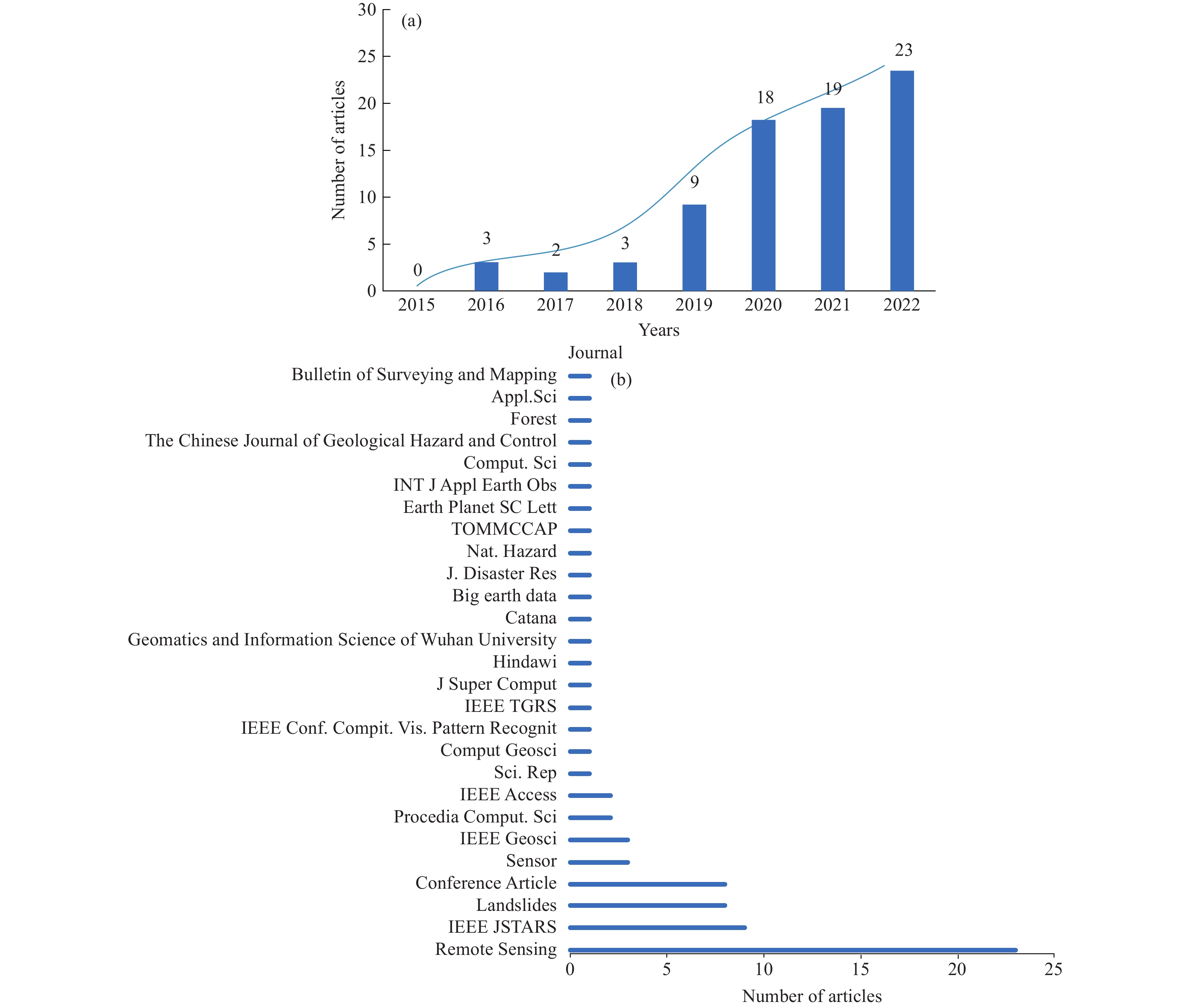
Figure 3.
Literature database information. a–Number of articles published per year from 2015.1-2022.9; b–Name of the journal in which the literature was published.
-
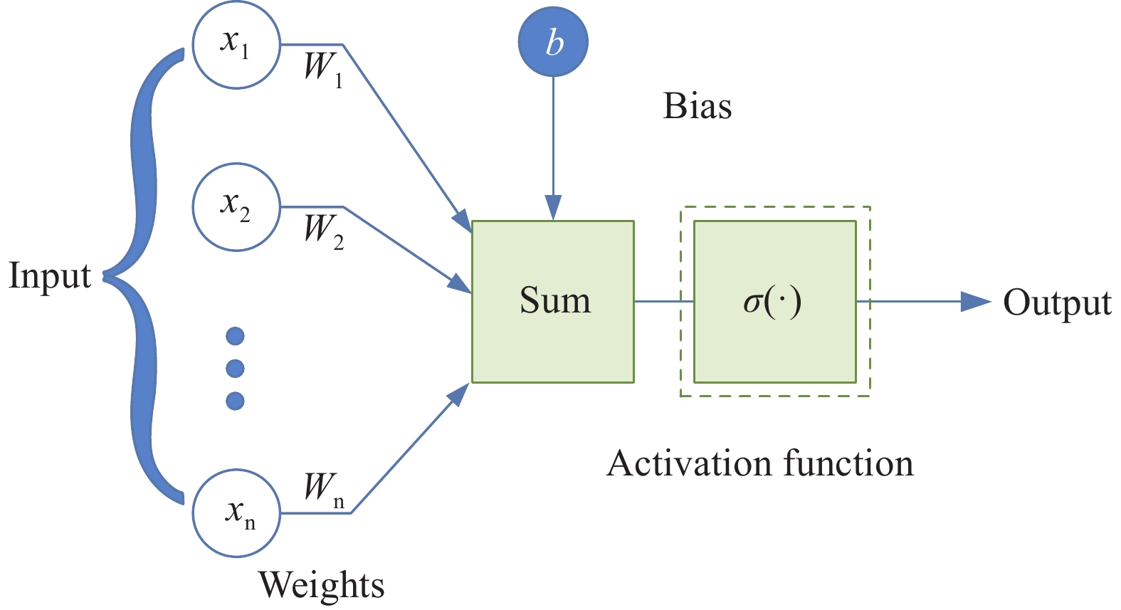
Figure 4.
Process of forward propagation of artificial neural networks. All inputs transformed by linear transformation and fed into activation functions converting to nonlinear expressions as outputs.
-
Figure 5.
Structure of Multilayer perceptron. Each neuron connected to all neurons in the previous layer, and the final output is two classes characterizing landslide and no-landslide.
-
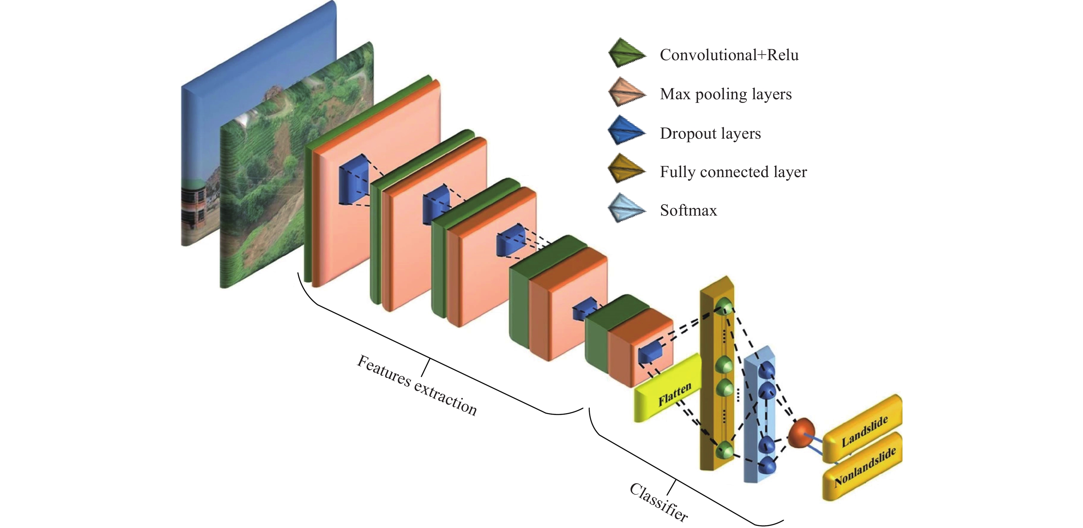
Figure 6.
Typical convolutional neural network, the network implements feature extraction by stacking multiple convolutional layers, then the feature flattening fed into the fully connected layer as a classification result (modified fromHacıefendioğlu K et al., 2021).
-
Figure 7.
Typical structure of a fully convolutional network. The feature map restored to the same size as the input in the final by up-sampling to achieve pixel-by-pixel classification.
-
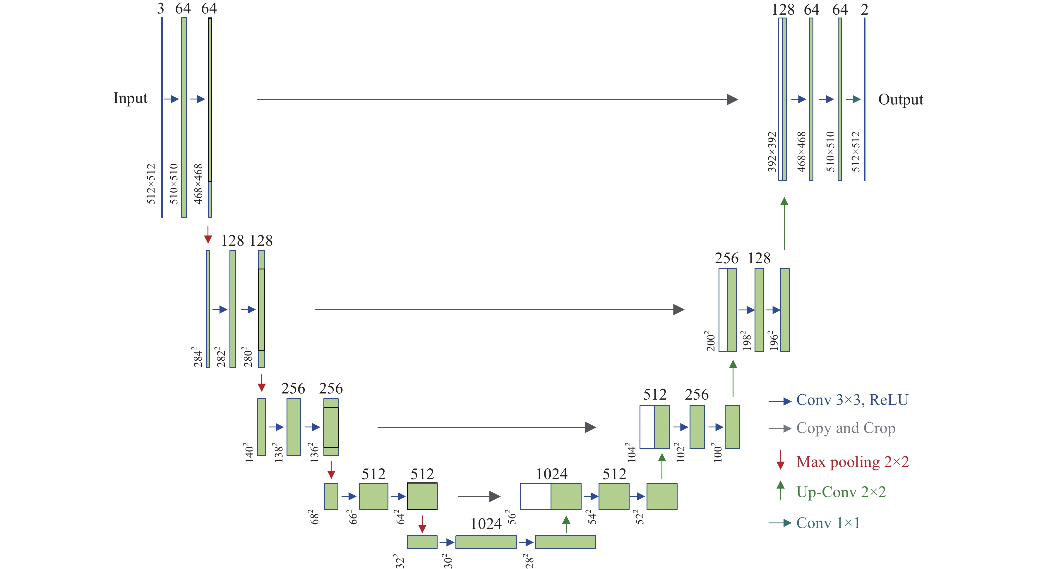
Figure 8.
Structure of U-Net. The network has a symmetric structure, the encoder layer achieves feature extraction by continuously deepening and narrowing the feature map, and the decoder layer achieves pixel-by-pixel classification through an inverse process.
-
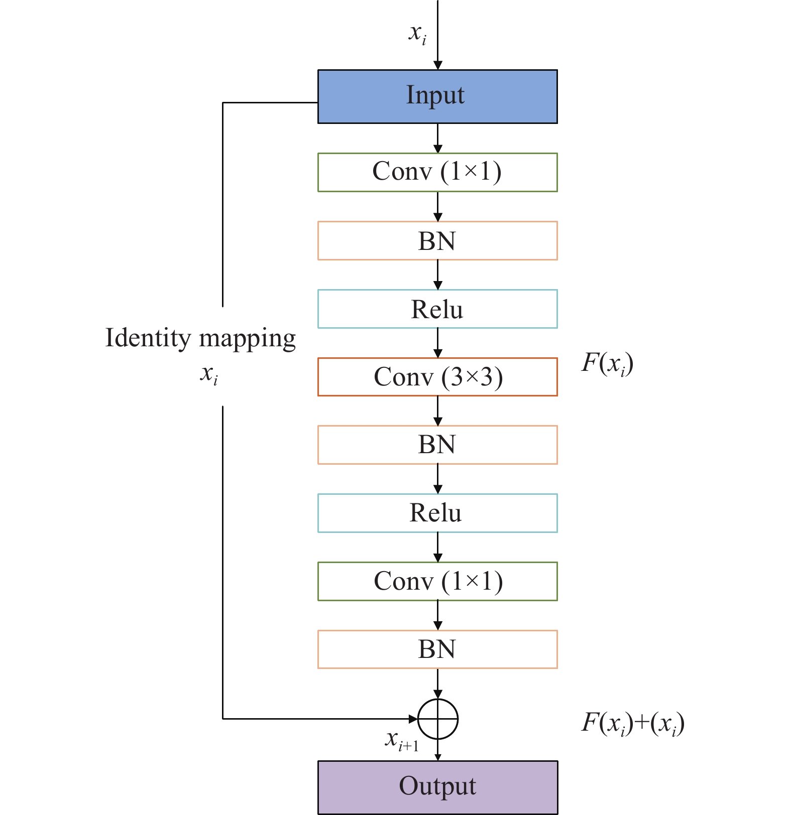
Figure 9.
Structure of residual block. The final output convolved and summed with the original inputs.
-
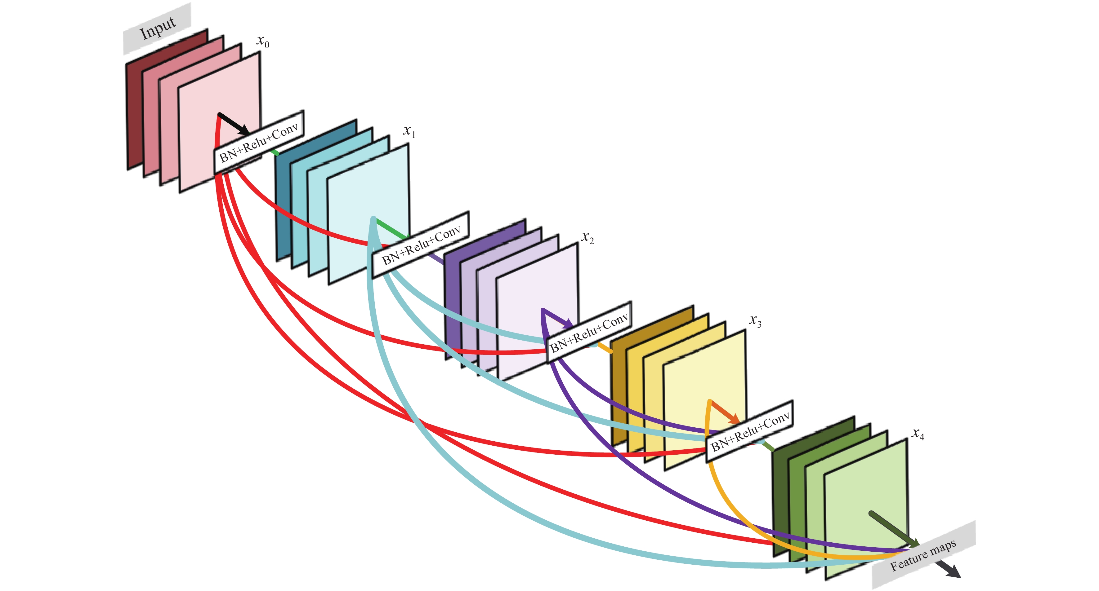
Figure 10.
Structure of DenseNet (modified from (Huang G et al., 2018). The network consists of 5 layers of dense blocks. Each layer takes all preceding feature maps as input.
-
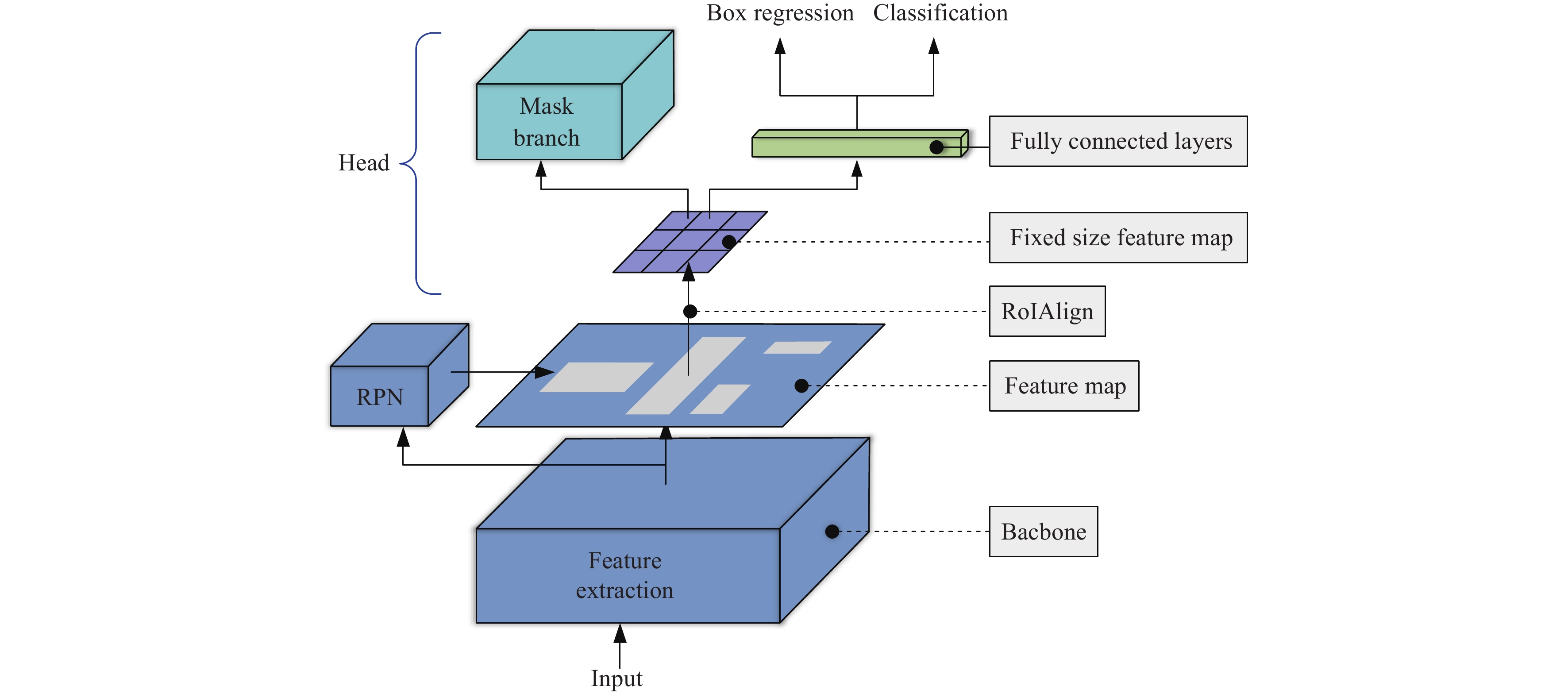
Figure 11.
Structure of Mask R-CNN. The final result has three branches including box location, classification, and semantic segmentation.
-
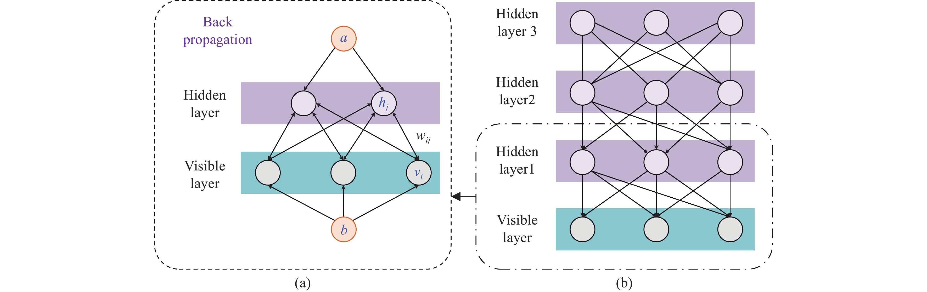
Figure 12.
a‒Structure of restricted Boltzmann machine; b‒Deep belief network, network extracts and reconstructs of input features by stacking multiple RBM.
-
Figure 13.
Structure of Autoencoder, where the encoder projects the high-dimensional inputs into low-dimensional hidden variables thus learning the most features; the decoder restores the hidden variables to the initial dimensions.
-
Figure 14.
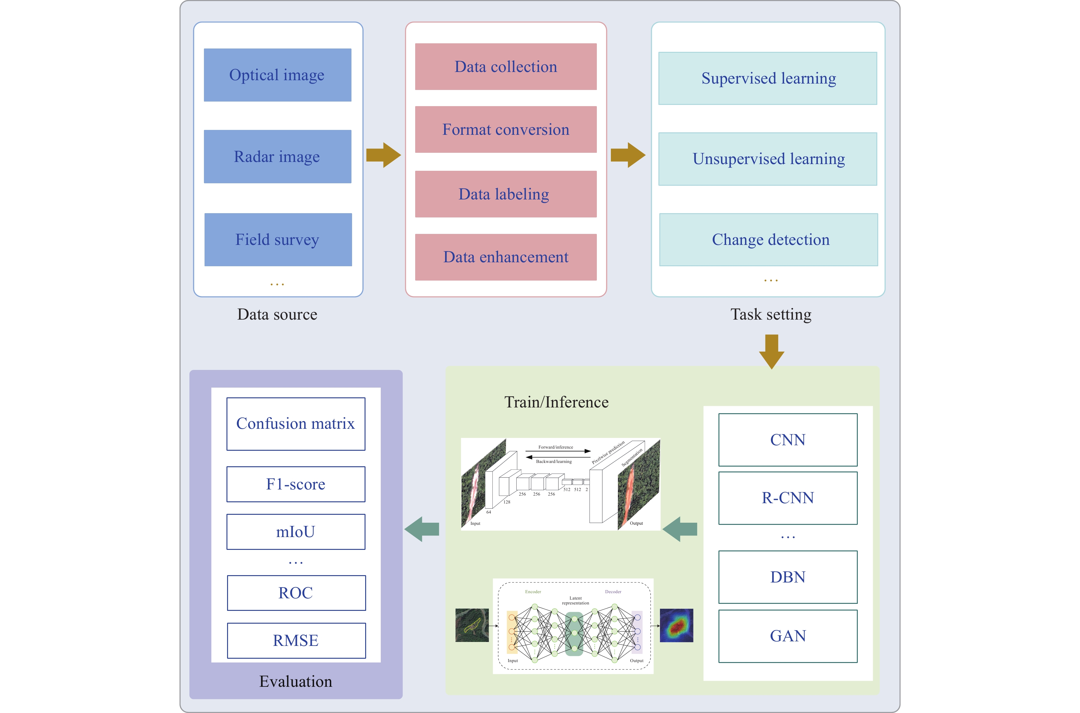
A general workflow of deep learning application for landslide analysis.
-
Figure 15.
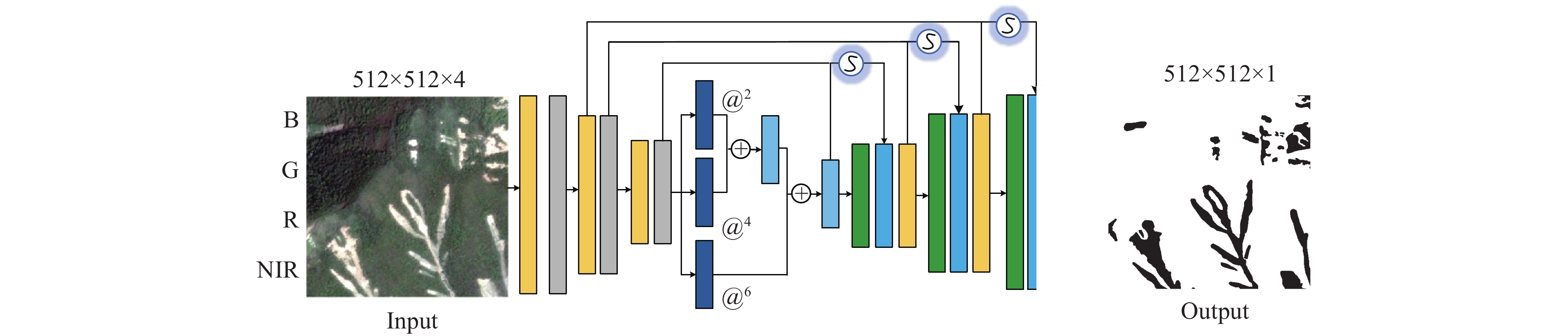
Extraction of landslides in single images based on FCN (modified from Yi YN and Zhang WC, 2020).
-
Figure 16.
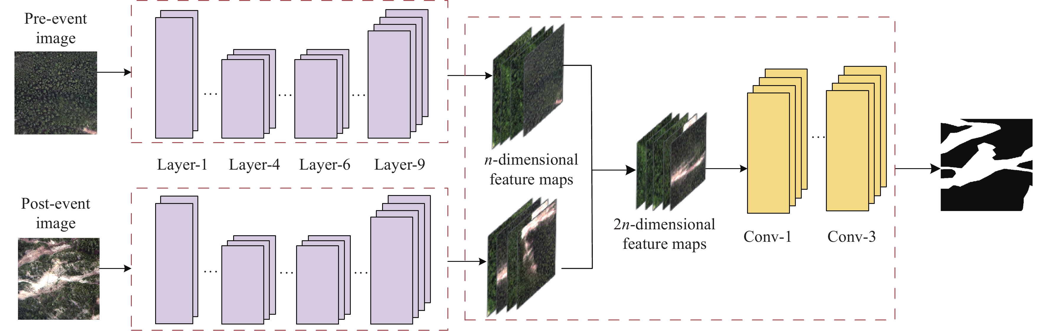
Deep learning-based change detection, the two-branch network learns separate features for the pre-and post-event images, then stacks the two feature maps (modified from Lv et al, 2020).
-
Figure 17.
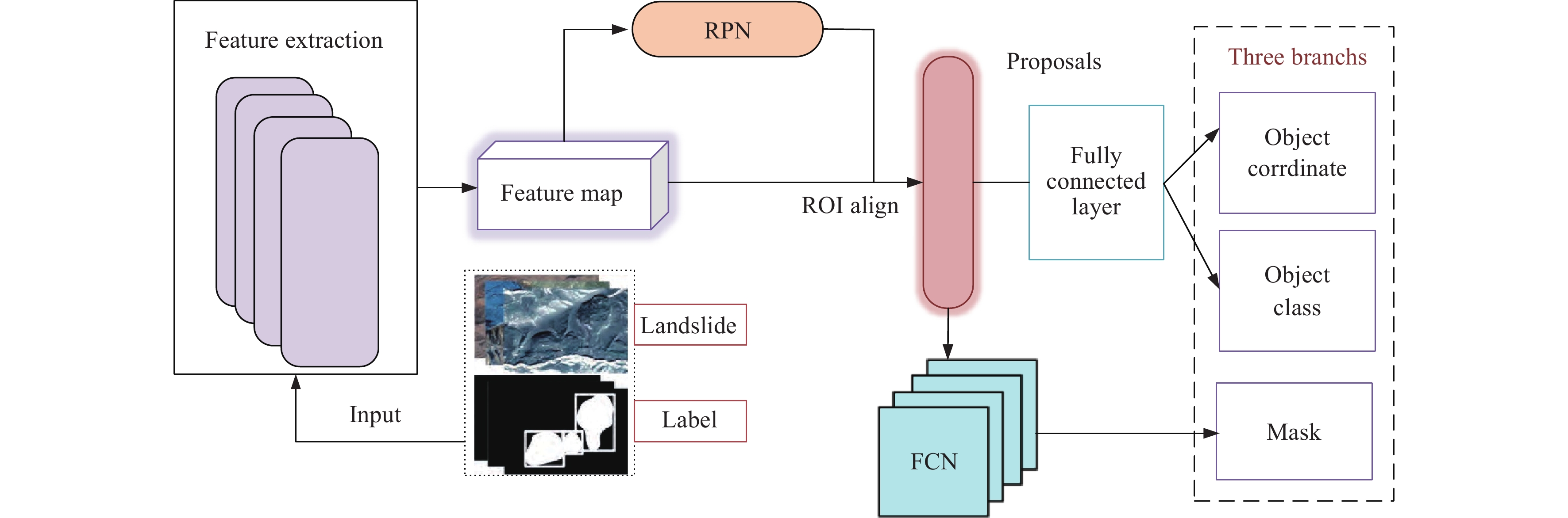
Landslide localization and delineation using Mask R-CNN, the network achieves pixel-by-pixel segmentation by adding a branch to Faster-RCNN (modified from Ullo S et al., 2021).
-
Figure 18.
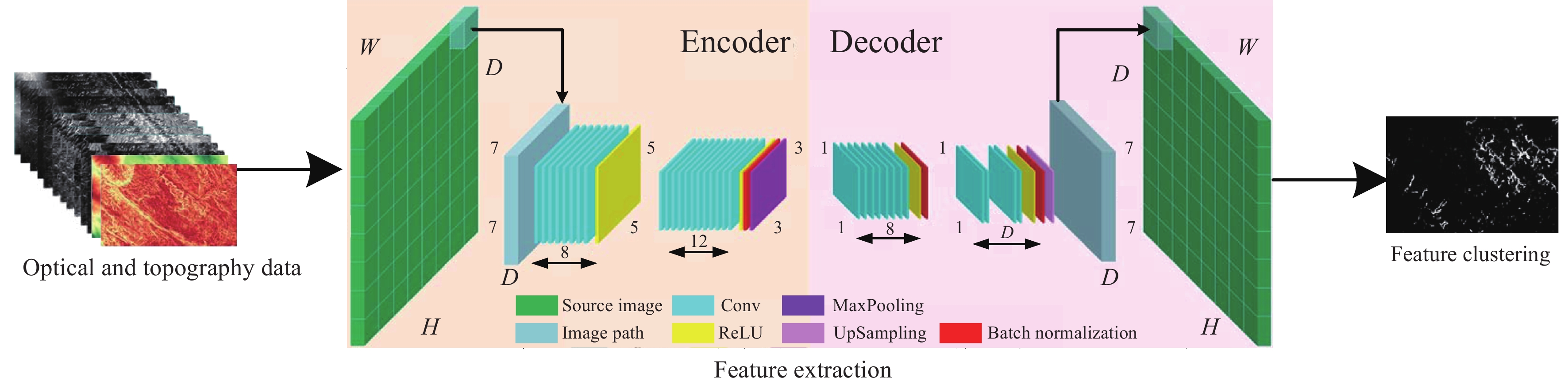
A general framework of landslide mapping based on unsupervised learning, essentially a process of feature extraction and clustering without the participation of labels (modified from Shahabi H et al., 2021).
-
Figure 19.
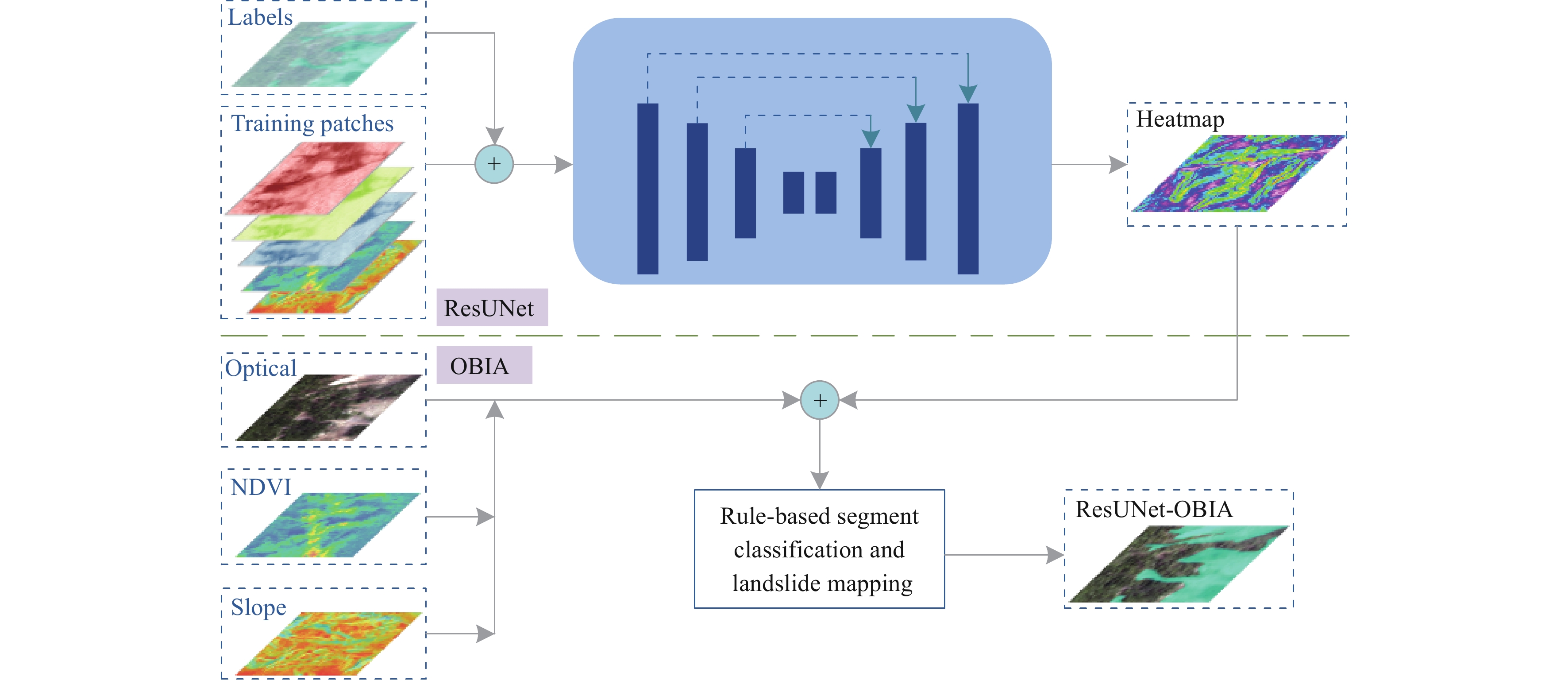
Landslide mapping combing the OBIA and FCN, the final result fused with the outputs of two independent models (modified from Ghorbanzadeh O et al., 2022).