

| Citation: |
Guan-hua Zhao, Heng-xing Lan, Hui-yong Yin, Lang-ping Li, Alexander Strom, Wei-feng Sun, Chao-yang Tian, 2024. Deformation, structure and potential hazard of a landslide based on InSAR in Banbar county, Xizang, China Geology, 7, 203-221. doi: 10.31035/cg2023130

|
Deformation, structure and potential hazard of a landslide based on InSAR in Banbar county, Xizang
-
Abstract
The Xizang Plateau is characterized by complex geological conditions and a relatively fragile ecological environment. In recent years, there has been continuous development and increased human activity in the Xizang Plateau region, leading to a rising risk of landslides. The landslide in Banbar County, Xizang, have been perturbed by ongoing disturbances from human engineering activities, making it susceptible to instability and displaying distinct features. In this study, small baseline subset synthetic aperture radar interferometry (SBAS-InSAR) technology is used to obtain the Line of Sight (LOS) deformation velocity field in the study area, and then the slope-orientation deformation field of the landslide is obtained according to the spatial geometric relationship between the satellite’s LOS direction and the landslide. Subsequently, the landslide thickness is inverted by applying the mass conservation criterion. The results show that the movement area of the landslide is about 6.57×10⁴ m2, and the landslide volume is about 1.45×10⁶ m3. The maximum estimated thickness and average thickness of the landslide are 39 m and 22 m, respectively. The thickness estimation results align with the findings from on-site investigation, indicating the applicability of this method to large-scale earth slides. The deformation rate of the landslide exhibits a notable correlation with temperature variations, with rainfall playing a supportive role in the deformation process and displaying a certain lag. Human activities exert the most substantial influence on the spatial heterogeneity of landslide deformation, leading to the direct impact of several prominent deformation areas due to human interventions. Simultaneously, utilizing the long short-term memory (LSTM) model to predict landslide displacement, and the forecast results demonstrate the effectiveness of the LSTM model in predicting landslides that are in a continuous development and movement phase. The landslide is still active, and based on the spatial heterogeneity of landslide deformation, new recommendations have been proposed for the future management of the landslide in order to mitigate potential hazards associated with landslide instability.
-
Keywords:
- Landslide /
- Human activity /
- InSAR /
- Deformation /
- LSTM model /
- Engineering construction /
- Structure /
- Neural network /
- Thickness /
- Machine learning /
- Prediction and prevention /
- Xizang Plateau
-

-
References
Aryal A, Brooks BA, Reid ME. 2015. Landslide subsurface slip geometry inferred from 3-D surface displacement fields. Geophysical Research Letters, 42(5), 1411–1417. doi: 10.1002/2014gl062688. BISHOP KM. 1999. Determination of Translational Landslide Slip Surface Depth Using Balanced Cross Sections. Environmental & Engineering Geoscience, 5(2), 147–156. doi: 10.2113/gseegeosci.V.2.147. Bichler A, Bobrowsky P, Best M, Douma M, Hunter J, Calvert T, Burns R. 2004. Three-dimensional mapping of a landslide using a multi-geophysical approach: the Quesnel Forks landslide. Landslides, 1(1), 29–40. doi: 10.1007/s10346-003-0008-7. Booth AM, Lamb MP. Avouac JP, Delacourt C. 2013. Landslide velocity, thickness, and rheology from remote sensing: La Clapière landslide, France. Geophysical Research Letters, 40(16), 4299–4304. doi: 10.1002/grl.50828. Booth AM, Roering JJ, Rempel AW. 2013. Topographic signatures and a general transport law for deep-seated landslides in a landscape evolution model(Article). Journal of Geophysical Research:Earth Surface, 118(2), 603–624. doi: 10.1002/jgrf.20051. Barnhart WD, Yeck WL, McNamara DE. 2018. Induced earthquake and liquefaction hazards in Oklahoma, USA: Constraints from InSAR. Remote Sensing of Environment, 218(0), 1–12. doi: 10.1016/j.rse.2018.09.005. Coe JA, Ellis WL, Godt JW, Savage WZ, Savage JE, Michael JA, Kibler JD, Powers PS, Lidke DJ, Debray S. 2003. Seasonal movement of the Slumgullion landslide determined from Global Positioning System surveys and field instrumentation, July 1998–March 2002. Engineering Geology, 68(1–2), 67. doi: 10.1016/s0013-7952(02)00199-0 CVX Research, Inc. 2013, CVX: Matlab software for disciplined convex programming, version 2.0 beta., edited. Cigna F, Bateson LB, Jordan CJ, Dashwood C. 2014. Simulating SAR geometric distortions and predicting Persistent Scatterer densities for ERS-1/2 and ENVISAT C-band SAR and InSAR applications: nationwide feasibility assessment to monitor the landmass of Great Britain with SAR imagery. Remote Sensing of Environment, 152, 441–466. doi: 10.1016/j.rse.2014.06.025. Chen XZ, Cui YF. 2017. The formation of the Wulipo landslide and the resulting debris flow in Dujiangyan City, China. Journal of Mountain Science, 14(6), 1100–1112. doi: 10.1007/s11629-017-4392-1. Cao YM, Guo W, Wu YM, Li LP, Zhang YX, Lan HX. 2022. An hourly shallow landslide warning model developed by combining automatic landslide spatial susceptibility and temporal rainfall threshold predictions. Journal of Mountain Science, 19(12), 3370–3387. doi: 10.1007/s11629-022-7370-1. De Zan F, Guarnieri AM. 2006. TOPSAR: Terrain observation by progressive scans(Article). IEEE Transactions on Geoscience and Remote Sensing, 44(9), 2352–2360. doi: 10.1109/tgrs.2006.873853. Delacourt C, Allemand P, Berthier E, Raucoules D, Casson B, Grandjean P, Pambrun C, Varel E. 2007. Remote-sensing techniques for analysing landslide kinematics: a review. Bulletin de la Société Géologique de France, 178(2), 89–100. doi: 10.2113/gssgfbull.178.2.89. Dai KR, Zhang LL, Song C, Li ZH, Zhuo GC, Xu Q. 2021. Quantitative analysis of Sentinel-1 imagery geometric distortion and their suitability along Sichuan-Xizang Railway. Geomatics and Information Science of Wuhan University, 46(10), 1450–1460. doi: 10.13203/j.whugis20210130. Esposito C, Natale A, Palmese G, Berardino P, Perna S. 2019. Geometric distortions in FMCW SAR images due to inaccurate knowledge of electronic radar parameters: analysis and correction by means of corner reflectors. Remote Sensing of Environment, 232, 111289. doi: 10.1016/j.rse.2019.111289. Feigl KL, Dupré E. 1999. RNGCHN: a program to calculate displacement componenets from dislocations in an elastic half-space with applications for modeling geodetic measurements of crustal deformation. Computers & Geosciences, 25(6), 695–704. doi: 10.1016/s0098-3004(99)00003-5. Farinotti D, Huss M, Bauder A, Funk M, Truffer M. 2009. A method to estimate the ice volume and ice-thickness distribution of alpine glaciers. Journal of Glaciology, 55(191), 422–430. doi: 10.3189/002214309788816759. Fan XM, Xu Q, Scaring, G, Dai LX, Li WL, Dong XJ, Zhu X, Pei XJ, Dai KR, Havenith HB. 2017. Failure mechanism and kinematics of the deadly June 24th 2017 Xinmo landslide, Maoxian, Sichuan, China. Landslides, 14(6), 2129–2146. doi: 10.1007/s10346-017-0907-7. Feng WK, Yi XY, Ge H, Wang Q, Li ZG, Zhan GX. 2017. In-situ borehole shear tests on cataclastic rock mass of Daguangbao landslide(Article). Yantu Gongcheng Xuebao/Chinese Journal of Geotechnical Engineering, 39(9), 1718–1723. doi: 10.11779/cjge201709021. Froude MJ, Petley DN. 2018. Global fatal landslide occurrence from 2004 to 2016(Article). Natural Hazards and Earth System Sciences, 18(8), 2161–2181. doi: 10.5194/nhess-18-2161-2018. Fan XM, Xu Q, Alonso-Rodriguez A, Subramanian SS, Li WL, Zheng G, Dong XJ, Huang RQ. 2019. Successive landsliding and damming of the Jinsha River in eastern Xizang, China: prime investigation, early warning, and emergency response. Landslides, 16(5), 1003–1020. doi: 10.1007/s10346-019-01159-x. Ge DQ. 2018. Comprehensive remote sensing applications in early detection, monitoring, and warning of geological disasters. City and Disaster Reduction, 6, 53–60 (in Chinese with English abstract). He KS, Zhang WM, Wang GQ, Jia XT. 2005. Ground penetrating radar application research for dam landslide disasters. Advances in Science and Technology of Water Resources, 2, 36–39 (in Chinese with English abstract). Hu X, Wang T, Pierson TC, Lu Z, Kim J, Cecere TH. 2016. Detecting seasonal landslide movement within the Cascade landslide complex (Washington) using time-series SAR imagery. Remote Sensing of Environment, 187, 49–61. doi: 10.1016/j.rse.2016.10.006. Huang MH, Fielding EJ, Liang C, Milillo P, Bekaert D, Dreger D, Salzer J. 2017. Coseismic deformation and triggered landslides of the 2016 Mw 6. 2 Amatrice earthquake in Italy. Geophysical Research Letters, 44(3), 1266–1274. doi: 10.1002/2016gl071687. Hu X, Lu Z, Pierson T, Kramer R, George D. 2018. Combining InSAR and GPS to Determine Transient Movement and Thickness of a Seasonally Active Low-Gradient Translational Landslide. Geophysical Research Letters, 45(3), 1453–1462. doi: 10.1002/2017gl076623. Handwerger AL, Booth AM, Huang MH, Fielding EJ. 2021. Inferring the Subsurface Geometry and Strength of Slow-Moving Landslides Using 3-D Velocity Measurements From the NASA/JPL UAVSAR. Journal of Geophysical Research: Earth Surface, 126(3). doi: 10.1029/2020jf005898 Kovács IP, Bugya T, Czigány S, Defilippi M, Lóczy D, Riccardi P, Ronczyk L, Pasquali P. 2019. How to avoid false interpretations of Sentinel-1A TOPSAR interferometric data in landslide mapping? A case study: recent landslides in Transdanubia, Hungary. Natural Hazards, 96(2), 693. doi: 10.1007/s11069-018-3564-9. Kang Y, Lu Z, Zhao CY, Qu W. 2023. Inferring slip-surface geometry and volume of creeping landslides based on InSAR: A case study in Jinsha River basin. Remote Sensing of Environment, 294, 113620. doi: 10.1016/j.rse.2023.113620. Liao MS, Zhang L, Shi XG. 2017. Methods and Practices of Landslide Deformation Radar Remote Sensing Monitoring. China, Science Press, 186. Lee PQ, Xu L, Clausi DA. 2020. Sentinel-1 additive noise removal from cross-polarization extra-wide TOPSAR with dynamic least-squares. Remote Sensing of Environment, 248, 111982. doi: 10.1016/j.rse.2020.111982. Lan HX, Zhang N, Li LP, Tian NM, Ji YX, Liu SJ, Li G, Tian CY, Wu YM, Yao JM, Peng JB, Zhou CH. 2021. Risk analysis of major engineering geological hazards for Sichuan-Xizang Railway in the phase of feasibility study. Journal of Engineering Geology, 29(2), 0326–16 (in Chinese with English abstract). doi: 10.13544 /j.cnki.jeg.2021-0114 doi: 10.13544/j.cnki.jeg.2021-0114. Lan HX, Tian NM, Li LP, Wu YM, Macciotta R, Clague JJ. 2022. Kinematic-based landslide risk management for the Sichuan-Xizang Grid Interconnection Project (STGIP) in China. Engineering Geology, 308, 106823. doi: 10.1016/j.enggeo.2022.106823. Li LP, Lan HX, Strom A, Macciotta R. 2022. Landslide length, width, and aspect ratio: path-dependent measurement and a revisit of nomenclature. Landslides, 19(12), 3009–3029. doi: 10.1007/s10346-022-01935-2. Morlighem M, Rignot E, Seroussi H, Larour E, Dhia HB, Aubry D. 2011. A mass conservation approach for mapping glacier ice thickness. Geophysical Research Letters, 38(19), 0. doi: 10.1029/2011gl048659. Mirus BB, Becker RE, Baum RL, Smith JB. 2018. Integrating real-time subsurface hydrologic monitoring with empirical rainfall thresholds to improve landslide early warning. Landslides, 15(10), 1909–1919. doi: 10.1007/s10346-018-0995-z. Ma JW, Xia D, Guo HX, Wang YK, Niu XX, Liu ZY, J S. 2022. Metaheuristic-based support vector regression for landslide displacement prediction: a comparative study. Landslides, 19(10), 1–23. doi: 10.1007/s10346-022-01923-6. Nikolaeva E, Walter TR, Shirzaei M, Zschau J. 2014. Landslide observation and volume estimation in central Georgia based on L-band InSAR(Article). Natural Hazards and Earth System Sciences, 14(3), 675–688. doi: 10.5194/nhess-14-675-2014. Qiu HJ, Cui P, Regmi AD, Hu S, Wang XG, Zhang YZ, He Y. 2017. Influence of topography and volume on mobility of loess slides within different slip surfaces. CATENA, 157(2), 180–188. doi: 10.1016/j.catena.2017.05.026. Qi SW, Li YC, Song SH, Lan HX, Ma FS, Li ZQ, Chen XQ, Cui ZD, Zhang LQ, Liu CL, Chen WZ, Zou Y, Tang FJ, Lu X, Guo SF. 2022. Regionalization of engineering geological stability and distribution of engineering disturbance disasters in Xizang Plateau. Journal of Engineering Geology, 30(3), 599–608 (in Chinese with English abstract). doi: 10.13544/j.cnki.jeg.2022-0172. Rasmussen, Lowell A. 1988. Bed topography and mass-balance distribution of Columbia Glacier, Alaska, USA, determined from sequential aerial photography. Journal of Glaciology, 34(117), 208–216. doi: 10.1017/s0022143000032251. Rowan MG, Kligfield R. 1989. Cross section restoration and balancing as aid to seismic interpretation in extensional terranes. AAPG Bulletin, 73(8), 955–966. doi: 10.1306/44b4a2bc-170a-11d7-8645000102c1865d. Raspini F, Bianchini S, Ciampalini A, Soldato MD, Solari L, Novali F, Conte SD, Rucci A, Ferretti A, Casagli N. 2018. Continuous, semi-automatic monitoring of ground deformation using Sentinel-1 satellites. Scientific Reports, 8(1), 7253. doi: 10.1038/s41598-018-25369-w. Sassa K, Yin Y, Canuti P. 2015. The Third World Landslide Forum, Beijing, 2014. Landslides, 12(1), 177–192. doi: 10.1007/s10346-015-0555-8. Sun Q, Hu J, Zhang L, Ding XL. 2016. Towards Slow-Moving Landslide Monitoring by Integrating Multi-Sensor InSAR Time Series Datasets: The Zhouqu Case Study, China. Remote Sensing, 8(11), 908. doi: 10.3390/rs8110908. Sowter A, Bin Che Amat M, Cigna F, Marsh S, Athab A, Alshammari L. 2016. Mexico City land subsidence in 2014–2015 with Sentinel-1 IW TOPS: Results using the Intermittent SBAS (ISBAS) technique. International Journal of Applied Earth Observation and Geoinformation, 52, 230–242. doi: 10.1016/j.jag.2016.06.015. Shi GL, Chen Q, Liu XW, Yang YH, Xu Q, Zhao JJ. 2022. Deformation velocity field along aspect direction of an ancient landslide at Taoping village derived from ascending and descending Sentinel-1A data. Journal of Engineering Geology, 30(4), 1350–1361 (in Chinese with English abstract). Tian NM, Lan HX. 2022. The indispensable role of resilience in rational landslide risk management for social sustainability. Geography and Sustainability, 4(1), 70–83. doi: 10.1016/j.geosus.2022.11.007. Wang SJ. 1997. Interaction between human engineering activity and geoenvironment and its environment effects. Journal of Geological Hazards and Environment Preservation, 8(1), 19–26 (in Chinese with English abstract). Wang SJ. 2002. Coupling of earth’s endogenic and exogenic geological processes and progins on serious geological disasters. Journal of Engineering Geology, 2, 115–117 (in Chinese with English abstract). Xu, Q, Peng DL, Zhang S, Zhu X, He CY, Qi X, Zhao KY, Xiu DH, Ju, NP. 2020. Successful implementations of a real-time and intelligent early warning system for loess landslides on the Heifangtai terrace, China. Engineering Geology, 278(0), 105817. doi: 10.1016/j.enggeo.2020.105817. Yang YF, Zhang ZH, Fu J. 2009. Detection of GPR and determination of district and depth on landslide area. Journal of Zhejiang Sci-Tech University, 3, 395–398 (in Chinese with English abstract). Yin YP, Wang HD, Gao YL, Li XC. 2010. Real-time monitoring and early warning of landslides at relocated Wushan Town, the Three Gorges Reservoir, China. Landslides, 7(3), 339–349. doi: 10.1007/s10346-010-0220-1. Yang G, Shu ZP, Zhang J, Deng R. 2021. Development features and disaster prevention study of a landslide in Bianba County, Changdu City, Xizang. Resource Information and Engineering, 36(No.5), 118–122 (in Chinese with English abstract). doi: 10.19534/j.cnki.zyxxygc.2021.05.034. Yao JM, Lan HX, Li LP, Cao YM, Wu YM, Zhang YX, Zhou CD. 2022. Characteristics of a rapid landsliding area along Jinsha River revealed by multi-temporal remote sensing and its risks to Sichuan-Xizang railway. Landslides, 19(3), 703–718. doi: 10.1007/s10346-021-01790-7. Yang C, Yang YH, Wang JY, Xu Q, Chen Q, Tao XX, Hu ZQ. 2023. Inferring landslide depth based on ascending and descending InSAR deformations-example of Taoping village ancient landslide. Journal of Engineering Geology, 31(3), 868–879 (in Chinese with English abstract). doi: 10.13544/j.cnki.jeg.2021-0172. Zhang T, Fang XM, Song CH, Appel E, Wang YD. 2014. Cenozoic tectonic deformation and uplift of the South Tian Shan: Implications from magnetostratigraphy and balanced cross-section restoration of the Kuqa depression. Tectonophysics, 628, 172–187. doi: 10.1016/j.tecto.2014.04.044. Zhou L, Guo JM, Hu JY, Li JW, Xu YF, Pan YJ, Shi M. 2017. Wuhan Surface Subsidence Analysis in 2015–2016 Based on Sentinel-1A Data by SBAS-InSAR. Remote Sensing, 9(10), 982. doi: 10.3390/rs9100982. Zhao CY, Lu Z. 2018. Remote Sensing of Landslides—A Review. Remote Sensing, 10(2), 279. doi: 10.3390/rs10020279. Zhu Q, Zeng HW, Ding YL, Xie X, Liu F, Zhang LG, Li HF, Hu H, Zhang JX, Chen L, Chen L, Zhang PC, He HG. 2019. A review of major potential landslide hazards analysis. Acta Geodaetica et Cartograpgica Sinica, 48(12), 1551–1561. doi: 10.11947/j.AGCS.2019.20190452. Zhang YS, Liu XY, Yao X. 2020. InSAR-based method for early recognition of ancient landslide reactivation in Dadu River, China. Journal of Hydraulic Engineering, 51(5), (in Chinese with English abstract). doi: 10.13243/j.cnki.slxb.20200034 Zhang L, Shi B, Zhu HH, Han HM, Fan XD. 2021. PSO-SVM-based deep displacement prediction of Majiagou landslide considering the deformation hysteresis effect. Landslides, 18(1), 179–193. doi: 10.1007/s10346-020-01426-2. Zhao Z, Chen JH, Xu KH, Xie HW, Gan XX, Xu H. 2021. A spatial case-based reasoning method for regional landslide risk assessment. International Journal of Applied Earth Observation and Geoinformation, 102, 102381. doi: 10.1016/j.jag.2021.102381. Zhang FY, Peng JB, Huang XW, Lan HX. 2021. Hazard assessment and mitigation of non-seismically fatal landslides in China. Natural Hazards, 106(1), 785–804. doi: 10.1007/s11069-020-04491-x. Zhu W, Yang LY, Zhang JM, Li ZH, Xu XY. 2023. Thickness estimation of Xiongba landslide in Gongjue area of Xizang, China by combining InSAR and mass conservation method. Journal of Earth Sciences and Environment, 45(3), 535–547 (in Chinese with English abstract). doi: 10.19814/j.jese.2022.12081. Zhao Z, Chen JH, Yao JM, Xu KH, Liao YY, Xie HW, Gan XX. 2023a. An improved spatial case-based reasoning considering multiple spatial drivers of geographic events and its application in landslide susceptibility mapping. Catena, 223, 106940. doi: 10.1016/j.catena.2023.106940. Zhao Z, Chen JH. 2023b. A robust discretization method of factor screening for landslide susceptibility mapping using convolution neural network, random forest, and logistic regression models. International Journal of Digital Earth, 16(1), 408–429. doi: 10.1080/17538947.2023.2174192. Zhao Z, Lan HX, Li LP, Strom A. 2024. Landslide spatial prediction using cluster analysis. Gondwana Research. 130, 291– 307. doi: 10.1016/j.gr.2024.02.006 -
Access History

Figures(16)
Tables(1)

Export File
Citation
Guan-hua Zhao, Heng-xing Lan, Hui-yong Yin, Lang-ping Li, Alexander Strom, Wei-feng Sun, Chao-yang Tian, 2024. Deformation, structure and potential hazard of a landslide based on InSAR in Banbar county, Xizang, China Geology, 7, 203-221. doi: 10.31035/cg2023130
Format
Content
 DownLoad:


-
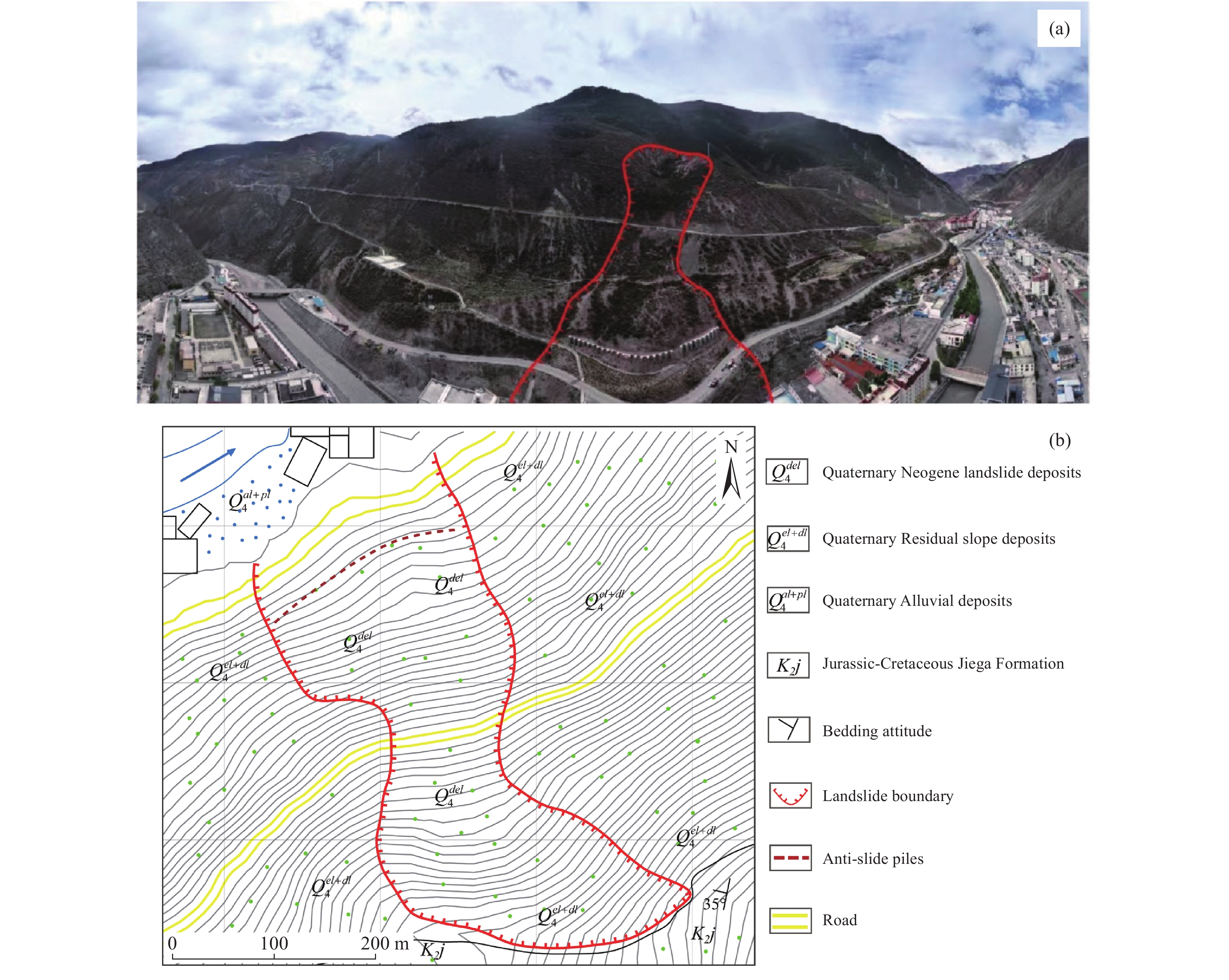
Figure 1.
Banbar landslide.
-
Figure 2.
a-Aerial wide-angle photo of the landslide in Banbar County captured by UAV. b-Engineering geological plan of the landslide.
-
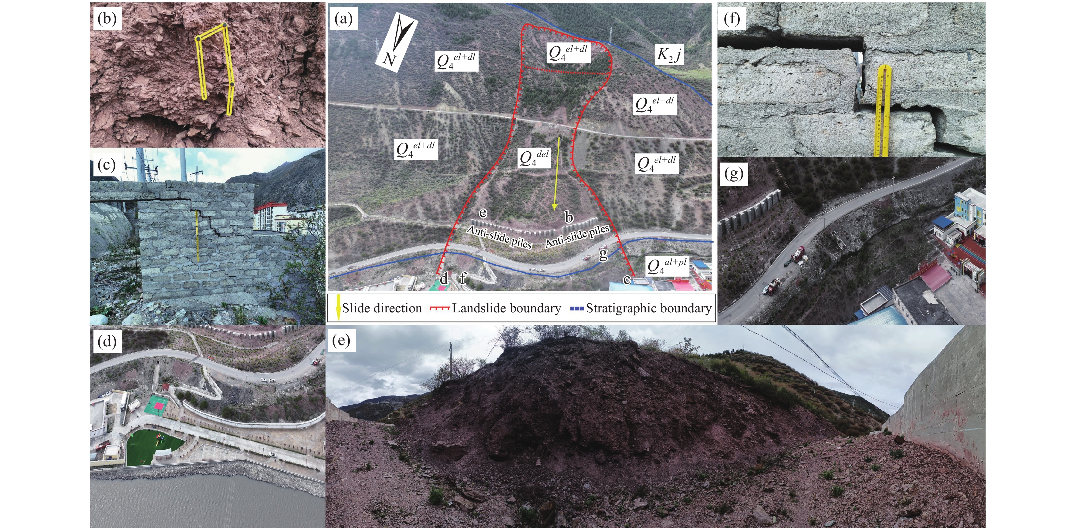
Figure 3.
Photos of Banbar landslide. a-Overview of the study area captured by UAV and the specific locations of b, c, d, e, f, and g have been marked. d-The east side of the front portion of the landslide captured by UAV. g-The west side of the front portion of the landslide captured by UAV. c, f-The cracking in houses near the front portion of the landslide. b, e-The loose gravel soil behind the anti-slide piles.
-
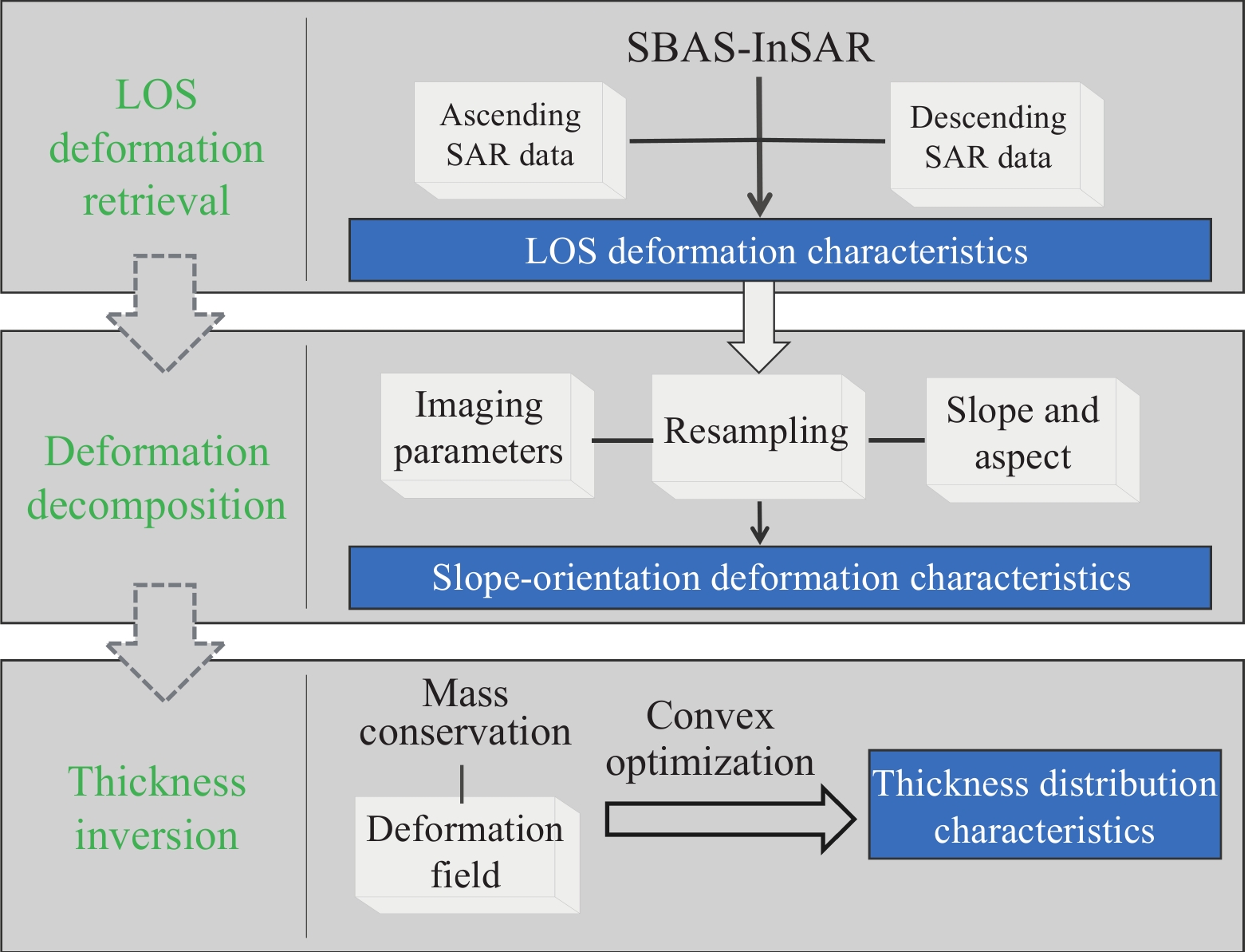
Figure 4.
Flowchart showing available data and methods used in this study.
-
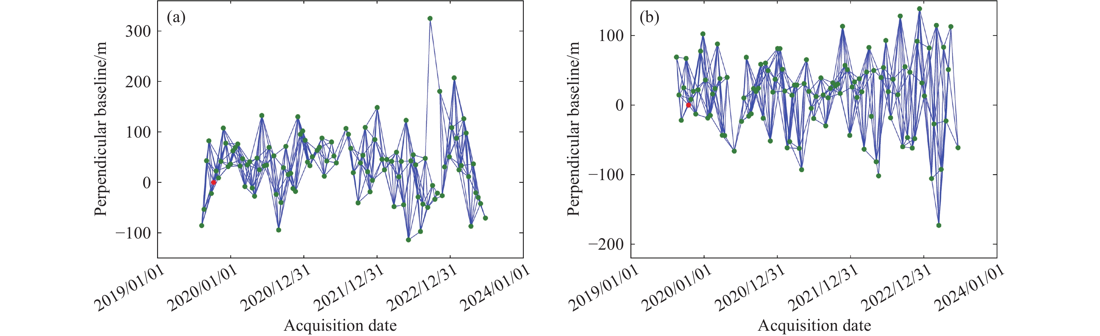
Figure 5.
Spatial and temporal baselines of the interferograms. a-Ascending data. b-Descending data. The red dots represent master images.
-
Figure 6.
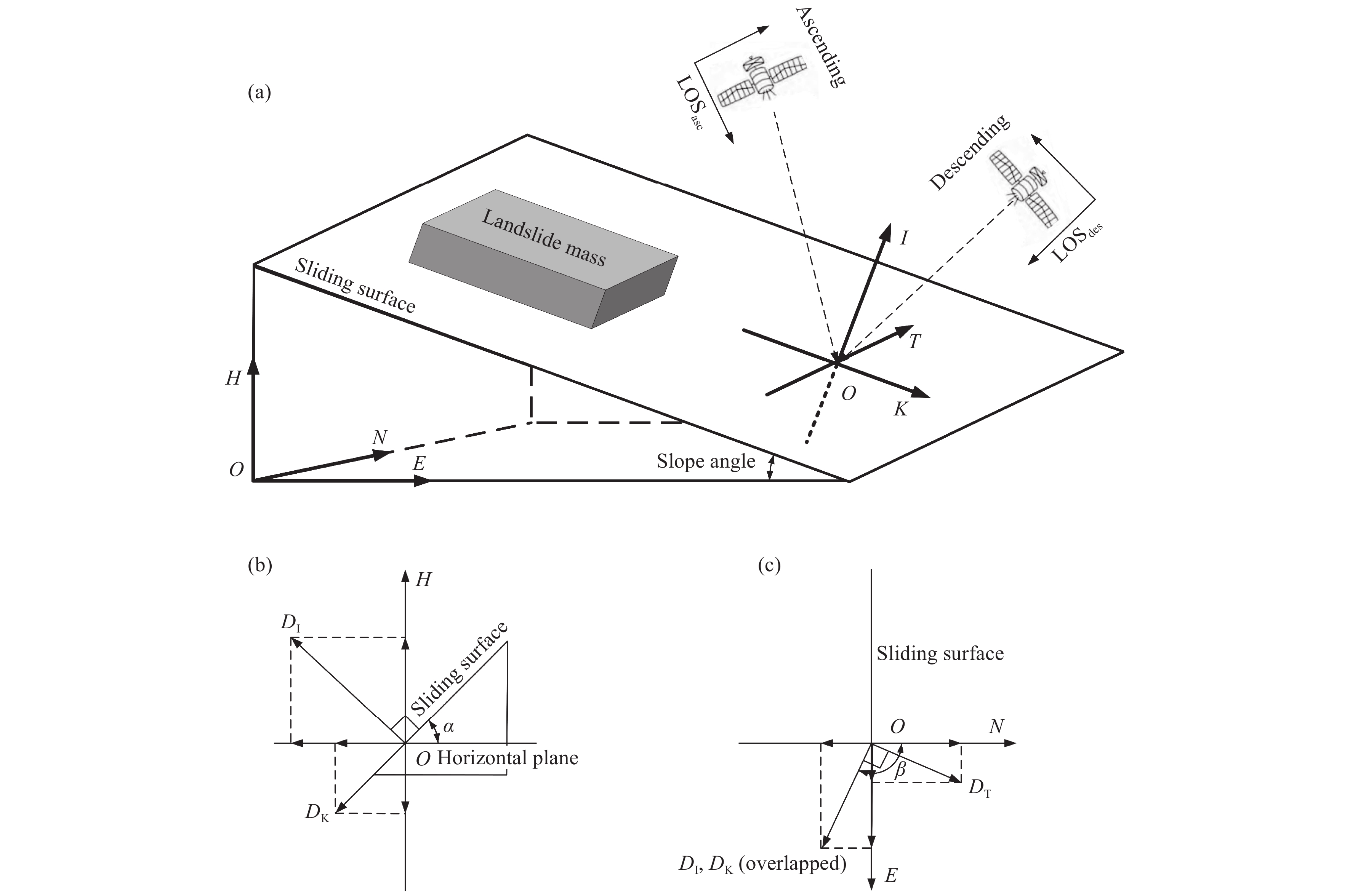
Landslide deformation decomposition. a-The coordinate system of the sliding surface of landslide, where ON represents North-South, OE represents East-West, OH represents Vertical. And on the sliding surface, OI represents normal, OT represents perpendicular and OK represents average aspect. b, c-The geometric relationship between the sliding surface and “North-East-High” coordinate system.
-
Figure 7.
Deformation velocity fields along the LOS. a-Ascending orbit of the landslide area. b-Descending orbit of the landslide area. ⅰ and ⅱ are areas with higher deformation velocity.
-
Figure 8.
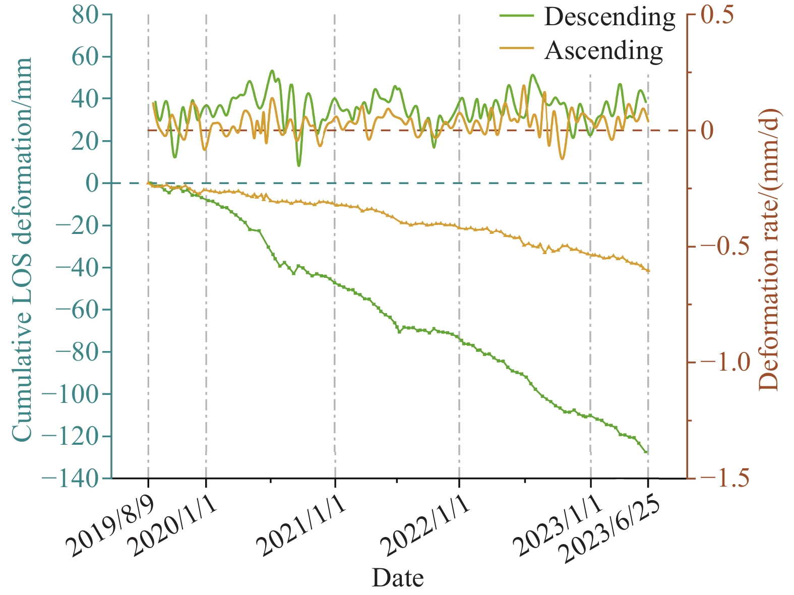
Cumulative LOS deformation and deformation rates. The green dashed and solid lines represent the cumulative deformation value and deformation rate of the maximum deformation point in the descending orbit result, respectively. The yellow dashed and solid lines represent the cumulative deformation value and deformation rate of the maximum deformation point in the ascending orbit result.
-
Figure 9.
The slope-orientation deformation velocity fields of the landslide. a-Slope normal direction. b-Slope direction. A and B are high deformation velocity areas with opposite directions. C is area with higher deformation velocity.
-
Figure 10.
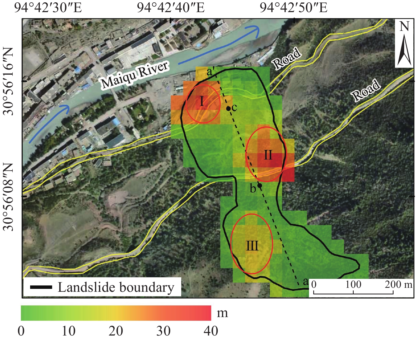
Thickness distribution of landslide. I, II, and III are areas with relatively high prediction thickness values.
-
Figure 11.
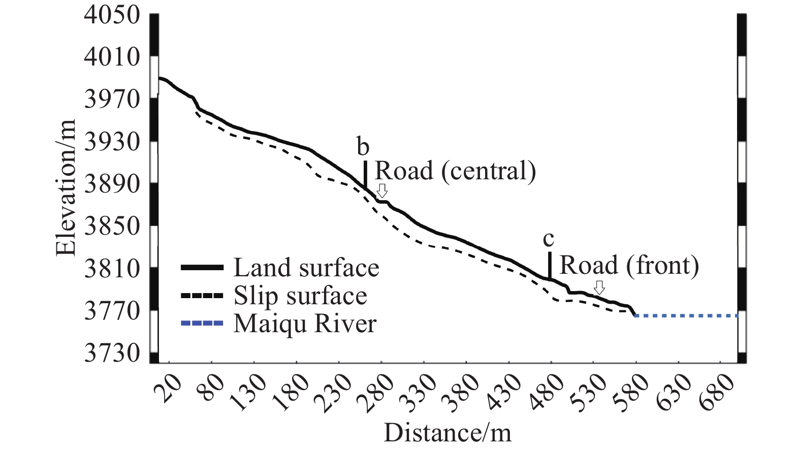
Distribution of landslide thickness along profile aa'. b and c are monitoring points for deep-seated displacement (the actual values of landslide thickness at points b and c are known).
-
Figure 12.
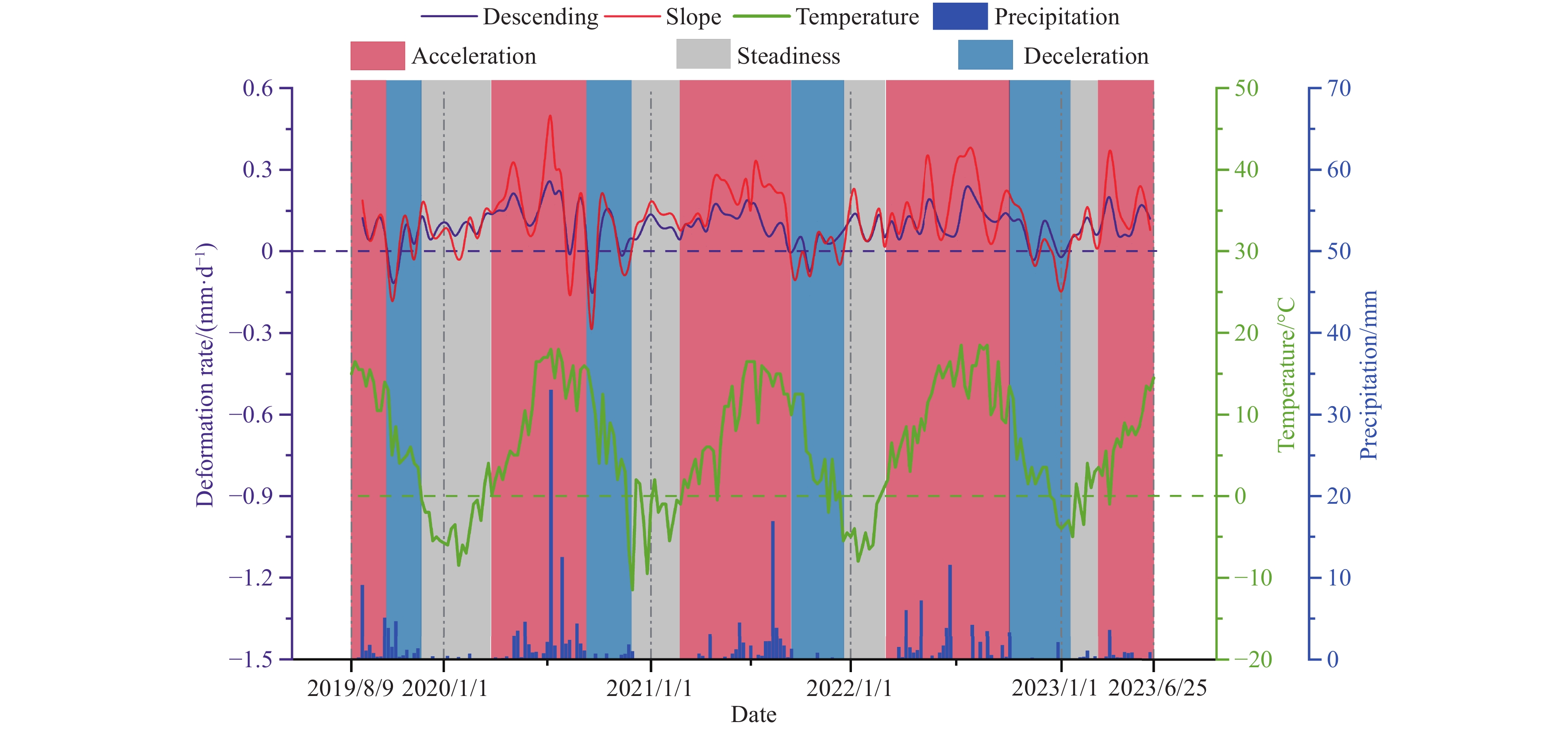
Constraints data of landslide. The red curve and the purple curve respectively represent the deformation rate of the maximum deformation point in the slope deformation result and the deformation rate of the maximum deformation point in the descending orbit result. The dark green dashed line represents temperature, and the blue bar graph represents precipitation.
-
Figure 13.
Spatial heterogeneity of landslide deformation velocity fields. a-Slope normal direction. b-Slope direction. c-Overview of study area captured by UAV. The red dashed lines in (c) correspond to area Ⅰ, area Ⅱ, and area Ⅲ in Fig. 10. The blue shaded area corresponds to regions with higher velocity of deformation in a, b.
-
Figure 14.
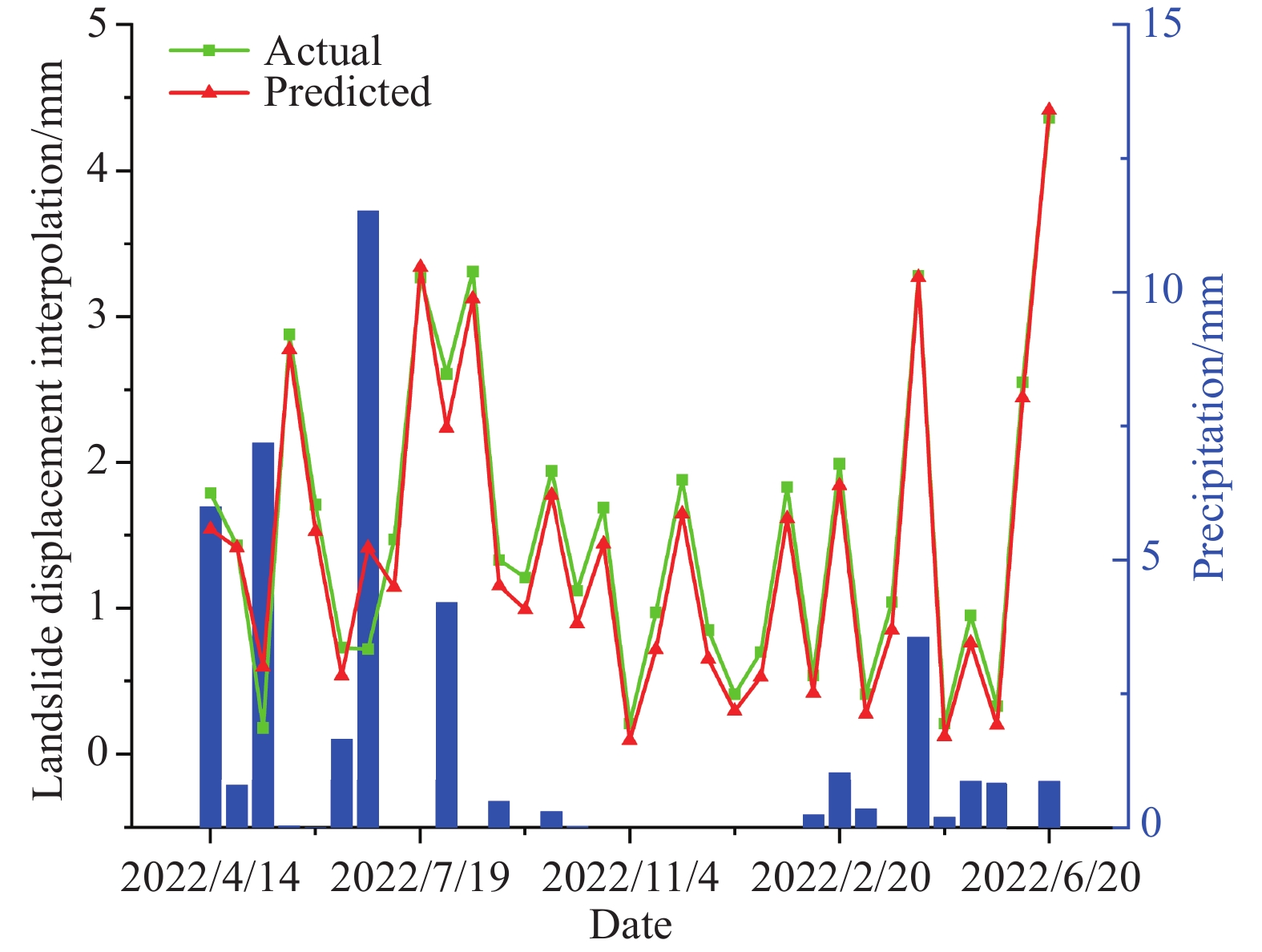
Displacement prediction results based on daily precipitation data and displacement interpolation data from the maximum deformation point in the descending orbit. The green dotted line represents the actual values, the red dotted line represents the predicted values, and the blue bar graph represents the precipitation.
-
Figure 15.
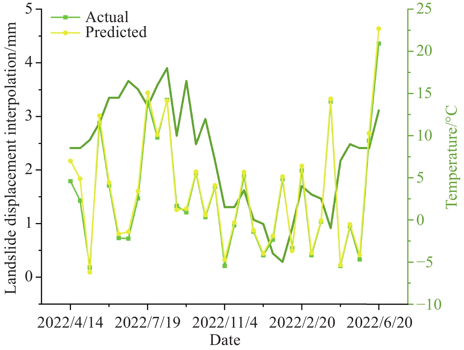
Displacement prediction results based on daily temperature data and displacement interpolation data from the maximum deformation point in the descending orbit. The green dotted line represents the actual values, the yellow dotted line represents the predicted values, and the dark green dashed line represents the temperature.
-
Figure 16.
Suggestion sites for anti-slide piles installation. Ⅰ, Ⅱ, and Ⅲ correspond to area Ⅰ, area Ⅱ, and area Ⅲ in the thickness prediction result (Fig. 10).