
| Citation: |
Lu-ning Shang, Pan-feng Li, Run-lin Du, Feng-long Bai, Gang Hu, Wen-chao Lü, Xia Li, Xi Mei, Tian-yu Zhang, Hou-zhen Cao, Jing-yi Cong, Xian-yao Shi, 2021. Structural characteristics of the KPR-CBR triple-junction inferred from gravity and magnetic interpretations, Philippine Sea Plate, China Geology, 4, 541-552. doi: 10.31035/cg2021089

|
Structural characteristics of the KPR-CBR triple-junction inferred from gravity and magnetic interpretations, Philippine Sea Plate
-
Abstract
The intersection of the Kyushu-Palau Ridge (KPR) and the Central Basin Rift (CBR) of the West Philippine Basin (WPB) is a relic of a trench-trench-rift (TTR) type triple-junction, which preserves some pivotal information on the cessation of the seafloor spreading of the WPB, the emplacement and disintegration of the proto-Izu-Bonin-Mariana (IBM) Arc, and the transition from initial rifting to steady-state spreading of the Parece Vela Basin (PVB). However, the structural characteristics of this triple-junction have not been thoroughly understood. In this paper, using the newly acquired multi-beam bathymetric, gravity, and magnetic data obtained by the Qingdao Institute of Marine Geology, China Geological Survey, the authors depict the topographic, gravity, and magnetic characteristics of the triple-junction and adjacent region. Calculations including the upward continuations and total horizontal derivatives of gravity anomaly are also performed to highlight the major structural features and discontinuities. Based on these works, the morphological and structural features and their formation mechanisms are analyzed. The results show that the last episode amagmatic extension along the CBR led to the formation of a deep rift valley, which extends eastward and incised the KPR. The morphological and structural fabrics of the KPR near and to the south of the triple-junction are consistent with those of the western PVB, manifesting as a series of NNE-SSW- and N-S-trending ridges and troughs, which were produced by the extensional faults associated with the initial rifting of the PVB. The superposition of the above two reasons induced the prominent discontinuity of the KPR in deep and shallow crustal structures between 15°N‒15°30′N and 13°30′N‒14°N. Combined with previous authors’ results, we propose that the stress produced by the early spreading of the PVB transmitted westward and promoted the final stage amagmatic extension of the CBR. The eastward propagation of the CBR destroyed the KPR, of which the magmatism had decayed or ceased at that time. The destruction mechanism of the KPR associated with the rifting of the PVB varies along strike the KPR. Adjacent to the triple-junction, the KPR was destroyed mainly due to the oblique intersection of the PVB rifting center. Whereas south of the triple-junction, the KPR was destroyed by the E-W-directional extensional faulting on its whole width.
-

-
References
Deschamps A, Lallemand S, Dominguez S. 1999. The last spreading episode of the West Philippine Basin revisited. Geophysical Research Letters, 26(14), 2073–2076. doi: 10.1029/1999GL900448. Deschamps A, Okino K, Fujioka K. 2002a. Late amagmatic extension along the central and eastern segments of the West Philippine Basin fossil spreading axis. Earth and Planetary Science Letters, 203, 277–293. doi: 10.1016/S0012-821X(02)00855-5. Deschamps A, Lallemand S. 2002b. The West Philippine Basin: An Eocene to Early Oligocene back arc basin opened between two opposite subduction zones. Journal of Geophysical Research, 107(B12,2322), 1–24. doi: 10.1029/2001JB001706. Hilde TWC, Lee CS. 1984. Origin and evolution of the West Philippine Basin: A new interpretation. Tectonophysics, 102 (1‒4), 85‒104. doi: 10.1016/0040-1951(84)90009-X Ishizuka O, Taylor RN, Yuasa M, Ohara Y. 2011. Making and breaking an island arc: A new perspective from the Oligocene Kyushu-Palau arc, Philippine Sea. Geochemistry, Geophysics, Geosystems, 12 (5), 1‒40. doi: 10.1029/2010GC003440 Lallemand S. 2016. Philippine Sea inception, evolution, and consumption with special emphasis on the early stages of Izu-Bonin-Mariana subduction. Progress in Earth and Planetary Science, 2016, 3(5), 1–26. doi: 10.1186/s40645-016-0085-6. Nishizawa A, Kaneda K, Oikawa M. 2016. Crust and uppermost mantle structure of the Kyushu-Palau Ridge, remnant arc on the Philippine Sea Plate. Earth, Planets and Space, 68 (30), 1‒18. doi: 10.1186/s40623-016-0407-3 Okino K, Fujioka K. 2003. The Central basin spreading center in the Philippine Sea: Structural of an extinct spreading center and implications for marginal basin formation. Journal of Geophysical Research, 108(B1,2020), 1–18. doi: 10.1029/2001JB001095. Seton M, Flament N, Whittaker J, Muller RD, Gurnis M. 2015. Ridge subduction sparked reorganization of the Pacific Plate-mantle system 60‒50 million years ago. Geophysical Research Letters, 42, 1732–1740. doi: 10.1002/2015GL063057. Wu J, Suppe J, Lu RQ, Kanda R. 2016. Philippine Sea and East Asian plate tectonics since 52 Ma constrained by new subducted slab reconstruction methods. Journal of Geophysical Research: Solid Earth, 121, 4670–4741. doi: 10.1002/2016JB012923. Yamazaki T, Chiyonobu S, Ishizuka O, Tajima F, Uto N, Takagawa S. 2021. Rotation of the Philippine Sea Plate inferred from paleomagnetism of oriented cores taken with an ROV-based coring apparatus. Earth, Planets and Space, 73 (161), 1‒10. doi: 10.1186/s40623-021-01490-5 Yen HY, Lo YT, Ye YL, Hsieh HH, Chang WY, Chen CH, Chen CR, Shih MH. 2015. The crustal thickness of the Philippine Sea Plate derived from gravitational data. Terrestrial Atmospheric and Oceanic Sciences, 26 (3), 253–259. doi: 10.3319/TAO.2014.11.17.01(T). -
Access History

Figures(7)

Export File
Citation
Lu-ning Shang, Pan-feng Li, Run-lin Du, Feng-long Bai, Gang Hu, Wen-chao Lü, Xia Li, Xi Mei, Tian-yu Zhang, Hou-zhen Cao, Jing-yi Cong, Xian-yao Shi, 2021. Structural characteristics of the KPR-CBR triple-junction inferred from gravity and magnetic interpretations, Philippine Sea Plate, China Geology, 4, 541-552. doi: 10.31035/cg2021089
Format
Content
 DownLoad:

-
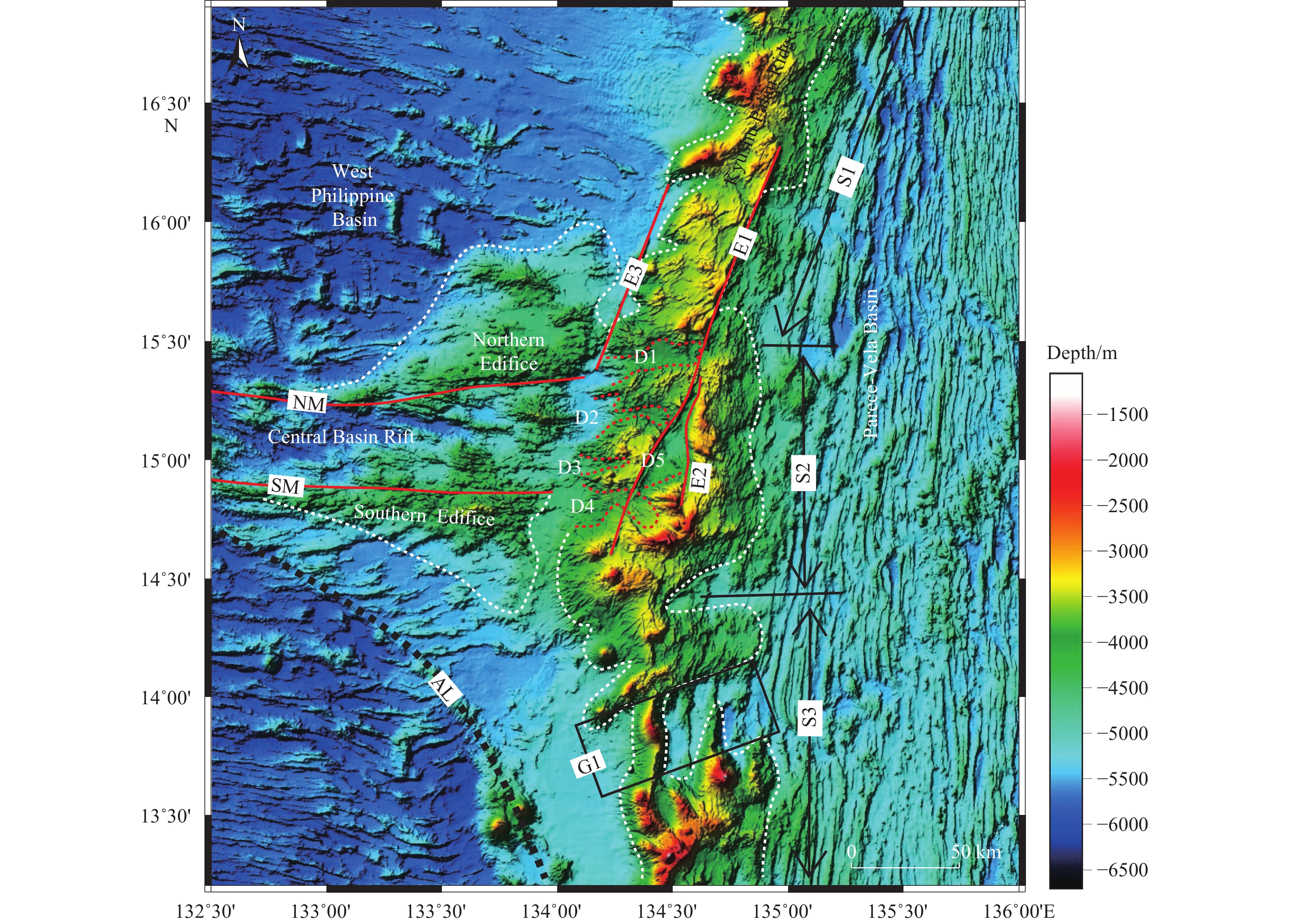
Figure 1.
a‒Topographic features and plate tectonic setting of the Philippine Sea Plate (after Lallemand S, 2016). Active and inactive spreading centers are denoted by solid and dashed red double lines, respectively. Solid red single lines represent main fracture zones. The Kyushu-Palau Ridge is highlighted by the dashed yellow line. b‒present-day relative plate motions across the PSP boundaries calculated from MORVEL (after Wu J et al., 2016). AP‒Amami Plateau; BH‒Bird’s Head minor plate; BR‒Benham Rise; CBR‒Central Basin Rift; DR‒Daito Ridge; GR‒Gagua Ridge; Hal‒Halmahera; HB‒Huatung Basin; LOFZ‒Luzon-Okinawa Fracture Zone; MFZ‒Mindano Fracture Zone; MS‒Molucca Sea minor plate; ODE‒Oki-Daito Escarpment; ODR‒Oki-Daito Ridge; UR‒Urdaneta Rise.
-
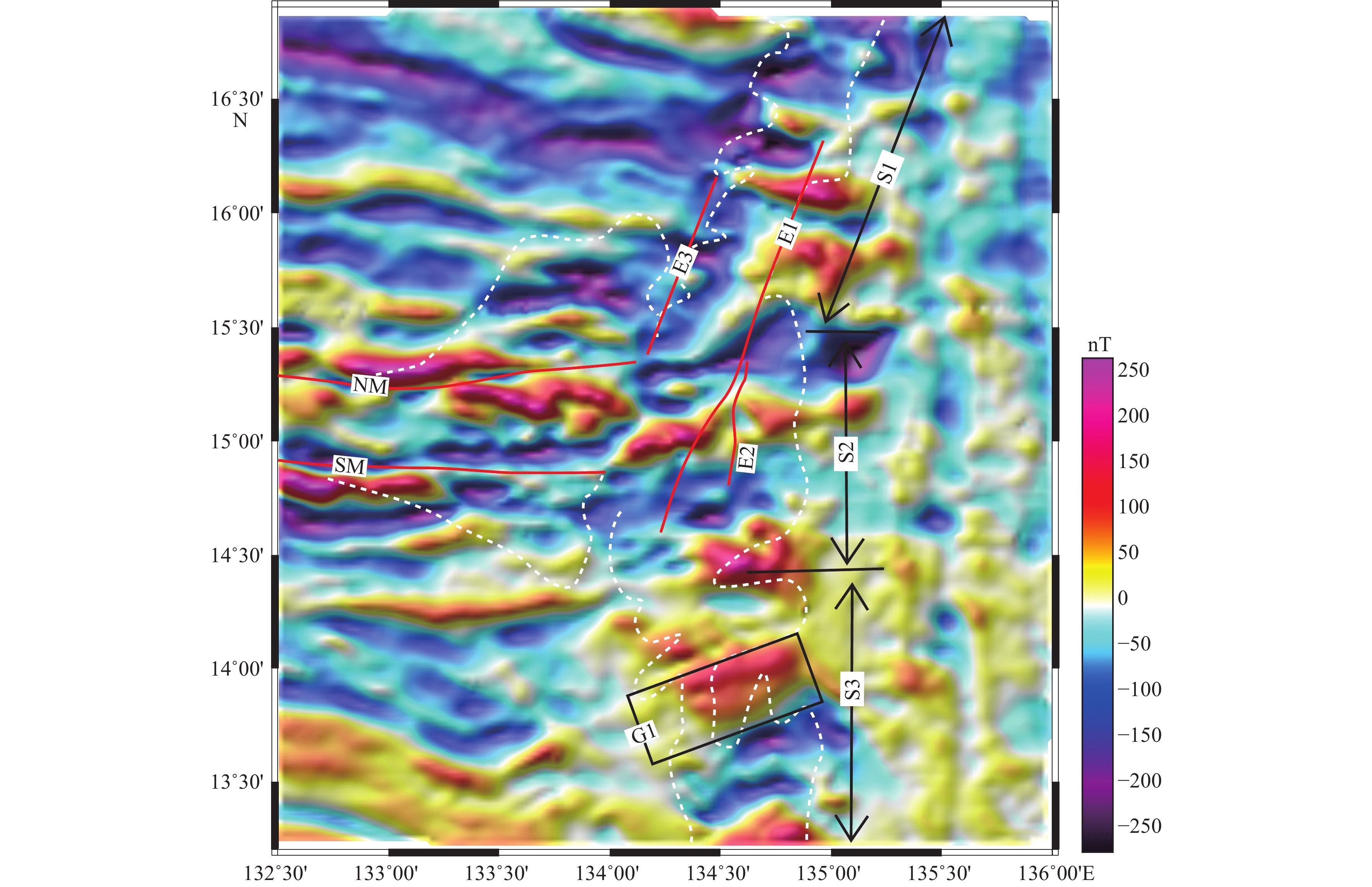
Figure 2.
Bathymetric map of the KPR-CBR triple-junction and its surrounding areas. Major submarine topographic features are denoted and labeled. The KPR is divided into three segments (S1-S3) according to the water depth and direction of each segment. Escarpments on the KPR (E1-E3) and those bounding the CBR (NM and SM) are delineated by solid red lines. Topographic highs including the KPR and the edifices on both sides of the eastern CBR are outlined by dotted white lines. Five small depressions are identified in the central segment of KPR (D1-D5) and outlined by dotted red lines. The arcuate lineament feature is identified and delineated by a dotted black line (AL). The black rectangle (G1) represents the topographic gap which almost completely disconnected the KPR. NM‒Northern Margin, SM‒Southern Margin, AL‒Arcuate Lineament.
-
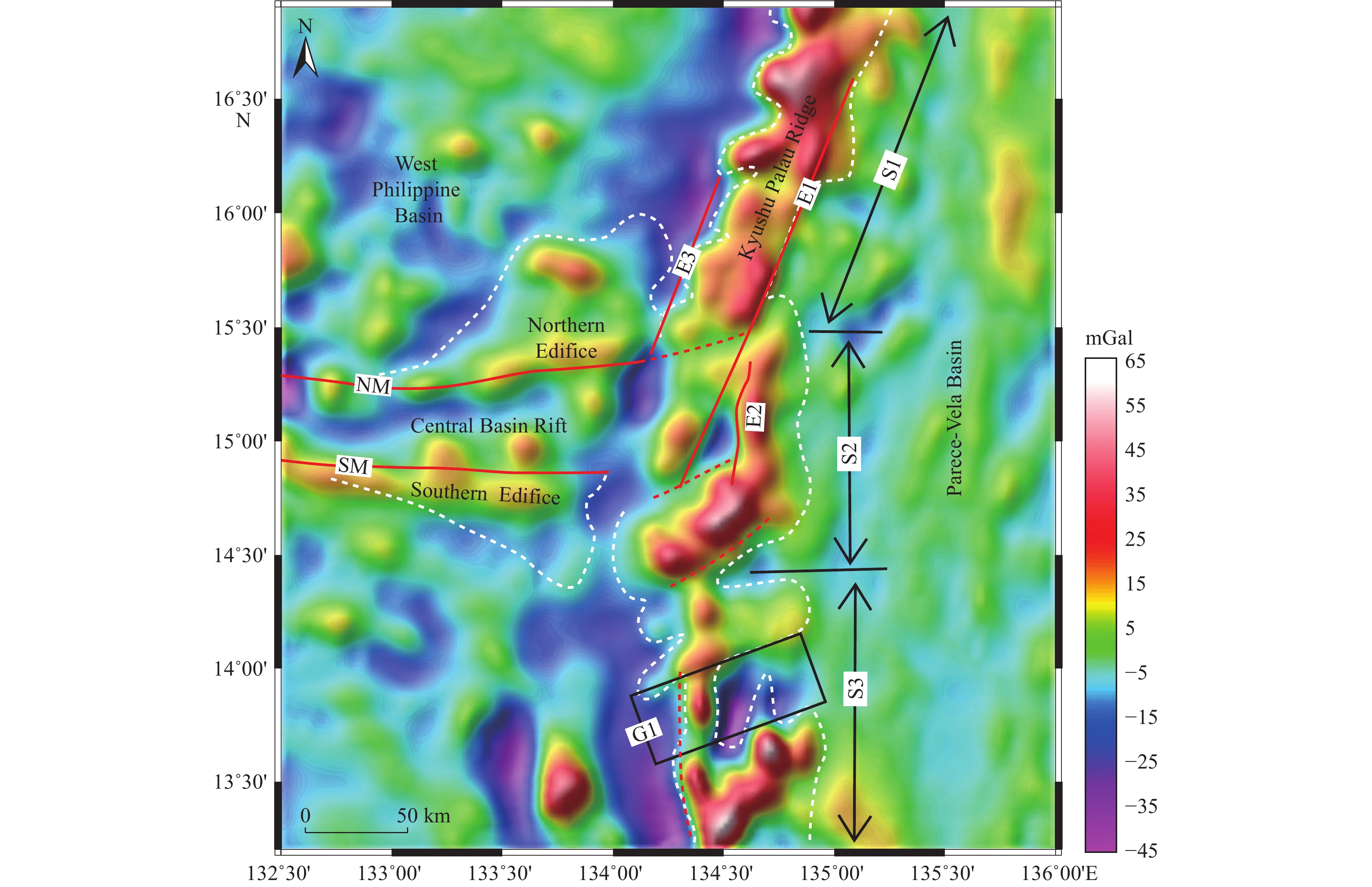
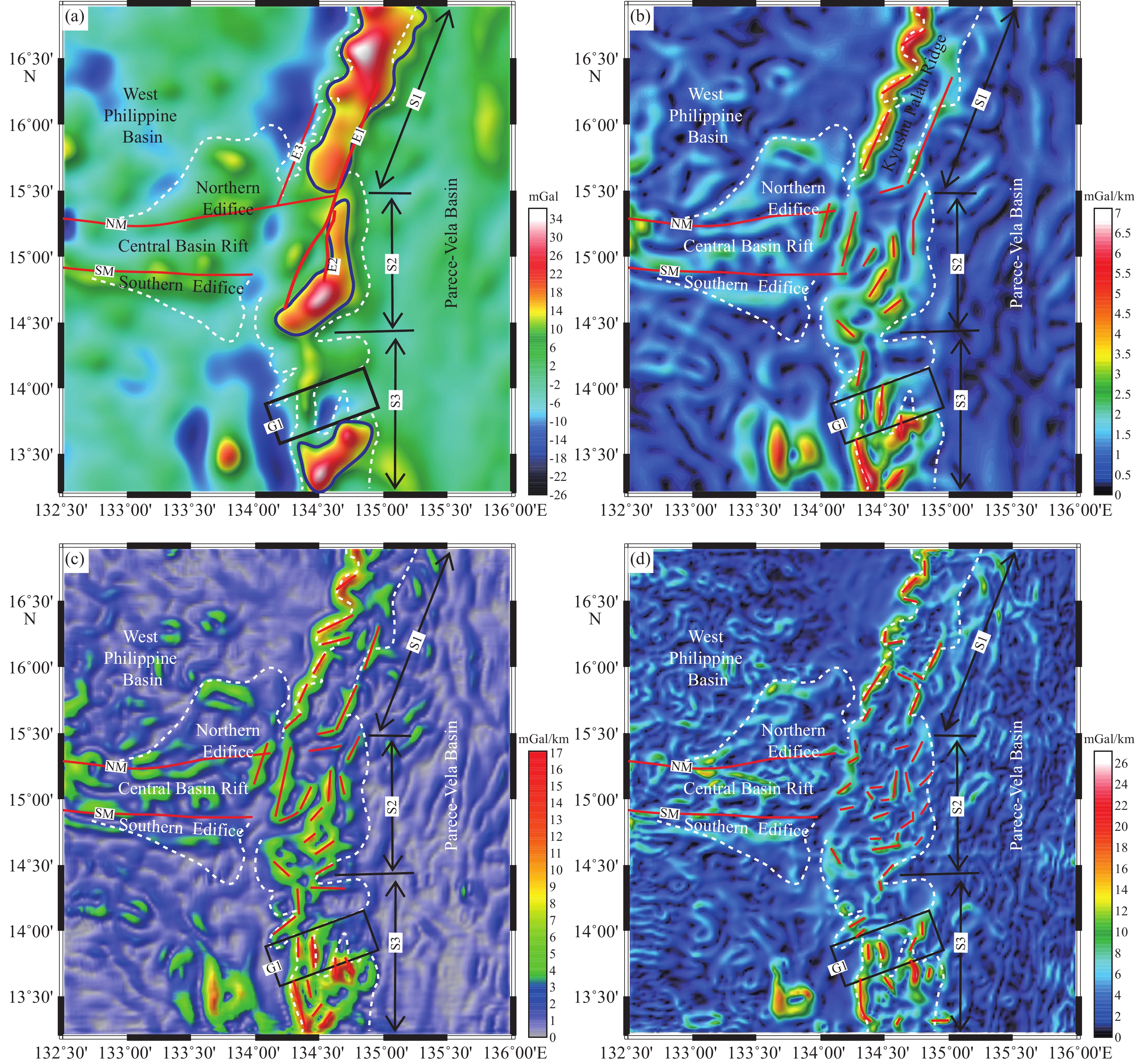
Figure 3.
Free-air gravity anomaly of the KPR-CBR triple-junction and surrounding regions. Dotted red lines are the inferred structural boundaries. Topographic elements (E1-3 and G1) are identical with those in Fig. 1.
-
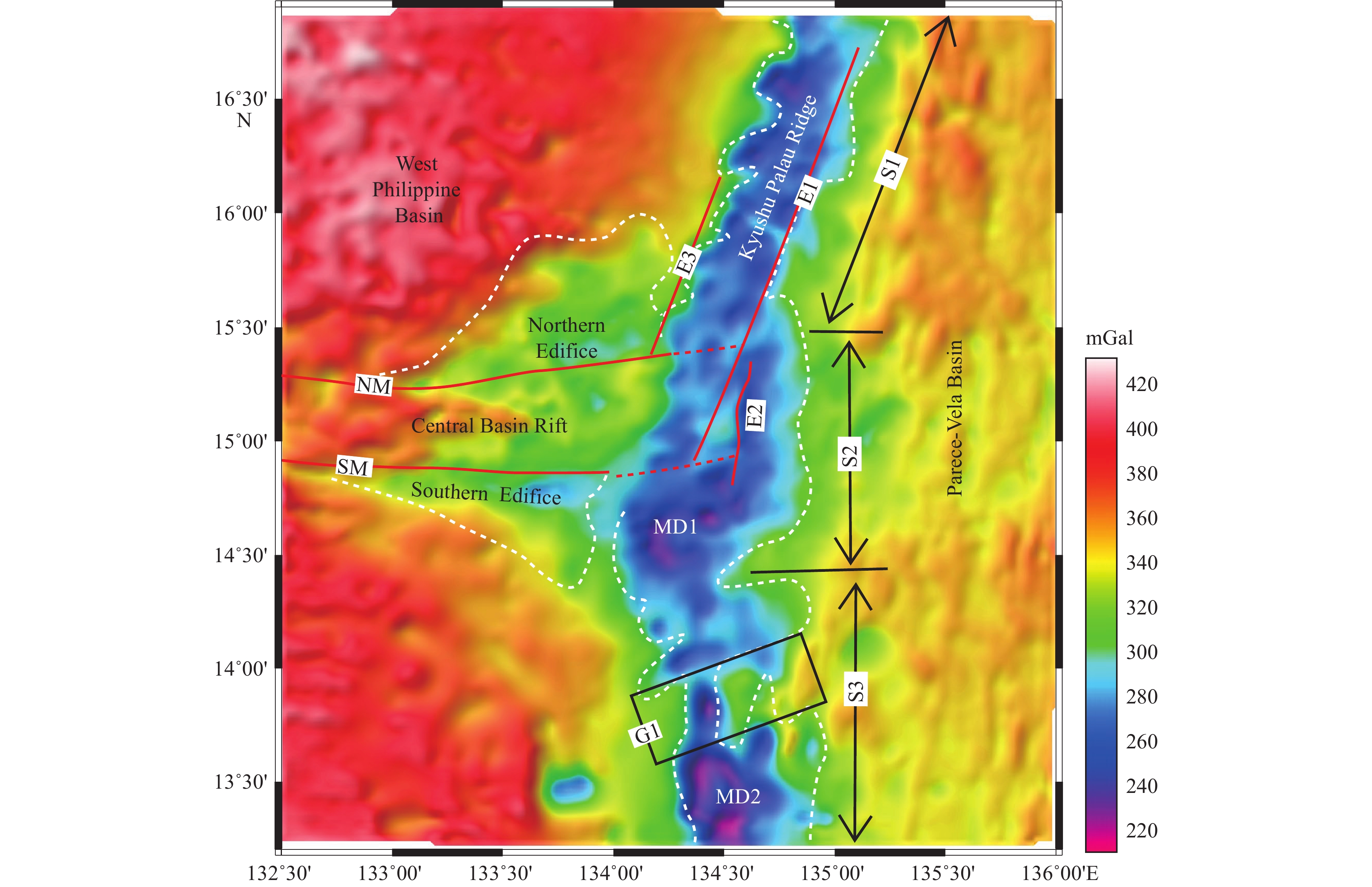
Figure 4.
Bouguer gravity anomaly of the KPR-CBR triple-junction and surrounding regions. Dotted red lines are the inferred structural boundaries. Topographic elements (E1-3 and G1) are identical with those in Fig. 1.
-
Figure 5.
Map showing the total-field magnetic anomalies of the KPR-CBR triple-junction and its adjacent areas (Topographic features are identical with those in Fig. 1).
-
Figure 6.
Calculation results of free-air and Bouguer gravity anomalies. a‒5 km upward continuation of free-air gravity anomaly. Topographic elements are identical with those in Fig. 1. Major gravity highs are outlined by solid black lines. b‒total horizontal derivative (THD) of the 5-km upward continued free-air gravity anomaly. c‒total horizontal derivative (THD) of free-air gravity anomaly. d‒total horizontal derivative (THD) of Bouguer gravity anomaly. Maximum belts which may represent major structural boundaries are highlighted by solid red lines in (a), (b), and (c).
-
Figure 7.
Schematic structural map of the KPR-CBR triple-junction and surrounding region. Bathymetric highs are outlined by dotted black lines. Linear seafloor fabrics are delineated by thin black lines. Thick solid red lines represent major faults those are evidenced by bathymetry, gravity, magnetic data and their calculation results. The Central Basin Fault and its eastern prolongation are colored into yellow. Dark grey areas represent major volcanic complexes outlined by 5 km upward continuation of free-air gravity anomalies. The northern, middle, and southern segments of KPR separated by major discontinuities are colored into green, light blue, and dark blue, respectively. Note that the structural boundary between the southern and middle segment is located near G1 area, slightly different from the topographic boundary of these two segments.