
| Citation: |
Zhen Lin, Wen-chao Lü, Zi-ying Xu, Peng-bo Qin, Hui-qiang Yao, Xiao Xiao, Xin-he Zhang, Chu-peng Yang, Xiang-yu Zhang, Jia-le Chen, 2021. Characteristics of gravity and magnetic fields and deep structural responses in the southern part of the Kyushu-Palau Ridge, China Geology, 4, 553-570. doi: 10.31035/cg2021085

|
Characteristics of gravity and magnetic fields and deep structural responses in the southern part of the Kyushu-Palau Ridge
-
Abstract
The southern part of the Kyushu-Palau Ridge (KPR) is located at the conjunction of the West Philippine Basin, the Parece Vela Basin, the Palau Basin, and the Caroline Basin. This area has extremely complex structures and is critical for the research on the tectonic evolution of marginal seas in the Western Pacific Ocean. However, only few studies have been completed on the southern part, and the geophysical fields and deep structures in this part are not well understood. Given this, this study finely depicts the characteristics of the gravity and magnetic anomalies and extracts information on deep structures in the southern part of the KPR based on the gravity and magnetic data obtained from the 11th expedition of the deep-sea geological survey of the Western Pacific Ocean conducted by the Guangzhou Marine Geological Survey, China Geological Survey using the R/V Haiyangdizhi 6. Furthermore, with the data collected on the water depth, sediment thickness, and multichannel seismic transects as constraints, a 3D density model and Moho depths of the study area were obtained using 3D density inversion. The results are as follows. (1) The gravity and magnetic anomalies in the study area show distinct zoning and segmentation. In detail, the gravity and magnetic anomalies to the south of 11°N of the KPR transition from high-amplitude continuous linear positive anomalies into low-amplitude intermittent linear positive anomalies. In contrast, the gravity and magnetic anomalies to the north of 11°N of the KPR are discontinuous and show alternating positive and negative anomalies. These anomalies can be divided into four sections, of which the separation points correspond well to the locations of deep faults, thus, revealing different field-source attributes and tectonic genesis of the KPR. (2) The Moho depth in the basins in the study area is 6–12 km. The Moho depth in the southern part of KPR show segmentation. Specifically, the depth is 10‒12 km to the north of 11°N, 12‒14 km from 9.5°N to 11°N, 14–16 km from 8.5°N to 9.5°N, and 16‒25 km in the Palau Islands. (3) The KPR is a remnant intra-oceanic arc with the oceanic-crust basement.which shows noticeably discontinuous from north to south in geological structure and is intersected by NEE-trending lithospheric-scale deep faults. With large and deep faults F3 and F1 (the Mindanao fault) as boundaries overall, the southern part of the KPR can be divided into three zones. In detail, the portion to the south of 8.5°N (F3) is a tectonically active zone, the KPR portion between 8.5°N and 11°N is a tectonically active transition zone, and the portion to the north of 11°N is a tectonically inactive zone. (4) The oceanic crust in the KPR is slightly thicker than that in the basins on both sides of the ridge, and it is inferred that the KPR formed from the thickening of the oceanic crust induced by the upwelling of deep magma in the process of rifting of remnant arcs during the Middle Oligocene. In addition, it is inferred that the thick oceanic crust under the Palau Islands is related to the constant upwelling of deep magma induced by the continuous northwestward subduction of the Caroline Plate toward the Palau Trench since the Late Oligocene. This study provides a scientific basis for systematically understanding the crustal attributes, deep structures, and evolution of the KPR.
-

-
References
Bayley D. 2019. Empirical and Mechanistic Approaches to Understanding and Projecting Change in Coastal Marine Communities. London, University College London, Ph.D thesis, 1‒28. Deschamps A, Lallemand S. 2002. The West Philippine basin: An Eocene to early Oligocene back arc basin opened between two opposed subduction zones. Journal of Geophysical Research Solid Earth, 107(B12), EPM-1-EPM 1‒24. doi: 10.1029/2001JB001706. Dong DD, Zhang ZY, Zhang GX, Bai YL, Fan JL. 2017. Tectonic and sedimentary characteristics of the West Philippine Basin and their implications for the evolution of the basin: Evidence from a large geophysical section. Oceanologia et Limnologia sinica, 48(6), 1415–1425 (in Chinese with English abstract). doi: 10.11693/hyhz20170700178. Ding W, Zhen S, Dadd K, Fang Y, Li J. 2018. Structures within the oceanic crust of the central south china sea basin and their implications for oceanic accretionary processes. Earth and Planetary Science Letters, 488, 115–125. doi: 10.1016/j.jpgl.2018.02.011. Fang Y, Li J, Li M, Ding W, Jie Z. 2011. The formation and tectonic evolution of Philippine Sea Plate and KPR. Acta Oceanologica Sinica, 30(4), 75–88 (in Chinese with English abstract). doi: 10.1007/s13131-011-0135-2. Geng M, Welford JK, Farquharson CG, Hu X. 2019. Gravity modeling for crustal-scale models of rifted continental margins using a constrained 3D inversion method. Geophysics, 1–55. doi: 10.1190/geo2018-0134.1. Hall R, Ali JR, Anderson CD, Baker SJ. 1995. Origin and motion history of the Philippine Sea Plate. Tectonophysics, 251(1‒4), 229‒250. doi: 10.1016/0040-1951(95)00038-0. Huang JX, Wang QB, Zhang C, Feng JK. 2017. Research on fast construction method of large‒scale point quality model. Journal of Geodesy and Geodynamics, 37(1), 11–15 (in Chinese with English abstract). doi: 10.14075/j.jgg.2017.01.003. Karig DE. 1975. Basin genesis in the Philippine sea. Initial Reports of Deep Sea Drilling Project, 31, 87–93. doi: 10.2973/dsdp.proc.31.142.1975. Kroenke L. 1981. Site 451: East edge of the West Mariana Ridge. Initial Report of the Deep Sea Drilling Project, 59, 405–483. doi: 10.2973/dsdp.proc.59.106.1981. Lallemand S. 2016. Philippine Sea Plate inception, evolution, and consumption with special emphasis on the early stages of Izu-Bonin-Mariana subduction. Progress in Earth and Planetary Science, 3(1), 1–27. doi: 10.1186/s40645-016-0085-6. Lemenkova P. 2020. Cartographic interpretation of the seafloor geomorphology using GMT: A case study of the Manila Trench, South China Sea. Aksaray University Journal of Science and Engineering, 4(1), 1–18. doi: 10.29002/asujse.604761. Li HL, Wu ZC, Ji F, Gao JY, Yang CG, Yuan Y, Xu MJ, Zhang JL. 2020. Crustal density structure of the northern South China Sea from constrained 3-D gravity inversion. Chinese Journal of Geophysics, 3(5), 1894–1912 (in Chinese with English abstract). Li JB, Fang YX, Wu ZY, Tang Y. 2013. Technologies and their application for the delimitation of the continental shelf beyond 200 nautical miles. Progress in Geophysics, 28(2), 531–539. doi: 10.6038/pg20130201. Li XJ, Wang Z, Yao YJ, Gao HF, Li B. 2017. Tectonic characteristics and evolution of the western Pacific Rim. Geology in China, 44(6), 1102–1114 (in Chinese with English abstract). doi: 10.12029/gc20170605. Li Y, Oldenburg DW. 1996. 3-D inversion of magnetic data. Geophysics, 61(2), 394–408. doi: 10.1190/1.1443968. Li Y, Oldenburg DW. 1998. 3-D inversion of gravity data. Geophysics, 63(1), 109–119. doi: 10.1190/1.1444302. Li Y, Oldenburg DW. 2000. Joint inversion of surface and three-component borehole magnetic data. Geophysics, 65, 540–552. doi: 10.1190/1.1826293. Malyarenko AN, Lelikov EP. 1995. Granites and associated rocks in the Philippine sea and the east China sea. In: Takayama H, Shcheka SA, Isezaki N et al. (Eds). Geology and Geophysics of the Philippine Sea. Terrapot. Tokyo, 311‒328. ISBN: 4887041187 Maus S. 2009. Earth magnetic anomaly grid released. Eos, Transactions, American Geophysical Union, 90(28), 239‒239. doi: 10.1029/ 2009EO280003 Mrozowski C, Hayes E. 1979. The evolution of the Parece Vela Basin, eastern Philippine Sea. Earth and Planetary Science Letters. 46(1), 49‒67. doi: 10.1016/0012-821X(79)90065-7. Nishizawa A, Kaneda K, Katagiri Y. Kasahara J. 2007. Variation in crustal structure along the Kyushu-Palau Ridge at 15°–21°N on the Philippine Sea plate based on seismic refraction profiles. Earth, Planets and Space, 59(6), e17‒e20. doi: 10.1186/BF03352711. Nocedal J, Wright SJ. 2006. Numerical Optimization. Evanston, Springer, 102‒119 Oldenburg DW. 1984. An introduction to linear inverse theory. IEEE Transactions on Geoscience and Remote Sensing, GE-22, 665‒674. doi: 10.1109/TGRS.1984.6499187. Ozima M, Kaneoka I, Saito K, Honda M, Yanagisawa M, Takigami Y. 1983. Summary of geochronological studies of submarine rocks from the western Pacific Ocean. Geodynamics of the western Pacific-Indonesian region, 11, 137–142. doi: 10.1016/0012-821X(77)90087-5. Pilkington M. 1997. 3-D magnetic imaging using conjugate gradients, Geophysics, 62(4), 1132–1142. doi: 10.1190/1.1826377. Portniaguine O, Zhdanov MS. 2002. 3-D magnetic inversion with data compression and image focusing. Geophysics, 67, 1532–1541. doi: 10.1190/1.1512749. Portniaguine O, Zhdanov MS. 1999. Focusing geophysical inversion images. Geophysics, 64, 874–887. doi: 10.1190/1.1444596. Sandwell DT, Harper H, Tozer B, Harper H, Tozer B, Smith WH. 2019. Gravity field recovery from geodetic altimeter missions. Advances in Space Research, 68(2), 1059–1072. doi: 10.1016/j.asr.2019.09.011. Sandwell, DT, Mueller RD, Smith WHF, Garcia, E, Francis R. 2014. New global marine gravity model from CryoSat-2 and Jason-1 reveals buried tectonic structure. Science, 346(6205), 65–67. doi: 10.1126/science.1258213. Scott R, Kroenke L, Zakariadze G, Sharaskin A. 1981. Evolution of the South Philippine Sea: Deep Sea Drilling Project Leg 59 Results. Initial Reports of the Deep Sea Drilling Program, 59, 5‒19. doi 10.2973/dsdp.proc.59.138.1981 Shin YH, Choi, KS, Koh, JS, Yun SH, Nakamura, E, Na, SH. 2012. Lithospheric‐folding‐based understanding on the origin of the back‐arc basaltic magmatism beneath Jeju volcanic island. Tectonics, 31(4), TC4005. doi: 10.1029/2011TC003092. Sunkel H. 1983. The Generation of A Mass Point Model from Surface Gravity Data. Ohio, Ohio State University, (AD-A142327) N84-29882. Tang Y, Li MB, Li JB, Wu ZC. 2011. The geomorphological features and continuity of the Kyushu-Palau Ridge (KPR). Acta Oceanologica Sinica, 30(5), 114–124 (in Chinese with English abstract). doi: 10.1007/s13131-011-0136-1. Tikhonov AN, Arsenin VY. 1997. Solutions of ill-posed problems. Washington, DC: W.H. Winston and Sons, 56, 87. doi: 10.1137/1021044 Wang JQ, Li JC, Zhao GQ, Han J C. 2010. Construction and analysis of gravity three-layer point mass model. Acta Geodaetica Et Cartographica Sinica, 39(5), 503–507 (in Chinese with English abstract). Welford JK, Hall J. 2007. Crustal structure of the Newfoundland rifted continental margin from constrained 3-D gravity inversion. Geophysical Journal International, 171, 890–908. doi: 10.1111/j.1365-246X.2007.03549.x. Welford JK, Shannon PM, Reilly BM, O'Reilly BM, Hall J. 2010. Lithospheric density variations and Moho structure of the Irish Atlantic continential margin from constrained 3-D gravity inversion, Geophysical Journal International, 183, 79‒95. doi: 10.1111/j.1365-246X.2010.04735.x Whittaker JM, Goncharov A, Williams SE, Müller RD, Leitchenkov G. 2013. Global sediment thickness dataset updated for the Australian-Antarctic Southern Ocean. Geochemistry, Geophysics, Geosystems, 14(8), 3297‒3305. doi: org/10.1002/ggge.20181 Wu J, Suppe J, Lu R, Kanda R. 2016. Philippine Sea and East Asian plate tectonics since 52 Ma constrained by new subducted slab reconstruction methods. Journal of Geophysical Research:Solid Earth, 121(6), 4670–4741. doi: 10.1002/2016JB012923. Wu SG, Fan JK, Dong DD. 2013. On the tectonic division of Philippine Sea plate. Chinese Journal of Geology, 48(3), 677–692 (in Chinese with English abstract). doi: 10.3969/j.issn.0563-5020.2013.03.008. Wu XP. 1984. Point mass model of local gravitational field. Acta Geodaetica Sinica, 13(4), 250–258 (in Chinese with English abstract). Wu X, Zhang CD, Liu XG. 2009. Construction of point mass model based on satellite gravity gradient data. Journal of Geomatics Science and Technology, 26(6), 414–417 (in Chinese with English abstract). Xu ZY, Wang J, Gao HF, Yao YG, Zhu RW, Tang JL, Sun MJ. 2020. Development characteristics and genetic mechanism of faults in southern Zhongsha block. Geology in China, 47(5), 1438–1446.) (in Chinese with English abstract). doi: 10.12029/gc20200510. Zhang J, Li JB, Ding WW. 2012. Review on crustal structure and evolution of the Kyushu-Palau Ridge. Advances in Marine Science, 30(4), 595–607 (in Chinese with English abstract). doi: 10.1007/s11783-011-0280-z. Zhang L, Koyama T, Utada H, Yu, P, Wang JA. 2012. Regularized three-dimensional magnetotelluric inversion with a minimum gradient support constraint. Geophysical Journal International, 189, 296–316. doi: 10.1111/j.1365-246X.2012.05379.x. Zhang Y, Yao YJ, Li XJ, Shang LN, Yang CP, Wang ZB, Wang MJ, Gao HF, Peng XC, Huang L, Kong XH, Wang J, Mi BB, Zhong HX, Chen HJ, Wu H, Luo WD, Mei X, Hu G, Zhang JY, Xu ZY, Tian ZX, Wang Z, Li X, Wang ZL. 2020. Tectonic evolution and resource-environmental effects of the China Sea and its adjacent areas under the multi-layer dynamics of the East Asian ocean-land convergence belt since the Mesozoic. Geology in China, 47(5), 39,1271–1309 (in Chinese with English abstract). doi: 10.12029/gc20200501. Zhang ZY, Fan JK, Bai YL, Dong DD. 2018. Joint gravity, magnetic and seismic inversion of typical profiles in the China Sea and western Pacific. Chinese Journal of Geophysics, 61(7), 2871–2891 (in Chinese with English abstract). doi: 10.6038/cjg2018L0301. Zhao MH, He EY, Sibuet JC, Sun LT, Qiu XL, Tan PC, Wang J. 2018. Postseafloor spreading volcanism in the central east south China sea and its formation through an extremely thin oceanic crust. Geochemistry, Geophysics, Geosystems, 19(3), 185−198. doi: 10.1002/2017GC007034 (in Chinese with English abstract) Zhdanov MS. 2002. Geophysical inverse theory and regularization problems. Salt Lake City, Elsevier. Zubaidah T, Korte M, Mandea M, Hamoudi M. 2014. New insights into regional tectonics of the Sunda-Banda Arcs region from integrated magnetic and gravity modelling. Journal of Asian Earth Sciences, 80, 172–184. doi: 10.1016/j.jseaes.2013.11.013. -
Access History

Figures(14)

Export File
Citation
Zhen Lin, Wen-chao Lü, Zi-ying Xu, Peng-bo Qin, Hui-qiang Yao, Xiao Xiao, Xin-he Zhang, Chu-peng Yang, Xiang-yu Zhang, Jia-le Chen, 2021. Characteristics of gravity and magnetic fields and deep structural responses in the southern part of the Kyushu-Palau Ridge, China Geology, 4, 553-570. doi: 10.31035/cg2021085
Format
Content
 DownLoad:


-
Figure 1.
Map showing the regional tectonic location of the Philippine Sea Plate and the location of the study area.
-
Figure 2.
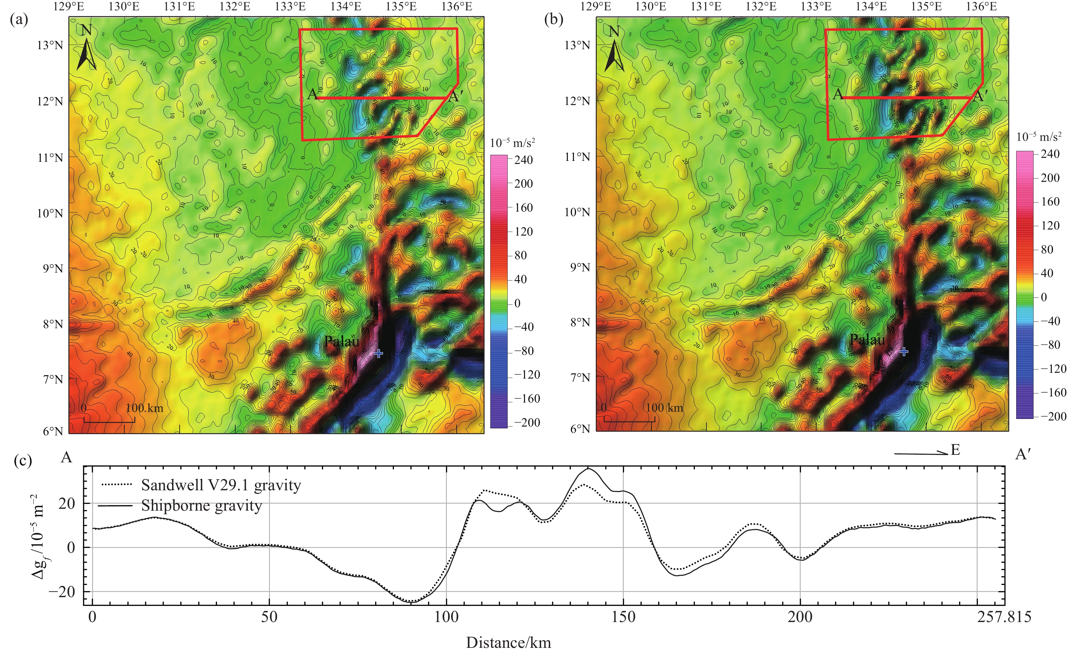
Diagrams showing the comparison results of gravity data. a‒gravity data from Sandwell DT V29.1, where the red box denotes the scope of shipborne surveys area; b‒data outside the red box are gravity data from Sandwell DT V29.1, while the data inside the red box are the gravity data from shipborne survey (the two groups of data were stitched and then gridded); c‒comparison between gravity data from Sandwell DT V29.1 and surveyed gravity data along section AA′ in the study area.
-
Figure 3.
Diagrams showing the comparison results of magnetic data. a‒magnetic data from EMAG2, where the red box denotes the scope of shipborne surveys area; b‒data outside the red box are magnetic data from EMAG2, while the data in the red box are shipborne surveyed magnetic data after 4 km-upward continuation to (the two groups of data are not sutured); c‒comparison between magnetic data from EMAG2 and shipborne surveyed magnetic data along section AA′ in the study area.
-
Figure 4.
Free-air gravity anomalies and zoning. I‒gently changing anomalous zone in the West Philippine Basin; II‒gently changing anomalous zone in the Parece Vela Basin; III‒gently changing anomalous zone in the Palau-Parece Vela Basin; IV‒anomalous zone in the Caroline Plate; V‒dramatically changing anomalous zone in the Palau.
-
Figure 5.
Distribution of free-air gravity anomalies and faults. a–free-air gravity anomalies continued upward 5 km and faults; b–free-air gravity anomalies continued upward 10 km and faults; c–free-air gravity anomalies continued upward 15 km and faults; d–free-air gravity anomalies continued upward 20 km and faults. The white lines denote faults.
-
Figure 6.
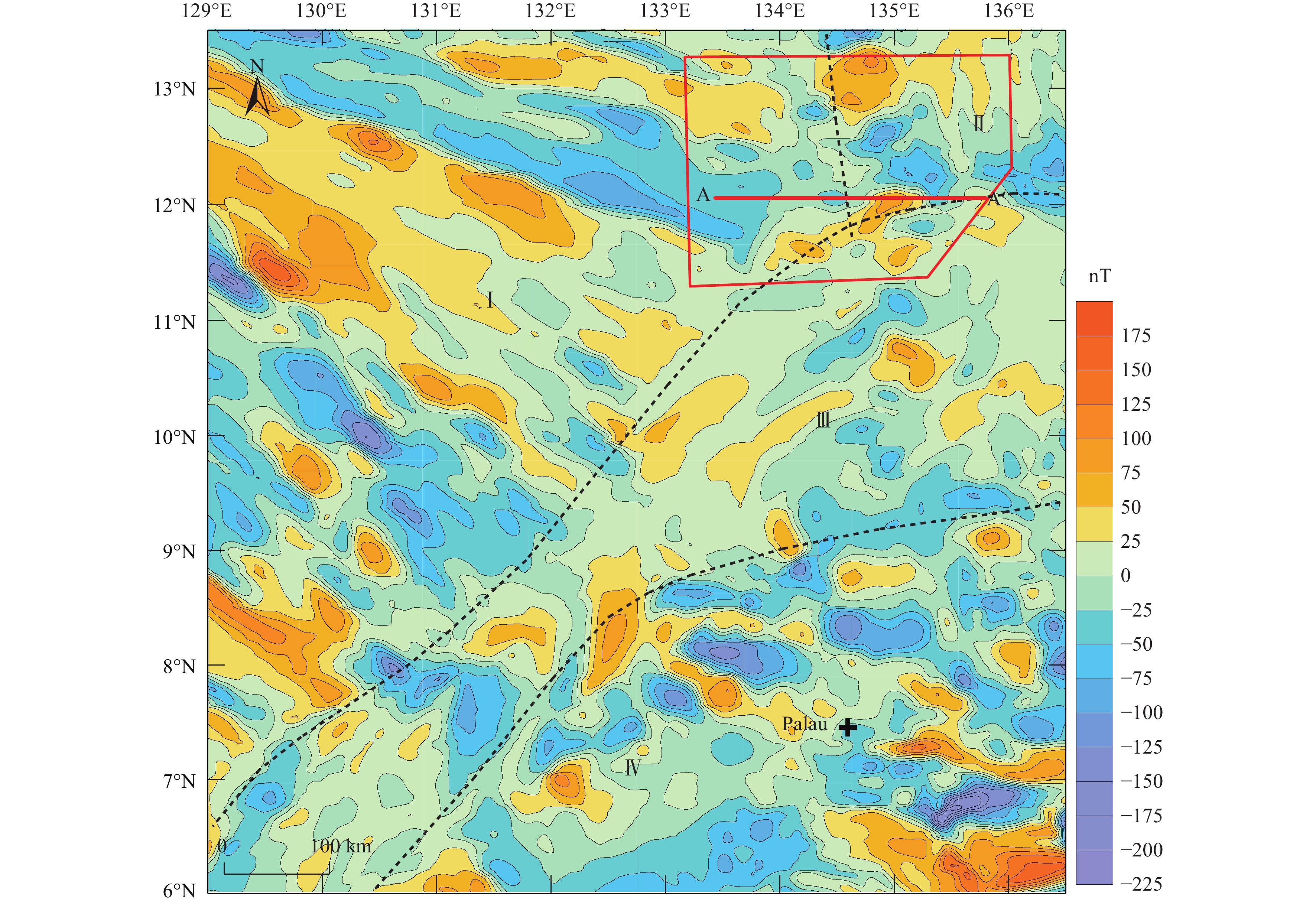
Magnetic anomalies and zoning. I‒banded magnetic anomalous zone in the West Philippine Basin; II‒banded magnetic anomalous zone in the Parece Vela Basin; III‒ magnetic quiet anomalous zone in north Palau; IV‒positive and negative magnetic anomalous zone in south Palau.
-
Figure 7.
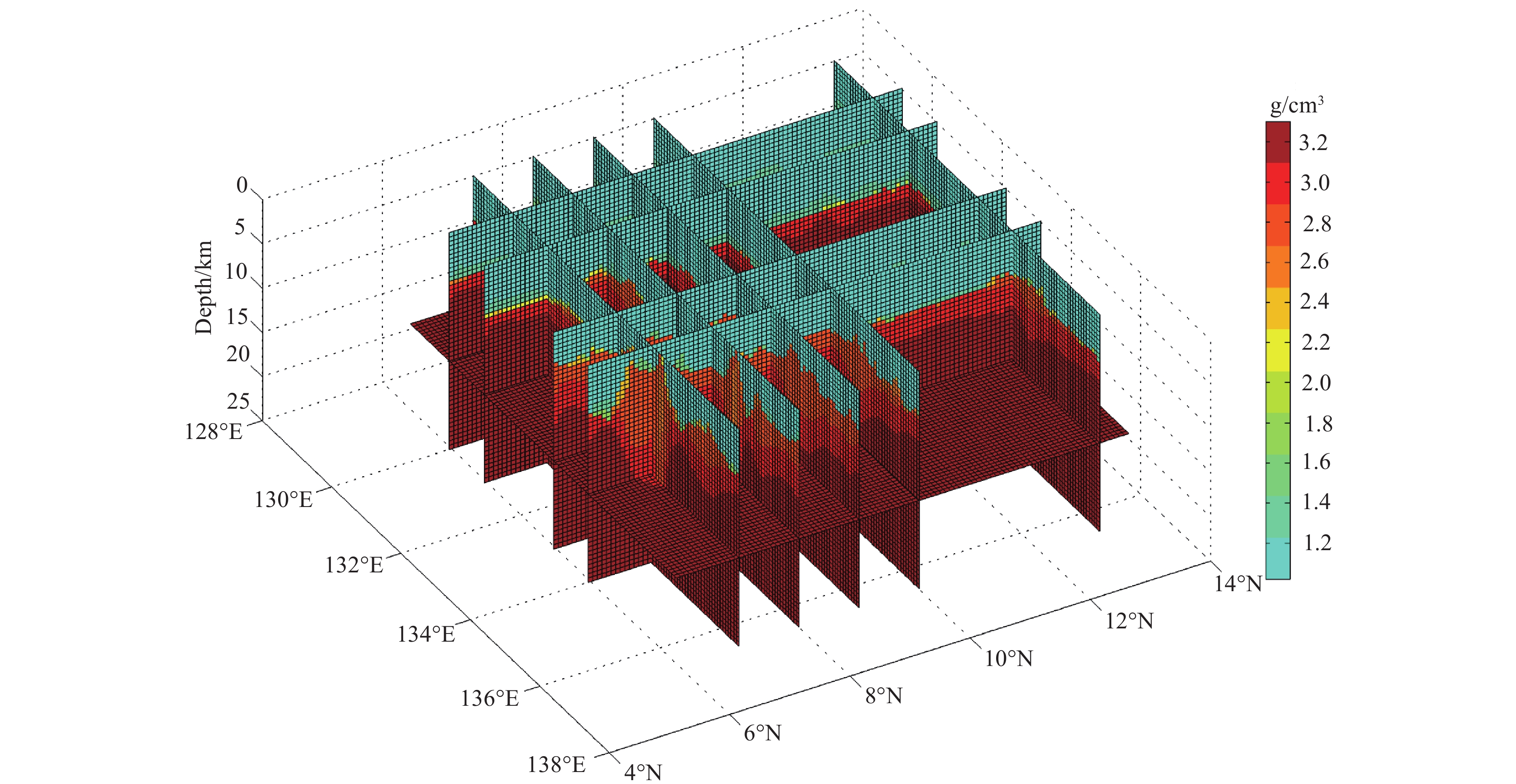
3D density model for the study area.
-
Figure 8.
The Moho depth (black lines denote faults, and the pink line represents the position of section BB′ in Fig. 9).
-
Figure 9.
The Moho depth in the KPR from south to north.
-
Figure 10.
Maps showing the distribution of faults in the study area. a‒second vertical derivative of gravity anomalies upward continued to 10 km and the faults; b‒second vertical derivative of gravity anomalies upward continued to 15 km and the faults; c‒inversion results of gravity anomalies using the Euler deconvolution method and the faults (black crosses represent Euler deconvolution solutions of depths more than 5 km); d‒first vertical derivative of EMAG2 magnetic anomalies upward continued to 5 km and the faults (black crosses represent Euler deconvolution solutions of depths more than 5 km, and white and red lines represent faults).
-
Figure 11.
Distribution of faults in the northern KPR in the study area. a‒distribution of shipborne surveyed gravity anomalies and faults; b‒distribution of shipborne surveyed magnetic anomalies and faults; c‒distribution of terrain and faults; d‒distribution of shipborne surveyed bouguer anomaly and faults. Pink lines represent faults.
-
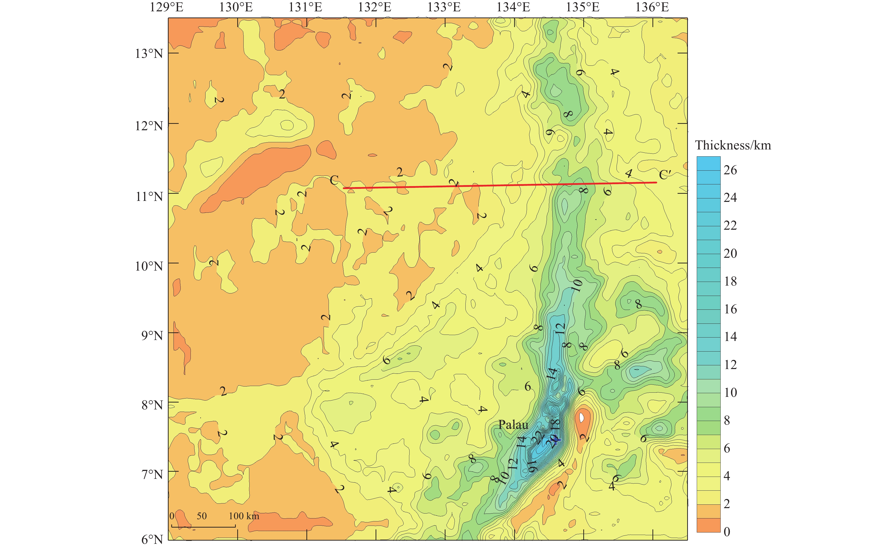
Figure 12.
Thickness of the crusts in the study area (the red line represents the position of section CC′).
-
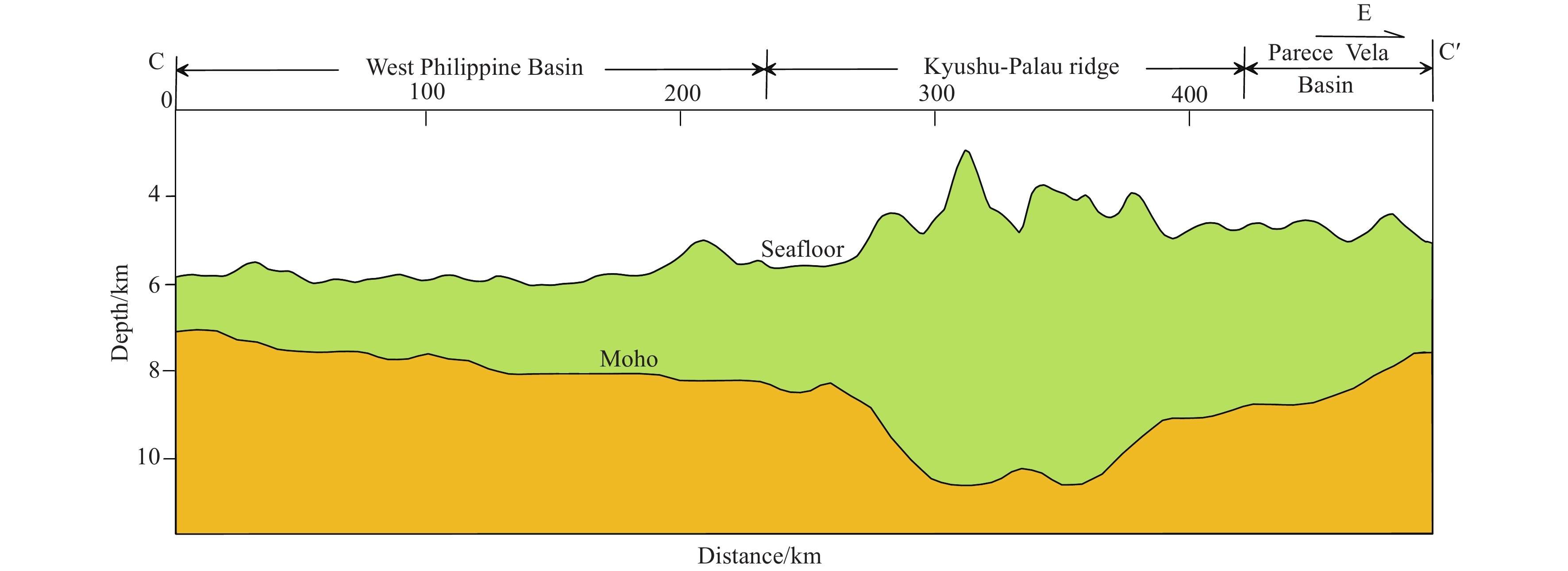
Figure 13.
Section spanning the crustal structure of the KPR (the survey line is shown in see Fig. 12).
-
Figure 14.
Characteristics of seismic transects of the KPR (see L1 and L2 in Fig. 1 for section locations; modified from Dong DD et al., 2017).