

| Citation: |
En-ran Liu, Di-shi Shi, Yan-hong Wang, Qiu-chen Xu, Bu-qing Wang, Peng-ju Yang, Chuan-fang Jiang, Jian-wei Zang, 2020. Sequence stratigraphic framework and sedimentary model of Shanxi Formation in northeast Zhoukou Depression of the North China Plate, China Geology, 3, 575-590. doi: 10.31035/cg2020067

|
Sequence stratigraphic framework and sedimentary model of Shanxi Formation in northeast Zhoukou Depression of the North China Plate
-
Abstract
The sequence stratigraphic framework of Shanxi Formation in the northeast Zhoukou Depression was established based on detailed sequence stratigraphical and sedimentological analysis by utilizing the logging and core data of six wells drilled in the eastern tectonic unit of Zhoukou Depression. It was divided into three third-order sequences, namely SQs1, SQs2, and SQs3 from bottom to top. Each sequence can be divided into a transgressive system tract (TST) and a highstand system tract (HST). Furthermore, four sequence boundaries and three maximum flooding surfaces were identified, and they are the bottom interface SBs and maximum flooding surface mfss1 of SQs1, the bottom interface SBs1 and maximum flooding surface mfss2 of SQs2, the bottom interface SBs3 and maximum flooding surface mfss3 of SQs3, and the top interface SBx from bottom to top. Carbonate tidal flat–clastic tidal flat sedimentary system developed in Shanxi Formation in the northeast Zhoukou Depression (also referred to as the study area) under the control of regression. Meanwhile, four sedimentary microfacies were identified in the sedimentary system, which are lime-mud flats, sand flats, mixed flats, and mud flats. The transgression in the study area occurred from the southeast to the northwest. Therefore, the northwestern part is the seaward side, and the southeastern part is the landward side. As revealed by relevant drilling data, SQs1 of the Shanxi Formation is characterized by the development of limestone and carbonaceous mudstone, with limestone, dark mudstone, and carbonaceous mudstone mainly developing. Meanwhile, lime-mud flats were mainly deposited in it. During the periods of SQs2 and SQs3, the sedimentary environment of the study area changed from the carbonate tidal flats to clastic tidal flats as the coastline migrated towards the sea. In these periods, sand flats mainly developed near the maximum flooding surfaces and were relatively continuous in the eastern and southern parts of the transgressive system tract; mixed flats were relatively continuous in the western and northern parts of the transgressive system tract as well as the eastern and southern parts of the highstand system tract; mud flats widely developed in the highstand system tract. Peat flats mainly developed in the period of HSTs2, with coal seams relatively developing in the southeastern part of the study area as revealed by drilling data. The peat flats in SQs2 are favorable hydrocarbon source layers, the lime-mud flats in SQs1 and sand flats formed in the transgression periods of SQs2 and SQs3 constitute favorable hydrocarbon reservoirs, and the mud flats form in the transgressions periods serve as favorable cap rocks. Therefore, the study area features a reservoir-cap assemblage for self-generating and self-storing of hydrocarbon, and the southeastern part of the study area can be taken as a favorable exploration area.
-

-
References
[1] Cao GS, Xu GM, Lin YX, Yang QH. 2013. Geometry characteristics of pre-mesozoic basin of eastern part of north China. Journal of Henan Polytechnic University (Narural Science), 32(1), 46–51 (in Chinese with English abstract). [2] Cattaneo A, Steel RJ. 2003. Transgressive deposits: A review of their variability. Earth-Science Reviews, 62(3−4), 187–228. doi: 10.1016/S0012-8252(02)00134-4 [3] Catuneanu O, Abreu V, Bhattacharya JP, Blum MD, Dalrymple RW, Eriksson PG, Fielding CR, Fisher WL, Galloway WE, Gibling MR, Giles KA, Holbrook JM, Jordan R, Kendall CG St C, Macurda B, Martinsen OJ, Miall AD, Neal JE, Nummedal D, Pomar L, Posamentier HW, Pratt BR, Sarg JF, Shanley KW, Steel RJ, Strasser A, Tucker ME, Winker C. 2009. Towards the standardization of sequence stratigraphy. Earth-Science Reviews, 92(1−2), 1–33. doi: 10.1016/j.earscirev.2008.10.003 [4] Cummings DI, Hart BS, Arnott RWC. 2006a. Sedimentology and stratigraphy of a thick, areally extensive fluvial–marine transition, Missisauga Formation, offshore Nova Scotia, and its correlation with shelf margin and slope strata. Bulletin of Canadian Petroleum Geology, 54(2), 152–174. doi: 10.2113/gscpgbull.54.2.152 [5] Cummings DI, Hart BS, Arnott RWC. 2006b. Tidal signatures in a shelf-margin delta: A product of shelf-edge embayment? Geology, 34, 249–252. doi: 10.1130/G22078.1;3figures [6] Dong DX, Shao LY, Li MP. 2017. Study on coal accumulating law of late Carboniferous–early Permian coal–bearing strata in North China Platform. Coal Science and Technology, 45(9), 175–181 (in Chinese with English abstract). [7] Hu ZQ, Zhou XK, Zhu JH. 2006. Hydrocarbon generation potential of Upper Paleozoic in eastern part of North China. Petroleum Exploration and Development, 35(6), 697–701 (in Chinese with English abstract). [8] Kuang HW, Liu YQ, Peng XB, Yang F, Chen MP, Cen C, Peng N, Li JH, Wang XG, Mu PF, Gu XM. 2009. Sedimentary and tectonic features and proto-basin of Early Cretaceous Tanzhuang–Shenqiu Sag, Zhoukou depression, in southern area of North China Craton. Geological Review, 55(6), 801–813 (in Chinese with English abstract). [9] Li P, Zhang JC, Tang X, Huo ZP, Li Z, Luo KY, Li ZM. 2020. Assessment of shale gas potential of the lower Permian transitional Shanxi-Taiyuan shales in the southern North China Basin. Australian Journal of Earth Sciences. https://www.tandfonline.com/loi/taje20. [10] Li S, Yao X. 2011. Discussion on tectonic evolution and hydrocarbon accumulation Upper Palaeozoic formation in northern Zhoukou depression belt. Fault block Oil & Gas Field, 18(5), 564–567 (in Chinese with English abstract). [11] Li WH, Chen JW, Shao J. 1996. Sedimentary facies and framewprk of the Lower Cretaceous strata in the Zhoukou depression. Sedimentary facies and Paleogeography, 16(1), 43–50 (in Chinese with English abstract). [12] Li Y, Ma MY. 2013. Petrography and diagenesis of Permian sandstone reservoirs in Zhoukou Depression, Southern North China Basin. Petroleum Geology & Experiment, 32(4), 640–645 (in Chinese with English abstract). [13] Li ZC, Li WH, Lai SC, Li YX, Li YH, Shang T. 2015. The palaeosafinity analysis of paleogene lutite in Weihe Basin. Acta Sedimentologica Sinica, 33(3), 480–485 (in Chinese with English abstract). [14] Li ZC, Li YX, Li WH, Zhang YX, Ma Y. 2016. The palaeosalinity analysis in Lanzhou Basin of Paleogene mudstone Gansu Province. Chinese Journal of Geology, 51(4), 1344–1356 (in Chinese with English abstract). [15] Lie BF, Wen XD, Li GD. 1999. High resolution sequence stratigraphy analysis on the Permo-Carboniferous in north China Platform. Earth Sicence Frontiers, 6, 81–93 (in Chinese with English abstract). [16] Lin YX, Zhu CZ, Zhao CJ, Wu YC, Li J, Li XQ. 2016. Lithofacies Palaeogeography of the Middle Ordovician in the eastern North China Platform. Petroleum Exploration and Development, 38(5), 559–567 (in Chinese with English abstract). [17] Liu ZW, Zhou LF, He MX. 2008a. Prospects for coal-formed oil and gas exploration of Carboniferous-Permian residual basins in Zhoukou Depression. Xinjiang Petrolume Geology, 29(6), 699–702 (in Chinese with English abstract). [18] Liu ZW, Zhou LF, He MX, Han DC. 2008b. Hydrocarbon accumulation conditions and enrichment controlling factors of Premo-Carboniferous system in Zhoukou depression. Petrolume Geology & Recovery Efficiency, 15(5), 13–16 (in Chinese with English abstract). [19] Longhitano SG, Mellere D, Steel RJ, Ainsworth RB. 2012. Tidal depositional systems in the rock record: A review and new insights. Sedimentary Geology, 279, 2–22. doi: 10.1016/j.sedgeo.2012.03.024 [20] Lu SM, Li JS, Zhao LL, Wei DZ. 2010. Geochemical characteristics of ore-bearing strata and their prospecting implications for the Longqiao—type iron deposit in Lujiang, Zongyang basin, Anhui Province, China. Acta Petrologica Sinica, 26(9), 2577–2586 (in Chinese with English abstract). [21] Quan SJ, Rao D, Kong FJ, Liu SH, Jiang YF. 2002. Potential analysis of the Upper Paleozoic hydrocarbon resources in the Zhoukou depression. Petroleum Geology & Experiment, 26(6), 562–568 (in Chinese with English abstract). [22] Song HB, Li YN, Yu ZF, Liu SX, Hu B, Li ZY. 2018. Sedimentary succession and environment evolution of the Taiyuan Formation in northeastern Qinshui Basin, Shanxi Province. Journal of Palaeogeography (Chinese Edition), 20(4), 623–636 (in Chinese with English abstract). [23] Su JF, Fan DD, Liu JP, Wu YJ. 2020. Anatomy of the transgressive depositional system in a sediment-rich tide-dominated estuary: The paleo-Yangtze estuary, China. Marine and Petroleum Geology, https://doi.org/10.1016/j.marpetgeo.2020.104588. [24] Sun XM, Zhang MS, Long SX, Hao FJ, Liu PJ, Liu CY. 2004. Overthrust tectonic in northern Qinling-Dabie orogenic belt and basin-controlling faults in Zhoukou depression and Hefei basin. Oil & Gas Geology, 25(2), 191–198 (in Chinese with English abstract). [25] Suo RH, Fang JH. 2019. Geochemical characteristics implications on sedimentary environment of Early Permian coal-bearing stratum in Qingdong Well Field. Coal Technology, 38(10), 49–52 (in Chinese with English abstract). [26] Wang JX. 2018. Tidal flat sedimentary characteristics of Silurian Gepingtage formation in Tarim basin. Northwestern Geology, 21(2), 69–74 (in Chinese with English abstract). [27] Ward SL, Scourse JD, Yokoyama Y, Neill SP. 2020. The challenges of constraining shelf sea tidal models using seabed sediment grain size as a proxy for tidal currents. Continental Shelf Research, https://doi.org/10.1016/j.csr.2020.104165. [28] Wheeler H. 1964. Base level, lithosphere surface and time stratigraphy. Geological Society America Bull, 75, 599–610. doi: 10.1130/0016-7606(1964)75[599:BLSAT]2.0.CO;2 [29] Xue LQ, Galloway WE. 1995. High-resolution depositional framework of the Paleocene middle Wilcox strata, Texas Coast al Plain. AAPG Bulletin, 79, 205–230. doi: http://377.rm.cglhub.com/10.1306/8D2B14F8-171E-11D7-8645000102C1865D. [30] Yu BS, Chen JQ, Lin CS. 2001. The comparison of Cambrian-Ordovician sequence stratigraphy between north Tarim platform to Yangtze platform and north China platform. Science in China (Series D), 31(1), 17–25 (in Chinese with English abstract). [31] Zhai CB, Huang ZG, Lin LB. 2005. Structure and petroleum analysis of the Tanzhuang–Shenqiu Sag in the south of North China basin. Petroleum Geology & Experiment, 27(4), 353–359 (in Chinese with English abstract). [32] Zhao KD, Fu XH, Zhang M, Cheng WP, Qu LZ. 2019. Evaluation of organic geochemical characteristics and hydrocarbon generation potential of coal measure mud shale. Coal Science and Technology, 47(11), 182–188 (in Chinese with English abstract). [33] Zhao XY, Zhao S, Ye C, Wang DL. 2017. Study on multi-stages structural styles in eastern Zhoukou Depression. China Energy and Environmental Protection, 39(8), 44–49 (in Chinese with English abstract). [34] Zhu XM. 2009. Sedimentary Petrology . Beijing, Petroleum Industry Press, 319–326 (in Chinese). -
Access History

Figures(9)
Tables(1)

Export File
Citation
En-ran Liu, Di-shi Shi, Yan-hong Wang, Qiu-chen Xu, Bu-qing Wang, Peng-ju Yang, Chuan-fang Jiang, Jian-wei Zang, 2020. Sequence stratigraphic framework and sedimentary model of Shanxi Formation in northeast Zhoukou Depression of the North China Plate, China Geology, 3, 575-590. doi: 10.31035/cg2020067
Format
Content
 DownLoad:


-
Figure 1.
Geological structure outline map of the northeastern part of Zhoukou Depression. a–geological structure outline map of Southern North China Basin (SNCB); b–geological structure outline map of Zhoukou Depression (ZKD); c–geological structure outline map of research filed. BBB–Bohai Bay Basin; BZF–Bozhou Fault; CSU–Changshan Uplift; DSSF–Danfeng-Shangnan-Shangcheng Fault; GCF–Gucheng Fault; GCLS–Gucheng lower High; HBU–Huaibei Uplift; JLB–Jiaolai Basin; KFD–Kaifeng Depression; LJF–Luoji Fault; NQJS–Niqiuji Sag; NXB–Nanxiang Basin; QDOB–Qinling-Dabie Orogenic Belt; QSB–Qinshui Basin; SB–Subei Basin; SNCB–South North China Basin; SYSB–South Yellow Sea Basin; TLF–Tan-Lu Fault; WLH–Wanglou High; XYHFD–Xinyang-Hefei Depression; YJS–Yanji Sag; ZKD–Zhoukou Depression. 1–well location (the alphabet A, B, C, D, F, and G in Fig. c refers to the name of each well); 2–provincial city; 3–prefecture-level city; 4–provincial boundary; 5–normal fault; 6–reverse fault; 7–coastline, river, or lake; 8–basin boundary; 9–national boundary; 10–basin; 11–depression; 12–uplift; 13–sag; 14–high; 15–study area; 16–sea.
-
Figure 2.
Trends of tidal flats and lithology varying with sea level. 1–sand flat; 2–mud flat; 3–mixed flat; 4–swamp; 5–vegetation; 6–the curve of change in average high tide line; 7–the curve of change in average low tide line; 8–fining-upwards sequence; 9–coarsening-upwards sequence.
-
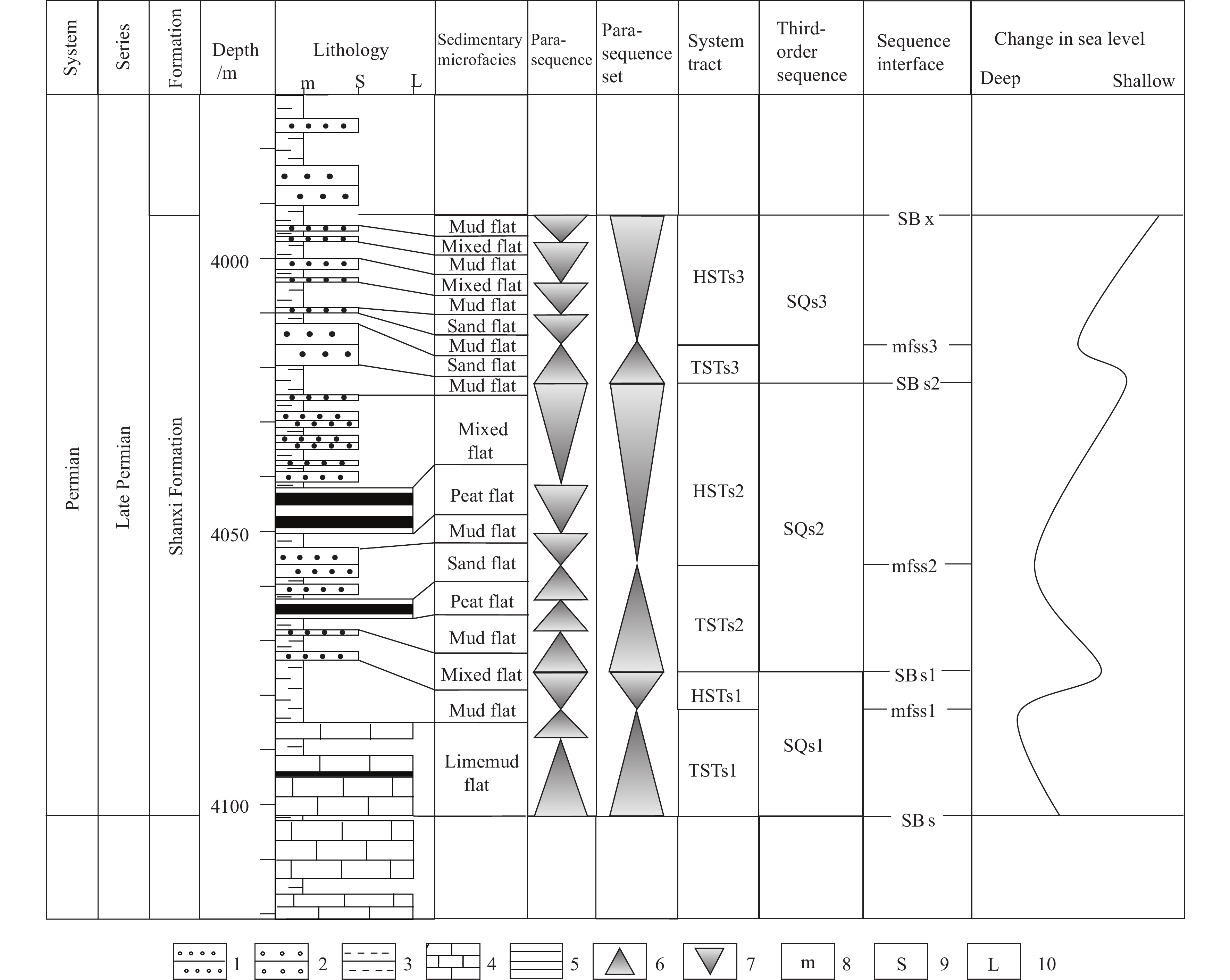
Figure 3.
Division of sequence stratigraphic framework of Shanxi Formation. 1–fine sandstone; 2–medium sandstone; 3–mudstone; 4–limestone; 5–coal seam; 6–rising of sea level; 7–dropping of sea level; 8–width of mudstone; 9–width of sandstone; 10–width of limestone.
-
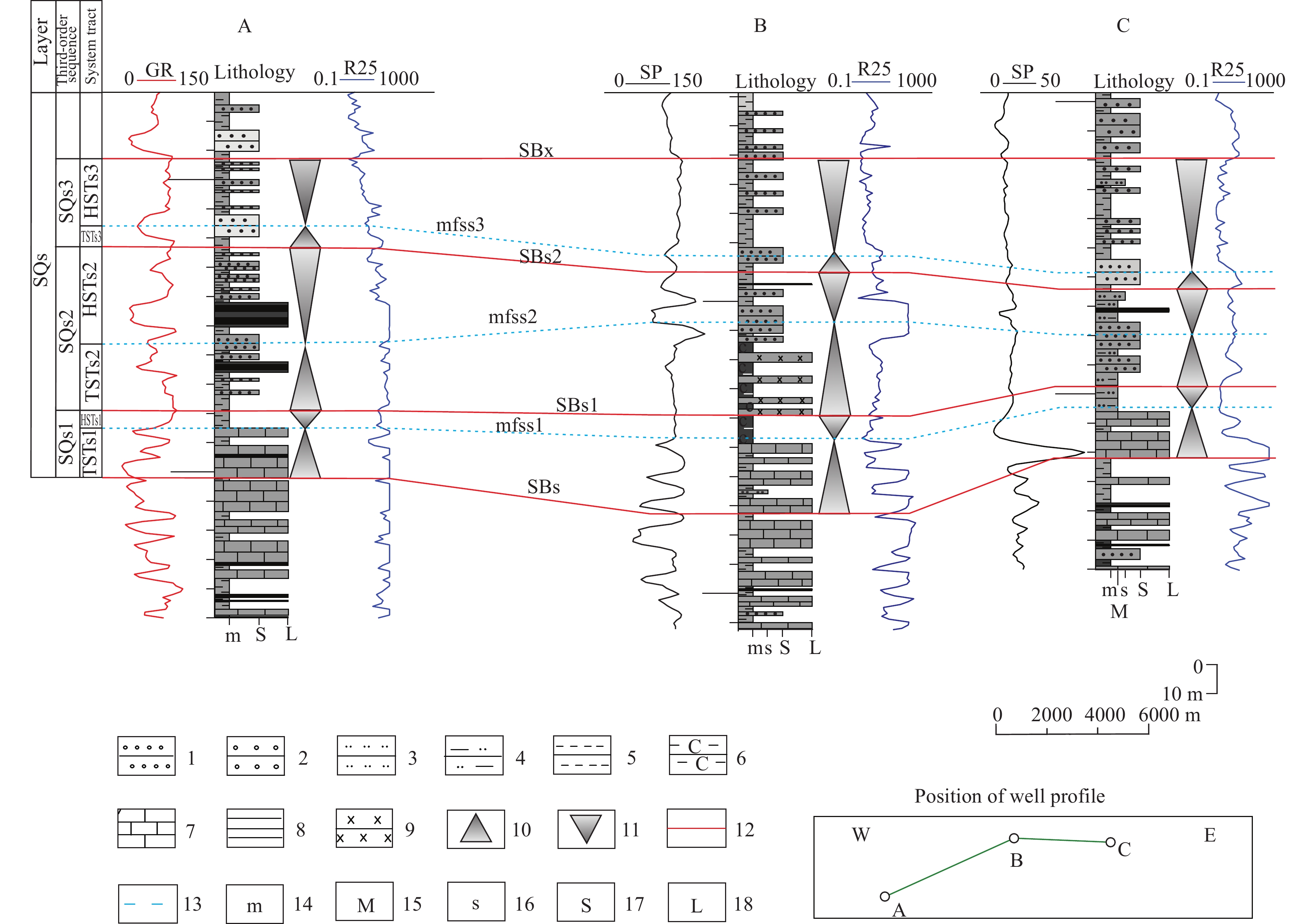
Figure 4.
Internal characteristics of sequences of Shanxi Formation (well names corresponding to those in Fig. 1). 1–fine sandstone; 2–medium sandstone; 3–siltstone; 4–silty mudstone; 5–mudstone; 6–carbonaceous mudstone; 7–limestone; 8–coal seam; 9–diabase; 10–rising of sea level; 11–dropping of sea level; 12–sequence boundary; 13–maximum flooding surface; 14–width of mudstone; 15–width of silty mudstone; 16–width of siltstone; 17–width of sandstone; 18–width of limestone.
-
Figure 5.
Sedimentary structure and lithologic characteristics of tidal flat sedimentary facies in the study area. a–Well C, P1s, 1522.66 m, parallel bedding; b–Well C, P1s, 1587.8 m, cross bedding; c–Well G, P1s, 3780.28 m, flaser bedding; d–Well G, P1s, 3776.96 m, lenticular bedding; e–Well F, P1s, 2601.68 m, carbonaceous mudstone; f–Well F, P1s, 2710.20 m, limestone.
-
Figure 6.
Distribution of sedimentary facies on well profile (W-S; well names corresponding to those in Fig. 1). 1–fine sandstone; 2–medium sandstone; 3–siltstone; 4–silty mudstone; 5–mudstone; 6–carbonaceous mudstone; 7–limestone; 8–coal seam; 9–diabase; 10–sequence boundary; 11–maximum flooding surface; 12–width of mudstone; 13–width of silty mudstone; 14–width of siltstone; 15–width of sandstone; 16–width of limestone; 17–sand flat; 18–mud flat; 19–mixed flat; 20–limemud flat; 21–peat flat; 22–intrusion area of igneous rocks.
-
Figure 7.
Distribution of sedimentary facies on well profile (N-S; well names corresponding to those in Fig. 1). 1–fine sandstone; 2–medium sandstone; 3–siltstone; 4–silty mudstone; 5–mudstone; 6–carbonaceous mudstone; 7–limestone; 8–volcanic rock; 9–coal seam; 10–diabase; 11–sequence boundary; 12–maximum flooding surface; 13–width of mudstone; 14–width of silty mudstone; 15–width of siltstone; 16–width of sandstone; 17–width of limestone; 18–sand flat; 19–mud flat; 20–mixed flat; 21–limemud flat; 22–peat flat; 23–intrusion area of igneous rocks.
-
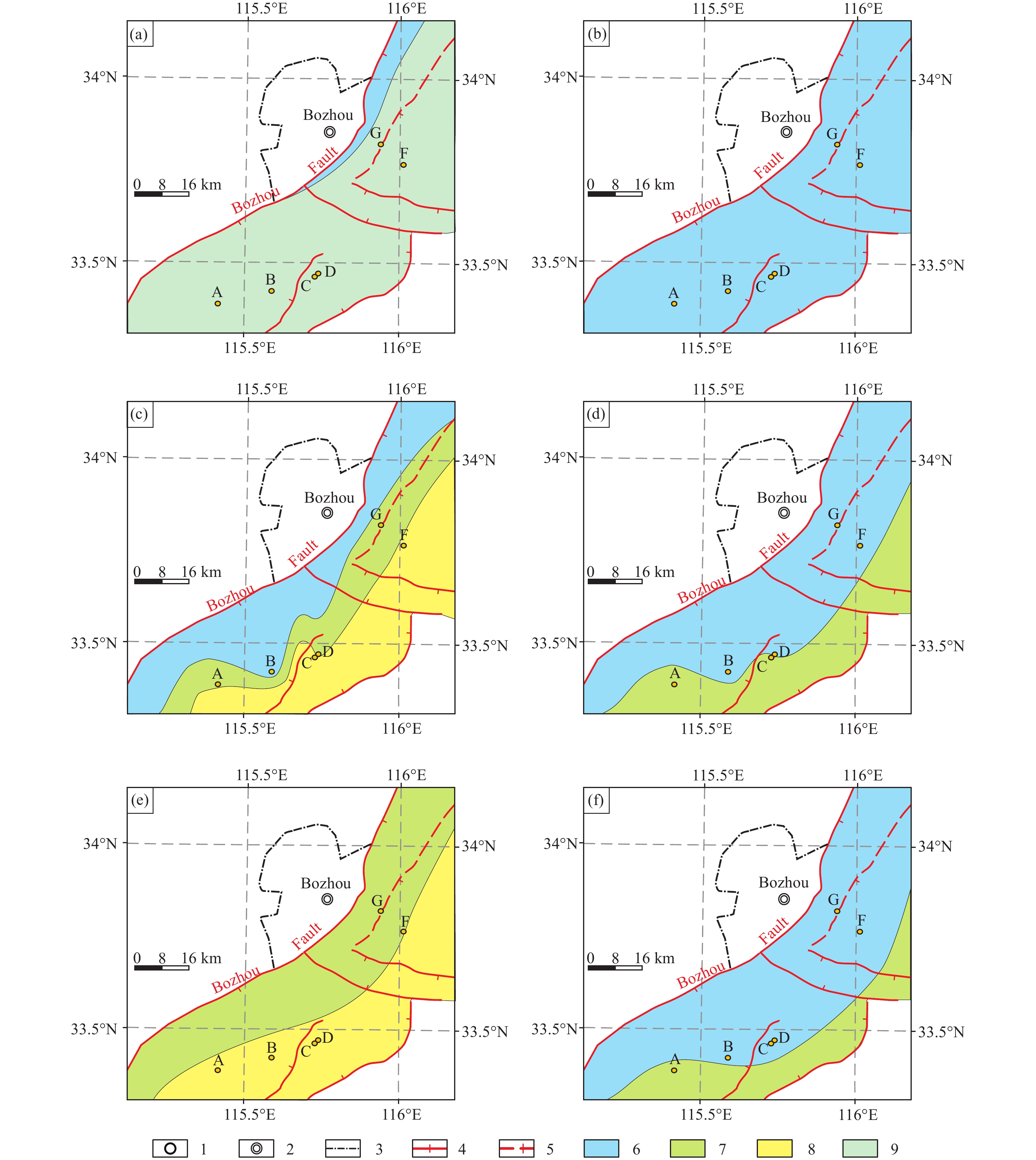
Figure 8.
Literal distribution of sedimentary facies of each system tract in Shanxi Formation. 1–well location (the alphabet A, B, C, D, F, G refers to the name of each well); 2–prefecture-level city; 3–provincial boundary; 4–normal fault; 5–reverse fault; 6–mud flat; 7–mixed flat; 8–sand flat; 9–limemud flat.
-
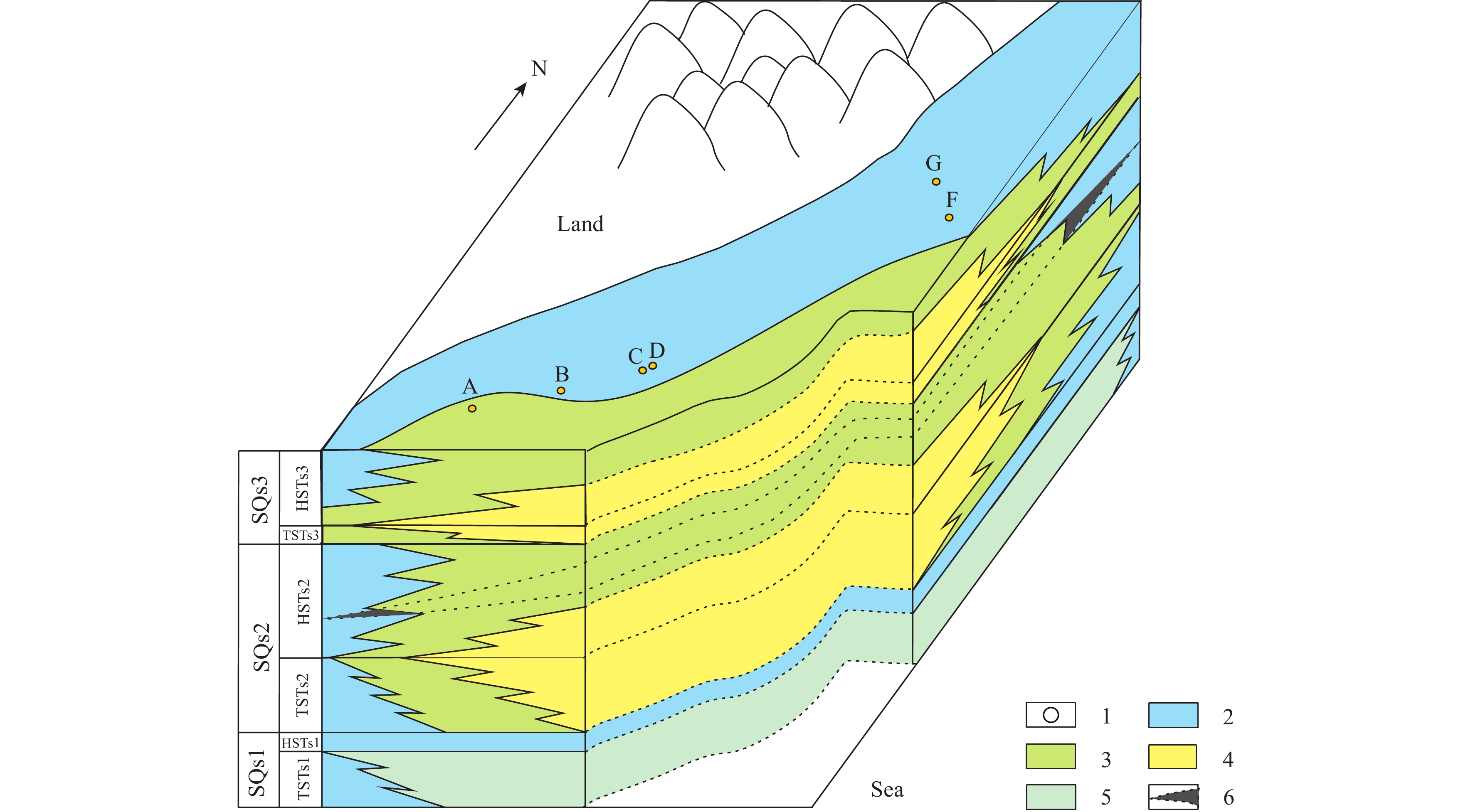
Figure 9.
Sedimentary facies model in sequence stratigraphic framework of Shanxi Formation. 1–well location; 2–mud flat; 3–mixed flat; 4–sand flat; 5–limemud flat; 6–peat flat.