
| Qingdao Institute of marine geology, China Geological Survey | Host |
| Citation: |
LIU Gang, JIN Dingjian, WU Fang, YU Kun, LI Qi, ZHANG Wenkai, WANG Jianchao. Application of airborne LiDAR to identification of underwater geomorphology and fine interpretation of faults.[J]. Marine Geology & Quaternary Geology, 2022, 42(2): 190-199. doi: 10.16562/j.cnki.0256-1492.2021061502

|
Application of airborne LiDAR to identification of underwater geomorphology and fine interpretation of faults.
-
Abstract
The airborne lidar bathymetry (ALB) is a new equipment for efficient survey of offshore seabed topography with high precision, high accuracy, high efficiency and wide operation area. By study of the high-resolution submarine topography data collected by the CZMIL Nova Ⅱ ALB system from an island in the South China Sea, it is found that the data can be used for efficient identification of geomorphic types and precise interpretation of submarine fractures, and the principles and methods adopted are very similar to the remote sensing interpretation for land structures. Through the detailed interpretation of the images acquired by lidar sounding, many seabed geomorphic types are found in the study area, for examples, the sand spit, headland, bay, ancient wave-cut platform, bank slope, fault depression, valley, submarine plain and residual fault block. The submarine landform and coastline surrounding the island are mainly controlled by fractures. Four groups of faults in NW, NNW, NNE and NEE directions are found on the seafloor, basically in consistent with the regional tectonic patterns. The extension of submarine rift system on land surface is proved by the high-resolution images acquired synchronously by the digital camera of CZMIL Nova Ⅱ system. Our experience in this survey proves that to extend the technique of remote sensing interpretation for land structures to the underwater fault interpretation offshore is a good solution to the precise detection of fault structures in coastal shallow waters.
-

-
References
[1] 赵建虎, 欧阳永忠, 王爱学. 海底地形测量技术现状及发展趋势[J]. 测绘学报, 2017, 46(10):1786-1794 doi: 10.11947/j.AGCS.2017.20170276 ZHAO Jianhu, OUYANG Yongzhong, WANG Aixue. Status and development tendency for seafloor terrain measurement technology [J]. Acta Geodaetica et Cartographica Sinica, 2017, 46(10): 1786-1794. doi: 10.11947/j.AGCS.2017.20170276 [2] 翟国君, 黄谟涛. 海洋测量技术研究进展与展望[J]. 测绘学报, 2017, 46(10):1752-1759 doi: 10.11947/j.AGCS.2017.20170309 ZHAI Guojun, HUANG Motao. The review of development of marine surveying Technology [J]. Acta Geodaetica et Cartographica Sinica, 2017, 46(10): 1752-1759. doi: 10.11947/j.AGCS.2017.20170309 [3] 马毅, 张杰, 张靖宇, 等. 浅海水深光学遥感研究进展[J]. 海洋科学进展, 2018, 36(3):331-351 doi: 10.3969/j.issn.1671-6647.2018.03.001 MA Yi, ZHANG Jie, ZHANG Jingyu, et al. Progress in shallow water depth mapping from optical remote sensing [J]. Advances in Marine Science, 2018, 36(3): 331-351. doi: 10.3969/j.issn.1671-6647.2018.03.001 [4] 韩孝辉, 薛玉龙, 刘刚. 海上风电场建设的前期地质调查研究方法[J]. 工程勘察, 2018, 46(3):29-34 HAN Xiaohui, XUE Yulong, LIU Gang. Study methods for preliminary geological survey of the construction of offshore wind farms [J]. Geotechnical Investigation & Surveying, 2018, 46(3): 29-34. [5] 孟庆生, 楚贤峰, 郭秀军, 等. 高分辨率数据处理技术在近海工程地震勘探中的应用[J]. 地球物理学进展, 2007, 22(3):1006-1010 doi: 10.3969/j.issn.1004-2903.2007.03.053 MENG Qingsheng, CHU Xianfeng, GUO Xiujun, et al. The application of high resolution seismic data processing technique in multi-channel shallow offshore engineering seismic surveys [J]. Progress in Geophysics, 2007, 22(3): 1006-1010. doi: 10.3969/j.issn.1004-2903.2007.03.053 [6] 孙运宝, 赵铁虎, 潘军, 等. 表面多次波衰减技术在渤海海峡应用效果[J]. 海洋地质与第四纪地质, 2015, 35(2):179-184 SUN Yunbao, ZHAO Tiehu, PAN Jun, et al. The application of SRME to high resolution seismic exploration in shallow sea environment [J]. Marine Geology & Quaternary Geology, 2015, 35(2): 179-184. [7] Parker H, Sinclair M. The successful application of Airborne LiDAR Bathymetry surveys using latest technology[C]//2012 Oceans-Yeosu. Yeosu, Korea (South): IEEE, 2012. [8] Feygels V, Ramnath V, Smith B, et al. Meeting the international hydrographic organization requirements for bottom feature detection using the Coastal Zone Mapping and Imaging Lidar (CZMIL)[C]//OCEANS 2016 MTS/IEEE Monterey. Monterey, CA, USA: IEEE, 2016: 1-6. [9] Pastol Y. Use of airborne LiDAR bathymetry for coastal hydrographic surveying: the French experience [J]. Journal of Coastal Research, 2011, 62(10062): 6-18. [10] Wozencraft J, Millar D. Airborne lidar and integrated technologies for coastal mapping and nautical charting [J]. Marine Technology Society Journal, 2005, 39(3): 27-35. doi: 10.4031/002533205787442440 [11] Legleiter C J, Overstreet B T, Glennie C L, et al. Evaluating the capabilities of the CASI hyperspectral imaging system and Aquarius bathymetric LiDAR for measuring channel morphology in two distinct river environments [J]. Earth Surface Processes and Landforms, 2016, 41(3): 344-363. doi: 10.1002/esp.3794 [12] Fernandez-Diaz J C, Glennie C L, Carter W E, et al. Early results of simultaneous terrain and shallow water bathymetry mapping using a single-wavelength airborne LiDAR sensor [J]. IEEE Journal of Selected Topics in Applied Earth Observations and Remote Sensing, 2014, 7(2): 623-635. doi: 10.1109/JSTARS.2013.2265255 [13] Schwarz R, Mandlburger G, Pfennigbauer M, et al. Design and evaluation of a full-wave surface and bottom-detection algorithm for LiDAR bathymetry of very shallow waters [J]. ISPRS Journal of Photogrammetry and Remote Sensing, 2019, 150: 1-10. doi: 10.1016/j.isprsjprs.2019.02.002 [14] Wright C W, Kranenburg C, Battista T A, et al. Depth calibration and validation of the experimental advanced airborne research Lidar, EAARL-B [J]. Journal of Coastal Research, 2016, 76(sp1): 4-17. [15] Kotilainen A T, Kaskela A M. Comparison of airborne LiDAR and shipboard acoustic data in complex shallow water environments: Filling in the white ribbon zone [J]. Marine Geology, 2017, 385: 250-259. doi: 10.1016/j.margeo.2017.02.005 [16] 贺岩, 胡善江, 陈卫标, 等. 国产机载双频激光雷达探测技术研究进展[J]. 激光与光电子学进展, 2018, 55(8):6-16 HE Yan, HU Shanjiang, CHEN Weibiao, et al. Research progress of domestic airborne dual-frequency technology LiDAR detection [J]. Laser & Optoelectronics Progress, 2018, 55(8): 6-16. [17] Guenther G C. Airborne lidar bathymetry digital elevation. model technologies and applications[M]//Maune M D. The DEM Users Manual. 2nd ed. Maryland: American Society for Photogrammetry and Remote Sensing, 2007: 253-320. [18] Jerlov N G. Optical Oceanography[M]. New York: Elsevier, 1968: 167-168. [19] 金鼎坚, 吴芳, 于坤, 等. 机载激光雷达测深系统大规模应用测试与评估: 以中国海岸带为例[J]. 红外与激光工程, 2020, 49(S2):20200317 JIN Dingjian, WU Fang, YU Kun, et al. Large-scale application test and evaluation of an airborne lidar bathymetry system-A case study in China’s coastal zone [J]. Infrared and Laser Engineering, 2020, 49(S2): 20200317. [20] 周成虎, 程维眀, 钱金凯. 数字地貌遥感解析与制图[M]. 北京: 科学出版社, 2009: 42-51 ZHOU Chenghu, CHENG Weiming, QIAN Jinkai. Digital Geomorphological Interpretation and Mapping from Remote Sensing[M]. Beijing: Science Press, 2009: 42-51 [21] 田明中, 程捷. 第四纪地质学与地貌学[M]. 北京: 地质出版社, 2009: 157-163 TIAN Mingzhong, CHENG Jie. Quaternary Geology and Geomorphology[M]. Beijing: Geological Publishing House, 2009: 157-163. [22] 曹超, 蔡锋, 郑勇玲, 等. 中国近海海底地形特征及剖面类型分析[J]. 中南大学学报(自然科学版), 2014, 45(2):483-494 CAO Chao, CAI Feng, ZHENG Yongling, et al. Topography characteristics and profile type of China offshore submarine [J]. Journal of Central South University (Science and Technology), 2014, 45(2): 483-494. [23] 刘以宣, 钟建强, 詹文欢. 南海及邻域新构造运动基本特征[J]. 海洋地质与第四纪地质, 1994, 14(4):1-13 LIU Yixuan, ZHONG Jianqiang, ZHAN Wenhuan. Basic characteristics of neotectonism in South China Sea and its adjacent regions [J]. Marine Geology & Quaternary Geology, 1994, 14(4): 1-13. [24] 刘瑞华, 张仲英. 海南岛的新构造运动特征[J]. 热带地理, 1989, 9(2):174-182 LIU Ruihua, ZHANG Zhongying. Characteristics of Neotectonic Movement in Hainan Island [J]. Tropical Geography, 1989, 9(2): 174-182. [25] 赵国强, 苏小宁. 基于GPS获得的中国大陆现今地壳运动速度场[J]. 地震, 2014, 34(1):97-103 doi: 10.3969/j.issn.1000-3274.2014.01.011 ZHAO Guoqiang, SU Xiaoning. Present-day crustal movement velocity field in mainland China derived from GPS observations [J]. Earthquake, 2014, 34(1): 97-103. doi: 10.3969/j.issn.1000-3274.2014.01.011 [26] 梁光河. 海南岛的成因机制研究[J]. 中国地质, 2018, 45(4):693-705 doi: 10.12029/gc20180404 LIANG Guanghe. A study of the genesis of Hainan Island [J]. Geology in China, 2018, 45(4): 693-705. doi: 10.12029/gc20180404 -
Access History
Figures(8)
Tables(2)

Export File
Citation
LIU Gang, JIN Dingjian, WU Fang, YU Kun, LI Qi, ZHANG Wenkai, WANG Jianchao. Application of airborne LiDAR to identification of underwater geomorphology and fine interpretation of faults.[J]. Marine Geology & Quaternary Geology, 2022, 42(2): 190-199. doi: 10.16562/j.cnki.0256-1492.2021061502
Format
Content
 DownLoad:


-
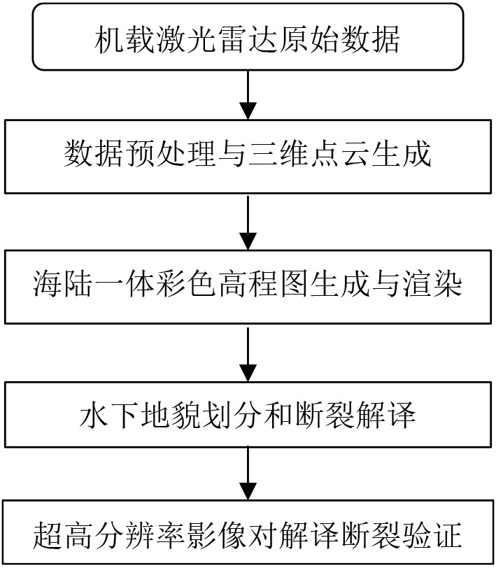
Figure 1.
Flowchart of data processing and remote sensing interpretation
-
Figure 2.
Map of geomorphology, with major faults and profile locations map based on lidar elevation rendering images
-
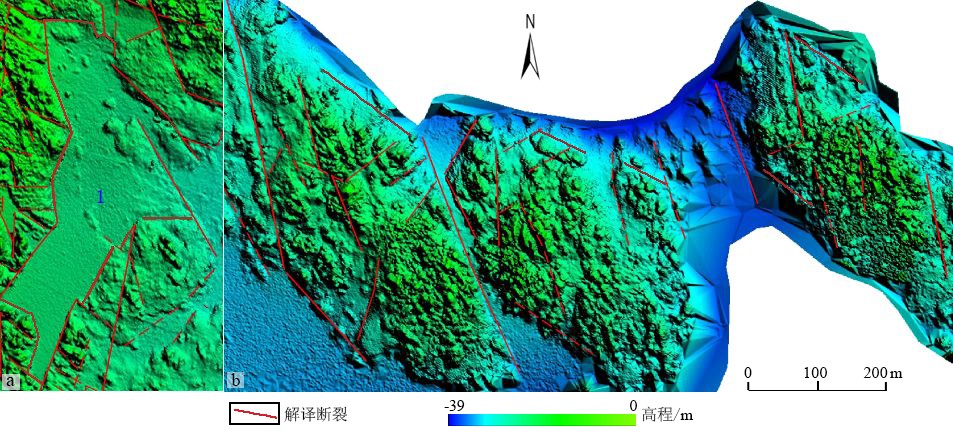
Figure 3.
Locally enlarged fault depression No. 1 (a) and rhombic monadnock (b) lidar sounding rendered images
-
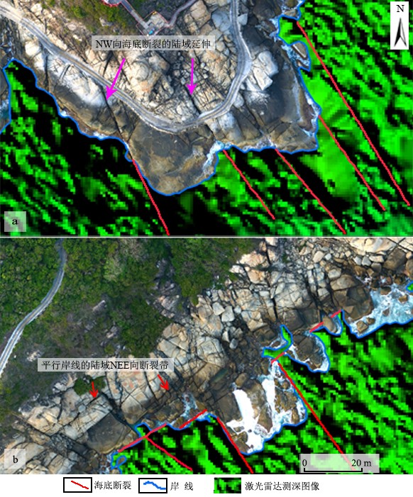
Figure 4.
Image characteristics of the fracture system on ultra-high resolution images of land area and marine lidar images
-
Figure 5.
Submarine faults interpreted by lidar rendering image, partly enlarged
-
Figure 6.
Lidar and ultra-high resolution images of the fault zone along the southwest shoreline
-
Figure 7.
Ultra-high resolution image of fault scarps tending in NE,NEE and NW directions
-
Figure 8.
Kinematic characteristics of NW strike fractures