
| Qingdao Institute of marine geology, China Geological Survey | Host |
| Citation: |
SONG Weiyu, LIU Yanan, HU Bangqi, YANG Huiliang, CHEN Jiangxin, JIA Chao, LIU Sen. Landform classification for the Philippine Sea based on DEM data[J]. Marine Geology & Quaternary Geology, 2021, 41(1): 192-198. doi: 10.16562/j.cnki.0256-1492.2020111501

|
Landform classification for the Philippine Sea based on DEM data
-
Abstract
Submarine geomorphology plays significant roles in marine environmental and engineering studies, and the deep sea is specially complex in geomorphology. Based on the existing norms, standards and regional tectonic evolution characteristics, this paper takes the Philippine sea as the research object for study of deep sea geoenvironment. Quantitative standards are proposed and six different geomorphic units are identified, which include seamounts, hills, submarine rifts, mountain valleys, intermontane depressions, and intermontane basins. Based on DEM, ArcGIS is used to extract critical geomorphological factors such as elevation, slope, slope change and relief of land surface. Following the classification, the study area is quantitatively divided into six geomorphic units. Controlled by the tectonic stresses in different periods, the west part and the east part of the survey area show significant difference in tectonic strikes. The oceanic ridges in the west are arranged in a near-EW pattern, and the hills in the east are in a near-NS direction. Ridges are narrower in the west. Large-scale geomorphic units, such as seamounts and intermontane basins are often controlled by strong geological processes, such as magmatic, hydrothermal and tectonic activities. Facts have proved that this research is helpful to submarine landform classification and the study of their genesis. It can also contribute more to the formulation of relevant standards and specifications for deep sea geomorphological studies.
-

-
References
[1] 李炳元, 潘保田, 韩嘉福. 中国陆地基本地貌类型及其划分指标探讨[J]. 第四纪研究, 2008, 28(4):535-543 doi: 10.3321/j.issn:1001-7410.2008.04.004 LI Bingyuan, PAN Baotian, HAN Jiafu. Basic terrestrial geomorphological types in China and their circumscriptions [J]. Quaternary Sciences, 2008, 28(4): 535-543. doi: 10.3321/j.issn:1001-7410.2008.04.004 [2] 张斌, 李广雪, 黄继锋. 菲律宾海构造地貌特征[J]. 海洋地质与第四纪地质, 2014, 34(2):79-88 ZHANG Bin, LI Guangxue, HUANG Jifeng. The tectonic geomorphology of the Philippine Sea [J]. Marine Geology & Quaternary Geology, 2014, 34(2): 79-88. [3] 李四海, 李艳雯, 樊妙, 等. 基于海底地貌分类的海底地名通名分类体系研究[J]. 海洋通报, 2013, 32(2):160-163 doi: 10.11840/j.issn.1001-6392.2013.02.006 LI Sihai, LI Yanwen, FAN Miao, et al. Research on the classification system for the generic names of undersea features [J]. Marine Science Bulletin, 2013, 32(2): 160-163. doi: 10.11840/j.issn.1001-6392.2013.02.006 [4] 中华人民共和国国家质量监督检疫总局, 中国国家标准化管理委员会. GB/T 12763.10-2007 海洋调查规范 第10部分: 海底地形地貌调查[S]. 北京: 中国标准出版社, 2008. General Administration of Quality Supervision and Quarantine of the People's Republic of China. GB/T 12763.10-2007 Specification for oceanographic survey - Part 10: Submarine topography and geomorphology[S]. Beijing: China Standards Press, 2008. [5] 李学杰, 王哲, 姚永坚, 等. 西太平洋边缘构造特征及其演化[J]. 中国地质, 2017, 44(6):1102-1114 LI Xuejie, WANG Zhe, YAO Yongjian, et al. The tectonic features and evolution of the west Pacific margin [J]. Geology in China, 2017, 44(6): 1102-1114. [6] 中华人民共和国国土资源部. DZ/T 0255-2014 海洋区域地质调查规范(1: 50000)[S]. 北京: 中国标准出版社, 2014. Ministry of Land and Resources of the People's Republic of China. DZ/T 0255-2014 Specifications for Regional Marine Geological Survey (scale: 1: 50 000)[S]. Beijing: China Standards Press, 2014. [7] 中华人民共和国国土资源部. DZ/T 0247-2009 1: 1 000 000海洋区域地质调查规范[S]. 北京: 中国标准出版社, 2009. Ministry of Land and Resources of the People's Republic of China. DZ/T 0247-2009 Specifications for regional marine geological survey (scale: 1: 1 000 000)[S]. Beijing: China Standards Press, 2009. [8] 中华人民共和国国土资源部. DZ/T 0256-2014 海洋区域地质调查规范(1: 250 000)[S]. 北京: 中国标准出版社, 2014. Ministry of Land and Resources of the People's Republic of China. DZ/T 0256-2014 Specifications for regional marine geological survey (scale: 1: 250 000)[S]. Beijing: China Standards Press, 2014. [9] 林美华, 李乃胜. 菲律宾海周边的深海沟地貌[J]. 海洋科学, 1998(6):29-31 LIN Meihua, LI Naisheng The surrounding trench geomorphology of Philippine sea [J]. Marine Sciences, 1998(6): 29-31. [10] 林美华, 李乃胜. 西菲律宾海中央断裂带地貌学研究[J]. 海洋地质与第四纪地质, 1999, 19(1):39-44 LIN Meihua, LI Naisheng. Geomorphic study of the central rift zone in the west Philippine sea [J]. Marine Geology & Quaternary Geology, 1999, 19(1): 39-44. [11] 李常珍, 李乃胜, 林美华. 菲律宾海的地势特征[J]. 海洋科学, 2000, 24(6):47-51 doi: 10.3969/j.issn.1000-3096.2000.06.014 LI Changzhen, LI Naisheng, LIN Meihua. Terrain features of the Philippine Sea [J]. Marine Sciences, 2000, 24(6): 47-51. doi: 10.3969/j.issn.1000-3096.2000.06.014 [12] Takahashi N, Suyehiro K, Shinohara M. Implications from the seismic crustal structure of the northern Izu-Bonin arc [J]. The Island Arc, 1998, 7(3): 383-394. [13] Hall R, Ali J R, Anderson C D, et al. Origin and motion history of the Philippine Sea Plate [J]. Tectonophysics, 1995, 251(1-4): 229-250. [14] Hall R, Ali J R, Anderson C D. Cenozoic motion of the Philippine Sea Plate: Palaeomagnetic evidence from eastern Indonesia [J]. Tectonics, 1995, 14(5): 1117-1132. doi: 10.1029/95TC01694 [15] Hall R. Cenozoic geological and plate tectonic evolution of SE Asia and the SW Pacific: computer-based reconstructions, model and animations [J]. Journal of Asian Earth Sciences, 2002, 20(4): 353-431. [16] ARK J O, HORI T, KANEDA Y. Seismotectonic implications of the Kyushu-Palau Ridge subducting beneath the westernmost Nankai Forearc [J]. Earth, Planets and Space, 2009, 61(8): 1013-1018. doi: 10.1186/BF03352951 [17] NISHIZAWA A, KANEDA K, KATAGIRI Y, et al. Variation in crustal structure along the Kyushu Palau Ridge at 15-21 N on the Philippine Sea plate based on seismic refraction profiles [J]. Earth, Planets and Space, 2007, 59(6): e17-e20. doi: 10.1186/BF03352711 [18] Yamashita M, Tsuru T, Takahashi N, et al. Fault configuration produced by initial arc rifting in the Parece Vela Basin as deduced from seismic reflection data [J]. The Island Arc, 2007, 16(3): 338-347. doi: 10.1111/j.1440-1738.2007.00594.x [19] 郭华东, 王长林. 全天候全天时三维航天遥感技术: 介绍航天飞机雷达地形测图计划[J]. 遥感信息, 2000(1):47-48 doi: 10.3969/j.issn.1000-3177.2000.01.015 GUO Huadong, WANG Changlin. All weather and all day 3D space remote sensing technology: instruction of shuttle radar topography mission [J]. Remote Sensing Information, 2000(1): 47-48. doi: 10.3969/j.issn.1000-3177.2000.01.015 [20] Aster G Validation Team: METI/ERSDAC, NASAJLPDAAC, USGS/EROS, 2009: ASTER Global DEM Validation, Summary Report. 2010. [21] IHO. Standardization of Undersea Feature Names: Guidelines Proposal form Terminology[M]. 4th ed. Monaco: International Hydrographic Organisation and Intergovernmental Oceanographic Commission, 2008. [22] Tarduno J, Bunge H P, Sleep N, et al. The bent hawaiian-emperor hotspot track: inheriting the mantle wind [J]. Science, 2009, 324(5923): 50-53. doi: 10.1126/science.1161256 [23] 尚鲁宁, 陈磊, 张训华, 等. 冲绳海槽南部海底热液活动区地形地貌特征及成因分析[J]. 海洋地质与第四纪地质, 2019, 39(4):12-22 SHANG Luning, CHEN Lei, ZHANG Xunhua, et al. Topographic features of the hydrothermal field and their genetic mechanisms in southern Okinawa Trough [J]. Marine Geology & Quaternary Geology, 2019, 39(4): 12-22. -
Access History

Figures(3)
Tables(3)

Export File
Citation
SONG Weiyu, LIU Yanan, HU Bangqi, YANG Huiliang, CHEN Jiangxin, JIA Chao, LIU Sen. Landform classification for the Philippine Sea based on DEM data[J]. Marine Geology & Quaternary Geology, 2021, 41(1): 192-198. doi: 10.16562/j.cnki.0256-1492.2020111501
Format
Content
 DownLoad:
-
Figure 1.
Submarine topographic and geomorphological map of the Philippine Sea plate and the location map of study area
-
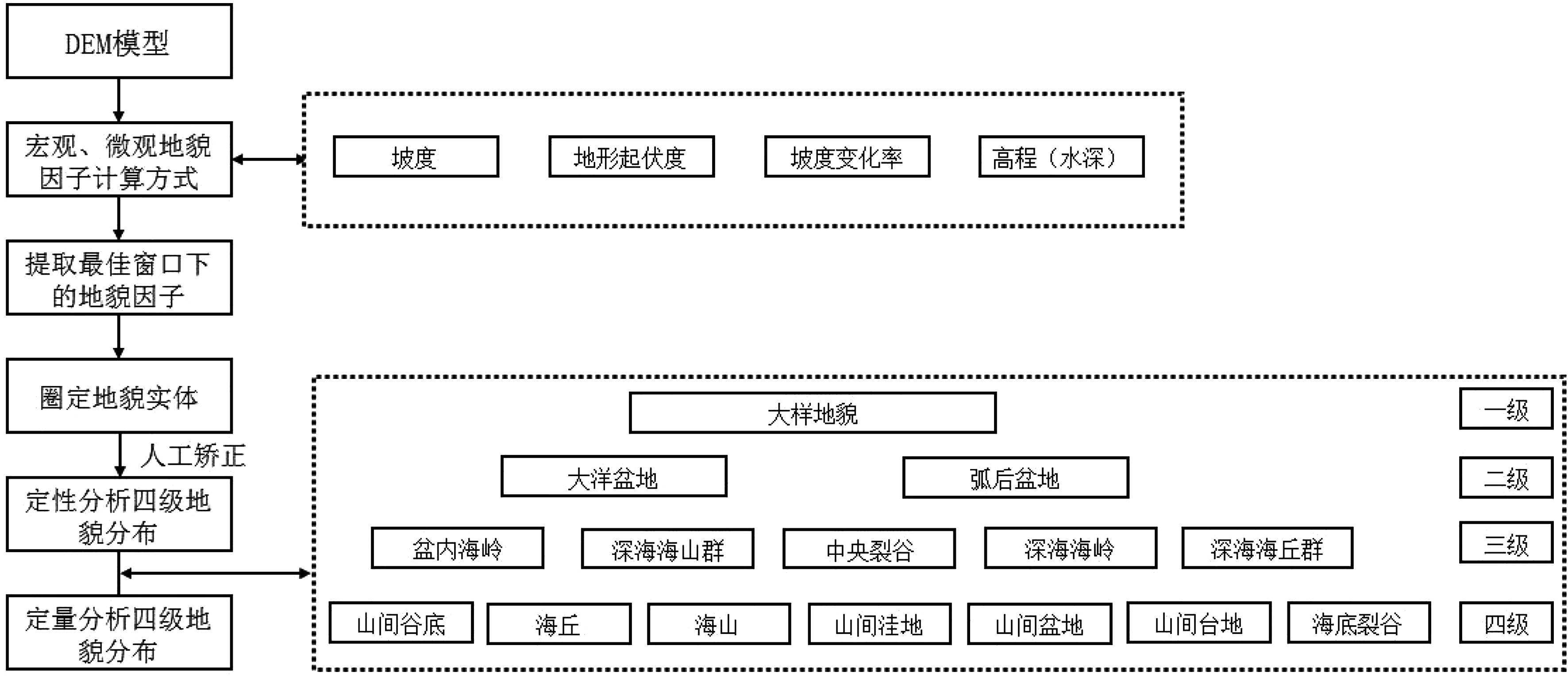
Figure 2.
Technical flowchart for classification of seabed geomorphology based on DEM data
-
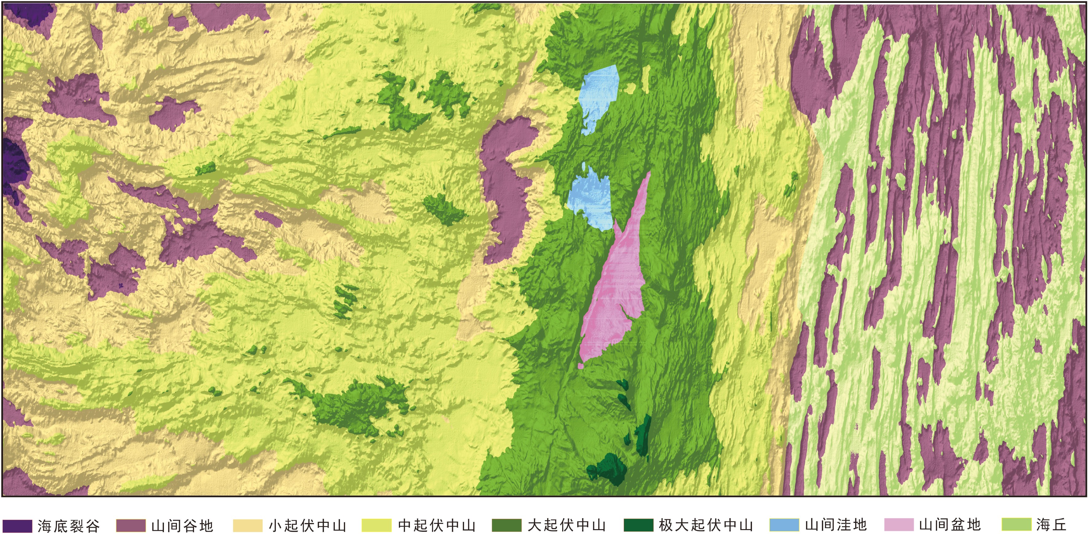
Figure 3.
Geomorphologic map of the study area