
| Qingdao Institute of marine geology, China Geological Survey | Host |
| Citation: |
FENG Xiangzi, ZHU Yousheng. Investigation of gravity flow deposits on the Lingshui slope of the northern South China Sea[J]. Marine Geology & Quaternary Geology, 2020, 40(5): 25-35. doi: 10.16562/j.cnki.0256-1492.2019123001

|
Investigation of gravity flow deposits on the Lingshui slope of the northern South China Sea
-
Abstract
Deep-water environment is rather complex. Within the shallow part of the environment, there occur various gravity flow deposits, that become new challenges to the design, construction and operation of underwater facilities. The landslides on scale of hundreds of meters can be identified by 2D/3D digital seismic survey, but the recognition of gravity flow depositional system on the shallow seabed, which is concerned by marine engineers, is limited. Taking the Lingshui block in the north of the South China Sea as an example, this paper discussed the formation and distribution models of shallow gravity flow deposits in the deep sea bottom with the results of MBES backscattering on board, the sub-bottom profile data carried by the Autonomous Underwater Vehicle (AUV), combined with the data of Jumbo Piston Corer (JPC) sampling and AMS14C dating. The results show that the MBES backscatter result can accurately identify the region of gravity flow deposition and the changes of surface sediments, the Sub-bottom profiler carried by AUV can accurately identify the vertical differences of strata, and JPC sampling can obtain the gravity flow deposits as well as their physical and mechanical parameters. The comprehensive analysis of the above data founded the basis to accurately identify, study and recognize the present situation of the gravity flow depositional system. The latest two periods of gravity flow deposition in the study area occurred about 5.5 ka and 45 ka ago, respectively. Generally, the gravity flow is caused by the activity of submarine canyon on the upper slope. In the latest gravity flow event, turbidity current deposition and MTDS deposition took place successively, and the MTDS deposition produced obvious erosion to the underlying strata. In the design and construction of underwater structures in the gravity flow active area, special attention should be paid to the change of terrain slope caused by gravity flow deposition and the difference of soil composition in the stratum, which may affect the installation and maintenance of underwater facilities.
-
Keywords:
- backscatter /
- gravity flow deposition /
- turbidity /
- deep-water sedimentary model
-

-
References
[1] Heezen B C, Ewing W M. Turbidity currents and submarine slumps and the 1929 Grand Banks (Newfoundland) earthquake [J]. American Journal Science Series, 1952, 250: 849-873. doi: 10.2475/ajs.250.12.849 [2] Parker G, Garcia M, Fukushima Y, et al. Experiments on turbidity currents over an erodible bed [J]. Journal of Hydraulic Research, 1987, 25: 123-147. doi: 10.1080/00221688709499292 [3] Garcia M. Depositional turbidity currents laden with poorly sorted sediment [J]. Journal of Hydraulic Engineering, 1994, 120: 1 240-1 263. doi: 10.1061/(ASCE)0733-9429(1994)120:11(1240) [4] Huang H, Imran J, Pirmez C. Numerical modeling of poorly sorted depositional turbidity currents [J]. Journal of Geophysical Research, 2007, 112: 1-15. [5] Bouma A H, Normark W R, Barnes N E. Submarine Fans and Related Turbidite Systems [M]. New York: Springer Verlag, 1985: 351. [6] Talling P J, Masson D G, Sumner E J, et al. Subaqueous sediment density flows: Depositional processes and deposit types [J]. Sedimentology, 2012, 59(7): 1 937-2 003. doi: 10.1111/j.1365-3091.2012.01353.x [7] Bouma A H. Sedimentology of Some Flysch Deposits: A Graphic Approach to Facies Interpretation[M]. Amsterdam: Elsevier, 1962: 168. [8] 秦志亮. 南海北部陆坡块体搬运沉积体系的沉积过程、分布及成因研究[D]. 中国科学院研究生院. 2012. QIN Zhiliang. Study on the sedimentary process, distribution and genesis of the transport sedimentary system on the northern continental slope of the South China Sea [D]. Graduate School of Chinese Academy of Sciences. 2012. [9] 邵磊, 李学杰, 耿建华, 等. 南海北部深水底流沉积作用[J]. 中国科学: D辑: 地球科学, 2007(6):771-777 SHAOLei, LI Xuejie, GENG Jianhua, et al. Deepwater undercurrent sedimentation in the northern South China Sea [J]. Chinese Science: part D: Geoscience, 2007(6): 771-777. [10] 王大伟, 吴时国, 董冬冬, 等. 琼东南盆地第四纪块体搬运体系的地震特征[J]. 海洋地质与第四纪地质, 2009(3):69-74 WANG Dawei, WU Shiguo, DONG Dongdong, et al. Seismic characteristics of Quaternary block transport system in Qiongdongnan Basin [J]. Marine Geology and Quaternary Geology, 2009(3): 69-74. [11] 王俊勤, 张广旭, 陈端新, 等. 琼东南盆地陵水研究区海底地质灾害类型、分布和成因机制[J]. 海洋地质与第四纪地质, 2019(4):87-95 WANG Junqin, Zhang GUANGXU, CHEN Duanxin, et al. Types, distribution and genetic mechanism of submarine geological disasters in Lingshui study area of Qiongdongnan Basin [J]. Marine Geology and Quaternary Geology, 2019(4): 87-95. [12] 王大伟, 吴时国, 秦志亮, 等. 南海陆坡大型块体搬运体系的结构与识别特征[J]. 海洋地质与第四纪地质, 2009(5):65-72 WANG Dawei, WU Shiguo, QIN Zhiliang, et al. Structure and identification characteristics of large block transport system on the continental slope of the South China Sea [J]. Marine Geology and Quaternary Geology, 2009(5): 65-72. [13] 袁圣强, 吴时国, 赵宗举, 等. 南海北部陆坡深水区沉积物输送模式探讨[J]. 海洋地质与第四纪地质, 2010(4):39-48 YUAN Shengqiang, WU Shiguo, ZHAO Zongju, et al. Discussion on sediment transport model in deep water area of northern continental slope of South China Sea [J]. Marine geology and Quaternary geology, 2010(4): 39-48. [14] 张娜, 姜涛, 张道军. 琼东南盆地海底地形地貌特征及其对深水沉积的控制[J]. 海洋地质与第四纪地质, 2012(5):27-33 ZHANG Na, JIANG Tao, ZHANG Daojun. Seafloor topography and geomorphology in Qiongdongnan Basin and its control on deep-water sedimentation [J]. Marine Geology and Quaternary Geology, 2012(5): 27-33. [15] 庞雄, 陈长民, 朱明. 深水沉积研究前缘问题[J]. 地质论评, 2007(1):36-42 doi: 10.3321/j.issn:0371-5736.2007.01.006 PANG Xiong, CHEN Changmin, ZHU Ming. Frontier problems in the study of deep-water sedimentation [J]. A review of geology, 2007(1): 36-42. doi: 10.3321/j.issn:0371-5736.2007.01.006 [16] 徐景平. 海底浊流研究百年回顾[J]. 中国海洋大学学报: 自然科学版, 2014(10):98-105 XU Jingping. A hundred-year review of the study of submarine turbidity current [J]. Journal of Ocean University of China: natural Science Edition, 2014(10): 98-105. [17] 姜辉. 浊流沉积的动力学机制与响应[J]. 石油与天然气地质, 2010, 8(8):428-435 JIANG Hui. Dynamic mechanism and response of turbidity current deposition [J]. Petroleum and natural gas geology, 2010, 8(8): 428-435. [18] 李利阳. 浊流沉积研究的新进展: 鲍马序列、海底扇的重新审视[J]. 沉积与特提斯地质, 2015(4):106-112 doi: 10.3969/j.issn.1009-3850.2015.04.015 LI Liyang. New progress in the study of turbidite deposits: re-examination of Baoma sequence and subsea fan [J]. Sedimentation and Tethys geology, 2015(4): 106-112. doi: 10.3969/j.issn.1009-3850.2015.04.015 [19] 孙国桐. 深水重力流沉积研究进展[J]. 地质科技情报, 2015(3):30-36 SUN Guotong. Research progress of gravity flow deposition in deep water [J]. Geological science and technology information, 2015(3): 30-36. [20] 梁建设, 田兵, 王琪, 等. 深水沉积理论研究现状、存在问题及发展趋势[J]. 天然气地球科学, 2017(10):1488-1496 LIANG Jian, TIAN Bing, WANG Qi, et al. Research status, existing problems and development trend of deepwater sedimentation theory [J]. Natural Gas Geoscience, 2017(10): 1488-1496. [21] Laval A, Cremer M, Beghin P, et al. Density surges: Two-dimensional experiments [J]. Sedimentology, 2010, 35(1): 73-84. [22] MarrJ G, Harff P A, Shanmugam G, et al. Experiments on subaqueous sandy gravity flows: The role of clay and water content in flow dynamics and depositional structures [J]. Geo-logical Society of America Bulletin, 2001, 113(11): 1377-1386. doi: 10.1130/0016-7606(2001)113<1377:EOSSGF>2.0.CO;2 [23] Yin M, Rui Y. Laboratory study on submarine debris flow [J]. Marine Georesources & Geotechnology, 2018, 36(8): 950-958. -
Access History
Figures(11)
Tables(1)

Export File
Citation
FENG Xiangzi, ZHU Yousheng. Investigation of gravity flow deposits on the Lingshui slope of the northern South China Sea[J]. Marine Geology & Quaternary Geology, 2020, 40(5): 25-35. doi: 10.16562/j.cnki.0256-1492.2019123001
Format
Content
 DownLoad:


-
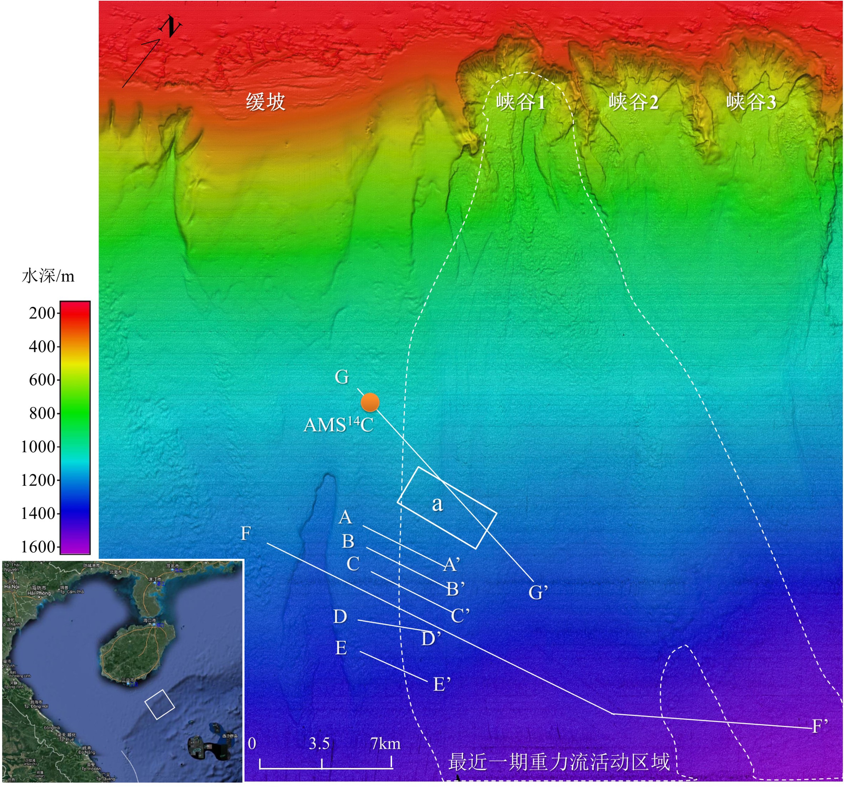
Figure 1.
Bathymetric map showing the survey area
-
Figure 2.
Estimating the age of gravity flow by AMS 14C dating(At G-G’ of Fig.2)
-
Figure 3.
The last MTDs sediment according to terrain recognition(at area a of Fig.1)
-
Figure 4.
Slope map/SBP profile— boundary between turbidite deposits and normal deposits
-
Figure 5.
The Backscatter intensity in the lower slope area
-
Figure 6.
Contrast of backscatter map (left) and sub-bottom profile (right)
-
Figure 7.
Sub-bottom profile − recent turbidity and MTDs deposits(At E-E’ of Fig.1)
-
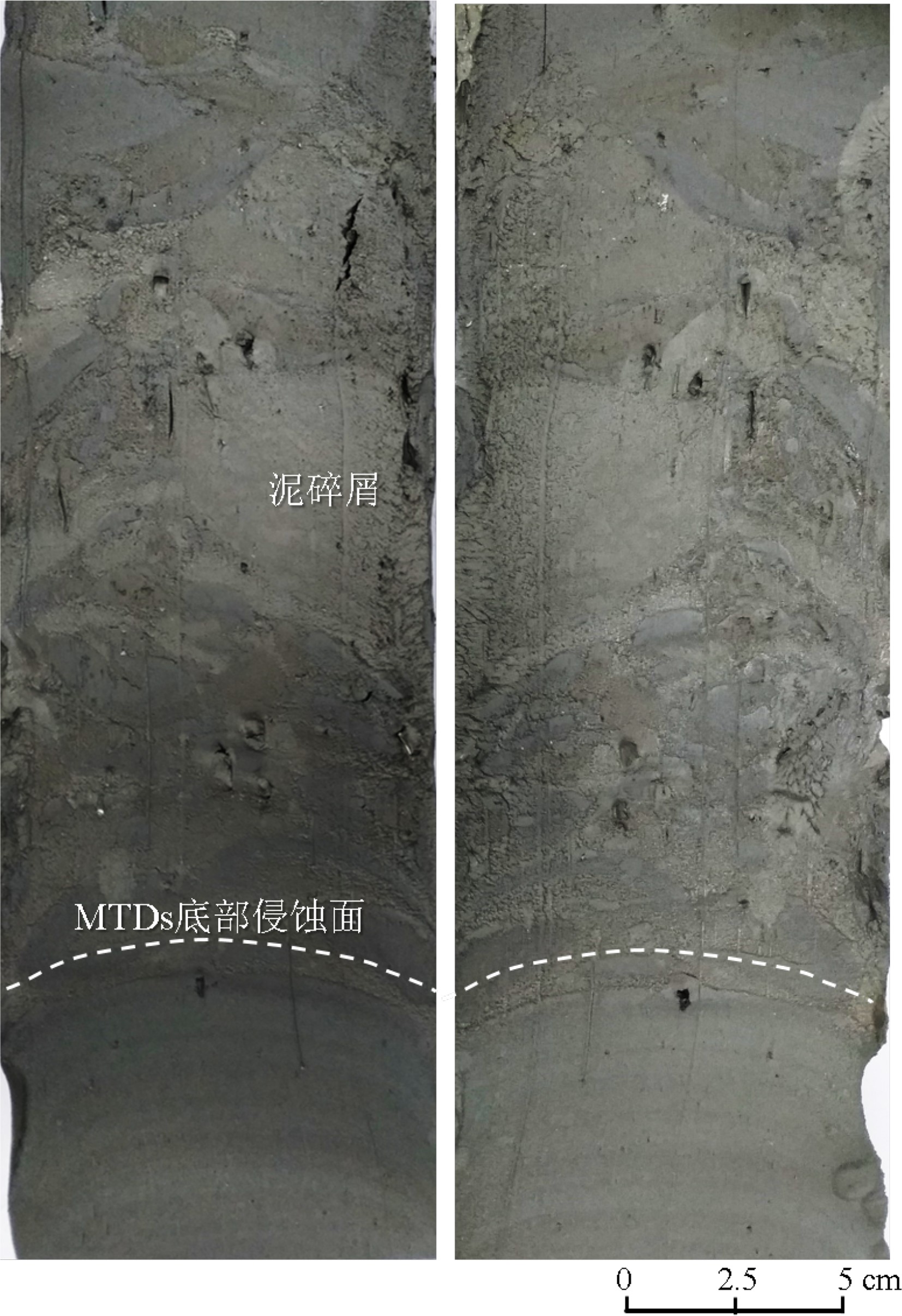
Figure 8.
MTDs sediment sample by JPC sampling
-
Figure 9.
Sub-bottom profile— Turbidities in the seabed depressions(At D-D’ of Fig.1)
-
Figure 10.
Turbidity and MTDs sedimentary models
-
Figure 11.
3D Illumination map and W-E sub-bottom profile in survey area(at F-F’ of Fig.1)