
| China Geological Environment Monitoring Institute, China Geological Disaster Prevention Engineering Industry Association | Host |
| Citation: |
MA Mingming, WU Shangqian, XIE Meng, TONG Peng, YUAN Xiaobo. Extraction of eucalyptus trees along railway lines based on decision tree classification and identification of potential landslides: A case study along Guangxi section of the Guizhou—Guangxi Railway[J]. The Chinese Journal of Geological Hazard and Control, 2025, 36(1): 37-45. doi: 10.16031/j.cnki.issn.1003-8035.202305047

|
Extraction of eucalyptus trees along railway lines based on decision tree classification and identification of potential landslides: A case study along Guangxi section of the Guizhou—Guangxi Railway
-
Abstract
The unique growth characteristics of eucalyptus can result in the depletion of soil nutrient and fertilizers, leading to land degradation and geological hazards like landslides. The Guangxi region in China has suitable climatic conditions, and numerous eucalyptus are strategically planted along railway lines, posing the risk of potential landslides. To proactively identify potential landslides along railway lines, this study takes the Guangxi section of the Guizhou-Guangxi high-speed railway as a case study. Based on Landsat 9 OLI, GF-7 imagery, and DEM data, a decision tree classification algorithm is employed to extract the planting areas of eucalyptus within a 1 km buffer zone along the railway. Then, comprehensive analysis incorporating terrain and landforms factors is conducted to identify potential landslides hazards. The research findings show that: 1) compared to other methods, the decision tree classification algorithm conducted in this study improves the classification accuracy, with an overall average classification accuracy of 87.19% and an average Kappa coefficient of 0.80, indicating that this method can effectively extract the range of eucalyptus in the study area; 2) A large number of eucalyptus are planted along the Guangxi section of the Guinan high-speed railway, with eucalyptus distributed in patches in hilly areas. The eucalyptus planting area within the 1 km buffer zone along the railway is approximately 14.48 km2; 3) The planting of eucalyptus in the study area has a certain impact on the bridges, emban kments, and tunnel entrances of the railway. A total of 33 potential landslides were identified in this study, with an accuracy rate of 86.84% through field verification. The above method can effectively extract the planting range of eucalyptus along the railway line, and combined with geological factors, it can proactively identify potential landslides, enhancing the safety of railway operation.
-

-
References
[1] 杨晓燕,熊炀,宫雪,等. 亚热带地区主要阔叶用材树种的非生物胁迫研究进展[J]. 西南林业大学学报(自然科学),2023,43(3):191 − 204. [YANG Xiaoyan,XIONG Yang,GONG Xue,et al. Advances in abiotic stress of main broad-leaved timber species in subtropical regions[J]. Journal of Southwest Forestry University (Natural Sciences),2023,43(3):191 − 204. (in Chinese with English abstract)] YANG Xiaoyan, XIONG Yang, GONG Xue, et al. Advances in abiotic stress of main broad-leaved timber species in subtropical regions[J]. Journal of Southwest Forestry University (Natural Sciences), 2023, 43(3): 191 − 204. (in Chinese with English abstract) [2] 王会利,吴秦展,兰文明,等. 多代连栽桉树人工林林下植被和土壤物理性状的变化[J]. 中南林业科技大学学报,2023,43(2):1 − 9. [WANG Huili,WU Qinzhan,LAN Wenming,et al. Dynamics of understory vegetation and soil physical properties in eucalyptus plantations of different generations[J]. Journal of Central South University of Forestry & Technology,2023,43(2):1 − 9. (in Chinese with English abstract)] WANG Huili, WU Qinzhan, LAN Wenming, et al. Dynamics of understory vegetation and soil physical properties in eucalyptus plantations of different generations[J]. Journal of Central South University of Forestry & Technology, 2023, 43(2): 1 − 9. (in Chinese with English abstract) [3] 舒成博,沈影利,刘刚,等. 南方山区典型小流域桉树人工林种植对水土流失的影响[J]. 应用生态学报,2023,34(4):1015 − 1023. [SHU Chengbo,SHEN Yingli,LIU Gang,et al. Impacts of Eucalyptus plantation on soil and water losses in a typical small watershed in mountainous area of southern China[J]. Chinese Journal of Applied Ecology,2023,34(4):1015 − 1023. (in Chinese with English abstract)] SHU Chengbo, SHEN Yingli, LIU Gang, et al. Impacts of Eucalyptus plantation on soil and water losses in a typical small watershed in mountainous area of southern China[J]. Chinese Journal of Applied Ecology, 2023, 34(4): 1015 − 1023. (in Chinese with English abstract) [4] 韦向向,王晟强,唐健,等. 桂南红壤区多代连栽桉树对土壤肥力的影响[J]. 西南林业大学学报(自然科学),2023,43(4):81 − 88. [WEI Xiangxiang,WANG Shengqiang,TANG Jian,et al. Effects of multi-generation continuous planting on soil fertility quality of eucalyptus plantation in red soil area of southern Guangxi[J]. Journal of Southwest Forestry University (Natural Sciences),2023,43(4):81 − 88. (in Chinese with English abstract)] WEI Xiangxiang, WANG Shengqiang, TANG Jian, et al. Effects of multi-generation continuous planting on soil fertility quality of eucalyptus plantation in red soil area of southern Guangxi[J]. Journal of Southwest Forestry University (Natural Sciences), 2023, 43(4): 81 − 88. (in Chinese with English abstract) [5] 苏轶君. 基于高分遥感影像的泥石流潜在形成区识别方法探讨[J]. 中国地质灾害与防治学报,2020,31(5):22 − 31. [SU Yijun. Probing into the techniques recognizing potential debris flow formation regions[J]. The Chinese Journal of Geological Hazard and Control,2020,31(5):22 − 31. (in Chinese with English abstract)] SU Yijun. Probing into the techniques recognizing potential debris flow formation regions[J]. The Chinese Journal of Geological Hazard and Control, 2020, 31(5): 22 − 31. (in Chinese with English abstract) [6] 李天驰,王道儒,赵亮,等. 基于Landsat8遥感数据的西沙群岛永乐环礁底质分类与变化分析[J]. 自然资源遥感,2023,35(2):70 − 79. [LI Tianchi,WANG Daoru,ZHAO Liang,et al. Classification and change analysis of the substrate of the Yongle Atoll in the Xisha Islands based on Landsat8 remote sensing data[J]. Remote Sensing for Natural Resources,2023,35(2):70 − 79. (in Chinese with English abstract)] LI Tianchi, WANG Daoru, ZHAO Liang, et al. Classification and change analysis of the substrate of the Yongle Atoll in the Xisha Islands based on Landsat8 remote sensing data[J]. Remote Sensing for Natural Resources, 2023, 35(2): 70 − 79. (in Chinese with English abstract) [7] HOLTGRAVE A K,LOBERT F,ERASMI S,et al. Grassland mowing event detection using combined optical,SAR,and weather time series[J]. Remote Sensing of Environment,2023,295:113680. doi: 10.1016/j.rse.2023.113680 [8] 闫涵,张毅. 利用GF-6影像结合国土“三调”开展西部地区县域自然资源调查[J]. 自然资源遥感,2023,35(2):277 − 286. [YAN Han,ZHANG Yi. County-level natural resource survey in western China based on both GF-6 images and the third national land resource survey results[J]. Remote Sensing for Natural Resources,2023,35(2):277 − 286. (in Chinese with English abstract)] YAN Han, ZHANG Yi. County-level natural resource survey in western China based on both GF-6 images and the third national land resource survey results[J]. Remote Sensing for Natural Resources, 2023, 35(2): 277 − 286. (in Chinese with English abstract) [9] 卢献健,黄俞惠,晏红波,等. 基于GEE平台广西桉树快速提取研究[J]. 林业资源管理,2019(5):52 − 60. [LU Xianjian,HUANG Yuhui,YAN Hongbo,et al. Study on rapid extraction of eucalyptus vegetation information in Guangxi based on GEE[J]. Forest Resources Management,2019(5):52 − 60. (in Chinese with English abstract)] LU Xianjian, HUANG Yuhui, YAN Hongbo, et al. Study on rapid extraction of eucalyptus vegetation information in Guangxi based on GEE[J]. Forest Resources Management, 2019(5): 52 − 60. (in Chinese with English abstract) [10] 王子彦,任超,梁月吉,等. 基于高分六号红边特征的面向对象桉树人工林信息提取[J]. 测绘通报,2021(6):6 − 11. [WANG Ziyan,REN Chao,LIANG Yueji,et al. Object-oriented eucalyptus plantation forest information extraction based on the red-edge feature of GF-6[J]. Bulletin of Surveying and Mapping,2021(6):6 − 11. (in Chinese with English abstract)] WANG Ziyan, REN Chao, LIANG Yueji, et al. Object-oriented eucalyptus plantation forest information extraction based on the red-edge feature of GF-6[J]. Bulletin of Surveying and Mapping, 2021(6): 6 − 11. (in Chinese with English abstract) [11] 陈瑞波,朱宁宁,梅树红,等. 广西桉树和马尾松单木胸径/冠幅-树高模型构建[J]. 测绘与空间地理信息,2022,45(7):70 − 73. [CHEN Ruibo,ZHU Ningning,MEI Shuhong,et al. Individual diameter-height and crown-height prediction models for pinus massoniana and eucalyptus in Guangxi[J]. Geomatics & Spatial Information Technology,2022,45(7):70 − 73. (in Chinese with English abstract)] CHEN Ruibo, ZHU Ningning, MEI Shuhong, et al. Individual diameter-height and crown-height prediction models for pinus massoniana and eucalyptus in Guangxi[J]. Geomatics & Spatial Information Technology, 2022, 45(7): 70 − 73. (in Chinese with English abstract) [12] 白仙富,杨志全,罗伟东,等. 基于GIS和多变量决策树的地震滑坡道路中断风险应急评估模型[J]. 地震研究,2023,46(3):343 − 353. [BAI Xianfu,YANG Zhiquan,LUO Weidong,et al. An emergency evaluation approach to road disruption risk influenced by earthquake-induced landslide using GIS and multivariate decision tree[J]. Journal of Seismological Research,2023,46(3):343 − 353. (in Chinese with English abstract)] BAI Xianfu, YANG Zhiquan, LUO Weidong, et al. An emergency evaluation approach to road disruption risk influenced by earthquake-induced landslide using GIS and multivariate decision tree[J]. Journal of Seismological Research, 2023, 46(3): 343 − 353. (in Chinese with English abstract) [13] SIMS D A,GAMON J A. Relationships between leaf pigment content and spectral reflectance across a wide range of species,leaf structures and developmental stages[J]. Remote Sensing of Environment,2002,81(2/3):337 − 354. [14] 敖登,杨佳慧,丁维婷,等. 54种植被指数研究进展综述[J]. 安徽农业科学,2023,51(1):13 − 21. [AO Deng,YANG Jiahui,DING Weiting,et al. Review of 54 vegetation indices[J]. Journal of Anhui Agricultural Sciences,2023,51(1):13 − 21. (in Chinese with Englishabstract)] AO Deng, YANG Jiahui, DING Weiting, et al. Review of 54 vegetation indices[J]. Journal of Anhui Agricultural Sciences, 2023, 51(1): 13 − 21. (in Chinese with Englishabstract) [15] 周智勇. 基于Landsat遥感影像的围场县植被覆盖时空格局变化[J]. 水文地质工程地质,2020,47(6):81 − 90. [ZHOU Zhiyong. Change in temporal-spatial pattern of vegetation coverage in Weichang County based on Landsat remote sensing image[J]. Hydrogeology & Engineering Geology,2020,47(6):81 − 90. (in Chinese with English abstract)] ZHOU Zhiyong. Change in temporal-spatial pattern of vegetation coverage in Weichang County based on Landsat remote sensing image[J]. Hydrogeology & Engineering Geology, 2020, 47(6): 81 − 90. (in Chinese with English abstract) [16] 戴强玉,徐勇,赵纯,等. 四川盆地植被EVI动态变化及其驱动机制[J]. 中国环境科学,2023,43(8):4292 − 4304. [DAI Qiangyu,XU Yong,ZHAO Chun,et al. Dynamic variation of vegetation EVI and its driving mechanism in the Sichuan Basin[J]. China Environmental Science,2023,43(8):4292 − 4304. (in Chinese with English abstract)] DAI Qiangyu, XU Yong, ZHAO Chun, et al. Dynamic variation of vegetation EVI and its driving mechanism in the Sichuan Basin[J]. China Environmental Science, 2023, 43(8): 4292 − 4304. (in Chinese with English abstract) [17] 梁博明,刘新,郝媛媛,等. 基于5种植被指数的荒漠区植被生物量提取研究[J]. 干旱区研究,2023,40(4):647 − 654. [LIANG Boming,LIU Xin,HAO Yuanyuan,et al. Extraction of desert vegetation information based on five vegetation indices[J]. Arid Zone Research,2023,40(4):647 − 654. (in Chinese with English abstract)] LIANG Boming, LIU Xin, HAO Yuanyuan, et al. Extraction of desert vegetation information based on five vegetation indices[J]. Arid Zone Research, 2023, 40(4): 647 − 654. (in Chinese with English abstract) [18] 董震,杨贵军,孙林,等. 多层离散各向异性辐射传输模型在玉米叶面积指数垂直分布反演中的应用[J]. 浙江大学学报(农业与生命科学版),2021,47(4):439 − 450. [DONG Zhen,YANG Guijun,SUN Lin,et al. Application of multi-layer discrete anisotropic radiative transfer model in vertical distribution inversion of maize leaf area index[J]. Journal of Zhejiang University (Agriculture and Life Sciences),2021,47(4):439 − 450. (in Chinese with English abstract)] DONG Zhen, YANG Guijun, SUN Lin, et al. Application of multi-layer discrete anisotropic radiative transfer model in vertical distribution inversion of maize leaf area index[J]. Journal of Zhejiang University (Agriculture and Life Sciences), 2021, 47(4): 439 − 450. (in Chinese with English abstract) [19] 赵威成,马福义,吕利娜,等. 基于DVI的像元二分模型反演植被覆盖度研究[J]. 黑龙江科技大学学报,2020,30(2):125 − 128. [ZHAO Weicheng,MA Fuyi,LYU Lina,et al. Study on inversion of FVC based on DVI pixel dichotomous model[J]. Journal of Heilongjiang University of Science and Technology,2020,30(2):125 − 128. (in Chinese with English abstract)] ZHAO Weicheng, MA Fuyi, LYU Lina, et al. Study on inversion of FVC based on DVI pixel dichotomous model[J]. Journal of Heilongjiang University of Science and Technology, 2020, 30(2): 125 − 128. (in Chinese with English abstract) [20] 王江伟,齐虎啸,余成群,等. 藏北高原高寒草甸植被生产力对冷暖季放牧的响应[J]. 遥感技术与应用,2023,38(1):90 − 96. [WANG Jiangwei,QI Huxiao,YU Chengqun,et al. Response of plant production to cold-season and warm-season grazing in alpine grasslands of the northern Xizang Plateau[J]. Remote Sensing Technology and Application,2023,38(1):90 − 96. (in Chinese with English abstract)] WANG Jiangwei, QI Huxiao, YU Chengqun, et al. Response of plant production to cold-season and warm-season grazing in alpine grasslands of the northern Xizang Plateau[J]. Remote Sensing Technology and Application, 2023, 38(1): 90 − 96. (in Chinese with English abstract) [21] 曹庆安,涂梨平,冷鹏. 改正的盖度-坡度-OSAVI反演法的江西省草地资源盖度预测[J]. 测绘通报,2023(1):141 − 144. [CAO Qing’an,TU Liping,LENG Peng. Prediction of grassland coverage in Jiangxi Province by corrected coverage-slope-OSAVI inversion method[J]. Bulletin of Surveying and Mapping,2023(1):141 − 144. (in Chinese with English abstract)] CAO Qing’an, TU Liping, LENG Peng. Prediction of grassland coverage in Jiangxi Province by corrected coverage-slope-OSAVI inversion method[J]. Bulletin of Surveying and Mapping, 2023(1): 141 − 144. (in Chinese with English abstract) [22] 文诗雅,朱大明,付志涛,等. 基于遥感生态指数的城市生态环境质量评价——以贵阳市为例[J]. 国土与自然资源研究,2023(2):51 − 54. [WEN Shiya,ZHU Daming,FU Zhitao,et al. Ecological environment quality evaluation of Guiyang City based on remote sensing ecological index[J]. Territory & Natural Resources Study,2023(2):51 − 54. (in Chinese with English abstract)] WEN Shiya, ZHU Daming, FU Zhitao, et al. Ecological environment quality evaluation of Guiyang City based on remote sensing ecological index[J]. Territory & Natural Resources Study, 2023(2): 51 − 54. (in Chinese with English abstract) [23] MA Yuanli,LI Yang,XU Jianjun. Confidence intervals for high-dimensional multi-task regression[J]. JUSTC,2023,53(4):403. doi: 10.52396/JUSTC-2022-0115 [24] 张梦涵,魏进,卞海丁. 基于机器学习的边坡稳定性分析方法——以国内618个边坡为例[J]. 地球科学与环境学报,2022,44(6):1083 − 1095. [ZHANG Menghan,WEI Jin,BIAN Haiding. Slope stability analysis method based on machine learning:Taking 618 slopes in China as examples[J]. Journal of Earth Sciences and Environment,2022,44(6):1083 − 1095. (in Chinese with English abstract)] ZHANG Menghan, WEI Jin, BIAN Haiding. Slope stability analysis method based on machine learning: Taking 618 slopes in China as examples[J]. Journal of Earth Sciences and Environment, 2022, 44(6): 1083 − 1095. (in Chinese with English abstract) [25] 郭斌,贾燕,梁彧,等. 四川宝轮服务区降雨型滑坡活动过程分析[J]. 中国地质灾害与防治学报,2020,31(4):45 − 51. [GUO Bin,JIA Yan,LIANG Yu,et al. Analysis on process of rainfall-induced landslide in Baolun service area’Sichuan Province[J]. The Chinese Journal of Geological Hazard and Control,2020,31(4):45 − 51. (in Chinese with English abstract)] GUO Bin, JIA Yan, LIANG Yu, et al. Analysis on process of rainfall-induced landslide in Baolun service area’Sichuan Province[J]. The Chinese Journal of Geological Hazard and Control, 2020, 31(4): 45 − 51. (in Chinese with English abstract) [26] 李文娟,邵海. 基于遥感影像多尺度分割与地质因子评价的滑坡易发性区划[J]. 中国地质灾害与防治学报,2021,32(2):94 − 99. [LI Wenjuan,SHAO Hai. Landslide susceptibility assessment based on multi-scale segmentation of remote sensing and geological factor evaluation[J]. The Chinese Journal of Geological Hazard and Control,2021,32(2):94 − 99. (in Chinese with English abstract)] LI Wenjuan, SHAO Hai. Landslide susceptibility assessment based on multi-scale segmentation of remote sensing and geological factor evaluation[J]. The Chinese Journal of Geological Hazard and Control, 2021, 32(2): 94 − 99. (in Chinese with English abstract) [27] 白光顺,杨雪梅,朱杰勇,等. 基于证据权法的昆明五华区地质灾害易发性评价[J]. 中国地质灾害与防治学报,2022,33(5):128 − 138. [BAI Guangshun,YANG Xuemei,ZHU Jieyong,et al. Susceptibility assessment of geological hazards in Wuhua District of Kuming,China using the weight evidence method[J]. The Chinese Journal of Geological Hazard and Control,2022,33(5):128 − 138. (in Chinese with English abstract)] BAI Guangshun, YANG Xuemei, ZHU Jieyong, et al. Susceptibility assessment of geological hazards in Wuhua District of Kuming, China using the weight evidence method[J]. The Chinese Journal of Geological Hazard and Control, 2022, 33(5): 128 − 138. (in Chinese with English abstract) [28] 解明礼,巨能攀,刘蕴琨,等. 崩塌滑坡地质灾害风险排序方法研究[J]. 水文地质工程地质,2021,48(5):184 − 192. [XIE Mingli,JU Nengpan,LIU Yunkun,et al. A study of the risk ranking method of landslides and collapses[J]. Hydrogeology & Engineering Geology,2021,48(5):184 − 192. (in Chinese with English abstract)] XIE Mingli, JU Nengpan, LIU Yunkun, et al. A study of the risk ranking method of landslides and collapses[J]. Hydrogeology & Engineering Geology, 2021, 48(5): 184 − 192. (in Chinese with English abstract) -
Access History

Figures(7)
Tables(5)

Export File
Citation
MA Mingming, WU Shangqian, XIE Meng, TONG Peng, YUAN Xiaobo. Extraction of eucalyptus trees along railway lines based on decision tree classification and identification of potential landslides: A case study along Guangxi section of the Guizhou—Guangxi Railway[J]. The Chinese Journal of Geological Hazard and Control, 2025, 36(1): 37-45. doi: 10.16031/j.cnki.issn.1003-8035.202305047
Format
Content
 DownLoad:


-
Figure 1.
Distribution map of the study area and images
-
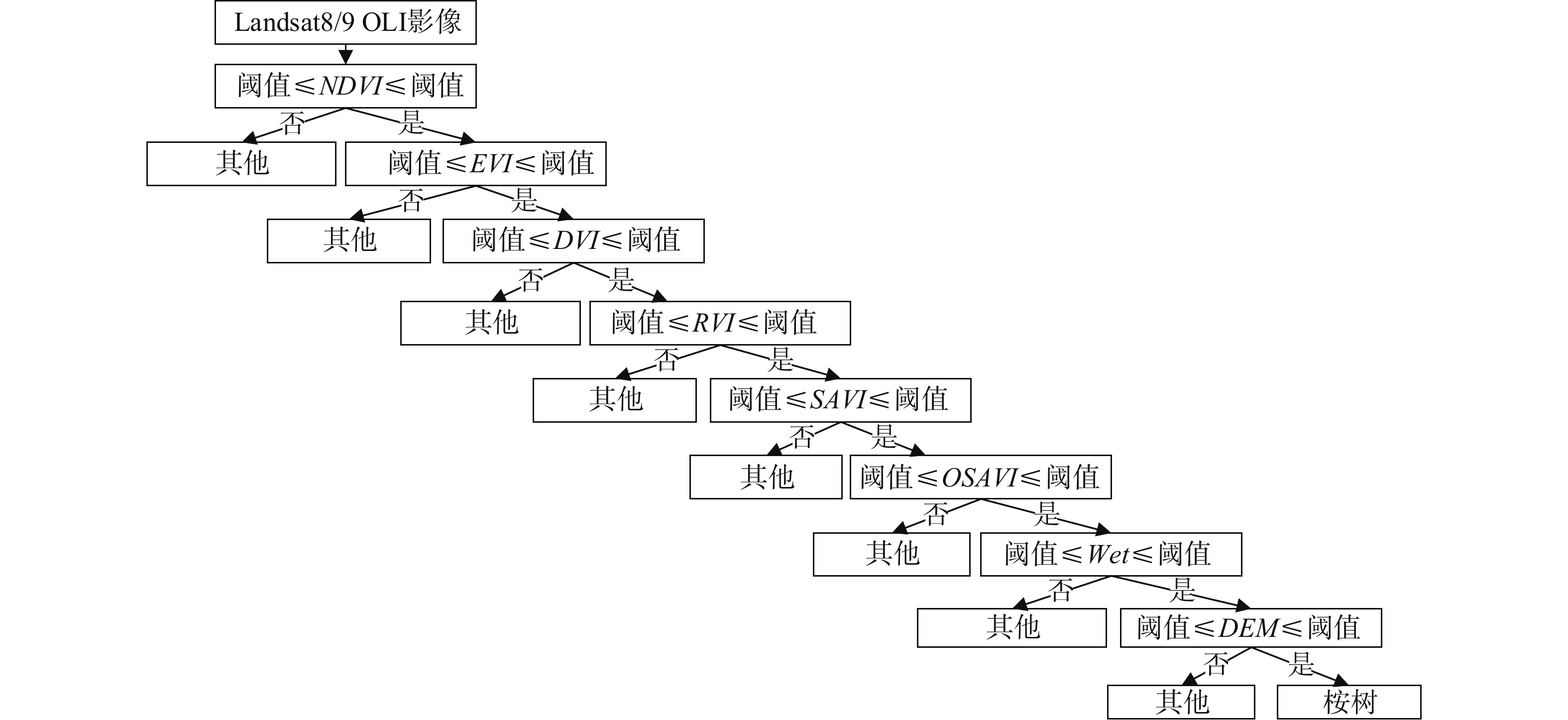
Figure 2.
Decision tree diagram
-
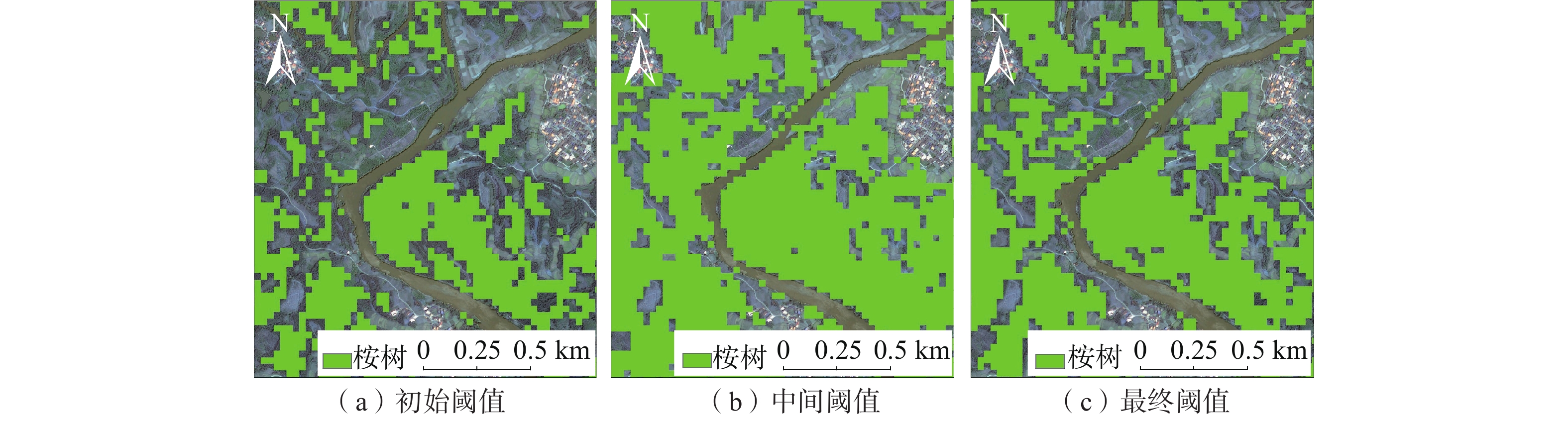
Figure 3.
Local area classification results during threshold optimization process
-
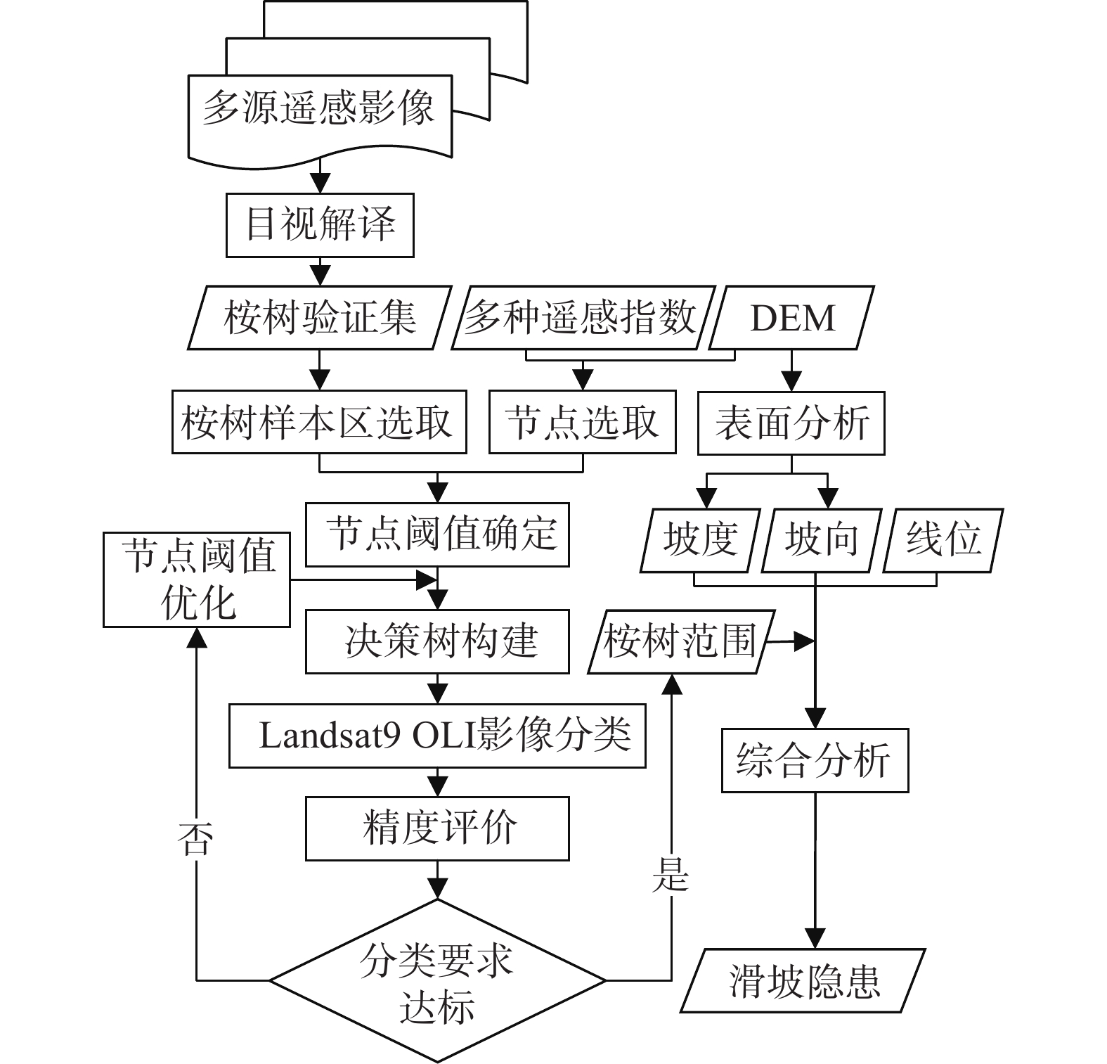
Figure 4.
Overall flow chart
-
Figure 5.
Feature map of eucalyptus in GF-7 image
-
Figure 6.
Classification results of three methods in Landsat9 OLI image on April 9, 2022
-
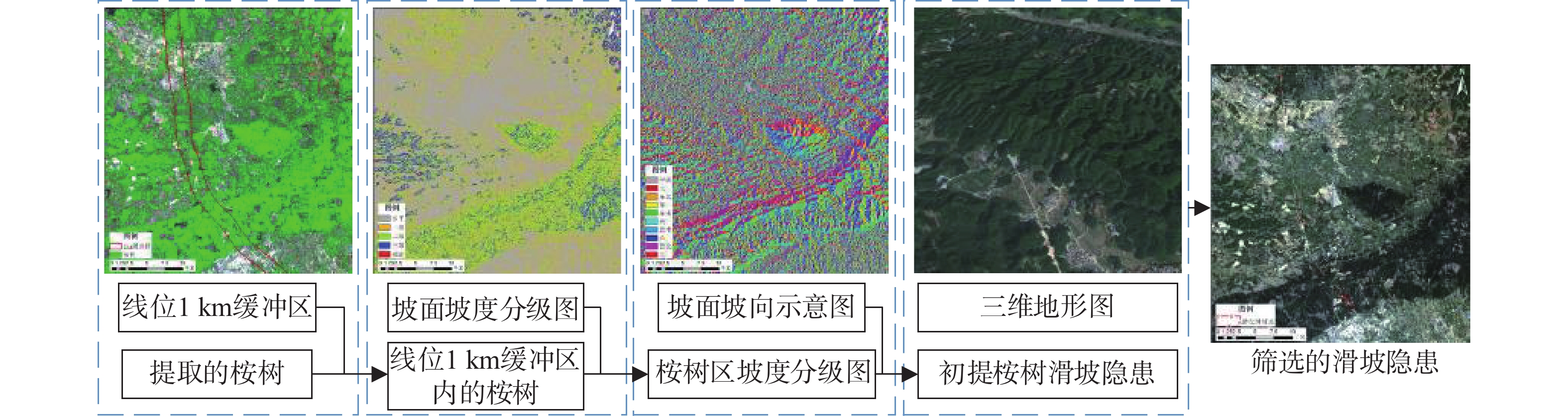
Figure 7.
Extraction process of potential landslides