
| China Geological Environment Monitoring Institute, China Geological Disaster Prevention Engineering Industry Association | Host |
| Citation: |
CHENG Qiang, ZHOU Xingquan, ZHANG Xiao. Kinematics and mechanism analysis of Tangjiawan landslide on the Xinshi—Jinyang Highway in Sichuan Province[J]. The Chinese Journal of Geological Hazard and Control, 2025, 36(1): 46-56. doi: 10.16031/j.cnki.issn.1003-8035.202303027

|
Kinematics and mechanism analysis of Tangjiawan landslide on the Xinshi—Jinyang Highway in Sichuan Province
-
Abstract
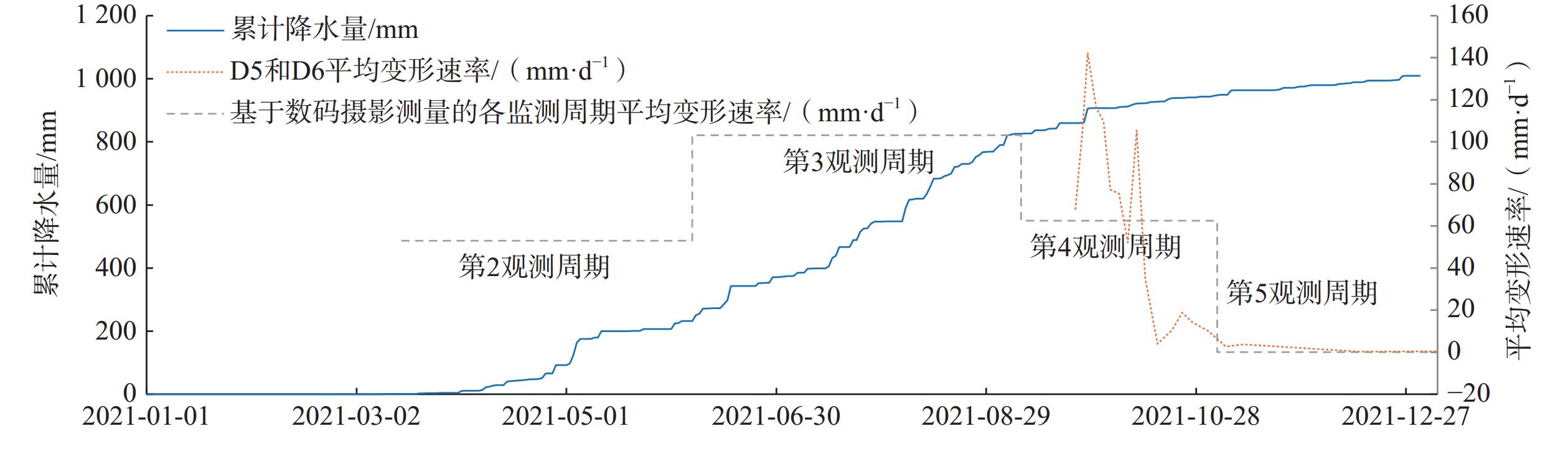
Studying the kinematics of landslides is crucial for analyzing failure mechanism and designing remedial measures. This paper focuses on the Tandjiawan landslide that occurred during a highway construction. Five periods of high-resolution digital orthophoto maps (DOM) were generated using unmanned aerial vehicle (UAV)- based photogrammetry, spanning both pre- and post- landslide conditions. Two successive UAV orthophotos were treated as observation periods, and corresponding features were identified in both images to establish monitoring points. Furthermore, two-dimensional displacement vectors were then computed by comparing orthographic images from each observation period based on these corresponding features. The analysis of kinematics and failure mechanism were conducted in conjunction with geological surveys and inclinometer measurements. The findings reveal that there was no significant deformation in the landslide area before the engineering construction of the highway (1st observation period). After construction, during the second observation period (March 15, 2021, to June 6, 2021), the third observation period (June 6, 2021, to September 8, 2021), and the fourth observation period (September 8, 2021, to November 3, 2021), the average deformation rates of the main sliding area of the landslide were 53.0 mm/day, 103.2 mm/day and 62.5 mm/day, respectively. By the fifth observation period (November 3, 2021, to January 3, 2022), the deformation rates had trended towards zero. The deposition of spoil at the rear of the landslide during the second observation period was the direct triggering factor, and rainfall facilitated the development of landslide deformation. As the rainy season ended and the front-end loading increased, the landslide deformation rate gradually decreased. This paper demonstrates that multi-period UAV photogrammetry can provide spatiotemporal surface deformation information for landslide areas, serving as an effective tools for landslide deformation monitoring.
-
Keywords:
- UAV images /
- photogrammetry /
- landslide /
- kinematics
-

-
References
[1] 贾会会,薛建志,郭利召,等. “空天地”一体化技术在采空区形变监测中的应用[J]. 中国地质灾害与防治学报,2023,34(3):69 − 82. [JIA Huihui,XUE Jianzhi,GUO Lizhao,et al. Application of combined space,arial and ground based multiple technologies in deformation monitoring of mining areas[J]. The Chinese Journal of Geological Hazard and Control,2023,34(3):69 − 82. (in Chinese with English abstract)] doi: 10.16031/j.cnki.issn.1003-8035.202202015 JIA Huihui, XUE Jianzhi, GUO Lizhao, et al. Application of combined space, arial and ground based multiple technologies in deformation monitoring of mining areas[J]. The Chinese Journal of Geological Hazard and Control, 2023, 34(3): 69 − 82. (in Chinese with English abstract) doi: 10.16031/j.cnki.issn.1003-8035.202202015 [2] 许强. 对滑坡监测预警相关问题的认识与思考[J]. 工程地质学报,2020,28(2):360 − 374. [XU Qiang. Understanding the landslide monitoring and early warning:Consideration to practical issues[J]. Journal of Engineering Geology,2020,28(2):360 − 374. (in Chinese with English abstract)] doi: 10.13544/j.cnki.jeg.2020-025 XU Qiang. Understanding the landslide monitoring and early warning: Consideration to practical issues[J]. Journal of Engineering Geology, 2020, 28(2): 360 − 374. (in Chinese with English abstract) doi: 10.13544/j.cnki.jeg.2020-025 [3] 刘春,万红,李巍岳,等. 基于无人机影像的大型滑坡区域精细地形构建研究[J]. 井冈山大学学报(自然科学版),2015,36(1):1 − 7. [LIU Chun,WAN Hong,LI Weiyue,et al. The research on construction of large-scale landslide precise terrain based on uav images[J]. Journal of Jinggangshan University (Natural Science),2015,36(1):1 − 7. (in Chinese with English abstract)] doi: 10.3969/j.issn.1674-8085.2015.01.001 LIU Chun, WAN Hong, LI Weiyue, et al. The research on construction of large-scale landslide precise terrain based on uav images[J]. Journal of Jinggangshan University (Natural Science), 2015, 36(1): 1 − 7. (in Chinese with English abstract) doi: 10.3969/j.issn.1674-8085.2015.01.001 [4] 王俊豪,魏云杰,梅傲霜,等. 基于无人机倾斜摄影的黄土滑坡信息多维提取与应用分析[J]. 中国地质,2021,48(2):388 − 401. [WANG Junhao,WEI Yunjie,MEI Aoshuang,et al. Multidimensional extraction of UAV tilt photography-based information of loess landslide and its application[J]. Geology in China,2021,48(2):388 − 401. (in Chinese with English abstract)] doi: 10.12029/gc20210204 WANG Junhao, WEI Yunjie, MEI Aoshuang, et al. Multidimensional extraction of UAV tilt photography-based information of loess landslide and its application[J]. Geology in China, 2021, 48(2): 388 − 401. (in Chinese with English abstract) doi: 10.12029/gc20210204 [5] 孔嘉旭,谷天峰,孙萍萍,等. 基于多期无人机影像的黑方台硅化厂滑坡形态变形演化研究[J]. 干旱区资源与环境,2021,35(1):100 − 107. [KONG Jiaxu,GU Tianfeng,SUN Pingping,et al. Research on deformation evolution of landslides in Heifangtai silicified plant based on multi-stage UAV images[J]. Journal of Arid Land Resources and Environment,2021,35(1):100 − 107. (in Chinese with English abstract)] doi: 10.13448/j.cnki.jalre.2021.015 KONG Jiaxu, GU Tianfeng, SUN Pingping, et al. Research on deformation evolution of landslides in Heifangtai silicified plant based on multi-stage UAV images[J]. Journal of Arid Land Resources and Environment, 2021, 35(1): 100 − 107. (in Chinese with English abstract) doi: 10.13448/j.cnki.jalre.2021.015 [6] 彭大雷,许强,董秀军,等. 无人机低空摄影测量在黄土滑坡调查评估中的应用[J]. 地球科学进展,2017,32(3):319 − 330. [PENG Dalei,XU Qiang,DONG Xiujun,et al. Application of unmanned aerial vehicles low-altitude photogrammetry in investigation and evaluation of loess landslide[J]. Advances in Earth Science,2017,32(3):319 − 330. (in Chinese with English abstract)] doi: 10.11867/j.issn.1001-8166.2017.03.0319 PENG Dalei, XU Qiang, DONG Xiujun, et al. Application of unmanned aerial vehicles low-altitude photogrammetry in investigation and evaluation of loess landslide[J]. Advances in Earth Science, 2017, 32(3): 319 − 330. (in Chinese with English abstract) doi: 10.11867/j.issn.1001-8166.2017.03.0319 [7] 张欢,巨能攀,陆渊,等. 基于无人机的滑坡地形快速重建与稳定性分析[J]. 水文地质工程地质,2021,48(6):171 − 179. [ZHANG Huan,JU Nengpan,LU Yuan,et al. Rapid remodeling of three-dimensional terrain and stability analyses of landslide based on UAV[J]. Hydrogeology & Engineering Geology,2021,48(6):171 − 179. (in Chinese with English abstract)] doi: 10.16030/j.cnki.issn.1000-3665.202008010 ZHANG Huan, JU Nengpan, LU Yuan, et al. Rapid remodeling of three-dimensional terrain and stability analyses of landslide based on UAV[J]. Hydrogeology & Engineering Geology, 2021, 48(6): 171 − 179. (in Chinese with English abstract) doi: 10.16030/j.cnki.issn.1000-3665.202008010 [8] 陈巧,袁飞云,付霞,等. 无人机摄影测量技术在阿娘寨滑坡应急调查中的应用[J]. 测绘通报,2023(1):77 − 83. [CHEN Qiao,YUAN Feiyun,FU Xia,et al. Application of unmanned aerial vehicle photogrammetry technology in emergency investigation of Aniangzhai landslide[J]. Bulletin of Surveying and Mapping,2023(1):77 − 83. (in Chinese with English abstract)] CHEN Qiao, YUAN Feiyun, FU Xia, et al. Application of unmanned aerial vehicle photogrammetry technology in emergency investigation of Aniangzhai landslide[J]. Bulletin of Surveying and Mapping, 2023(1): 77 − 83. (in Chinese with English abstract) [9] 赵婷婷,高文娟,李志林,等. 实景三维技术在“8•8”九寨沟地震地质灾害快速调查中的应用[J]. 中国地质灾害与防治学报,2023,34(3):93 − 99. [ZHAO Tingting,GAO Wenjuan,LI Zhilin,et al. Application of real-scene 3D technology in the rapid survey of geological disasters after the “8•8” Jiuzhaigou earthquake[J]. The Chinese Journal of Geological Hazard and Control,2023,34(3):93 − 99. (in Chinese with English abstract)] doi: 10.16031/j.cnki.issn.1003-8035.202209016 ZHAO Tingting, GAO Wenjuan, LI Zhilin, et al. Application of real-scene 3D technology in the rapid survey of geological disasters after the “8•8” Jiuzhaigou earthquake[J]. The Chinese Journal of Geological Hazard and Control, 2023, 34(3): 93 − 99. (in Chinese with English abstract) doi: 10.16031/j.cnki.issn.1003-8035.202209016 [10] PETERNEL T,KUMELJ Š,OŠTIR K,et al. Monitoring the Potoška planina landslide (NW Slovenia) using UAV photogrammetry and tachymetric measurements[J]. Landslides,2017,14(1):395 − 406. doi: 10.1007/s10346-016-0759-6 [11] LARIBI A,WALSTRA J,OUGRINE M,et al. Use of digital photogrammetry for the study of unstable slopes in urban areas:Case study of the El Biar landslide,Algiers[J]. Engineering Geology,2015,187:73 − 83. doi: 10.1016/j.enggeo.2014.12.018 [12] CHENG Qiang,YANG Yinghui,DU Yi. Failure mechanism and kinematics of the Tonghua landslide based on multidisciplinary pre- and post-failure data[J]. Landslides,2021,18(12):3857 − 3874. doi: 10.1007/s10346-021-01770-x [13] SASAKI Y,FUJII A,ASAI K. Soil creep process and its role in debris slide generation:Field measurements on the north side of Tsukuba Mountain in Japan[J]. Developments in Geotechnical Engineering,2000,84:199 − 219. [14] REGMI N R,WALTER J I. Detailed mapping of shallow landslides in eastern Oklahoma and western Arkansas and potential triggering by Oklahoma earthquakes[J]. Geomorphology,2020,366:106806. doi: 10.1016/j.geomorph.2019.05.026 [15] 张克利,姚爱敏,张建全,等. GB-InSAR滑坡应急监测的快速建模与三维匹配试验及应用[J]. 水文地质工程地质,2024,51(6):190 − 197. [ZHANG Keli,YAO Aimin,ZHANG Jianquan,et al. Rapid modeling and 3D matching of GB InSAR landslide emergency monitoring: Method and application[J]. Hydrogeology & Engineering Geology,2024,51(6):190 − 197. (in Chinese with English abstract)] ZHANG Keli, YAO Aimin, ZHANG Jianquan, et al. Rapid modeling and 3D matching of GB InSAR landslide emergency monitoring: Method and application[J]. Hydrogeology & Engineering Geology, 2024, 51(6): 190 − 197. (in Chinese with English abstract) [16] 黄永芳,郭永刚,黄艳婷. 基于加权信息量和加权确定性系数的藏东南滑坡易发性评价[J]. 中国地质调查,2024,11(3):108 − 116. [HUANG Yongfang,GUO Yonggang,HUANG Yanting. Landslide susceptibility assessment in the southeastern Xizang based on weighted informativeness and weighted certainty factor[J]. Geological Survey of China,2024,11(3):108 − 116. (in Chinese with English abstract)] HUANG Yongfang, GUO Yonggang, HUANG Yanting. Landslide susceptibility assessment in the southeastern Xizang based on weighted informativeness and weighted certainty factor[J]. Geological Survey of China, 2024, 11(3): 108 − 116. (in Chinese with English abstract) [17] 岳磊,刘昌义,丛晓明,等. 基于InSAR技术的夏藏滩滑坡区地表变形监测与分析[J]. 水文地质工程地质,2024,51(3):158 − 170. [YUE Lei,LIU Changyi,CONG Xiaoming,et al. Surficial deformation monitoring and analyzing to the Xiazangtan landslides based on InSAR method[J]. Hydrogeology & Engineering Geology,2024,51(3):158 − 170. (in Chinese with English abstract)] YUE Lei, LIU Changyi, CONG Xiaoming, et al. Surficial deformation monitoring and analyzing to the Xiazangtan landslides based on InSAR method[J]. Hydrogeology & Engineering Geology, 2024, 51(3): 158 − 170. (in Chinese with English abstract) [18] 安雪莲,密长林,孙德亮,等. 基于不同评价单元的三峡库区滑坡易发性对比——以重庆市云阳县为例[J]. 吉林大学学报(地球科学版),2024,54(5):1629 − 1644. [AN Xuelian,MI Changlin,SUN Deliang,et al. Comparison of landslide susceptibility in Three Gorges Reservoir area based on different evaluation units:Take Yunyang County in Chongqing as an example[J]. Journal of Jilin University (Earth Science Edition),2024,54(5):1629 − 1644. (in Chinese with English abstract)] AN Xuelian, MI Changlin, SUN Deliang, et al. Comparison of landslide susceptibility in Three Gorges Reservoir area based on different evaluation units: Take Yunyang County in Chongqing as an example[J]. Journal of Jilin University (Earth Science Edition), 2024, 54(5): 1629 − 1644. (in Chinese with English abstract) [19] 薛强,张茂省,董英,等. 基于DEM和遥感的黄土地质灾害精细化风险识别——以陕北黄土高原区米脂县为例[J]. 中国地质,2023,50(3):926 − 942. [XUE Qiang,ZHANG Maosheng,DONG Ying,et al. Refinement risk identification of loess geo-hazards based on DEM and remote sensing:Taking Mizhi County in the Loess Plateau of northern Shaanxi as an example[J]. Geology in China,2023,50(3):926 − 942. (in Chinese with English abstract)] XUE Qiang, ZHANG Maosheng, DONG Ying, et al. Refinement risk identification of loess geo-hazards based on DEM and remote sensing: Taking Mizhi County in the Loess Plateau of northern Shaanxi as an example[J]. Geology in China, 2023, 50(3): 926 − 942. (in Chinese with English abstract) [20] 王雪冬,张超彪,王翠,等. 基于Logistic回归与随机森林的和龙市地质灾害易发性评价[J]. 吉林大学学报(地球科学版),2022,52(6):1957 − 1970. [WANG Xuedong,ZHANG Chaobiao,WANG Cui,et al. Geological disaster susceptibility in Helong City based on logistic regression and random forest[J]. Journal of Jilin University (Earth Science Edition),2022,52(6):1957 − 1970. (in Chinese with English abstract)] WANG Xuedong, ZHANG Chaobiao, WANG Cui, et al. Geological disaster susceptibility in Helong City based on logistic regression and random forest[J]. Journal of Jilin University (Earth Science Edition), 2022, 52(6): 1957 − 1970. (in Chinese with English abstract) [21] 孙小勇,魏龙,唐华,等. 基于GIS的崩滑地质灾害孕灾地质条件分析——以西藏嘉黎县为例[J]. 中国地质调查,2024,11(4):92 − 100. [SUN Xiaoyong,WEI Long,TANG Hua,et al. Analysis of the disaster-pregnancy geological conditions of collapse and landslide based on GIS:A case study of Jiali County in Xizang[J]. Geological Survey of China,2024,11(4):92 − 100. (in Chinese with English abstract)] SUN Xiaoyong, WEI Long, TANG Hua, et al. Analysis of the disaster-pregnancy geological conditions of collapse and landslide based on GIS: A case study of Jiali County in Xizang[J]. Geological Survey of China, 2024, 11(4): 92 − 100. (in Chinese with English abstract) -
Access History
Figures(8)
Tables(3)

Export File
Citation
CHENG Qiang, ZHOU Xingquan, ZHANG Xiao. Kinematics and mechanism analysis of Tangjiawan landslide on the Xinshi—Jinyang Highway in Sichuan Province[J]. The Chinese Journal of Geological Hazard and Control, 2025, 36(1): 46-56. doi: 10.16031/j.cnki.issn.1003-8035.202303027
Format
Content
 DownLoad:


-
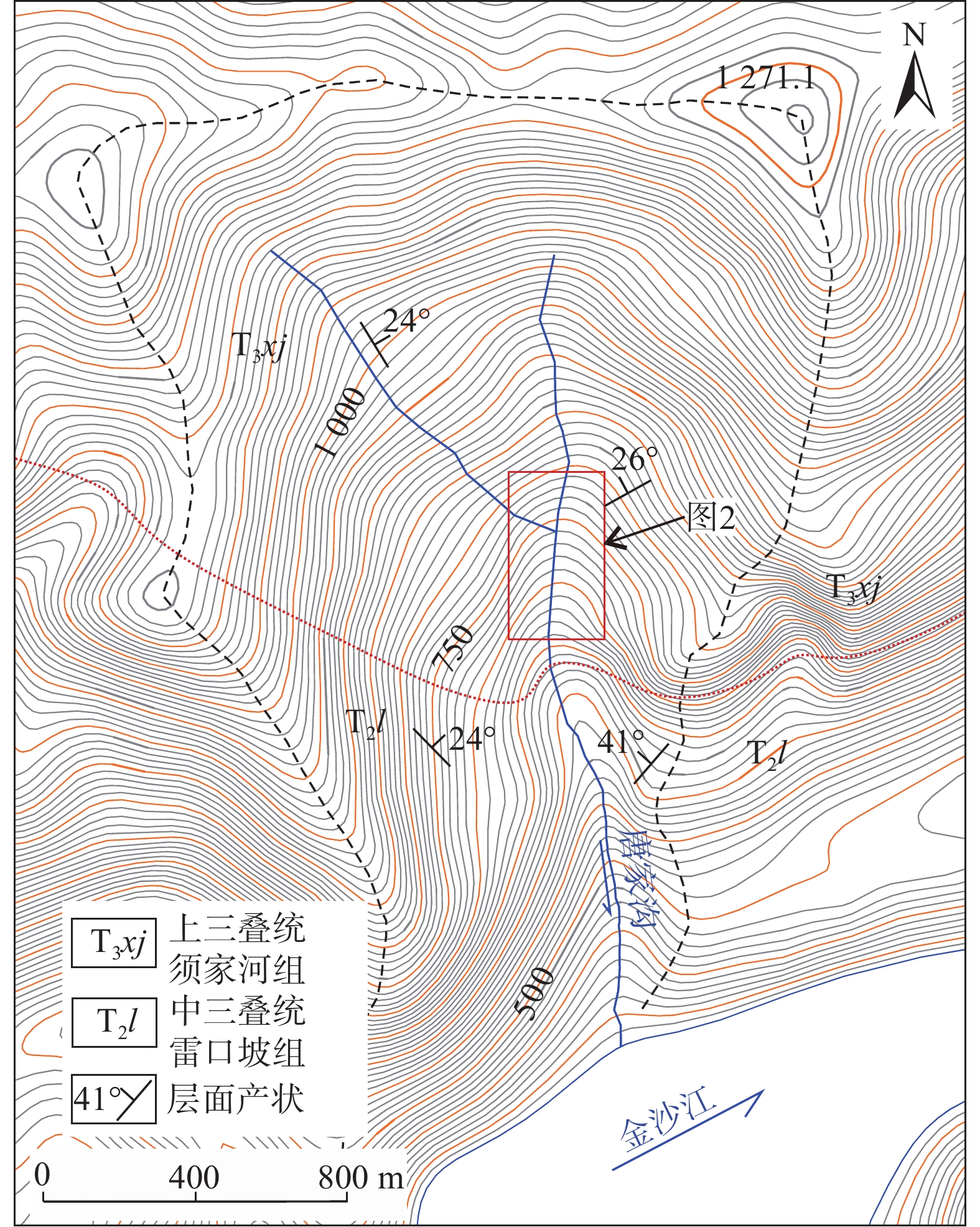
Figure 1.
Topographic and geological map of the study area
-
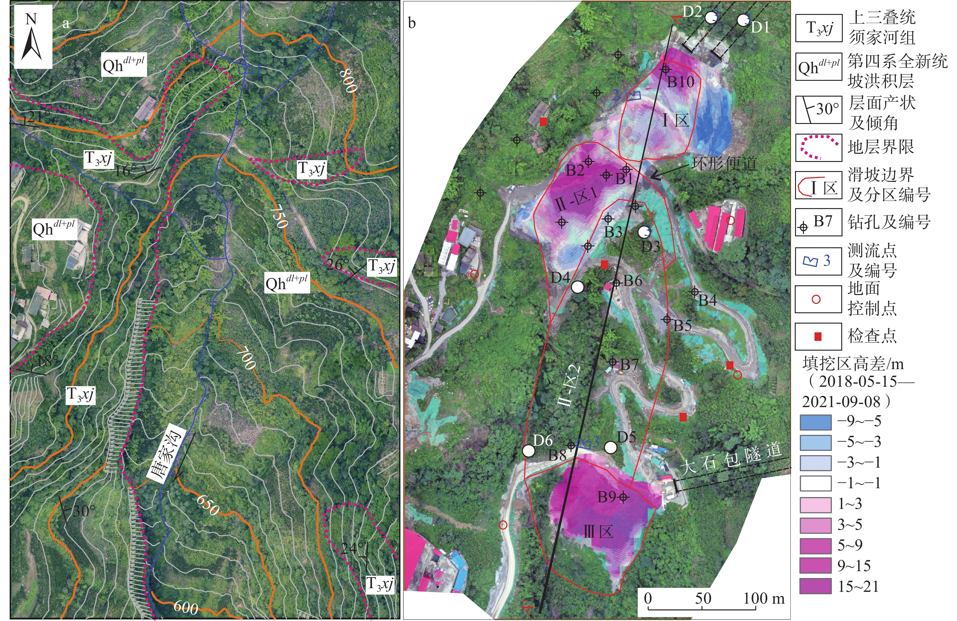
Figure 2.
Images of pre- and post-sliding and zoning map of Tangjiawan landslide
-
Figure 3.
Longitudinal profile of the landslide (section A-A’ in Fig. 2b)
-
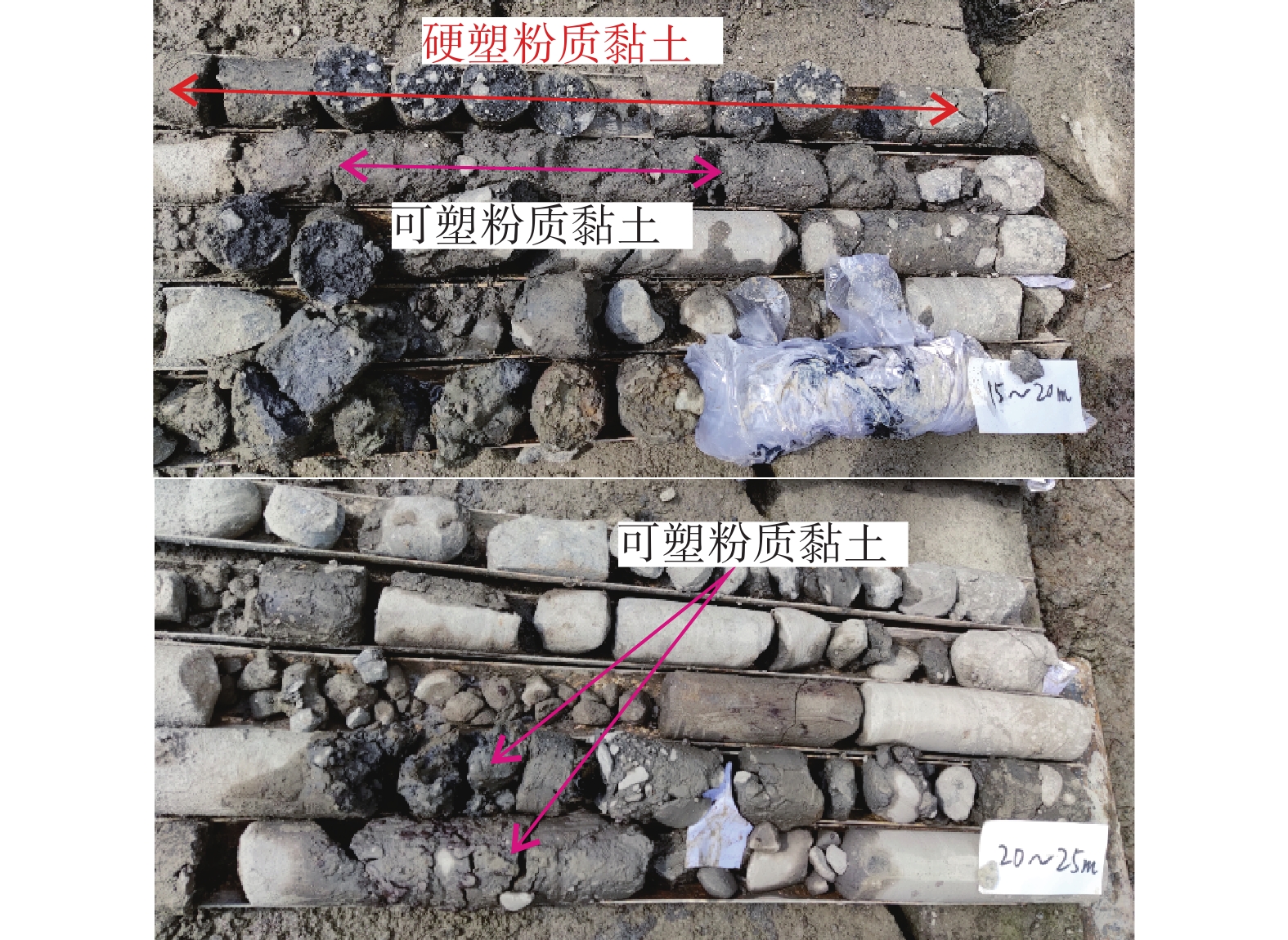
Figure 4.
Typical drilling core sample photos
-
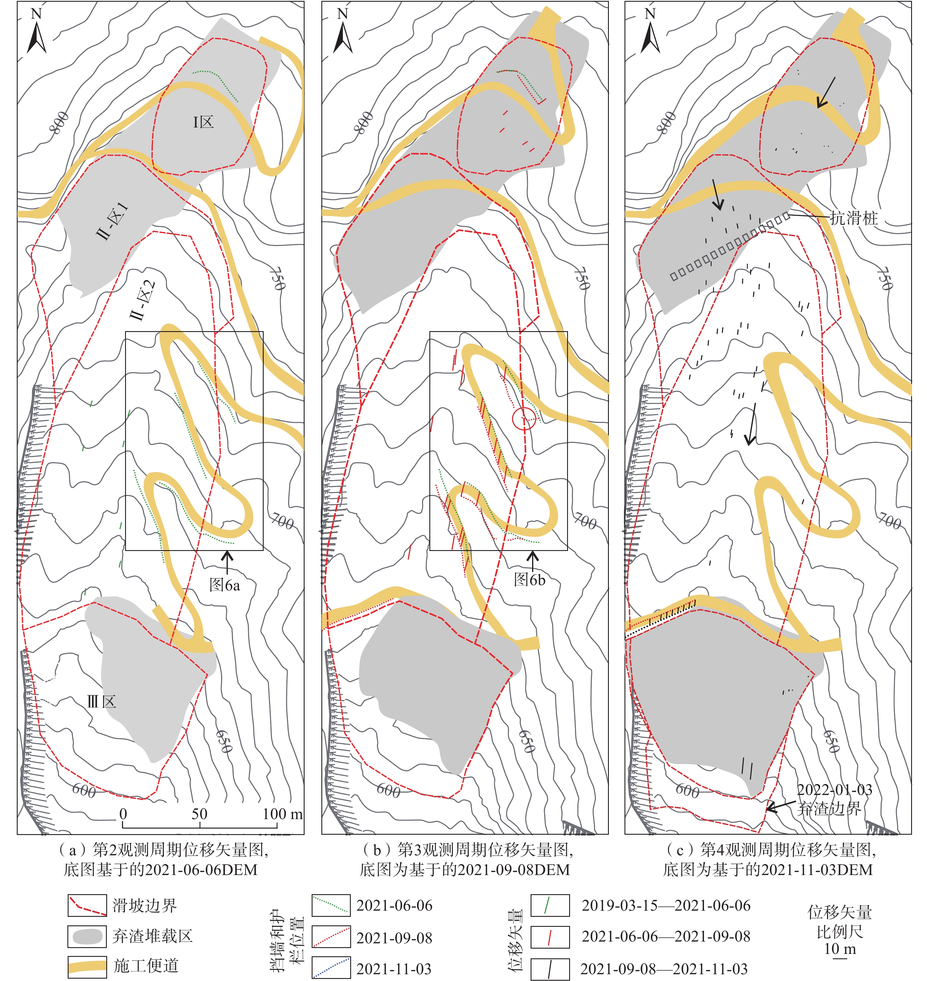
Figure 5.
Displacement vector maps for each observation period based on comparison of consecutive DOM
-
Figure 6.
Comparison images of the left boundary of the landslide
-
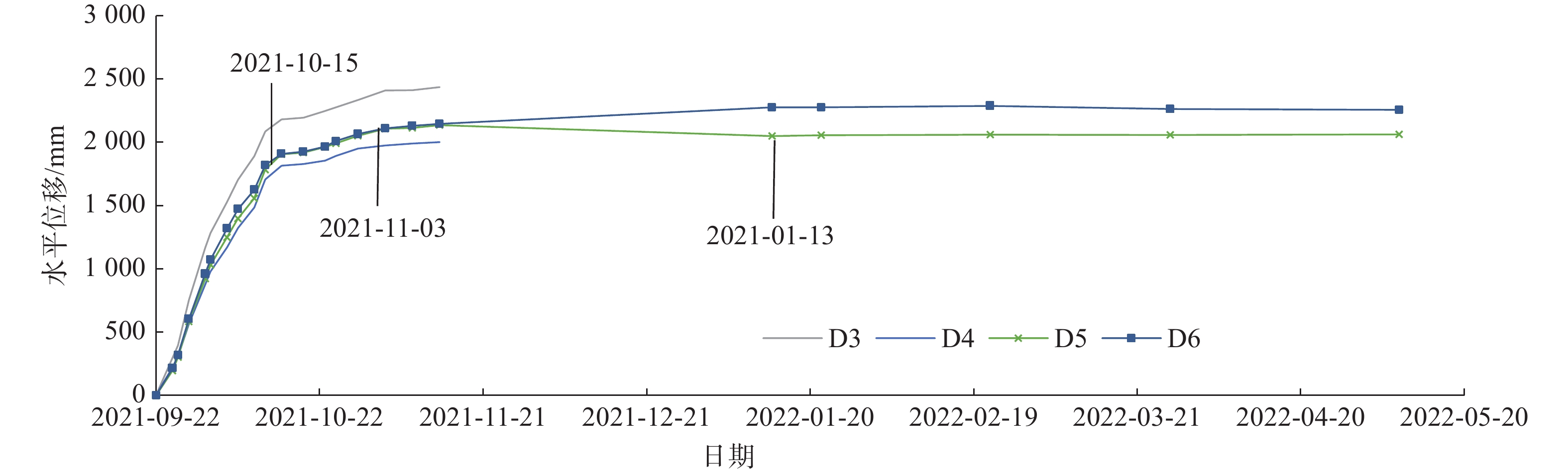
Figure 7.
Time-horizontal displacement curves for surface deformation monitoring points
-
Figure 8.
Cumulative daily precipitation and average deformation rates