
| Qingdao Institute of marine geology, China Geological Survey | Host |
| Citation: |
FU Biao, QIN Han, ZENG Weite, DING Dong, LI Huayan, SHEN Aisi, ZHU Yu. Characteristics of coastal erosion, siltation, and future development in Yazhou Bay, Sanya[J]. Marine Geology Frontiers, 2024, 40(12): 76-88. doi: 10.16028/j.1009-2722.2023.270

|
Characteristics of coastal erosion, siltation, and future development in Yazhou Bay, Sanya
-
Abstract
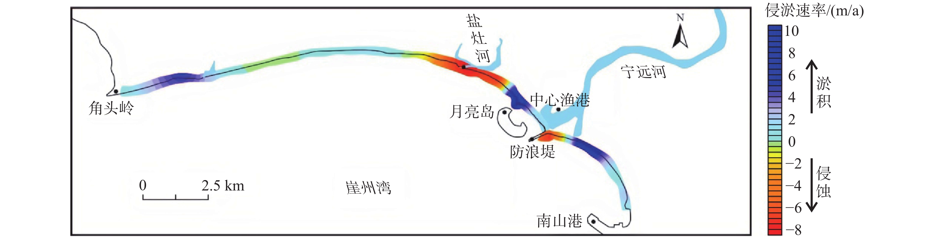
The geological survey data of the coastal zone from 2018 to 2022 in Yazhou Bay, Hainan Province, South China, were analyzed, based on which the characteristics of shoreline evolution and seabed scouring and siltation were revealed by modeling. Results indicate that in recent years, erosion along the Yazhou Bay coast was mainly concentrated in the section east of the Yanzao River estuary and east of the wave barrier of the Yazhou Bay Central Fishing Port. Siltation along the coast took place mainly in the wave shadow area of the Moon Island (artificial island) and the area of the Yazhou Bay Science and Technology City. Shoreline evolution predictions show that in future 20 years, the maximum retreat distance of the Yazhou Bay coast will be approximately 33 m in the east side of the Yanzao River estuary; and the maximum siltation distance will be approximately 99 m in the western side of the Moon Island bridge. Scouring and siltation change predictions indicate that the maximum scouring intensity of the seabed is approximately 0.14 m/a, located in the outer waters of Moon Island; the maximum siltation intensity is approximately 0.07 m/a, located in the nearshore waters of the Science and Technology City. The main reason is the construction of the Moon Island, the Central Fishing Port, and Nanshan Port, which have altered the local sediment transport direction and subsequently changed hydrodynamic conditions, thus affecting the overall scouring and siltation pattern.
-

-
References
[1] 梁超,黄磊,崔松雪,等. 近5年三亚海岸线变化研究[J]. 海洋开发与管理,2015,32(5):43-45. LIANG C,HUANG L,CUI S X,et al. Research on the changes of Sanya coastline in the past 5 years[J]. Ocean Development and Management,2015,32(5):43-45. [2] HUANG L M,TAN Y H,SONG X Y,et al. The status of the ecological environment and a proposed protection strategy in Sanya Bay,Hainan Island,China[J]. Marine Pollution Bulletin,2003,47(1/6):180-186. [3] 严珍珍,杜小平,范湘涛. 三亚湾海岸动力演变的数值模拟研究[J]. 海岸工程,2019,38(3):176-186. doi: 10.3969/j.issn.1002-3682.2019.03.002 YAN Z Z,DU X P,FAN X T. Numerical simulation of coastal dynamic evolution of the Sanya Bay[J]. Coastal Engineering,2019,38(3):176-186. doi: 10.3969/j.issn.1002-3682.2019.03.002 [4] 王艳红,曾成杰,陆培东,等. 三亚湾东段海岸侵蚀与海滩养护[J]. 自然资源学报,2022,37(4):1049-1060. doi: 10.31497/zrzyxb.20220415 WANG Y H,ZENG C J,LU P D,et al. Beach erosion and nourishment in the east section of Sanya Bay,China[J]. Journal of Natural Resources,2022,37(4):1049-1060. doi: 10.31497/zrzyxb.20220415 [5] 石海莹,陈周,吕宇波,等. 亚龙湾砂质海岸侵蚀监测和评价[J]. 海洋开发与管理,2021,38(12):80-84. SHI H Y,CHEN Z,LYU Y B,et al. Monitoring and evaluation of erosion in the sandy coast of Yalong Bay[J]. Ocean Development and Management,2021,38(12):80-84. [6] 刘会欣,张甲波,王刚,等. 海南亚龙湾海滩养护工程前后近岸波流场模拟研究[J]. 海洋湖沼通报,2020,42(4):42-53. LIU H X,ZHANG J B,WANG G,et al. Numerical simulation of nearshore qave height and flow fields before and after beach nourishment project in Yalong Bay[J]. Transactions of Oceanology and Limnology,2020,42(4):42-53. [7] 张晓浩,黄华梅,吴秋生,等. 三亚市蜈支洲岛海岸侵蚀与沉积的定量分析[J]. 热带海洋学报,2015,34(5):51-56. doi: 10.11978/2014125 ZHANG X H,HUANG H M,WU Q S,et al. Quantitative analysis of coastal erosion and deposition on Wuzhizhou Island of Sanya City[J]. Journal of Tropical Oceanography,2015,34(5):51-56. doi: 10.11978/2014125 [8] LI S Z,LV B,YANG Y P,et al. Effects of offshore artificial islands on beach stability of sandy shores:case study of Hongtang Bay,Hainan Province[J]. Frontiers of Earth Science,2022,16(4):876-889. doi: 10.1007/s11707-021-0964-7 [9] 左书华,谢华亮,崔成,等. 三亚红塘湾海域海床表层沉积物及泥沙运动特征[J]. 海洋地质前沿,2018,34(5):18-23. ZUO S H,XIE H L,CUI C,et al. Characteristics and transportion of surface sediments in Hongtang Bay of Sanya,Hainan Island[J]. Marine Geology Frontiers,2018,34(5):18-23. [10] 王世俊. 崖州湾岸线变化过程模拟研究[J]. 人民珠江,2016,37(2):26-30. WANG S J. Simulation and study on process of coastline evolution in Yazhou Bay[J]. Pearl River,2016,37(2):26-30. [11] 童朝锋,田家庆,孟艳秋,等. 崖州湾进港航道回淤特征及机制分析[J]. 中国港湾建设,2022,42(11):1-6. TONG C F,TIAN J Q,MENG Y Q,et al. Analysis on characteristics and mechanism of back-siltation in approach channel in Yazhou Bay[J]. China Harbour Engineering,2022,42(11):1-6. [12] 潘卫红,张帅,石显耀,等. 海南岛崖州湾宁远河河口区现代沉积特征[J]. 地质与勘探,2020,56(6):1278-1286. PAN W H,ZHANG S,SHI X Y,et al. Features of modern sediments in the estuarine area of the Ningyuan River Bay,Hainan Island[J]. Geology and Exploration,2020,56(6):1278-1286. [13] 瞿洪宝,苟鹏飞,孙龙飞,等. 海南岛崖州湾表层沉积物空间分布特征及其受控机制[J]. 海洋学报,2021,43(12):70-81. QU H B,GOU P F,SUN L F,et al. Spatial distribution and its controlling mechanism of surface sediments in the Yazhou Bay,Hainan Island[J]. Haiyang Xuebao,2021,43(12):70-81. [14] 盛辉,张驰,万剑华. 基于多时相遥感数据的海岸线自动提取方法[J]. 海洋科学,2021,45(5):16-22. SHENG H,ZHANG C,WAN J H. Automatic coastline extraction method based on multitemporal remote sensing data[J]. Marine Sciences,2021,45(5):16-22. [15] 苏倩欣,李高聪,李志强,等. 基于遥感数据的水边线提取方法比较:以海南岛为例[J]. 海洋技术学报,2022,41(2):20-27. SU Q X,LI G C,LI Z Q,et al. Comparing waterline extraction methods based on remote sensing data:take Hainan Island as example[J]. Journal of Ocean Technology,2022,41(2):20-27. [16] 汪尧峰. 基于无人机遥感的海岸线提取与测量方法[J]. 测绘与空间地理信息,2022,45(10):143-146. WANG Y F. Coastline extraction and measurement method based on UAV remote sensing[J]. Geomatics & Spatial Information Technology,2022,41(2):20-27. [17] 胡义强,杨骥,荆文龙,等. 基于无人机遥感的海岸带生态环境监测研究[J]. 测绘通报,2022(6):18-24. HU Y Q,YANG J,JING W L,et al. Review of coastal ecological environment monitoring based on unmanned aerial vehicle remote sensing[J]. Bulletin of Surveying and Mapping,2022(6):18-24. [18] 于得水,单瑞,梅赛,等. 基于GNSS-RTK技术的高精度海岸侵蚀监测方法[J]. 海洋地质前沿,2019,35(9):45-51. YU D S,SHAN R,MEI S,et al. High precision coastal erosion monitoring by using GNSS-RTK technology[J]. Marine Geology Frontiers,2019,35(9):45-51. [19] 胡高建,戴志军,周晓妍,等. 浙江苍南近岸海域海床冲淤过程研究[J]. 应用海洋学报,2021,40(4):688-697. HU G J,DAI Z J,ZHOU X Y,et al. Process of seabed erosion and accretion on Cangnan nearshore area,Zhejiang Province[J]. Journal of Applied Oceanography,2021,40(4):688-697. [20] 李蒙蒙,王庆,张安定,等. 最近50a来莱州湾西—南部潮流动力演变的数值模拟研究[J]. 海洋学报,2014,36(5):68-78. LI M M,WANG Q,ZHANG A D,et al. Study on the evolution of the tidal morphodynamic processes in south-western Laizhou Bay based on numerical simulation in the past 50 years[J]. Haiyang Xuebao,2014,36(5):68-78. [21] 王阳,杨红,张午. 基于MIKE21的江苏如东海上风电场泥沙冲淤数值模拟[J]. 海洋湖沼通报,2021,43(2):48-57. WANG Y,YANG H,ZHANG W. Simulation of sediment erosion and silting on Rudong offshore wind farm project in Jiangsu Province by MIKE21[J]. Transactions of Oceanology and Limnology,2021,43(2):48-57. [22] 张弛. 沙质海岸横向输运动力机制与数值模拟[M]. 南京:河海大学出版社,2010. ZHANG C. Lateral Transport Dynamics Mechanism and Numerical Simulation of Sandy Coast[M]. Nanjing:Hohai University Press,2010. [23] 王宁舸,孙林云,孙波,等. 毛里塔尼亚友谊港上下游岸线演变模拟及预测[J]. 海洋工程,2017,35(4):69-75. WANG N G,SUN L Y,SUN B,et al. Integrated simulation and forecast of upstream and downstream coastline evolution at Friendship Port in Mauritania[J]. The Ocean Engineering,2017,35(4):69-75. [24] 李松喆. 人工岛对沙质海岸动力泥沙环境及岸滩冲淤演变的影响研究[J]. 海洋工程,2021,39(4):144-153. LI S Z. Study on the influence of artificial island on dynamic sediment environment and beach erosion and deposition evolution of sandy coast[J]. The Ocean Engineering,2021,39(4):144-153. [25] Danish Hydraulic Institute(DHI). MIKE21 Flow Model:Hydrodynamic Module Scientific Documentation[M]. Denmark:DHI,2007. [26] Danish Hydraulic Institute(DHI). MIKE21 & MIKE3 Flow Model FM Hydrodynamic and Transport Modules CIENTIFICATION Documentation[M]. Denmark:Dhiwater & Environment,2007. -
Access History

Figures(17)

Export File
Citation
FU Biao, QIN Han, ZENG Weite, DING Dong, LI Huayan, SHEN Aisi, ZHU Yu. Characteristics of coastal erosion, siltation, and future development in Yazhou Bay, Sanya[J]. Marine Geology Frontiers, 2024, 40(12): 76-88. doi: 10.16028/j.1009-2722.2023.270
Format
Content
 DownLoad:


-
Figure 1.
The location and work deployment of the study area
-
Figure 2.
Schematic diagram of the mathematical model grid for tidal currents and waves
-
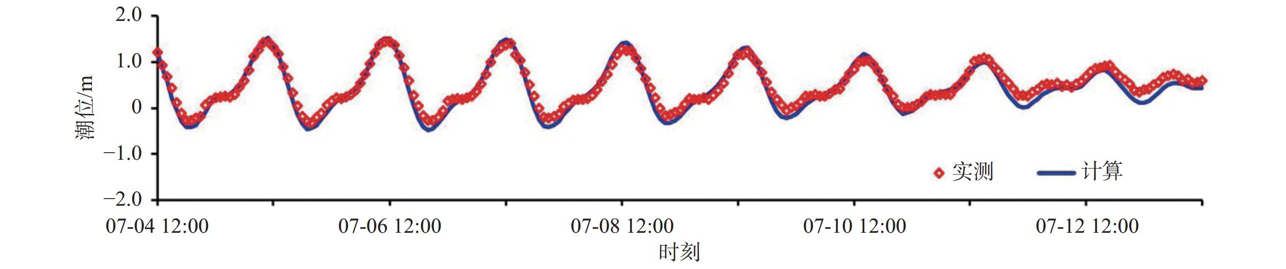
Figure 3.
Comparison of tidal level curves
-
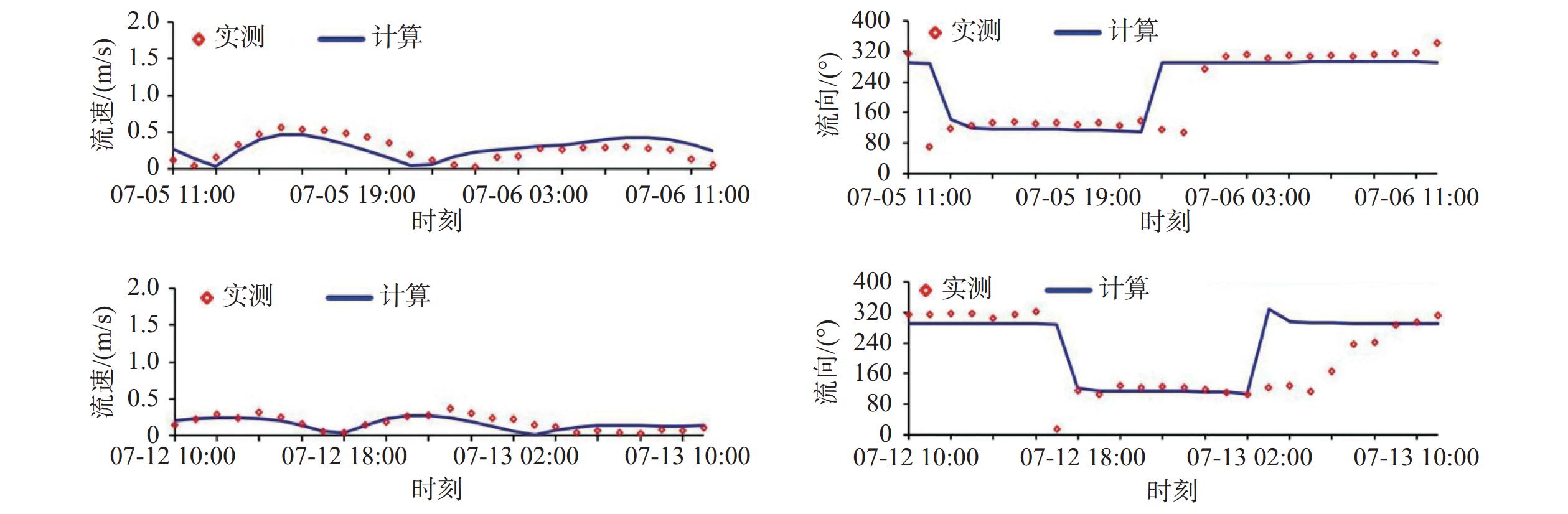
Figure 4.
Comparison in flow velocity and direction of spring tide (upper) and neap tide (lower)
-
Figure 5.
Comparison of Yazhou Bay coastline during 1990-2020
-
Figure 6.
Erosion and siltation distance of beach profile from 2020 to 2022
-
Figure 7.
Erosion and siltation rate of beach profile from 2020 to 2022
-
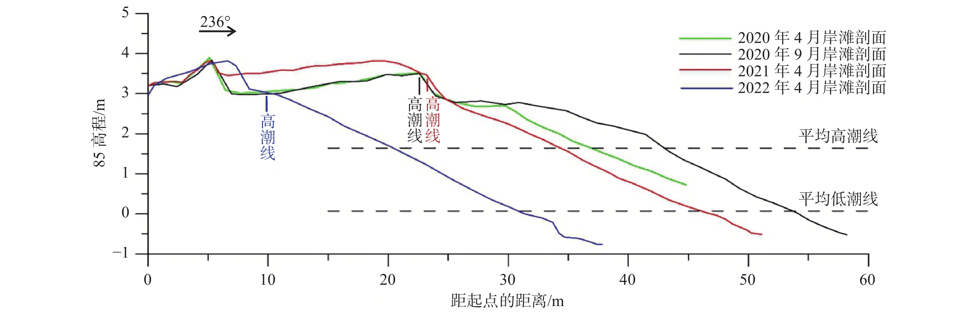
Figure 8.
SY04 beach profile
-
Figure 9.
ATSY11 beach profile
-
Figure 10.
SY05 beach profile
-
Figure 11.
Calculation results of coastline evolution in the section west of Yazhou Central Fishing Port
-
Figure 12.
Calculation results of shoreline evolution in the section east of Yazhou Central Fishing Port
-
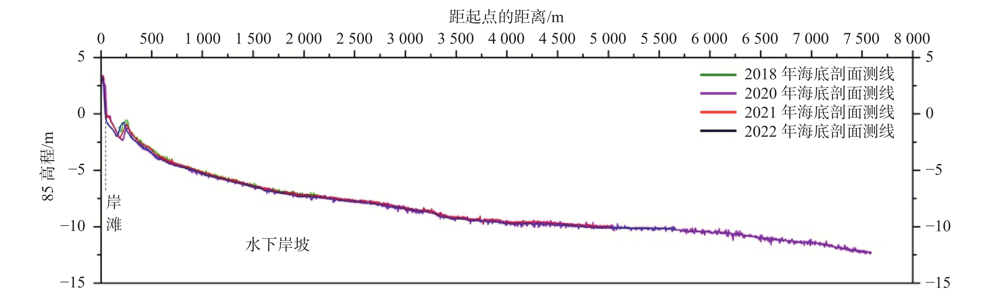
Figure 13.
The SY04 seafloor topography profile
-
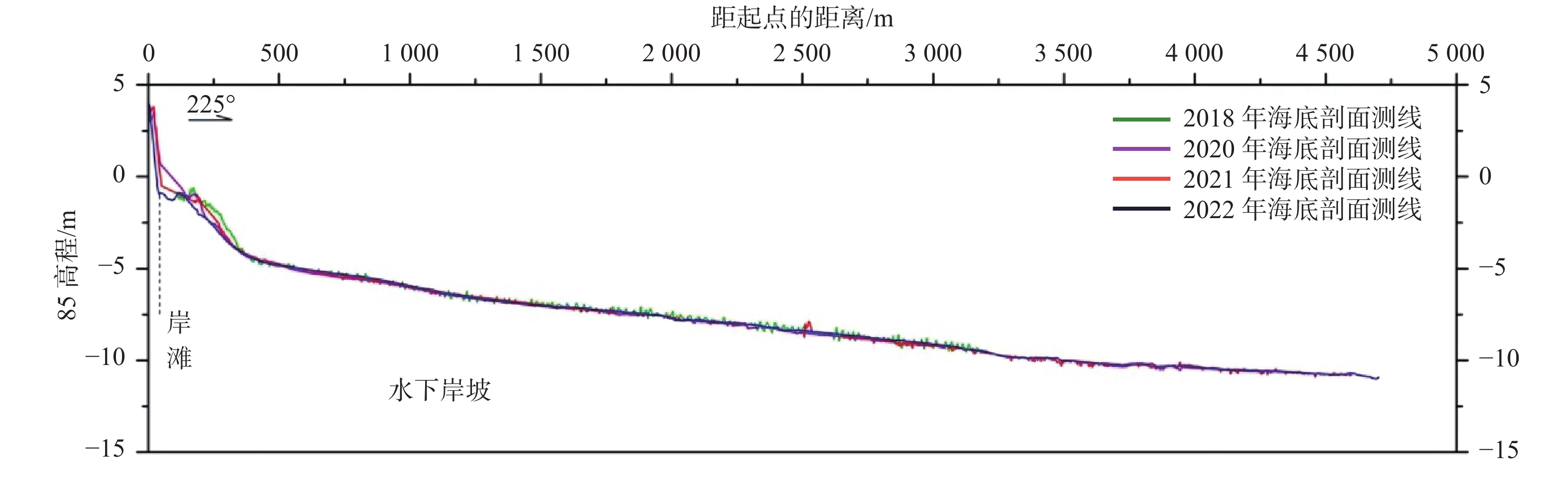
Figure 14.
The SY05 seafloor topography profile
-
Figure 15.
Tidal current fields of spring tide in Yazhou Bay
-
Figure 16.
Representative wave field in the Yazhou Bay
-
Figure 17.
Annual average distribution of scouring and siltation on the seabed of Yazhou Bay