
| Qingdao Institute of marine geology, China Geological Survey | Host |
| Citation: |
SONG Huairong, SU Guohui, SUN Jihong, WEI Helong, LIN Wenrong. LANDSCAPE CHANGES OF THE YANCHENG WETLAND IN THE PAST 20 YEARS: EVIDENCE FROM RANDOM FOREST[J]. Marine Geology Frontiers, 2021, 37(12): 75-82. doi: 10.16028/j.1009-2722.2021.073

|
LANDSCAPE CHANGES OF THE YANCHENG WETLAND IN THE PAST 20 YEARS: EVIDENCE FROM RANDOM FOREST
-
Abstract
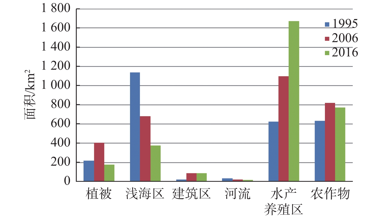
To study wetland landscape and its dynamic changes can effectively monitor the changes in wetland ecosystem. In this paper, we selected the core wetland of the Yancheng National Rare Birds Nature Reserve in Jiangsu Province as a research focus, and used the methods of maximum likelihood, CART decision tree and random forest to extract information from the core area of the wetland. Our results suggest that the method of random forest has the highest accuracy. The overall classification accuracy is 91.02% with a Kappa coefficient up to 0.89. The method of random forest is adopted as the mean to extract landscape information from the entire coastal wetland of Yancheng and obtained are the six landscape categories of wetland in 1995, 2006, and 2016 respectively. The annual changes of the six types of landscapes are analyzed by transfer matrix. The results show that the area of Yancheng wetland is increasing in an overall trend and the aquaculture areas is continuously expanding to shallow waters. Although the vegetation, construction areas and crop areas were all increased during the period of 1995—2006, they had basically remained stable during the latter period of 2006—2016, especially the areas of nature reserves were kept unchanged.
-
Keywords:
- random forest /
- decision tree /
- landscape classification /
- coastal wetland
-

-
References
[1] LV X G, WANG R F. Study on wetland biodiversity in china[J]. Chinese Geographical Science, 1996, 6(1): 15-23. [2] 刘润红,梁士楚,赵红艳,等. 中国滨海湿地遥感研究进展[J]. 遥感技术与应用,2017,32(6):998-1011. [3] 王聪,刘红玉,候明行,等. 淤泥质潮滩湿地类型遥感识别分类方法与应用[J]. 地球信息科学学报,2013,15(4):590-596. [4] 蒋佳文,温小荣,王海龙,等. 10年间盐城滨海湿地类型信息提取及动态变化分析[J]. 西北林学院学报,2019,34(3):167-173,184. doi: 10.3969/j.issn.1001-7461.2019.03.26 [5] 张东方,杜嘉,陈智文,等. 20世纪60年代以来6个时期盐城滨海湿地变化及其驱动因素研究[J]. 湿地科学,2018,16(3):313-321. [6] 刘力维,张银龙,汪辉,等. 1983—2013年江苏盐城滨海湿地景观格局变化特征[J]. 海洋环境科学,2015,34(1):93-100. [7] 卢霞,赵倩,林雅丽,等. 大丰麋鹿自然保护区土地利用/覆盖变化监测研究[J]. 淮海工学院学报(自然科学版),2018,27(3):74-81. [8] 刘翔,刘会玉,林振山,等. 基于Landsat OLI影像的盐城滨海湿地分类方法对比研究[J]. 湿地科学,2017,15(5):689-696. [9] 张健,何祺胜,崔同,等. 基于遥感和GIS的江苏滨海地区湿地信息提取及动态变化分析[J]. 长江科学院院报,2017,34(4):144-150. [10] 金宇,高吉喜,周可新, 等. 围垦及米草入侵下江苏中部滨海湿地土地利用/覆被类型动态变化[J]. 地理研究,2017,36(8):1478-1488. [11] 任武阳,王成,刘红玉,等. 基于鸟类生境需求的植被景观覆盖度多样性:以江苏盐城滨海湿地为例[J]. 生态学杂志,2019,38(12):3870-3877. [12] 唐江浪,李涛,李刚,等. 厦门及其邻域近40年海岸线变迁[J]. 海洋地质前沿,2020,36(5):14-21. [13] 黄静,赵庚星. 基于遥感和 GIS 的黄河口最近20年淤蚀时空动态及水沙影响[J]. 海洋地质前沿,2021,37(3):16-21. [14] 肖锦成,欧维新,符海月. 基于BP神经网络与ETM+遥感数据的盐城滨海自然湿地覆被分类[J]. 生态学报,2013,33(23):7496-7504. [15] 王华,王建华,潘玉雯,等. 东台市滨海湿地围垦影响的定量评估[J]. 江苏林业科技,2018,45(5):39-43. doi: 10.3969/j.issn.1001-7380.2018.05.009 [16] 张濛,濮励杰. 近30年来江苏省滨海湿地变化过程及其受围垦活动的影响[J]. 湿地科学与管理,2017,13(3):56-60. doi: 10.3969/j.issn.1673-3290.2017.03.11 [17] 廖华军,李国胜,王少华,等. 近30年苏北滨海滩涂湿地演变特征与空间格局[J]. 地理科学进展,2014,33(9):1209-1217. [18] 杜培军,陈宇,谭琨. 江苏滨海湿地土地利用/覆盖变化与地表温度响应遥感监测[J]. 国土资源遥感,2014,26(2):112-120. [19] 左平,李云,赵书河,等. 1976年以来江苏盐城滨海湿地景观变化及驱动力分析[J]. 海洋学报(中文版),2012,34(1):101-108. [20] LINDEN S V D, RABE A, HELD M, et al. The EnMAP-Box: a toolbox and application programming interface for EnMAP data processing. Remote Sense, 2015, 7(9), 11249-11266. -
Access History
Figures(6)
Tables(5)

Export File
Citation
SONG Huairong, SU Guohui, SUN Jihong, WEI Helong, LIN Wenrong. LANDSCAPE CHANGES OF THE YANCHENG WETLAND IN THE PAST 20 YEARS: EVIDENCE FROM RANDOM FOREST[J]. Marine Geology Frontiers, 2021, 37(12): 75-82. doi: 10.16028/j.1009-2722.2021.073
Format
Content
 DownLoad:
-
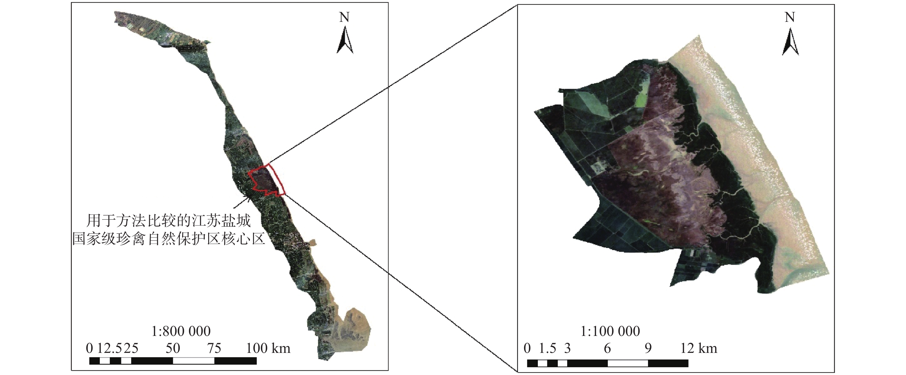
Figure 1.
Study area of the article
-
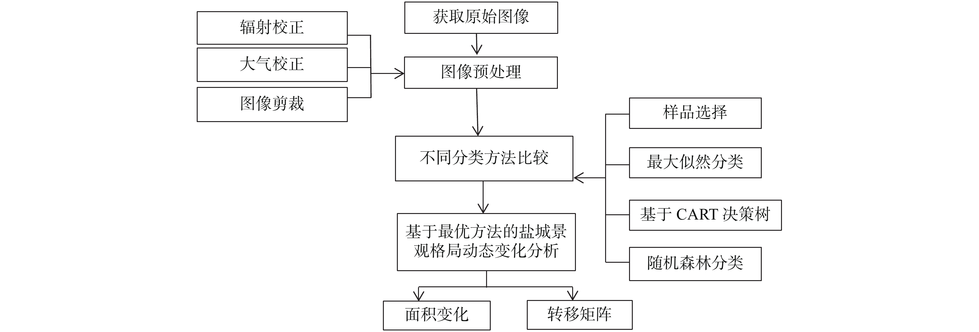
Figure 2.
Technical flowchart
-
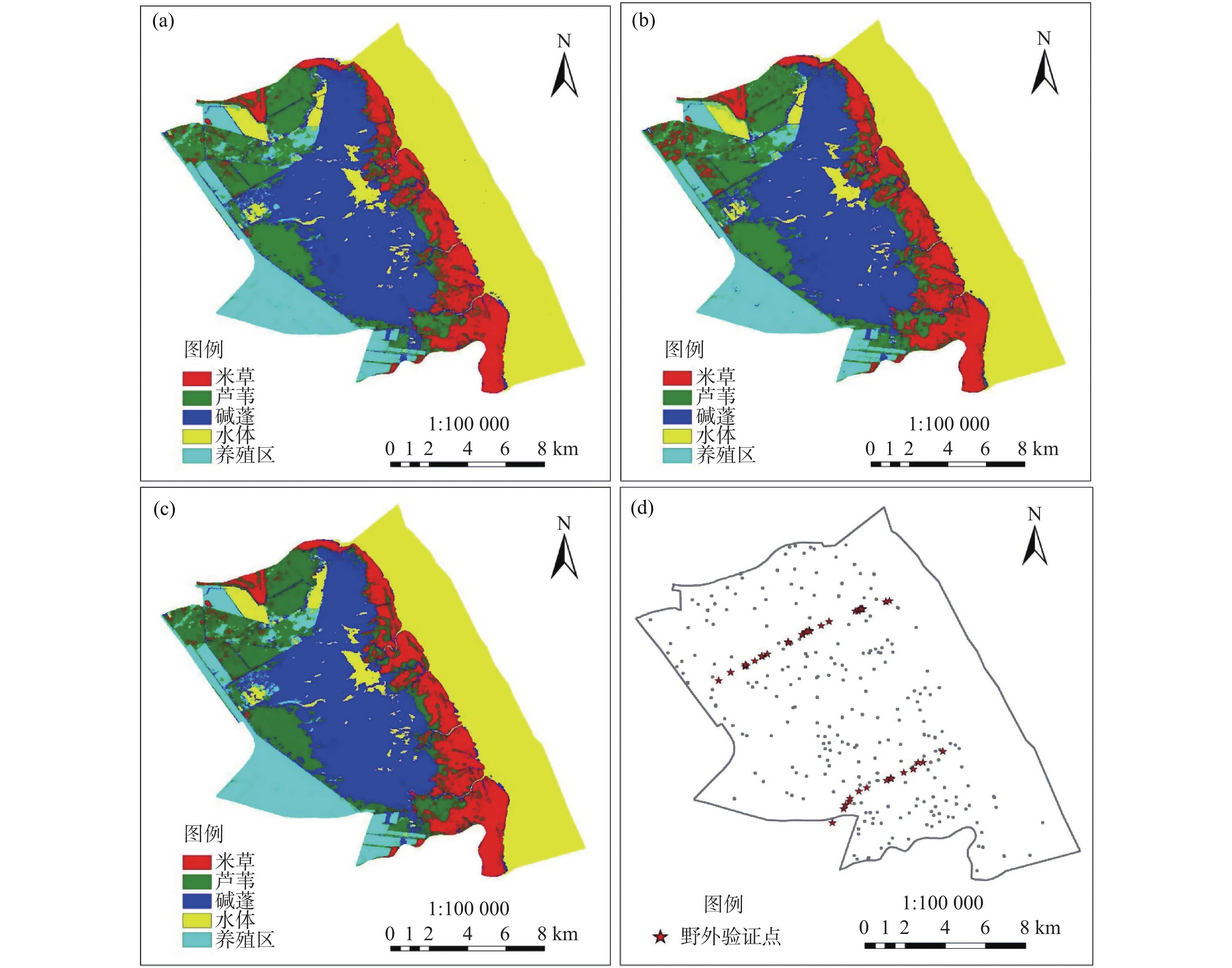
Figure 3.
Interpretation results and verification points for the three classification methods of images in 2006
-
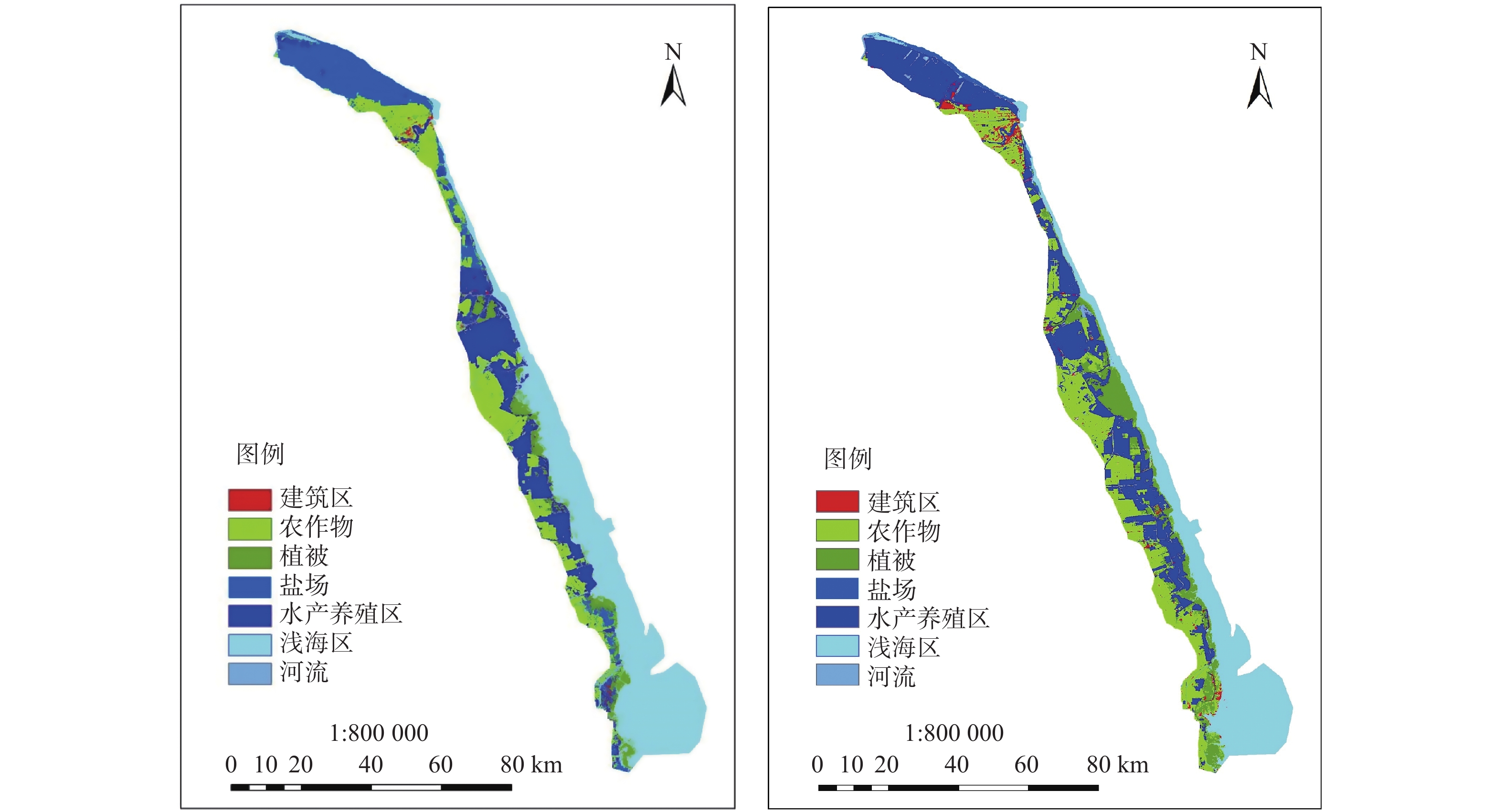
Figure 4.
Landscape distribution map of coastal wetlands in Yancheng, Jiangsu Province in 1995 and 2006
-
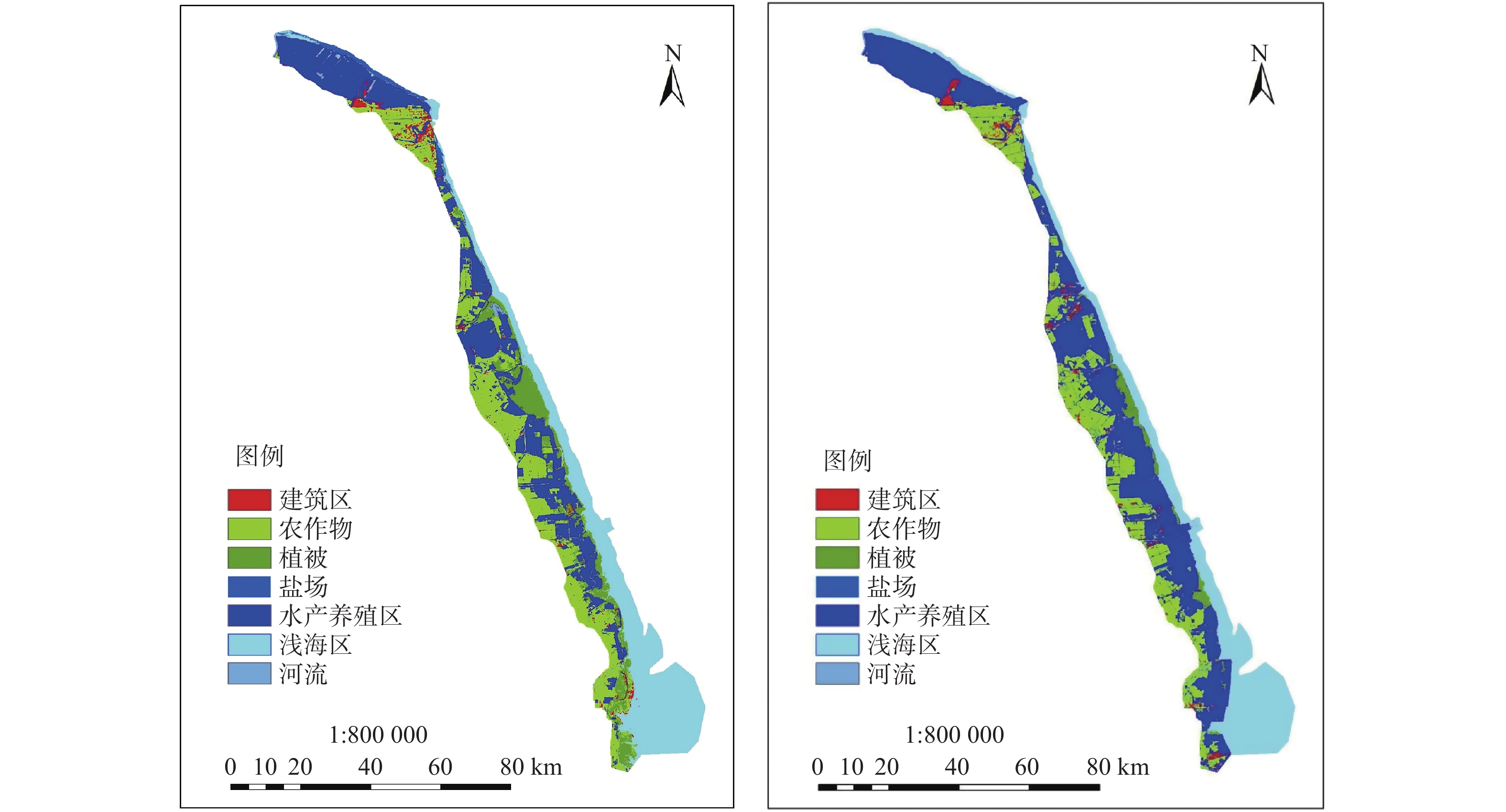
Figure 5.
Landscape distribution map of coastal wetlands in Yancheng, Jiangsu Province in 2006 and 2016
-
Figure 6.
Changes in landscape area of coastal wetlands in Yancheng, Jiangsu Province in 1995, 2006 and 2016