

| Citation: |
LIU Xiaoyu, LI Shijie, HE Haiyang, QIN Haoyang, WANG Siqi, SUN Xu. 2024. Analysis of Land Use Change and Habitat Quality Evolution Based on InVEST and PLUS Models: Example from Hanzhong Basin. Northwestern Geology, 57(4): 271-284. doi: 10.12401/j.nwg.2024048

|
Analysis of Land Use Change and Habitat Quality Evolution Based on InVEST and PLUS Models: Example from Hanzhong Basin
-
Abstract
Hanzhong Basin is an important source area in China's South-to-North Water Diversion Project. Analyzing land use and habitat quality within the region can enhance our understanding of its evolutionary patterns and further protect the natural resources and ecological environment security of the downstream working areas. This paper establishes a multi-type land use database and a habitat quality assessment system for the working area based on three periods of land use data from 2000 to 2020. It studies the spatiotemporal changes of land use in the research area from multiple aspects including land use transition matrix, landscape pattern indices, and habitat quality, and uses the PLUS model for land use expansion and prediction analysis. The results show that from 2000 to 2020, there were significant changes in land use types, mainly transfers between paddy fields, rural residential land, and urban land. The sprawl index decreased year by year, indicating a high degree of landscape fragmentation. Habitat quality results showed a downward trend year by year, with the area of high values decreasing and expanding southward, and the area of low values increasing, radiating outward from urban centers. High-grade ecological quality landscapes, dominated by water bodies and forests and grasslands, are mainly distributed along the Han river basin.
-
Keywords:
- InVEST model /
- PLUS model /
- land use /
- transfer matrix /
- landscape pattern /
- simulated prediction
-

-
References
[1] 陈颐, 林毅伟, 林丽丽, 等. 基于Markov和LoGIStic模型的莆田市土地利用变化及林地转出空间模拟[J]. 中国农业大学学报, 2017, 22(2): 87−97. doi: 10.11841/j.issn.1007-4333.2017.02.011 CHEN Yi, LIN Yiwei, LIN Lili, et al. Spatial simulation of land use change and forest land transfer in Putian City based on Markov and LoGIS models[J]. Journal of China Agricultural University,2017,22(2):87−97. doi: 10.11841/j.issn.1007-4333.2017.02.011 [2] 曹雪, 罗平, 李满春, 等. 基于扩展CA模型的土地利用变化时空模 拟研究——以深圳市为例[J]. 资源科学, 2011, 33(1): 127−133. CAO Xue, LUO Ping, LI Manchun, et al. Study on spatiotemporal simulation of land use change based on extended CA model: A case study of Shenzhen City[J]. Resource Science,2011,33(1):127−133. [3] 陈竹安, 刘子强, 张立亭, 等. 南昌市LUCC多情景模拟 和生境质量时空演变与预测[J]. 农业机械学报, 2023, 54(5): 170−180. CHEN Zhu’an, LIU Ziqiang, ZHANG Liting, et al. Multi scenario simulation and spatiotemporal evolution and prediction of habitat quality in Nanchang LUCC[J]. Journal of Agricultural Machinery,2023,54(5):170−180. [4] 代克志. 基于3S技术的花溪河流域景观格局变化及影响研究[D]. 贵州: 贵州师范大学, 2015. DAI Kezhi. Research on Landscape Pattern Changes and Impact in the Huaxi River Basin Based on 3S Technology [D]. Guizhou: Guizhou Normal University, 2015. [5] 冯雨林, 杨佳佳, 吴梦红. 基于景观转移矩阵的黑龙江双河自然护区土地覆被转移研究[J]. 地质与资源, 2016, 25(5): 1−5. FENG Yulin, YANG Jiajia, WU Menghong. Research on land cover transfer in the Shuanghe Nature Reserve of Heilongjiang Province based on landscape transfer matrix[J]. Geology and Resources,2016,25(5):1−5. [6] 范树平, 程从坤, 刘友兆, 等. 中国土地利用/土地覆盖研究综述与展望[J]. 地域研究与开发, 2017, 36(2): 94−101. doi: 10.3969/j.issn.1003-2363.2017.02.018 FAN Shuping, CHENG Congkun, LIU Youzhao, et al. A Review and Prospects of Land Use/Land Cover Research in China[J]. Regional Research and Development,2017,36(2):94−101. doi: 10.3969/j.issn.1003-2363.2017.02.018 [7] 高文龙, 张景华, 刘洪, 等. 基于转移矩阵的大凉山区土地利用变化研究[J/OL]. 西北地质, 2023: 1−13. doi: 10.12401/j.nwg.2023167. GAO Wenlong,ZHANG Jinghua,LIU Hong,et al. Research on Land Use Change in Daliangshan District Based on Transfer Matrix [J/OL]. Northwest Geology,2023: 1−13. Doi: 10.12401/j.nwg.2023167. [8] 黄钰清, 李骁尧. 1995-2020年黄河流域土地利用变化及驱动力分析[J]. 西北林学院学报, 2020, 37(6): 113−121. HUANG Yuqing, LI Xiaoyao. Analysis of Land Use Changes and Driving Forces in the Yellow River Basin from 1995 to 2020[J]. Journal of Northwest Forestry University,2020,37(6):113−121. [9] 韩朝辉, 王郅睿, 田辉, 等. 汉中盆地地下水水化学特征及其成因研究[J]. 西北地质, 2023, 56(4): 263−273. HAN Chaohui, WANG Zhirui, TIAN Hui, et al. Hydrochemical Characteristics and Genesis of Groundwater in the Hanzhong Basin[J]. Northwestern Geology,2023,56(4):263−273. [10] 黄金亭, 曹艳萍, 秦奋. 基于土地利用/覆盖变化模拟的黄河流域生态环境质量分析[J]. 河南大学学报: 自然科学版, 2020, 50(2): 127−138. HUANG Jinting, CAO Yanping, QIN Fen. Analysis of Ecological Environment Quality in the Yellow River Basin Based on Land Use/Cover Change Simulation[J]. Journal of Henan University: Natural Science Edition,2020,50(2):127−138. [11] 胡丰, 张艳, 郭宇, 等. 基于PLUS和InVEST模型的渭河流域土地利用与生境质量时空变化及预测[J]. 干旱区地理, 2011, 45(4): 1125−1136. HU Feng, ZHAGN Yan, GUO Yu, et al. Spatial and temporal changes and prediction of land use and habitat quality in the Wei River Basin based on PLUS and InVEST models[J]. Arid Region Geography,2011,45(4):1125−1136. [12] 吕桂军. 长时间序列LandsatTM影像应用于地理国情监测中的 技术方法探讨[D]. 焦作: 河南理工大学, 2014. LV Guijun. Exploration of Technical Methods for Applying Long Time Series LandsatTM Images to Geographical and National Monitoring [D]. Jiaozuo: Henan University of Technology, 2014. [13] 梁甜, 黄茜, 杨霏. 基于InVEST-PLUS模型的三峡库区(重庆段)生境质量演变及预测[J]. 长江流域资源与环境, 2023, 32(10): 2184−2195. LIANG Tian, HUANG Qian, YANG Fei. Habitat quality evolution and prediction in the Three Gorges Reservoir Area (Chongqing section) based on the InVEST-PLUS model[J]. Yangtze River Basin Resources and Environment,2023,32(10):2184−2195. [14] 刘纪远, 宁佳, 匡文慧, 等. 2010-2015年中国土地利用变化的时空格局与新特征[J]. 地理学报, 2020, 73(5): 789−802. LIU Jiyuan, NING Jia, KUANG Wenhui, et al. The spatiotemporal pattern and new characteristics of land use change in China from 2010 to 2015[J]. Journal of Geography,2020,73(5):789−802. [15] 李灿, 曾和平. 基于面积转移矩阵的龙川江流域土地利用变化研究[J]. 人民长江, 2018, 49(17): 06−13. LI Can, ZENG Heping. Research on Land Use Change in the Longchuan River Basin Based on Area Transfer Matrix[J]. Yangtze River,2018,49(17):06−13. [16] 陶蕴之, 张甜, 梁琦珍, 等. 基于转移矩阵的环渤海土地利用研究[J]. 绿色科技, 2016, 37(2): 4−7. doi: 10.3969/j.issn.1674-9944.2016.02.002 TAO Yunzhi, ZHANG Tian, LIANG Qizhen, et al. Research on Land Use of Bohai Rim Based on Transfer Matrix[J]. Green Science and Technology,2016,37(2):4−7. doi: 10.3969/j.issn.1674-9944.2016.02.002 [17] 卫建军, 李新平, 杨勤科. 基于遥感的土地利用与退耕还林时空变化研究—以延河流域下游地区为例[J]. 水土保持通报, 2007(2): 87−90. doi: 10.3969/j.issn.1000-288X.2007.02.020 WEI Jianjun, LI Xinping, YANG Qinke. Research on spatiotemporal changes of land use and returning farmland to forests based on remote sensing: A case study of the lower reaches of the Yanhe River Basin[J]. Soil and Water Conservation Bulletin,2007(2):87−90. doi: 10.3969/j.issn.1000-288X.2007.02.020 [18] 王颖维, 张亚峰, 钱信禹, 等. 南水北调中线工程丹江源地区生态地质格局动态演变[J]. 西北地质, 2023, 56(3): 129−140. WANG Yingwei, ZHANG Yafeng, QIAN Xinyu, et al. Dynamic Evolution of Eco−geological Pattern: Taking Danjiangyuan Area of Central Line Project of South−to−North Water Diversion[J]. Northwestern Geology,2023,56(3):129−140. [19] 杨朔, 苏昊, 赵国平. 基于PLUS模型的城市生态系统服务价值多情景模拟: 以汉中市为例[J]. 干旱区资源与环境, 2022, 36(10): 86−95. YANG Shuo, SU Hao, ZHAO Guoping. Multi scenario simulation of urban ecosystem service value based on PLUS model: A case study of Hanzhong City[J]. Resources and Environment in Arid Areas,2022,36(10):86−95. [20] 阳柏苏. 景区土地利用格局及生态系统服务功能研究[D]. 长沙: 中南林业科技大学, 2005. YANG Baisu. Research on Land Use Patterns and Ecosystem Services in Scenic Spots [D]. Changsha: Central South University of Forestry and Technology, 2005. [21] 岳东霞, 杜军, 刘俊艳, 等. 基于RS和转移矩阵的泾河流域生态承载力时空动态评[J]. 生态学报, 2011, 31(9): 2550−2558. YUE Dongxia, DU Jun, LIU Junyan, et al. Spatial and temporal dynamic evaluation of ecological carrying capacity in the Jinghe River Basin based on RS and transfer matrix[J]. Journal of Ecology,2011,31(9):2550−2558. [22] 张冉, 王义民, 畅建霞, 等. 基于水资源分区的黄河流域土地利用变化对人类活动的响应[J]. 自然资源学报, 2019, 34(2): 274−287. doi: 10.31497/zrzyxb.20190205 ZHANG Ran, WANG Yimin, CHANG Jianxia, et al. Response of land use change in the Yellow River Basin to human activities based on water resource zoning[J]. Journal of Natural Resources,2019,34(2):274−287. doi: 10.31497/zrzyxb.20190205 [23] 张立新, 段文凯. 经济转型背景下城市土地城镇化格局 及影响因素—以长江经济带城市为例[J]. 国农业大学学报, 2021, 26(9): 206−215. ZHANG Lixin, DUAN Wenkai. Urban Land Urbanization Pattern and Influencing Factors under the Background of Economic Transformation: A Case Study of Cities in the Yangtze River Economic Belt[J]. Journal of China Agricultural University,2021,26(9):206−215. [24] 张恒义, 刘卫东, 王世忠, 等. “省公顷”生态足迹模型中均衡因子及产量因子的计算: 以浙江省为例[J]. 自然资源学报, 2009, 24(1): 82−92. doi: 10.3321/j.issn:1000-3037.2009.01.010 ZHANG Hengyi, LIU Weidong, WANG Shizhong, et al. Calculation of Equilibrium Factors and Yield Factors in the Ecological Footprint Model of "Provincial Hectares": Taking Zhejiang Province as an Example[J]. Journal of Natural Resources,2009,24(1):82−92. doi: 10.3321/j.issn:1000-3037.2009.01.010 [25] Faichia C, Tong Z, Zhang J, et al. Using RS Data-Based CA–Markov Model for Dynamic Simulation of Historical and Future LUCC in Vientiane, Laos[J]. Sustainability,2020,12(20):8410−8419. doi: 10.3390/su12208410 [26] Lambin EF, Turbner B, Geist HJ, et al. The cauyses of land-use and land-over change: moviong beyong the myths[J]. Global enviroment change,2001,11(4):261−269. doi: 10.1016/S0959-3780(01)00007-3 [27] Newbold T, Hudson L N, Phillips HR, et al. A global model of the response of tropical and sub-tropical forest biodiversity to anthropo genic pressures[J]. Proceedings Biological Sciences,2014,281(1792):1−10. [28] Verburg P H, De konnig G, Kok K, et al. A spatial explicit allocation procedure for modeling the pattern of land use change based upon actual land use[J]. Ecoligical modelling,1999,116(1):45−61. doi: 10.1016/S0304-3800(98)00156-2 -
Access History

Figures(8)
Tables(5)

Export File
Citation
LIU Xiaoyu, LI Shijie, HE Haiyang, QIN Haoyang, WANG Siqi, SUN Xu. 2024. Analysis of Land Use Change and Habitat Quality Evolution Based on InVEST and PLUS Models: Example from Hanzhong Basin. Northwestern Geology, 57(4): 271-284. doi: 10.12401/j.nwg.2024048
Format
Content
 DownLoad:


-
Figure 1.
Geographic location map of Hanzhong basin
-
Figure 2.
Distribution of land use types in Hanzhong basin in 2020-2022
-
Figure 3.
Chord diagram of land stochastic matrix
-
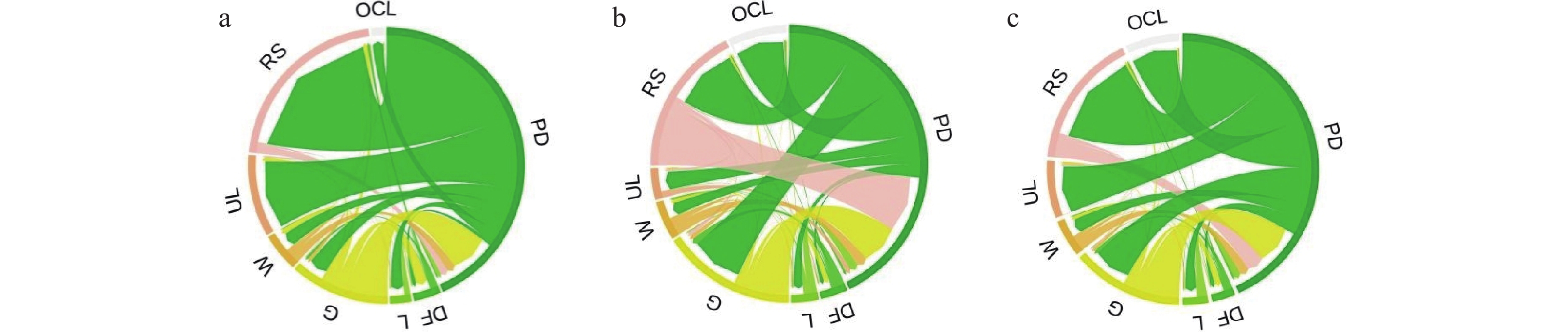
Figure 4.
Chord diagram of land stochastic matrix
-
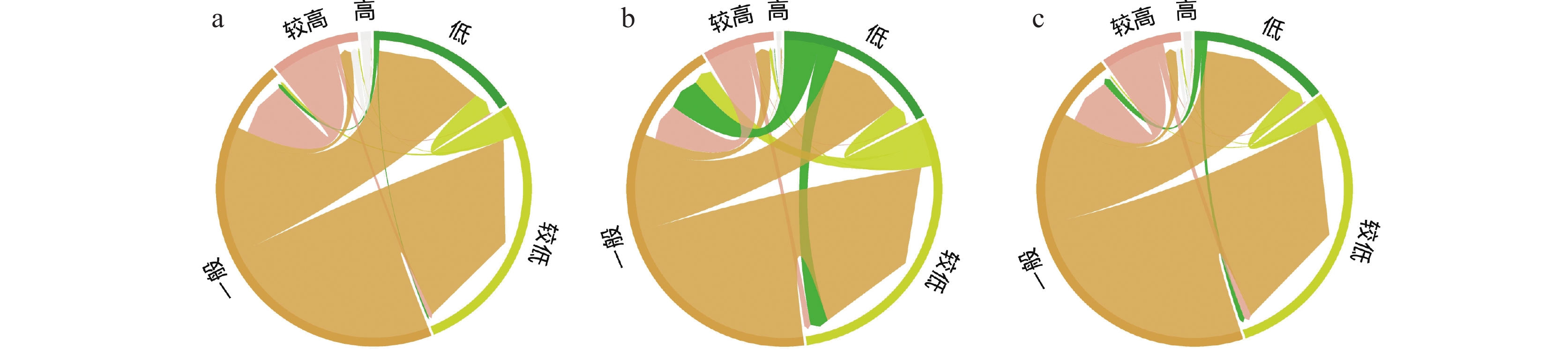
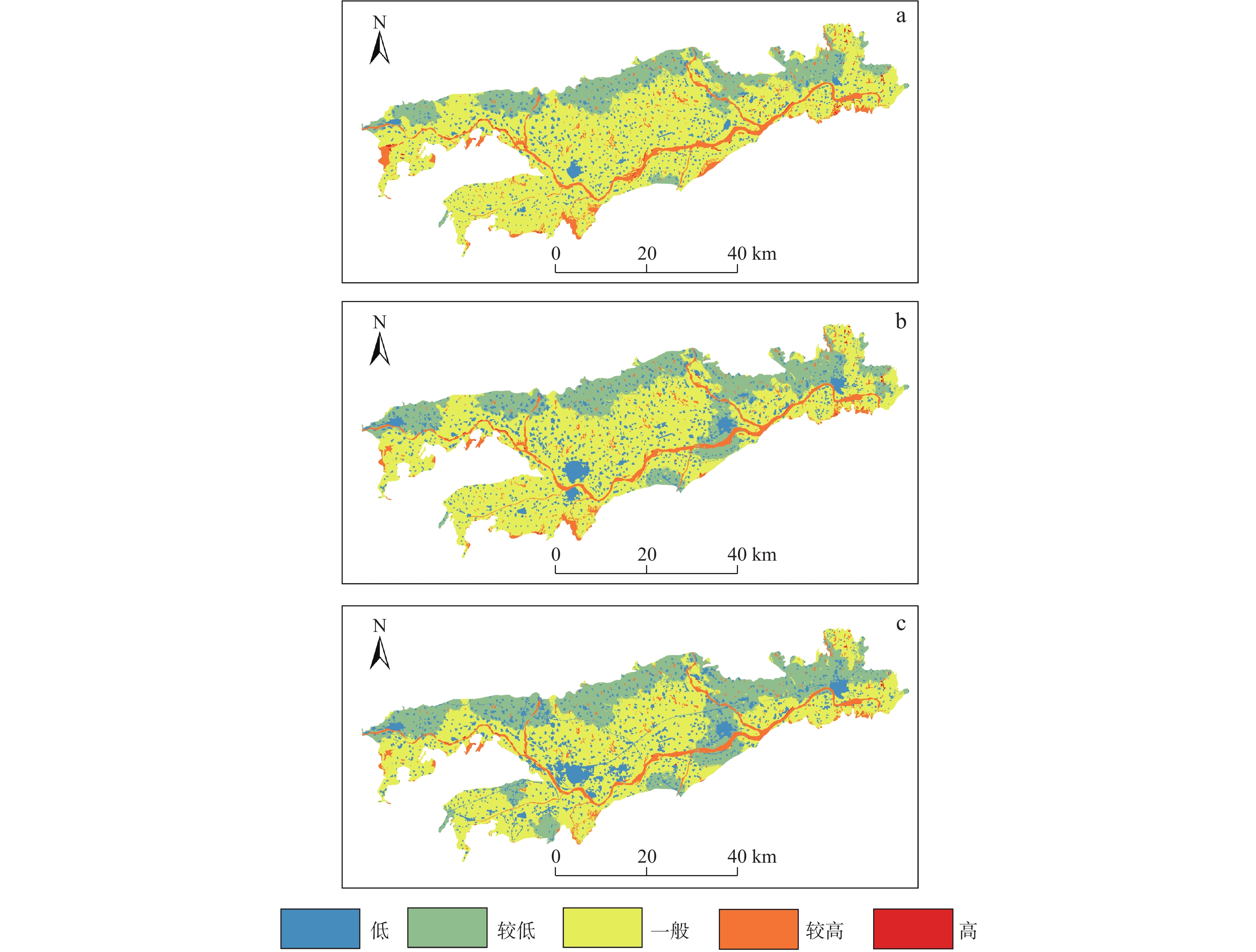
Figure 5.
Spatial and temporal variation map of habitat quality
-
Figure 6.
Temporal and spatial changes in land use expansion
-
Figure 7.
(a) Ranking of driving factors for expansion of construction land and(b) Analysis of the Contribution of Construction Land Expansion Factors
-
Figure 8.
Land use forecast analysis chart in 2030