
| Citation: |
FENG Minxuan, QI Qi, DONG Ying, ZENG Lei, ZHANG Xinshe, LIU Wenhui, LI Yong, WANG Tao, ZHANG Ge. 2023. Monitoring Surface Deformation in Xi’an City from 2019 to 2022 Based on Sentinel-1A Data. Northwestern Geology, 56(3): 178-185. doi: 10.12401/j.nwg.2023100

|
Monitoring Surface Deformation in Xi’an City from 2019 to 2022 Based on Sentinel-1A Data
-
Abstract
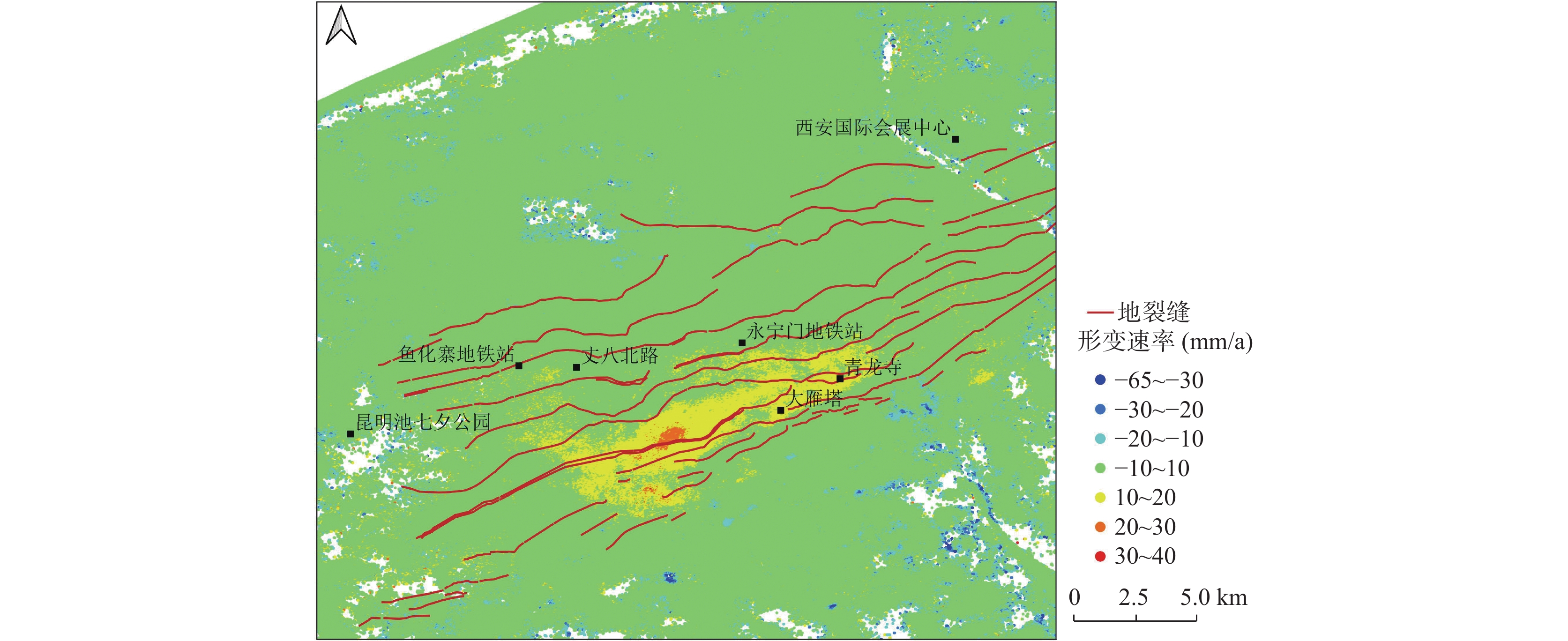
Xi’an is one of the areas in China where geological hazards such as ground subsidence and ground fissures are concentrated and developed. Ground subsidence in Xi’an is closely related to groundwater over–extraction. In recent years, groundwater levels have recovered as a result of the ongoing artificial recharge of groundwater in Xi’an. In this paper, 47 scenes of Sentinel-1A data from January 2019 to August 2022 in the urban area of Xi’an were processed using the small baseline subset InSAR technique to obtain the latest ground deformation characteristics of the Xi’an area. The main results obtained in this paper are as follows: with the groundwater level starting to rebound, ground subsidence in Xi’an has now been effectively alleviated, and ground rebound has been observed in typical subsidence areas such as Yuyuanzhai and Electronic City, etc. Extensive ground subsidence is hardly visible, and only scattered subsidence areas are seen in the southeast of the urban area. Changes in the groundwater table are an important cause of ground rebound. The surface uplift deformation in both the Electronic City area and the Yuhuazhai area has already passed the elastic deformation period of rapid soil deformation. The overall amount of rebound is within the safe range and the impact on the surrounding metro and buildings is limited.
-
Keywords:
- Xi’an /
- rebound deformation /
- groundwater /
- land subsidence /
- small baseline subsets InSAR technique
-

-
References
[1] 董英, 张茂省, 刘洁, 等. 2019. 西安市地下水与地面沉降地裂缝耦合关系及风险防控技术[J]. 西北地质, 52: 95-102 DONG Ying, ZhangMaosheng, Liu Jie et al. 2019. Coupling Relationship between Groundwater and Ground Fissures of Land Subsidence in Xi'an City and Risk Prevention and Control Technology[J]. . Northwestern Geology, 52(2): 95-102. [2] 廖明生, 王腾. 时间序列InSAR技术与应用[M]. 北京: 科学出版社, 2014. LIAO Mingsheng, WANG Teng. Time Series InSAR Technology and Applications[M]. Beijing: Science Press, 2014. [3] 彭建兵, 张勤, 黄强兵, 等. 西安地裂缝灾害[M]. 北京: 科学出版社, 2012. PENG Jianbing, ZHANG Qin, HUANG Qiangbing, et al. Xi'an Ground Fissure Geohazard [M]. Beijing: Science Press, 2012. [4] 冉培廉, 李少达, 杨晓霞, 等. 2021. 基于SBAS-InSAR技术的西安市地面沉降监测[J]. 河南理工大学学报(自然科学版), 40: 66-74 RAN Peilian, Li Shaoda, Yang Xiaoxia et al. Monitoring of Xi' an city land subsidence based on SBAS-InSAR[J]. Journal of Henan Poly technic University (Natural Science), 2021, 40 (3): 66-74. [5] 孙月敏, 杨天亮, 卢全中, 等. 2022. 基于SBAS-InSAR的西安市鱼化寨地区地面沉降与地裂缝时空演变特征研究[J]. 工程地质学报, 30: 553-564 SUN Yuemin, Yang Tianliang, Lu Quanzhong, et al. 2022. Spatial-temporal evolution characteristics of land subsidence and ground' fissure in Yuhua Village of Xi'an City using SBAS-InSAR technique [J]. Journal of Engineering Geology, 30(2): 553-564. [6] 王润泽, 费敏, 梁世川, 等. 2023. 基于SBAS-InSAR技术监测西安市地表形变特征[J]. 测绘通报: 173-178. Publishing, 2014 WANG Runze, Fei Min, Liang Shichuan et al. Monitoring of surface deformation characteristics in Xi'an based on SBAS-InSAR technology [J]. Bulletin of Surveying and Mapping, 2023, 0(1): 173-178. [7] 张勤, 赵超英, 丁晓利, 等. 2009. 利用GPS与InSAR研究西安现今地面沉降与地裂缝时空演化特征[J]. 地球物理学报, 52: 1214-1222. ZHANG Qin, Zhao Chaoying. Ding Xiaoli. et al. Research on recent characteristics of spatio-temporal evolution and mechanism of Xi'an land subsidence and ground fissure by using GPS and InSAR techniques[J]. Chinese J. Geophys, (in Chinese) , 2009, 52(5), 1214~1222. [8] 张勤, 黄观文, 杨成生. 2017. 地质灾害监测预警中的精密空间对地观测技术[J]. 测绘学报, 46: 1300-1307 doi: 10.11947/j.AGCS.2017.20170453 ZHANG Qin, Huang Guanwen, Yang Chengsheng. Precision Space Observation Technique for Geological Hazard Monitoring and Early Warning[J]. Acta Geodaetica et Cartographica Sinica, 2017, 46(10): 1300-1307. DOI:10.11947/j.AGCS.2017.20170453 [9] Berardino P, Fornaro G, Lanari R, et al. 2002. A New Algorithm for Surface Deformation Monitoring Based On Small Baseline Differential SAR Interferograms[J]. Ieee Transactions On Geoscience And Remote Sensing, 40: 2375-2383. [10] Feng M, Bie L, Rietbrock A. Probing the Rheology of Continental Faults: Decade of Post-Seismic InSAR Time-Series Following the 1997 Manyi (Xizang) Earthquake[J]. Geophysical Journal International, 2018, 215: 600−613. [11] Fielding E J, Blom R G, Goldstein R M. Rapid Subsidence Over Oil Fields Measured by SAR Interferometry[J]. Geophysical Research Letter, 1998, 25: 3215−3218. [12] Liu N, Huang Q, Wang L, et al. 2018. Dynamic Characteristics Research of a Ground Fissure Site at Xi’an, China[J]. Tunnelling And Underground Space Technology, 2018, 82: 182−190. [13] Massonnet D, Rossi M, Carmona C, et al. The Displacement Field of the Landers Earthquake Mapped by Radar Interferometry[J]. Nature, 1993, 364: 138−142. [14] Peng M, Zhao C, Zhang Q, et al. Research on Spatiotemporal Land Deformation (2012–2018) Over Xi’an, China with Multi-Sensor SAR Datasets[J]. Remote Sensing, 2019, 11(6): 664. [15] Qu F, Zhang Q, Lu Z, et al. Land Subsidence and Ground Fissures in Xi'an, China 2005–2012 Revealed by Multi-Band InSAR Time-Series Analysis[J]. Remote Sensing of Environment, 2014, 155: 366−376. [16] Shi W, Chen G, Meng X, et al. Spatial-Temporal Evolution of Land Subsidence and Rebound over Xi’an in Western China Revealed by SBAS-InSAR Analysis[J]. Remote Sensing, 2020, 12(22): 3756. [17] Wang B, Zhao C, Zhang Q, et al. Sequential InSAR Time Series Deformation Monitoring of Land Subsidence and Rebound in Xi’an, China[J]. Remote Sensing (Basel, Switzerland), 2019, 11: 2854. [18] Zhang Y, Wu J, Xue Y, et al. Land Subsidence and Uplift Due to Long-Term Groundwater Extraction and Artificial Recharge in Shanghai, China[J]. Hydrogeology Journal, 2015, 23: 1851−1866. -
Access History

Figures(9)

Export File
Citation
FENG Minxuan, QI Qi, DONG Ying, ZENG Lei, ZHANG Xinshe, LIU Wenhui, LI Yong, WANG Tao, ZHANG Ge. 2023. Monitoring Surface Deformation in Xi’an City from 2019 to 2022 Based on Sentinel-1A Data. Northwestern Geology, 56(3): 178-185. doi: 10.12401/j.nwg.2023100
Format
Content
 DownLoad:


-
Figure 1.
Research area and Sentinel-1A SAR data coverage
-
Figure 2.
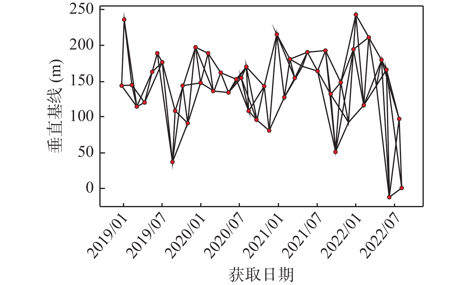
Spatial and temporal baseline distribution of SAR interferogram
-
Figure 3.
Annual deformation rate map of Xi’an from 2019 to 2022
-
Figure 4.
Annual deformation rate map of Yuhuazhai area from 2019 to 2022
-
Figure 5.
Cumulative deformation of Yuhuazhai area from 2015 to 2022
-
Figure 6.
Deformation analysis of Dianzicheng area
-
Figure 7.
Optical image of Yuhuazhai area
-
Figure 8.
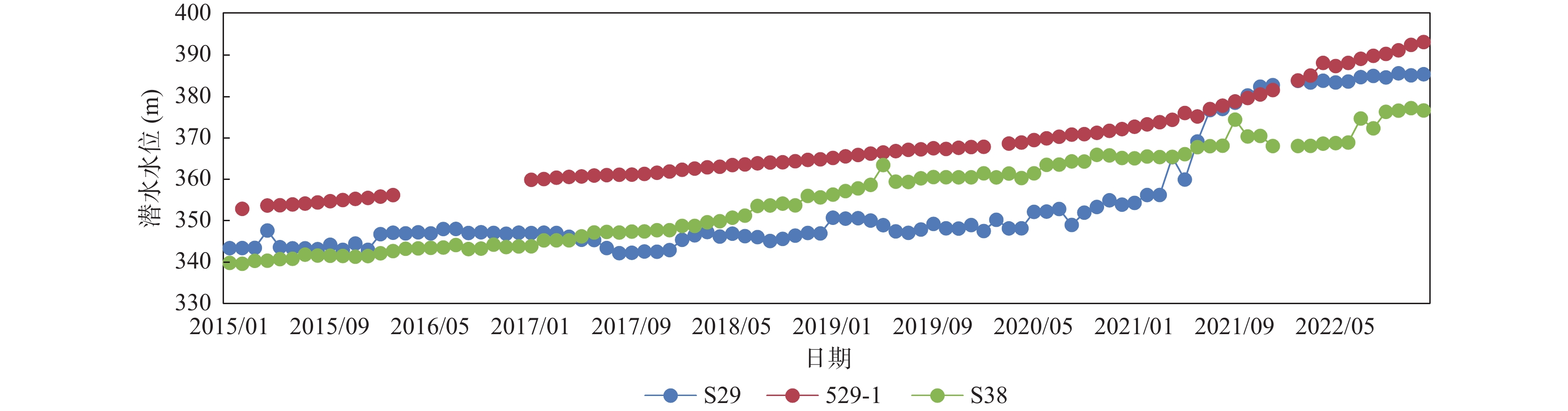
Groundwater levels variation of Dianzicheng area
-
Figure 9.
Comparison of cumulative deformation between the rapid uplift stage and the whole monitoring period