
| Citation: |
WANG Yingwei, ZHANG Yafeng, QIAN Xinyu, YANG Yunjun, CUI Jigang, YOU Jun, BIAN Xiaowei. 2023. Dynamic Evolution of Eco−geological Pattern: Taking Danjiangyuan Area of Central Line Project of South−to−North Water Diversion. Northwestern Geology, 56(3): 129-140. doi: 10.12401/j.nwg.2023083

|
Dynamic Evolution of Eco−geological Pattern: Taking Danjiangyuan Area of Central Line Project of South−to−North Water Diversion
-
Abstract
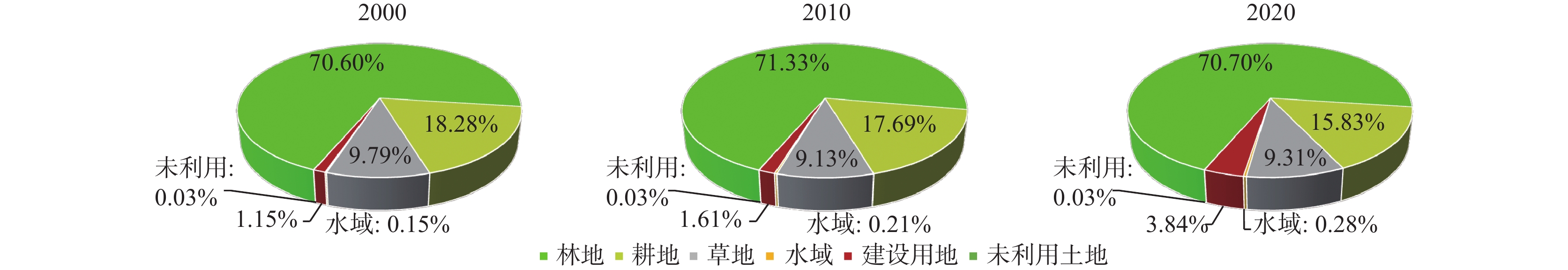
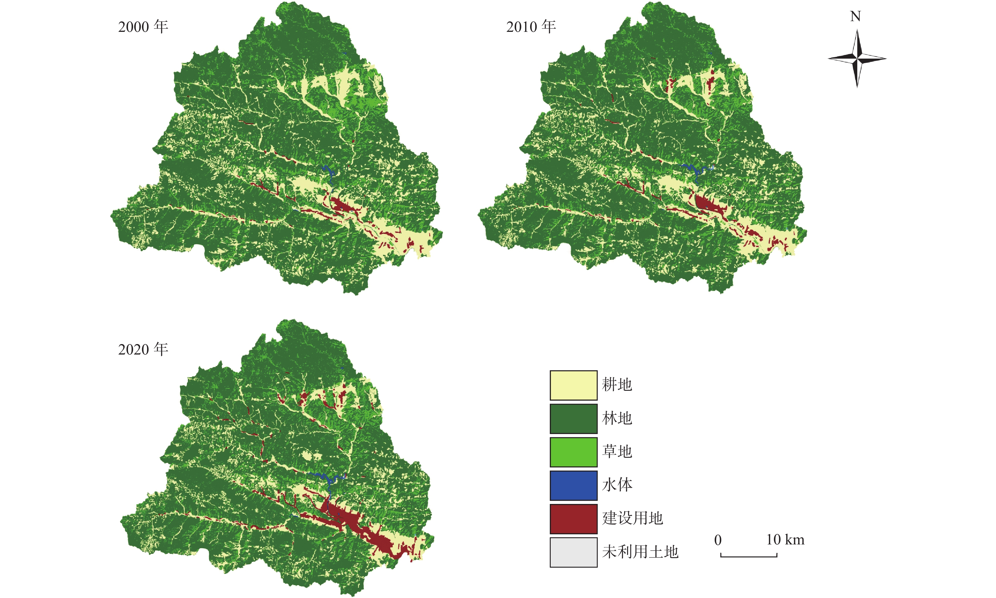
Taking Danjiangyuan area of central line project of south–to–north water diversion as the research area, the eco–geological characteristics of typical eco–critical zones in different geological formation were combed by slope survey. This paper extracts remote sensing data from 2000 to 2020 to interpret land use types and analyze the spatial and temporal evolution of land use and the evolution characteristics of landscape pattern with the help of ENVI 5.3, ArcGIS 10.2 and Fragstats4.2 software. The results show that each geological formation forms different landforms, soil parent material, soil types and hydrological types in vertical influenced by the structural geology setting. Different eco–geological patterns have been formed under the comprehensive influence of the above site conditions. The proportion of forest land is absolutely dominant, with forest land and arable land accounting for more than 85%, while the proportion of other land types is low. The types of land use changed significantly from the year of 2000 to 2020. Water area, cultivated land and construction land have changed dramatically. There are frequent transfers between natural landscapes and artificial landscapes in the area, and land use changes have less disturbance to the ecological environment. Forest and cultivated land are the main land use types of water source land for a long time, which directly affect their ecological and environmental effects. From 2000 to 2020, the landscape spatial pattern changed significantly, especially from 2010 to 2020, the landscape ecological process was more active. The patch types in the area tend to be distributed regularly and in a balanced trend, with good connectivity between patch types, the degree of landscape aggregation gradually increases, and the spatial distribution tends to be concentrated. The construction of central line project of south–to–north water diversion has further guaranteed the stable growth of the forest land base and water area in the study area, and the ecological trend in Danjiangyuan area is improving. Water transfer projects, urbanization construction and resettlement of protected water source areas have resulted in a substantial increase in construction land in the area, with grassland degradation and arable land reduction. It is suggested that rational allocation of land resources, optimization of land use structure, strengthening of forest land and cultivated land protection and ecological compensation will be conducive to the sustainable development of social economy and ecological environment in Danjiangyuan area.
-
Keywords:
- water conservation area /
- Danjiangyuan area /
- eco–geology /
- land use change /
- landscape pattern
-

-
References
[1] 陈利顶, 刘洋, 吕一河, 等. 景观生态学中的格局分析: 现状、困境与未来[J]. 生态学报, 2008, (11): 5521-5531 doi: 10.3321/j.issn:1000-0933.2008.11.037 CHEN Liding, LIU Yang, LÜ Yihe, et al. Landscape pattern analysis in landscape ecology: current, challenges and future[J]. Acta Ecologica Sinica, 2008, (11): 5521-5531. doi: 10.3321/j.issn:1000-0933.2008.11.037 [2] 陈利顶, 孙然好, 刘海莲. 城市景观格局演变的生态环境效应研究进展[J]. 生态学报, 2013, 33(4): 1042⁃ 1050. CHEN Liding, SUN Ranhao, LIU Hailian. Eco-environmental effects of urban landscape pattern changes: progress’ problems’ and perspectives[J]. Acta Ecologica Sinica, 2013, 33(4): 1042-1050 . [3] 陈文波, 肖笃宁, 李秀珍. 景观指数分类、应用及构建研究[J]. 应用生态学报, 2002, 13(01): 121-125 CHEN Wenbo, XIAO Duning, LI Xiuzhen. Classification, application, and creation of landscape indices[J]. Chinese Journal of Applied Ecology. 2002, 13(01): 121-125. [4] 中国科学院计算机网络信息中心科学数据中心. 地理空间数据[DB]. 地理空间数据云官网. http://www.gscloud.cn [5] 国家气象科学数据中心. 中国地面气候资料月值数据集[DB]. 国家气象科学数据中心, 1951−2020. [6] 何鹏, 张会儒. 常用景观指数的因子分析和筛选方法研究[J]. 林业科学研究, 2009, 22(04): 470-474 doi: 10.3321/j.issn:1001-1498.2009.04.002 HE Peng, ZHANG Huiru. Study on factor analysis and selection of common landscape metrics[J]. Forest Research, 2009, 22(04): 470-474. doi: 10.3321/j.issn:1001-1498.2009.04.002 [7] 李文明, 李健强, 徐永, 等. 西北生态地质调查研究进展与展望[J]. 西北地质, 2022, 55(03): 108-119 LI Wenming, LI Jianqiang, XU Yong, LIU Tuo, et al. Progress and Prospects of Ecological Geological Survey in Northwest China [J]. Northwestern Geology, 2022, 55(03): 108-119. [8] 李煜东, 臧传富, 陈相龙. 淮河流域 1990-2015年间土地利用时空变化特征及驱动机制研究[J]. 生态科学, 2020, 39(02): 104-113 LI Yudong, ZANG Chuanfu, CHEN Xianglong. Research on temporal and spatial variation characteristics and driving mechanism of land use in Huaihe River Basin from 1990 to 2015[J]. Ecological Science, 2020, 39(02): 104–113. [9] 聂洪峰, 肖春蕾, 戴蒙, 等. 生态地质调查工程进展与主要成果[J]. 中国地质调查, 2021, 8(01): 1-12 doi: 10.19388/j.zgdzdc.2021.01.01 NIE Hongfeng, XIAO Chunlei, DAI Meng, et al. Progresses and main achievements of ecological survey project[J]. Geological Survey of China, 2021, 8(01): 1-12. doi: 10.19388/j.zgdzdc.2021.01.01 [10] 潘贤章, 施建平. 全国第二次土壤普查典型土种的剖面数据库(1980-1996)[DB]. 国家地球系统科学数据共享平台-土壤科学数据中心, 2015 [11] 陕西师范大学地理系. 陕西省商洛地区地理志[M]. 西安: 陕西人民出版社. 1981. Department of Geography, Shaanxi Normal University. Geography of Shangluo, Shaanxi Province [M]. Xi’an: Shaanxi People’s Publishing House, 1981. [12] 苏明伟, 张伟峰, 杜鹃, 等. 2010-2018年陕西省LUCC动态变化分析[J]. 湖北农业科学, 2021, 60(05): 29-34 SU Mingwei, ZHANG Weifeng, DU Juan, et al. Analysis on the dynamic changes of LUCC in Shaanxi province from 2010 to 2018[J]. Hubei Agricultural Sciences, , 2021, 60(05): 29-34. [13] 孙天成, 刘婷婷, 褚琳, 等. 三峡库区典型流域“源”“汇”景观格局时空变化对侵蚀产沙的影响[J]. 生态学报, 2019, 39(20): 7476-7492 SUN Tiancheng, LIU Tingting, CHU Lin, et al. Effects of temporal and spatial variations in source-sink landscape patterns on soil erosion and sediment yield from typical watershed in the Three Gorges Reservoir area, China[J]. Acta Ecologica Sinca, 2019, 39(20): 7476-7492. [14] 王京彬, 卫晓锋, 张会琼, 等. 基于地质建造的生态地质调查方法-以河北省承德市国家生态文明示范区综合地质调查为例[J]. 中国地质, 2020, 47(06): 1611-1624 WANG Jingbin, WEI Xiaofeng, ZHANG Huixiong, et al. The eco-geological survey based on geological formation, exemplified by integrated geological survey of National Ecological Civilization Demonstration Area in Chengde City, Hebei Province[J]. Geology in China, 2020, 47(06): 1611-1624. [15] 王天山, 郑寒. 城市化过程中环洱海区域土地利用及景观格局变化分析[J]. 生态经济, 2016, 32(01); 181-185. WANG Tianshan, ZHEGN Han. Analysis of land use and landscape pattern change in Erhai lake during rapid urbanization[J]. Ecological economy, 2016, 32(01): 181-185. [16] 王尧, 张茂省, 杨建锋. 中国地质环境脆弱性评价[J]. 西北地质, 2019, 52(02): 198-206 WANG Yao, ZHANG Maosheng, YANG Jianfeng. Evaluation Research on the Fragility of Geological Environment in China[J]. Northwestern Geology, 2019, 52(2): 198-206. [17] 邬建国. 景观生态学: 格局、过程、尺度与等级[M]. 北京: 高等教育出版社, 2000 WU Jianguo. Landscape ecology: pattern, process, scale and hierarchy[M]. Beijing: Higher Education Press, 2000 [18] 岳德鹏, 王计平, 刘永兵, 等. GIS与RS技术支持下的北京西北地区景观格局优化[J]. 地理学报, 2007, (11): 1223-1231 YUE Depeng, WANG Jiping, LIU Yongbing, et al. , Landscape pattern optimization based on RS and GIS in northwest of beijing[J]. Acta Geographica Sinica, 2007, (11): 1223-1231. [19] 张建, 雷刚, 漆良华, 等. 2003-2018年土地利用变化对丹江口市景观格局与生态服务价值的影响[J]. 生态学报, 2021, 41(04): 1280-1290 ZHANG Jian, LEI Gang, Qi Lianghua, , et al. The landscape pattern and ecological service value in Danjiangkou City under land use change from 2003 to 2018. Acta Ecologica Sinica, 2021, 41(04): 1280-1290. [20] 张林, 李来新, 马东民, 等. 景观格局及生态系统服务价值响应-以千阳县为例[J]. 西北地质, 2022, 55(01): 274-283 ZHANG Lin, LI Laixin, MA Dongmin, et al. On the Landscape Pettern Change and the Ecological Service Value Response: Taking Qianyang County as an Example[J]. Northwestern Geology, 2022, 55(01): 274-283. [21] 张茂省, 王尧, 薛强. 资源环境承载力评价理论方法与实践[J]. 西北地质, 2019, 52(02): 1-11 ZHANG Maosheng, WANG Yao, XUE Qiang. Evaluation of Resource Environment Carrying Capacity: Theoretical Method and Practice[J]. Northwestern Geology, 2019, 52(2): 1-11. [22] 张晓宁, 刘学录, 王全喜, 等. 盐池县土地利用自然生态位变化及其对景观格局的影响[J]. 生态科学, 2020, 39(01): 156-163 ZHANG Xiaoning, LIU Xuelu, WANG Quanxi, et al. The change of natural niche of land use and its influence on landscape pattern of Yanchi County[J]. Ecological Science, 2020, 39(01): 156-163. [23] 张雁, 李占斌, 刘建林. 南水北调中线商洛水源地生态安全评价[J]. 人民长江, 2016, 47(19): 32-36 ZHANG Yan, LI Zhanbin, LIU Jianlin. Ecological safety assessment on Shangluo water area of Middle Route Project of South-to-North Water Diversion [J]. Yangtze River, 2016, 47(19): 32-36. [24] 张雁. 山区水源地建设的生态环境效应评价与保护研究[D]. 西安: 西安理工大学, 2018 ZHANG Yan. Ecological environmental assessment and protection of water source construction projects in mountainous area: a case study in Shagnluo water source area[D]. Xi’an: Xi’an University of Technology, 2018. [25] CHEN Fei, CHEN Jun, and WU Hao, et al. 2016. A landscape shape index-based sampling approach for land cover accuracy assessment[J]. Science China Earth Sciences, 2016, 59: 2263-2274. doi: 10.1007/s11430-015-5280-5 [26] CHEN Jin, ZHU Xiaolin, and Vogelmann James E. , et al. A simple and effective method for filling gaps in Landsat ETM SLC-off images[J]. Remote Sensing of Environment, 2011, 115(4): 1053-1064. doi: 10.1016/j.rse.2010.12.010 [27] CHEN Jun, BAN Yifang, LI Songnian. China: Open access to Earth land-cover map[J]. Nature, 2014, 514(7523): 434-434. [28] Moser D, Zechmeister H G, Plutzar C, et al. Landscape patch shape complexity as an effective measure for plant species richness in rural landscapes[J]. Landscape Ecology, 2002, 17(7): 657-669. [29] Robert Costanza. Ecological Economies: reintegrating the study of humans and nature[J]. Nature Sciences Société, 1997, 5(2): 90 [30] Veldkamp A, Verburg P H. Modelling land use change and environmental impact[J]. Journal of Environmental Management, 2004, 72(1-2S1): 1-3. [31] ZHU Xiaolin, CHEN Jin, and Gao Feng, et al. An enhanced spatial and temporal adaptive reflectance fusion model for complex heterogeneous regions[J]. Remote Sensing of Environment, 2010, 114(11): 2610-2623. doi: 10.1016/j.rse.2010.05.032 -
Access History

Figures(7)
Tables(4)

Export File
Citation
WANG Yingwei, ZHANG Yafeng, QIAN Xinyu, YANG Yunjun, CUI Jigang, YOU Jun, BIAN Xiaowei. 2023. Dynamic Evolution of Eco−geological Pattern: Taking Danjiangyuan Area of Central Line Project of South−to−North Water Diversion. Northwestern Geology, 56(3): 129-140. doi: 10.12401/j.nwg.2023083
Format
Content
 DownLoad:


-
Figure 1.
(a) Geographical location of the study area and (b) drainage distribution map of Danjiangyuan Area
-
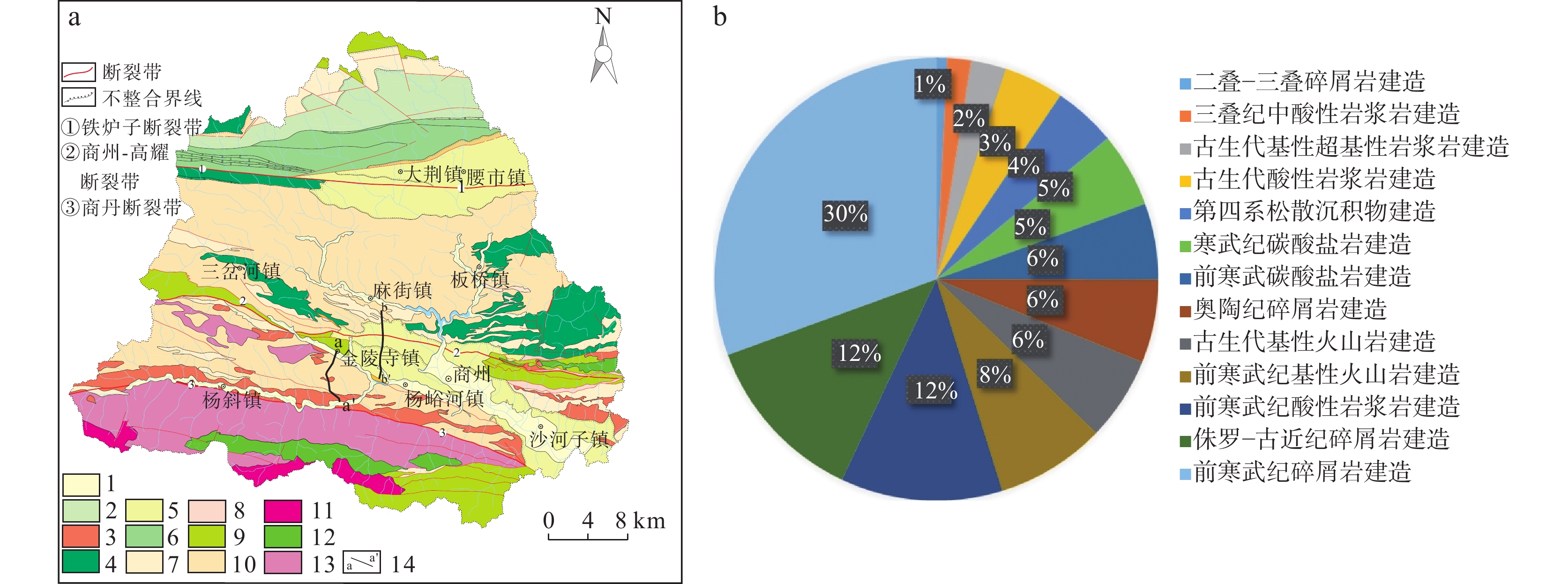
Figure 2.
(a) Geological construction map and (b) distribution map of different geological construction areas in Danjiangyuan area
-
Figure 3.
Changes of bedrock, parent material, soil and vegetation in different ecological key zones of Danjiangyuan area
-
Figure 4.
Eco–geological profile of Jinlingsi Town–Shizyuan Street in Danjiangyuan area
-
Figure 5.
Eco–geological profile of Majeiling–Renjia village in Yangyuhe town, Danjiangyuan area
-
Figure 6.
Quantitative structure of different land use types of Danjiangyuan area in 2000, 2010 and 2020
-
Figure 7.
Remote sensing interpretation changes of land use types of Danjiangyuan area in 2000, 2010 and 2020