
| Citation: |
FENG Wei, TANG Yaming, JIA Jun, MA Hongna, LI Yan’e, HONG Bo, XUE Qiang, TANG Zhuo. 2023. A Method for Optimizing Territorial Space Planning of Mountain Towns Based on Geological Hazard Risk Assessment. Northwestern Geology, 56(3): 232-238. doi: 10.12401/j.nwg.2023074

|
A Method for Optimizing Territorial Space Planning of Mountain Towns Based on Geological Hazard Risk Assessment
-
Abstract
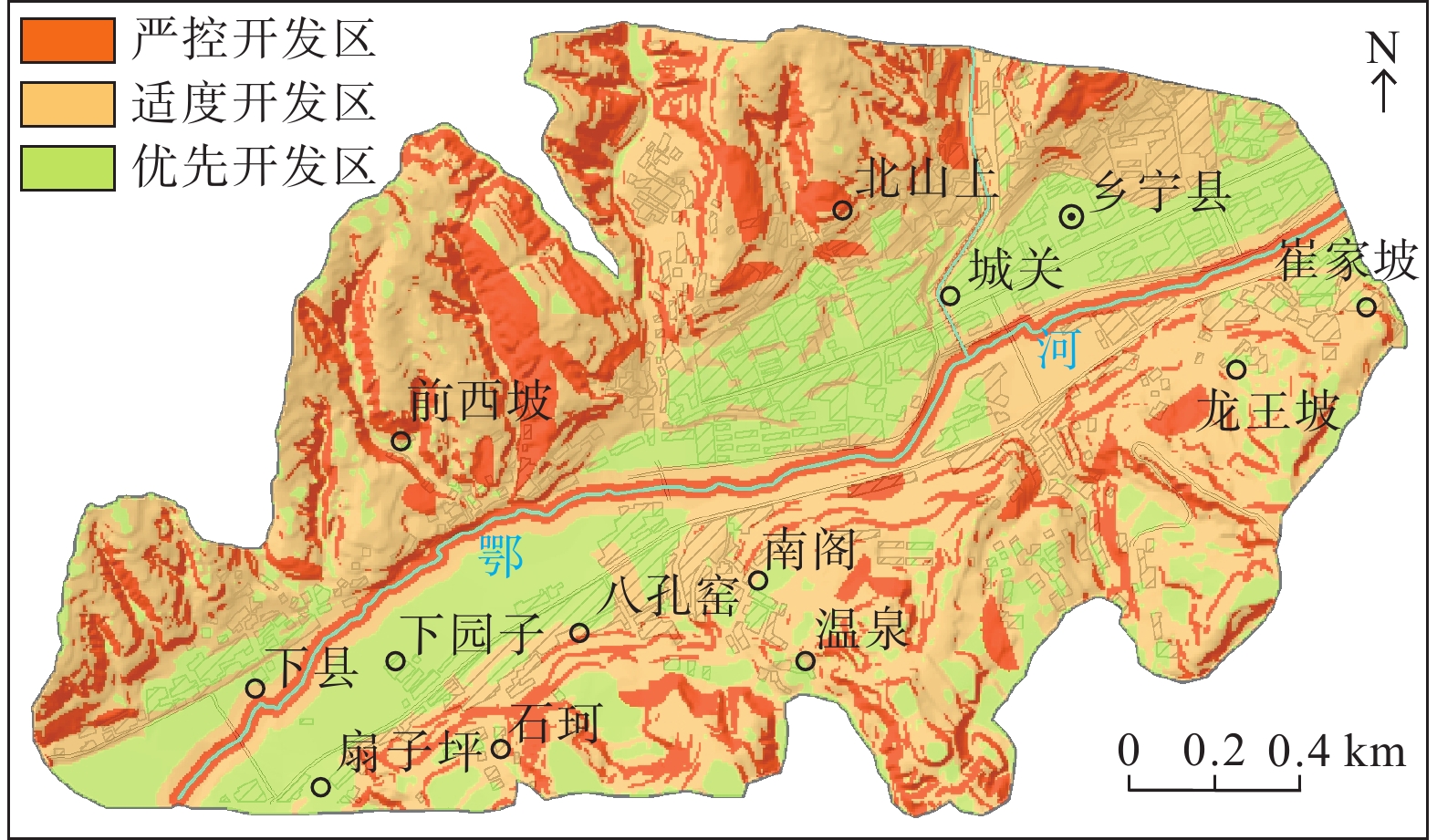
Taking Fanziping–Cuijiapo section of Xiangning County, Shanxi Province as an example, a method of optimizing territorial spatial planning based on geological hazard risk assessment is proposed by combining “barrel effect” theory with “double–control of point and zone” system of geological disaster risk. This method is based on 1∶10,000 geological disaster risk assessment and combined with “double–control of point and zone” system of geological disaster risk, taking slope, river distance, geological disaster risk zoning and disaster range of geological disaster hidden danger point as the short board factors in the barrel effect. According to the order of strictly controlled development zone, moderate development zone and priority development zone from high to low, the highest grade value of each weakness factor in the same plot is taken as the result value of optimizing
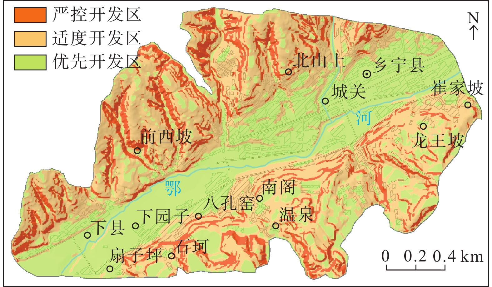
territorial space planning of the plot. The results show that strictly controlled development zones in the study area account for 26.67%, moderate development zones account for 54.81%, and priority development zones account for 18.52%. Theoretically, it shows that the study area is dominated by priority development zones and moderate development zones, which has great development potential. The proposed optimization method can conveniently and effectively complete territorial space planning in large scale mountainous areas, and the research results can provide a reference for similar areas to carry out territorial space planning.
-

-
References
[1] 陈霆, 徐伟铭, 吴升, 等. 国土空间规划视角下的城镇开发边界划定和空间管控体系构建[J]. 地球信息科学学报, 2022, 24(2): 263-279 CHEN Ting, XU Weiming, WU Sheng, et al. Delimitation of urban development boundary and construction of space control system from the perspective of territorial spatial planning[J]. Journal of Geo-information Science, 2022, 24(2): 263-279. [2] 高晓路, 吴丹贤, 周侃, 等. 国土空间规划中城镇空间和城镇开发边界的划定[J]. 地理研究, 2019, 38(10): 2458-2472 GAO Xiaolu, WU Danxian, ZHOU Kan, et al. The urban space and urban development boundary under the framework of territory spatial planning[J]. Geographical Research, 2019, 38(10): 2458-2472. [3] 江思义, 吴福, 刘庆超, 等. 岩溶地区建设用地地质环境适宜性评价——以广西桂林规划中心城区为例[J]. 中国地质灾害与防治学报, 2019, 30(06): 84-93 JIANG Siyi, WU Fu, LIU Qingchao, et al. Suitability evaluation of construction land development in karst area: taking city planning center of Guilin as an example[J]. The Chinese Journal of Geological Hazard and Control, 2019, 30(06): 84-93. [4] 马云飞, 邹芳, 徐海燕. 基于地质灾害风险评价的衡东县国土空间管制研究[J]. 地理信息世界, 2020, 27(6): 14-20 MA Yunfei, ZOU Fang, XU Haiyan. Land space control of hengdong county based on geological hazard risk assessment[J]. Geomatics World, 2020, 27(6): 14-20. [5] 沈悦, 刘天科, 周璞. 自然生态空间用途管制理论分析及管制策略研究[J]. 中国土地科学, 2017, 31(12): 17-24 doi: 10.11994/zgtdkx.20180108.143848 SHEN Yue, LIU Tianke, ZHOU Pu. Theoretical Analysis and Strategies of Natural Ecological Space Use Control[J]. China Land Sciences, 2017, 31(12): 17-24. doi: 10.11994/zgtdkx.20180108.143848 [6] 汤国安, 杨昕. ArcGIS地理信息系统空间分析实验教程[M]. 北京: 科学出版社, 2006: 429–445 TANG Guo’an, YANG Xin. ArcGIS Geographic Information system spatial analysis experiment tutorial[M]. Beijing: Science Press, 2006: 429–445. [7] 唐亚明, 薛强, 毕俊擘, 等. 陕北黄土崩塌灾害风险评价指标体系构建[J]. 地质通报, 2012a, 31(6): 979-988 TANG Yaming, XUE Qiang, BI Junbo, et al. The construction of factors for assessing the risk of collapse at loess slopes in northern Shaanxi Province[J]. Geological Bulletin of China, 2012a, 31(6): 979-988. [8] 唐亚明, 薛强, 李清, 等. 黄土滑塌灾害风险分级系统研究[J]. 工程地质学报, 2012b, 20(3): 378-386 TANG Yaming, XUE Qiang, LI Qing, et al. Slope classification system for loess collapse risk assessment[J]. Journal of Engineering Geology, 2012b, 20(3): 378-386. [9] 唐亚明, 张茂省, 李政国, 等. 国内外地质灾害风险管理对比及评述[J]. 西北地质, 2015, 48(2): 238-246 TANG Yaming, ZHANG Maosheng, LI Zhengguo, et al. Review and Comparison on Inland and Overseas Geo-hazards Risk Management[J]. Northwestern Geology, 2015, 48(2): 238-246. [10] 唐亚明. 从全球视角看城镇化进程中的土地利用模式[J]. 中国土地, 2016, 360(1): 47-48 TANG Yaming. Land use patterns in the process of urbanization from a global perspective[J]. China Land, 2016, 360(1): 47-48. [11] 铁永波, 徐伟, 向炳霖, 等. 西南地区地质灾害风险“点面双控”体系构建与思考[J]. 中国地质灾害与防治学报, 2022, 33(3): 106-113 TIE Yongbo, XU Wei, XIANG Binglin, et al. The thoughts on construction of “double-control of point and zone” system of geological hazard risk in southwest China[J]. The Chinese Journal of Geological Hazard and Control, 2022, 33(3): 106-113. [12] 张茂省, 刘江, 董英, 等. 国土空间优化中的关键地质要素分析与“双评价”方法[J]. 地学前缘, 2020, 27(04): 311-321 ZHANG Maosheng, LIU Jiang, DONG Ying, et al. Analysis of key geological factors and the “dual evaluation” method for land space optimization[J]. Earth Science Frontiers, 2020, 27(04): 311-321. [13] 张晓玲, 吕晓. 国土空间用途管制的改革逻辑及其规划响应路径[J]. 自然资源学报, 2020, 35(6): 1261-1272 doi: 10.31497/zrzyxb.20200601 ZHANG Xiaoling, LV Xiao. Reform logic of territorial space use regulation and the response path of land spatial planning[J]. Journal of Natural Resources, 2020, 35(6): 1261-1272. doi: 10.31497/zrzyxb.20200601 [14] 郑续, 苗俊霞, 王东, 等. 黄河中上游地质灾害高发县国土空间开发适宜性评价及功能分区——以陕西省延川县为例[J]. 西北地质, 2020, 53(02): 289-297 ZHENG Xu, MIAO Junxia, WANG Dong, et al. Suitability evaluation and functional division of land space development in the high-incidence area of geological hazards in the middle and upper reaches of the yellow river: a case study of Yanchuan County, Shaanxi Province[J]. Northwestern Geology, 2020, 53(02): 289-297. [15] 周启鸣, 刘学军. 数字地形分析[M]. 北京: 科学出版社, 2006: 52–70 ZHOU Qiming, LIU Xuejun. Digital terrain analysis[M]. Beijing: Science Press, 2006: 52–70. [16] 周伟, 马书红. 基于木桶理论的公路交通与经济发展适应性研究[J]. 中国公路学报, 2003(03): 78-83 ZHOU Wei, MA Shuhong. Adaptability study based on the barrel theory about highway transportation and economics[J]. China Journal of Highway and Transport, 2003(03): 78-83. [17] Hungr O, Corominas J, Eberhardt E. Estimating landslide motion mechanism, travel distance and velocity[A]. Hunger O, Fell R, Couture R. Proceedings of the International Conference on Landslide Risk Management[C]. London: Taylor and Francis, 2005: 108–115. [18] Wei Y D, Ye X. Urbanization, urban land expansion and environmental change in China[J]. Stochastic Environmental Research & Risk Assessment, 2014, 28(4): 757-765. -
Access History
Figures(8)
Tables(1)

Export File
Citation
FENG Wei, TANG Yaming, JIA Jun, MA Hongna, LI Yan’e, HONG Bo, XUE Qiang, TANG Zhuo. 2023. A Method for Optimizing Territorial Space Planning of Mountain Towns Based on Geological Hazard Risk Assessment. Northwestern Geology, 56(3): 232-238. doi: 10.12401/j.nwg.2023074
Format
Content
 DownLoad:

-
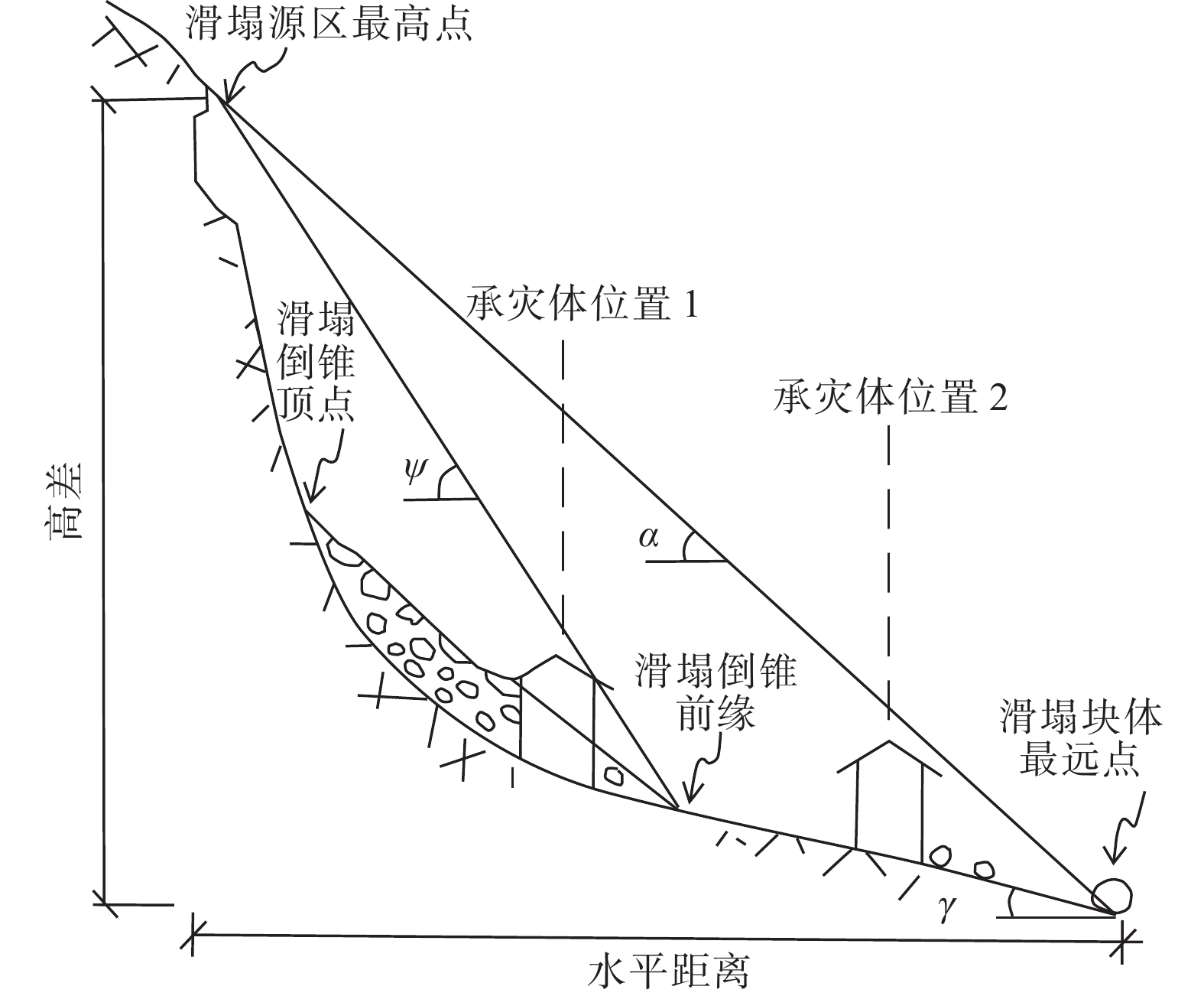
Figure 1.
Schematic diagram of the distance between the collapse sources and the elements in risk
-
Figure 2.
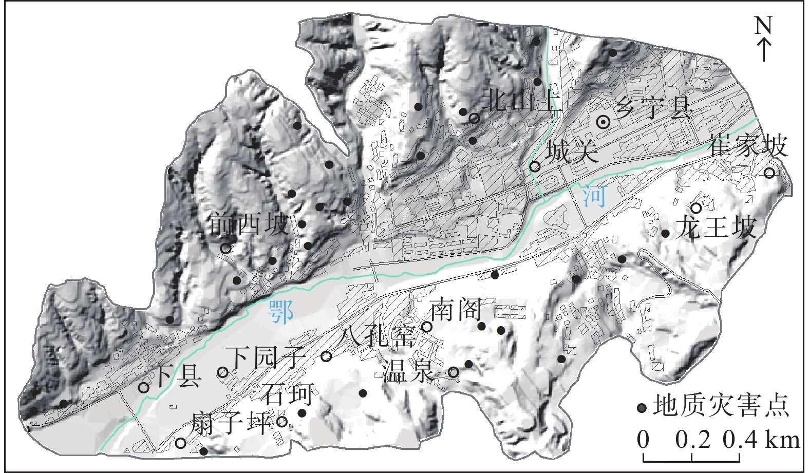
Geographical location map of the study area
-
Figure 3.
Geological disaster risk zoning map of the study area
-
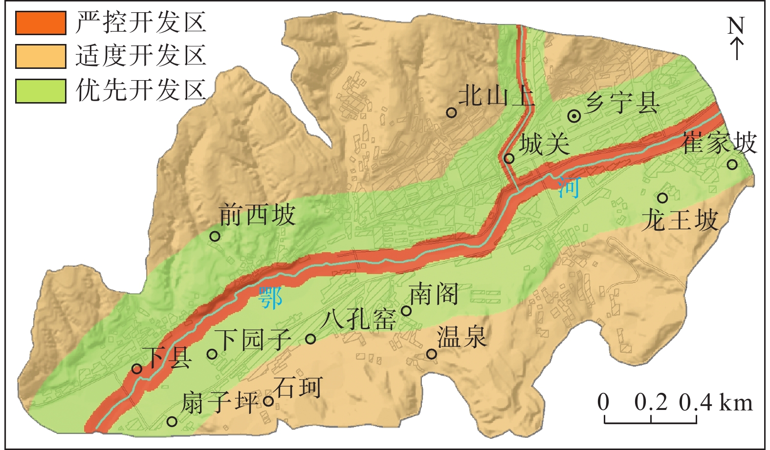
Figure 4.
Slope optimized grading map of the study area (single factor)
-
Figure 5.
River distance optimized grading map of the study area (single factor)
-
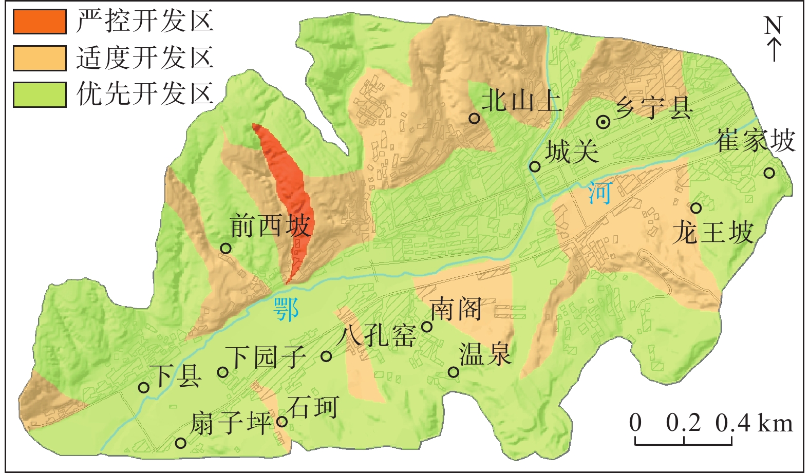
Figure 6.
Geological disaster risk zooning optimized grading map of the study area (single factor)
-
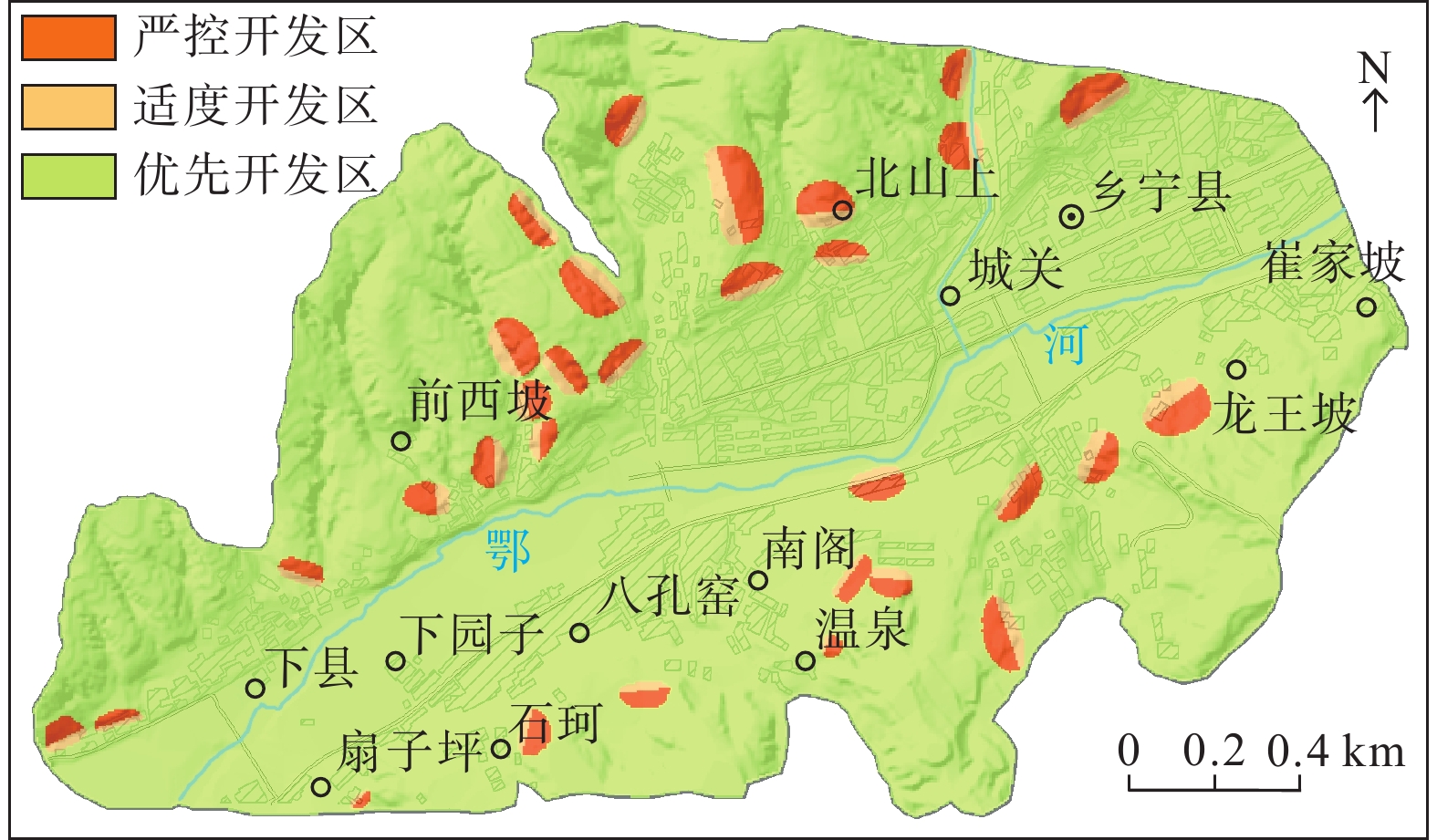
Figure 7.
Disaster range of geological disaster hidden danger point optimized grading map of the study area (single factor)
-
Figure 8.
Optimizing territorial space planning map of the study area (multi-factor synthesis)