
| Institute of Geomechanics, Chinese Academy of Geological Sciences | Host |
| Citation: |
BAI Luanxi, TAN Xibin, ZHOU Chao. 2022. Drainage divide stability at Wulashan, northern margin of the Ordos block, China: Evidence from the analysis of χ value. Journal of Geomechanics, 28(4): 513-522. doi: 10.12090/j.issn.1006-6616.2021128

|
Drainage divide stability at Wulashan, northern margin of the Ordos block, China: Evidence from the analysis of χ value
-
Abstract
The stability of drainage divides carries important tectonic and climatic information. However, there is still no consensus on the criterion for measuring the stability of drainage divides, which may lead to different conclusions. There are two different views on the stability of the divide at the Wulashan horst, northern margin of the Ordos block: The drainage divide is moving northward, according to the comparison of drainage-basin morphology (such as elbows of capture, knick points); The drainage divide remains stable, according to the comparison of Gilbert metrics. In this study, we used the χ-plot method to check both the stability of the Wulashan drainage divide and the reliability of the above methods. The analysis shows that the χ value at the top of the northern side is higher than that at the same elevation of the southern side if a lower baseline was set (1300 m a.s.l.); If a higher baseline (~1800 m a.s.l.) is set, the χ values on both sides of the divide are the same at the same elevation. Because the tilting has relatively less influence, the χ-plot with a higher baseline is more representative of the drainage divide stability. In summary, the result supports the view that the drainage divide at the Wulashan horst is at a steady state. Moreover, we discussed the limitations of the methods in measuring the stability of drainage divides.
-
Keywords:
- drainage divide /
- Wulashan horst /
- χ value /
- tilting
-

-
References
CASTELLTORT S, GOREN L, WILLETT S D, et al., 2012. River drainage patterns in the New Zealand Alps primarily controlled by plate tectonic strain[J]. Nature Geoscience, 5(10): 744-748. doi: 10.1038/ngeo1582 CHEN L C, 2002. Paleoearthquakes, the law of strong earthquake recurrence and potential sites for the occurrence of future strong earthquakes in the Hetao fault-depression zone[D]. Beijing: Institute of Geology, China Earthquake Administration. (in Chinese with English abstract) DENG Q D, CHENG S P, MIN W, et al., 1999. Discussion on Cenozoic tectonics and dynamics of Ordos block[J]. Journal of Geomechanics, 5(3): 13-21. (in Chinese with English abstract) DENG Q D, LIAO Y H, 1996. Paleoseismology along the range-front fault of Helan Mountains, north central China[J]. Journal of Geophysical Research: Solid Earth, 101(B3): 5873-5893. doi: 10.1029/95JB01814 FORTE A M, WHIPPLE K X, 2018. Criteria and tools for determining drainage divide stability[J]. Earth and Planetary Science Letters, 493: 102-117. doi: 10.1016/j.epsl.2018.04.026 FORTE A M, WHIPPLE K X, 2019. Short communication: The Topographic Analysis Kit (TAK) for TopoToolbox[J]. Earth Surface Dynamics, 7(1): 87-95. doi: 10.5194/esurf-7-87-2019 GILBERT G K, 1877. Geology of the Henry mountains[R]. Washington: Government Printing Office. GOREN L, WILLETT S D, HERMAN F, et al., 2014. Coupled numerical-analytical approach to landscape evolution modeling[J]. Earth Surface Processes and Landforms, 39(4): 522-545. doi: 10.1002/esp.3514 HE C Q, CHENG Y L, RAO G, et al., 2018. Geomorphological signatures of the evolution of active normal faults along the Langshan Mountains, North China[J]. Geodinamica acta, 30(1): 163-182. doi: 10.1080/09853111.2018.1458935 HE C Q, RAO G, YANG R, et al., 2019. Divide migration in response to asymmetric uplift: Insights from the Wula Shan horst, North China[J]. Geomorphology, 339: 44-57. doi: 10.1016/j.geomorph.2019.04.024 HE C Q, YANG C J, TUROWSKI J M, et al., 2021. Constraining tectonic uplift and advection from the main drainage divide of a mountain belt[J]. Nature communications, 12(1): 544. doi: 10.1038/s41467-020-20748-2 HE Z T, MA B Q, HAO Y J, et al., 2020. Surface rupture geomorphology and vertical slip rates constrained by terraces along the Wulashan piedmont fault in the Hetao Basin, China[J]. Geomorphology, 358: 107116. doi: 10.1016/j.geomorph.2020.107116 BEESON H W, MCCOY S W, KEEN-ZEBERT A, 2017. Geometric disequilibrium of river basins produces long-lived transient landscapes[J]. Earth and Planetary Science Letters, 475: 34-43. doi: 10.1016/j.epsl.2017.07.010 HOWARD A D, 1994. A detachment-limited model of drainage basin evolution[J]. Water resources research, 30(7), 2261-2285. doi: 10.1029/94WR00757 KIRBY E, WHIPPLE K, 2001. Quantifying differential rock-uplift rates via stream profile analysis[J]. Geology, 29(5): 415-418. doi: 10.1130/0091-7613(2001)029<0415:QDRURV>2.0.CO;2 KIRBY E, WHIPPLE K X, 2012. Expression of active tectonics in erosional landscapes[J]. Journal of Structural Geology, 44: 54-75. doi: 10.1016/j.jsg.2012.07.009 KIRBY J R, PARRILA R K, PFEIFFER S L, 2003. Naming speed and phonological awareness as predictors of reading development[J]. Journal of Educational Psychology, 95(3): 453-464. doi: 10.1037/0022-0663.95.3.453 LI J B, RAN Y K, GUO W S, 2007. Division of Quaternary beds and environment evolution in Hubao basin in China[J]. Quaternary Sciences, 27(4): 632-644. (in Chinese with English abstract) LI Y B, RAN Y K, CHEN L C, et al., 2015. The latest surface rupture events on the major active faults and great historical earthquakes in Hetao fault-depression zone[J]. Seismology and Geology, 37(1): 110-125. (in Chinese with English abstract) LIN L L, LI X M, ZHANG H P, et al., 2021. River capture and divide migration of the Zhuozishan area in the northwestern margin of the Ordos Block[J]. Journal of Geomechanics, 27 (2): 294-303. (in Chinese with English abstract) LIU Y D, TAN X B, YE Y J, et al., 2020. Role of erosion in creating thrust recesses in a critical-taper wedge: An example from Eastern Tibet[J]. Earth and Planetary Science Letters, 540: 116270. doi: 10.1016/j.epsl.2020.116270 PERRON J T, ROYDEN L, 2013. An integral approach to bedrock river profile analysis[J]. Earth Surface Processes and Landforms, 38(6): 570-576. doi: 10.1002/esp.3302 RAN Y K, CHEN L C, YANG X P, et al., 2003. Recurrence characteristics of late Quaternary strong earthquakes on the major active faults along the northern border of Ordos Block[J]. Science in China (Series D): Earth Sciences, 46(2): 189-200. . (in Chinese with English abstract) RAO G, LIN A M, YAN B, et al., 2014. Tectonic activity and structural features of active intracontinental normal faults in the Weihe Graben, central China[J]. Tectonophysics, 636: 270-285. doi: 10.1016/j.tecto.2014.08.019 RAO G, LIN A M, YAN B, 2015. Paleoseismic study on active normal faults in the southeastern Weihe Graben, central China[J]. Journal of Asian Earth Sciences, 114: 212-225. doi: 10.1016/j.jseaes.2015.04.031 RAO G, CHEN P, HU J M, et al., 2016. Timing of Holocene paleo-earthquakes along the Langshan Piedmont Fault in the western Hetao Graben, North China: Implications for seismic risk[J]. Tectonophysics, 677-678: 115-124. doi: 10.1016/j.tecto.2016.03.035 RAO G, HE C Q, CHENG Y L, et al., 2018. Active normal faulting along the Langshan Piedmont Fault, North China: Implications for slip partitioning in the western Hetao Graben[J]. The Journal of Geology, 126(1): 99-118. doi: 10.1086/694748 SCHWANGHART W, SCHERLER D, 2014. Short Communication: TopoToolbox 2-MATLAB-based software for topographic analysis and modeling in Earth surface sciences[J]. Earth Surface Dynamics, 2 (1): 1-7. doi: 10.5194/esurf-2-1-2014 SHI F, TAN X B, ZHOU C, et al., 2021. Impact of asymmetric uplift on mountain asymmetry: Analytical solution, numerical modeling, and natural examples[J]. Geomorphology, 389: 107862. doi: 10.1016/j.geomorph.2021.107862 SU Q, WANG X Y, LU H Y, et al., 2020. Dynamic Divide Migration as a Response to Asymmetric Uplift: An Example from the Zhongtiao Shan, North China[J]. Remote Sensing, 12(24): 4188. doi: 10.3390/rs12244188 STOKES M F, GOLDBERG S L, PERRON J T, 2018. Ongoing river capture in the Amazon[J]. Geophysical Research Letters, 45(11): 5545-5552. doi: 10.1029/2018GL078129 STRUTH L, GARCIA-CASTELLANOS D, VIAPLANA-MUZAS M, et al., 2019. Drainage network dynamics and knickpoint evolution in the Ebro and Duero basins: From endorheism to exorheism[J]. Geomorphology, 327: 554-571. doi: 10.1016/j.geomorph.2018.11.033 The Research Group on Active Fault System around Ordos Massif, State Seismological Bureau (RGAFSO), 1988. Active fault system Around Ordos Massif[M], Beijing, China: Seismological Press: 1-335. (in Chinese) TUCKER G E, SLINGERLAND R, 1997. Drainage basin responses to climate change[J]. Water Resources Research, 33(8): 2031-2047. doi: 10.1029/97WR00409 VACHERAT A, BONNET S, MOUTHEREAU F, 2018. Drainage reorganization and divide migration induced by the excavation of the Ebro basin (NE Spain)[J]. Earth Surface Dynamics, 6(2): 369-387. doi: 10.5194/esurf-6-369-2018 WHIPPLE K X, FORTE A M, DIBIASE R A, et al., 2017. Timescales of landscape response to divide migration and drainage capture: Implications for the role of divide mobility in landscape evolution[J]. Journal of Geophysical Research: Earth Surface, 122(1): 248-273. doi: 10.1002/2016JF003973 WHIPPLE K X, TUCKER G E, 1999. Dynamics of the stream-power river incision model: Implications for height limits of mountain ranges, landscape response timescales, and research needs[J]. Journal of Geophysical Research: Solid Earth, 104(B8): 17661-17674. doi: 10.1029/1999JB900120 WILLETT S D, MCCOY S W, PERRON J T, et al., 2014. Dynamic reorganization of river basins[J]. Science, 343(6175): 1248765. doi: 10.1126/science.1248765 WOBUS C, WHIPPLE K X, KIRBY E, et al., 2006. Tectonics from topography: Procedures, promise, and pitfalls[M]//WILLETT S D, HOVIUS N, BRANDON M T, et al. Tectonics, Climate, and Landscape Evolution. Boulder: geological society of America, 55-74. WU L J, SHI J S, ZHANG Y, L et al., 2020. Ostracod characteristics of the eastern Hetao Basin and its sedimentary environmental significance during the Middle and Late Quaternary. Journal of Geomechanics, 26 (1): 125-134. (in Chinese with English abstract) XU Y R, HE H L, DENG Q D, et al., 2018. The CE 1303 Hongdong earthquake and the Huoshan Piedmont fault, Shanxi graben: Implications for magnitude limits of normal fault earthquakes[J]. Journal of Geophysical Research: Solid Earth, 123(4): 3098-3121. doi: 10.1002/2017JB014928 YANITES B J, EHLERS T A, BECKER J K, et al., 2013. High magnitude and rapid incision from river capture: Rhine River, Switzerland[J]. Journal of Geophysical Research: Earth Surface, 118(2): 1060-1084. doi: 10.1002/jgrf.20056 ZHENG W J, ZHANG P Z, YUAN D Y, et al., 2019. Basic characteristics of active tectonics and associated geodynamic processes in continental China[J]. Journal of Geomechanics, 25(5): 699-721. (in Chinese with English abstract) ZHOU C, TAN X B, LIU Y D, et al., 2022a. A cross-divide contrast index (C) for assessing controls on the main drainage divide stability of a mountain belt[J]. Geomorphology, 398: 108071. doi: 10.1016/j.geomorph.2021.108071 ZHOU C, TAN X B, LIU Y D, et al., 2022b. Ongoing Westward Migration of Drainage Divides in Eastern Tibet, Quantified from Topographic Analysis[J]. Geomorphology, 402: 108123. doi: 10.1016/j.geomorph.2022.108123 陈立春, 2002. 河套断陷带的古地震、强震复发规律和未来可能强震地点[D]. 北京: 中国地震局地质研究所. 邓起东, 程绍平, 闵伟, 等, 1999. 鄂尔多斯块体新生代构造活动和动力学的讨论[J]. 地质力学学报, 5(3): 13-21. doi: 10.3969/j.issn.1006-6616.1999.03.003 国家地震局《鄂尔多斯周缘断裂系》课题组, 1988. 鄂尔多斯周缘活动断裂系[M]. 北京: 地震出版社: 1-335. 李建彪, 冉勇康, 郭文生, 2007. 呼包盆地第四纪地层与环境演化[J]. 第四纪研究, 27(4): 632-644. doi: 10.3321/j.issn:1001-7410.2007.04.020 李彦宝, 冉勇康, 陈立春, 等, 2015. 河套断陷带主要活动断裂最新地表破裂事件与历史大地震[J]. 地震地质, 37(1): 110-125. doi: 10.3969/j.issn.0253-4967.2015.01.009 林玲玲, 李雪梅, 张会平, 等, 2021. 鄂尔多斯西北缘桌子山地区河流袭夺和分水岭迁移研究[J]. 地质力学学报, 27(2): 294-303. 冉勇康, 陈立春, 杨晓平, 等, 2003. 鄂尔多斯地块北缘主要活动断裂晚第四纪强震复发特征[J]. 中国科学(D辑), 33(S1): 135-143. 吴利杰, 石建省, 张翼龙, 等, 2020. 河套盆地东部第四纪中晚期介形类特征及其沉积环境意义[J]. 地质力学学报, 26(1): 125-134. 郑文俊, 张培震, 袁道阳, 等, 2019. 中国大陆活动构造基本特征及其对区域动力过程的控制[J]. 地质力学学报, 25(5): 699-721. -
Access History
Figures(6)

Export File
Citation
BAI Luanxi, TAN Xibin, ZHOU Chao. 2022. Drainage divide stability at Wulashan, northern margin of the Ordos block, China: Evidence from the analysis of χ value. Journal of Geomechanics, 28(4): 513-522. doi: 10.12090/j.issn.1006-6616.2021128
Format
Content
 DownLoad:

-
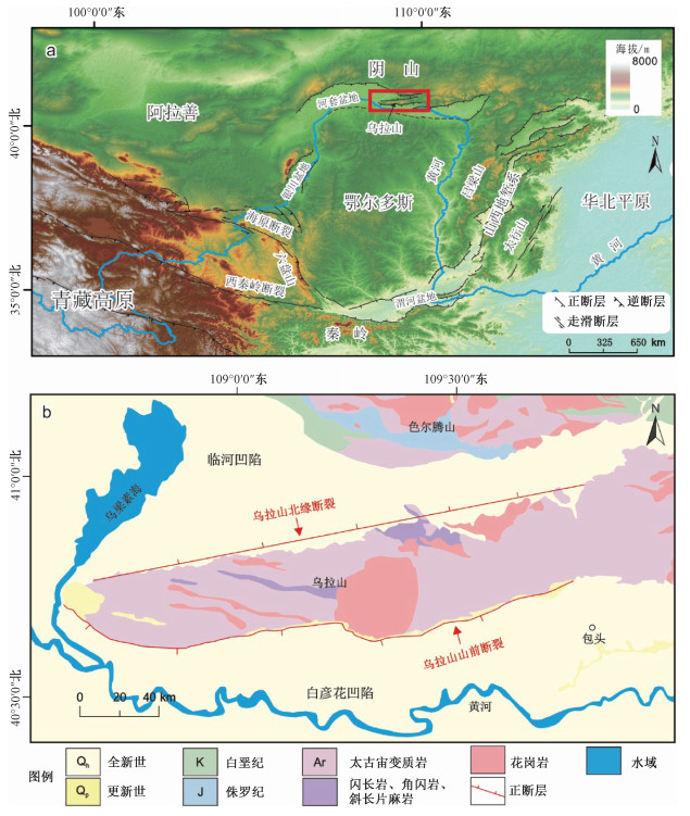
Figure 1.
Structural location and geological map of the Wulashan horst
-
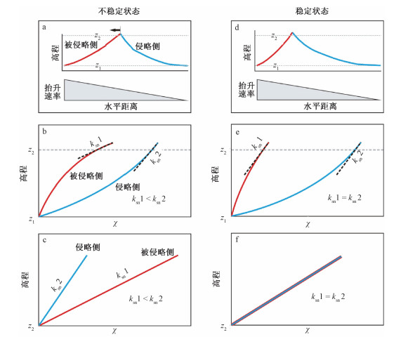
Figure 2.
Schematic diagram showing the elevation- χ profiles of the divide both in unsteady and steady states (modified from Zhou et al., 2022b)
-
Figure 3.
The χ value distribution of river channels with different elevations
-
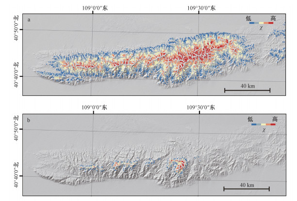
Figure 4.
The distribution of river channels on both sides of the main drainage divide of the Wulashan horst
-
Figure 5.
Distribution map of river elevation- χ values on both sides of the main drainage divide of the Wulashan horst(The distribution of the river channels is shown in Fig. 4)
-
Figure 6.
The undulation difference within 300 m on both sides of the main drainage divide of the Wulashan horst