
| China Geological Survey Chinese Academy of Geological Sciences | Host |
| 科学出版社 | Publish |

| Citation: |
TAO Changxu, ZHANG Yongshuang, REN Sanshao. 2025. Research progress of InSAR technology application on landslide identification and monitoring[J]. Geology in China, 52(2): 513-526. doi: 10.12029/gc20240515001

|
Research progress of InSAR technology application on landslide identification and monitoring
-
Abstract
This paper is the result of geological survey engineering.
Objective Landslides pose a significant risk to major constructions and human safety in mountainous areas, and the early identification and monitoring of landslide has become an important way to prevent risk.
Methods This paper briefly introduces the basic principle of InSAR technology and its development history, and introduces the current research status of its application in landslide identification and monitoring.
Results The three types of landslide InSAR identification are regional, key sections and single landslide. InSAR monitoring of landslides mainly focuses on large landslides with significant risk, and highlights the research progress in monitoring method and early warning modeling. On this basis, the main challenges faced by InSAR technology in landslide identification and monitoring research at this stage are pointed out, including: the challenge of geometrical distortion in side−view imaging under complex terrain conditions, detecting large gradient deformation of landslides, atmospheric delays and vegetation penetration, etc. InSAR technology in landslide application still exists problems such as insufficient capacity of large−scale monitoring, low degree of automation of processing process, and insufficient degree of data analysis and mining.
Conclusions The future development direction of InSAR technology in landslide identification and monitoring is prospected. With the continuous improvement of the application level of InSAR technology, it will effectively promote the new leap in landslide disaster risk prevention.
-

-
References
[1] Askne J I H, Dammert P B G, Ulander L M H, Smith G. 1997. C–band repeat–pass interferometric SAR observations of the forest[J]. IEEE Transactions on Geoscience and Remote Sensing, 35(1): 25−35. doi: 10.1109/36.551931 [2] Aslan G, Foumelis M, Raucoules D, De M M, Bernardie S, Cakir Z. 2020. Landslide mapping and monitoring using persistent scatterer interferometry (PSI) technique in the French Alps[J]. Remote Sensing, 12: 1305. doi: 10.3390/rs12081305 [3] Bamler R, Eineder M. 2005. Accuracy of differential shift estimation by correlation and split–bandwidth interferometry for wideband and delta–k SAR systems[J]. IEEE Geoscience and Remote Sensing Letters, 2(2): 151−155. doi: 10.1109/LGRS.2004.843203 [4] Bamler R, Hartl P. 1998. Synthetic aperture radar interferometry[J]. Inverse Problems, 14(4): R1−R54. doi: 10.1088/0266-5611/14/4/001 [5] Bao M Q, Bruning C, Alpers W. 1997. Simulation of ocean waves imaging by an along–track interferometric synthetic aperture radar[J]. IEEE Transactions on Geoscience and Remote Sensing, 35(3): 618−631. doi: 10.1109/36.581977 [6] Berardino P, Fornaro G, Lanari R, Sansosti E. 2002. A new algorithm for surface deformation monitoring based on small baseline differential SAR interferograms[J]. IEEE Transactions on Geoscience and Remote Sensing, 40(11): 2375−2383. doi: 10.1109/TGRS.2002.803792 [7] Carla T, Intrieri E, Raspini F, Bardi F, Casagli N. 2019. Perspectives on the prediction of catastrophic slope failures from satellite InSAR[J]. Scientific Reports, 9: 14137. doi: 10.1038/s41598-019-50792-y [8] Casagli N, Intrieri E, Tofani V, Gigli G, Raspini F. 2023. Landslide detection, monitoring and prediction with remote–sensing techniques[J]. Nature Reviews Earth & Environment, 4(1): 51−64. [9] Dai K R, Li Z H, Xu Q, Burgmann R, Milledge D G, Tomas R, Fan X M, Zhao C Y, Liu X J, Peng J B, Zhang Q, Wang Z, Qu T T, He C Y, Li D R, Liu J N. 2020. Entering the era of earth observation–based landslide warning systems: A novel and exciting framework[J]. IEEE Geoscience and Remote Sensing Magazine, 8(1): 136−153. doi: 10.1109/MGRS.2019.2954395 [10] Dehghani M. 2016. Landslide monitoring using hybrid conventional and persistent scatterer interferometry[J]. Journal of the Indian Society of Remote Sensing, 44(4): 505−513. doi: 10.1007/s12524-015-0536-3 [11] Delacourt C, Allemand P, Berthier E, Raucoules D, Casson B, Grandjean P, Pambrun C, Varel E. 2007. Remote–sensing techniques for analysing landslide kinematics: A review[J]. Bulletin De La Societe Geologique De France, 178(2): 89−100. doi: 10.2113/gssgfbull.178.2.89 [12] Ferretti A, Fumagalli A, Novali F, Prati C, Rocca F, Rucci A. 2011. A new algorithm for processing interferometric Data–Stacks: SqueeSAR[J]. IEEE Transactions on Geoscience and Remote Sensing, 49(9): 3460−3470. doi: 10.1109/TGRS.2011.2124465 [13] Ferretti A, Prati C, Rocca F. 2001. Permanent scatterers in SAR interferometry[J]. IEEE Transactions on Geoscience and Remote Sensing, 39(1): 8−20. doi: 10.1109/36.898661 [14] Galloway D L, Hudnut K W, Ingebritsen S E, Phillips S P, Peltzer G, Rogez F, Rosen P A. 1998. Detection of aquifer system compaction and land subsidence using interferometric synthetic aperture radar, Antelope Valley, Mojave Desert, California[J]. Water Resources Research, 34(10): 2573−2585. doi: 10.1029/98WR01285 [15] Gao H Y, Gao Y, Li B, Yin Y P, Yang C S, Wan J W, Zhang T T. 2023. The dynamic simulation and potential hazards analysis of the Yigong landslide in Xizang, China[J]. Remote Sensing, 15(5): 19. [16] Ge Daqing, Wang Yan, Fan Jinghui, Liu Shengwei, Guo Xiaofang, Wang Yi. 2007. A study of surface deformation monitoring using differential SAR interferometry technique and an analysis of its key problems[J]. Remote Sensing for Land and Resources, (4): 14−22 (in Chinese with English abstract). [17] Gong Jianya, Li Yansheng. 2022. Can quantitative remote sensing and machine learning be integrated?[J]. Earth Sciences, 47(10): 3911−3912 (in Chinese). [18] Herrera G, Gutiérrez F, García–Davalillo J C, Guerrero J, Notti D, Galve J P, Fernández–Merodo J A, Cooksley G. 2013. Multi–sensor advanced DInSAR monitoring of very slow landslides: The Tena Valley case study (Central Spanish Pyrenees)[J]. Remote Sensing of Environment, 128: 31−43. doi: 10.1016/j.rse.2012.09.020 [19] Hilley G E, Bürgmann R, Ferretti A, Novali F, Rocca F. 2004. Dynamics of slow–moving landslides from permanent scatterer analysis[J]. Science, 304(5679): 1952−1955. doi: 10.1126/science.1098821 [20] Hooper A, Zebker H, Segall P, Kampes B. 2004. A new method for measuring deformation on volcanoes and other natural terrains using InSAR persistent scatterers[J]. Geophysical Research Letters, 31: L23611. [21] Hrysiewicz A Wang X, Holohan E P. 2023. EZ–InSAR: An easy–to–use open–source toolbox for mapping ground surface deformation using satellite interferometric synthetic aperture radar[J]. Earth Science Informatics, 16(2): 1929−1945. doi: 10.1007/s12145-023-00973-1 [22] Hu J, Li Z W, Ding X L, Zhu J J, Sun Q. 2013. Derivation of 3–D coseismic surface displacement fields for the 2011 MS 9.0 Tohoku–Oki earthquake from InSAR and GPS measurements[J]. Geophysical Journal International, 192(2): 573−585. doi: 10.1093/gji/ggs033 [23] Huang H B, Ju S J, Duan W, Jiang D J, Gao Z L, Liu H. 2023. Landslide monitoring along the Dadu River in Sichuan based on Sentinel–1 Multi–Temporal InSAR[J]. Sensors, 23(7): 16. [24] Jung H S, Won J S, Kim S W. 2009. An improvement of the performance of Multiple–Aperture SAR interferometry (MAI)[J]. IEEE Transactions on Geoscience and Remote Sensing, 47(8): 2859−2869. doi: 10.1109/TGRS.2009.2016554 [25] Klees R, Massonnet D. 1998. Deformation measurements using SAR interferometry: Potential and limitations[J]. Geologie En Mijnbouw, 77: 161−176. doi: 10.1023/A:1003594502801 [26] Li Deren, Zhou Yueqing, Ma Hongchao. 2000. Principles and applications of interferometry SAR[J]. Developments in Surveying and Mapping, 25(1): 9−12 (in Chinese with English abstract). [27] Li Jun. 2022. Design and Implementation of Visualization and Monitoring and Early Warning Platform Integrating Multi–source Deformation Data[D]. Changsha: Central South University, 1–75 (in Chinese with English abstract). [28] Li Menghua, Zhang Lu, Dong Jie, Cai Jiehua, Liao Mingsheng. 2021. Detection and monitoring of potential landslides along Minjiang River valley in Maoxian County, Sichuan using radar remote sensing[J]. Geomatics and Information Science of Wuhan University, 46(10): 1529−1537 (in Chinese with English abstract). [29] Li Tianbin, Chen Mingdong. 1996. Time prediction of landslide using Verhulst inverse– function model[J]. Journal of Geological Hazards and Environment Preservation, 7(3): 13−17, 29 (in Chinese with English abstract). [30] Li Xiaoen, Zhou Liang, Su Fenzhen, Wu Wenzhou. 2021. Application of InSAR technology in landslide hazard: Progress and prospects[J]. National Remote Sensing Bulletin, 25(2): 614−629 (in Chinese with English abstract). doi: 10.11834/jrs.20209297 [31] Li Zhenhong, Song Chuang, Yu Chen, Xiao Ruya, Chen Lifu, Luo Hui, Dai Keren, Ge Daqing, Ding Yi, Zhang Yuxing, Zhang Qin. 2019. Application of satellite radar remote sensing to landslide detection and monitoring: Challenges and solutions[J]. Geomatics and Information Science of Wuhan University, 44(7): 967−979 (in Chinese with English abstract). [32] Li Zhenhong, Zhu Wu, Yu Chen, Zhang Qin, Zhang Chenglong, Liu Zhenjiang, Zhang Xuesong, Chen Bo, Du Jiantao, Song Chuang, Han Bingquan, Zhou Jiawei. 2022. Interferometric synthetic aperture radar for deformation mapping: Opportunities, challenges and the outlook[J]. Acta Geodaetica et Cartographica Sinica, 51(7): 1485−1519 (in Chinese with English abstract). [33] Li Zhenhong, Zhu Wu, Yu Chen, Zhang Qin, Yang Yuanxi. 2023. Development status and trends of imaging geodesy[J]. Acta Geodaetica et Cartographica Sinica, 52(11): 1805−1834 (in Chinese with English abstract). [34] Liu Bin, Ge Daqing, Wang Shanshan, Li Man, Zhang Ling, Wang Yan, Wu Qiong. 2020. Combining application of TOPS and ScanSAR InSAR in large–scale geohazards identification[J]. Geomatics and Information Science of Wuhan University, 45(11): 1756−1762 (in Chinese with English abstract). [35] Liu Bin, Zhang Li, Ge Daqing, Li Man, Zhou Xiaolong, Guo Zhaocheng, Shi Pengqing, Zhang Ling, Jin Dingjian, Wan Xiangxing, Wang Yu, Wang Yan. 2024. Application of InSAR monitoring large deformation of landslides using Lutan–1 constellation[J]. Geomatics and Information Science of Wuhan University, 49(10): 1753−1762 (in Chinese with English abstract). [36] Liu Guoxiang, Chen Qiang, Luo Xiaojun, Cai Guolin. 2019. InSAR Principles and Applications[M]. Beijing: Science Press (in Chinese). [37] Liu W C, Zhang Y, Liang Y W, Sun P P, Li Y X, Su X J, Wang A J, Meng X M. 2022a. Landslide risk assessment using a combined approach based on InSAR and random forest[J]. Remote Sensing, 14: 2131. doi: 10.3390/rs14092131 [38] Liu Xiaojie. 2022. Research on Key Technologies for Early Identification, Monitoring and Forecasting of Wide–area Landslides with Spaceborne Radar Remote Sensing[D]. Xi’an: Chang'an University, 1–264 (in Chinese with English abstract). [39] Liu Xiaoyi, Zhang Yongshuang, Guo Changbao, Wu Rui'an Ren Sanshao, Shen Yanqi. 2019. Development characteristics and evolution process of the Garazong ancient rockslide along the Xianshuihe River in western Sichuan[J]. Acta Geologica Sinica, 93(7): 1767−1777 (in Chinese with English abstract). [40] Liu Xinghong, Yao Xin, Yu Kaibing, Dai Fuchu, Wang Shifeng, Yao Jiaming. 2020. Remote sensing integrated identification of geological hazards in the Batang—Mangkang section of the Sichuan—Xizang Highway[J]. Advanced Engineering Sciences, 52(6): 49−60 (in Chinese with English abstract). [41] Liu X J, Zhao C Y, Zhang Q, Lu Z, Li Z H. 2020. Deformation of the Baige landslide, Xizang, China, revealed through the integration of Cross−Platform ALOS/PALSAR−1 and ALOS/PALSAR−2 SAR observations[J]. Geophysical Research Letters, 47: 2019GL086142. doi: 10.1029/2019GL086142 [42] Liu X Y, Zhang Y S, Ren S S, Tong L Q, Guo Z C. 2023. A comprehensive remote sensing identification model for ancient landslides in the Dadu river basin on the eastern margin of Xizang plateau[J]. Frontiers in Earth Science, 11: 1268826. doi: 10.3389/feart.2023.1268826 [43] Liu Y F, Yang H L, Wang S Z, Xu L L, Peng J H. 2022b. Monitoring and stability analysis of the deformation in the Woda landslide area in Xizang, China by the DS–InSAR method[J]. Remote Sensing, 14: 532. doi: 10.3390/rs14030532 [44] Mattar K E, Vachon P W, Geudtner D, Gray A L, Cumming I G, Brugman M. 1998. Validation of Alpine glacier velocity measurements using ERS tandem–mission SAR data[J]. IEEE Transactions on Geoscience and Remote Sensing, 36(3): 974−984. doi: 10.1109/36.673688 [45] Metternicht G, Hurni L, Gogu R. 2005. Remote sensing of landslides: An analysis of the potential contribution to geo–spatial systems for hazard assessment in mountainous environments[J]. Remote Sensing of Environment, 98(2/3): 284−303. [46] Moreira A, Prats–Iraola P, Younis M, Krieger G, Hajnsek I, Papathanassiou K P. 2013. A tutorial on synthetic aperture radar[J]. IEEE Geoscience and Remote Sensing Magazine, 1(1): 6−43. doi: 10.1109/MGRS.2013.2248301 [47] Peng Jianbing, Li Zhenhong. 2022. Can geologic big data help in geohazard forecasting?[J]. Earth Science, 47(10): 3900−3901 (in Chinese). [48] Price E J, Sandwell D T. 1998. Small–scale deformations associated with the 1992 Landers, California, earthquake mapped by synthetic aperture radar interferometry phase gradients[J]. Journal of Geophysical Research: Solid Earth, 103(B11): 27001−27016. doi: 10.1029/98JB01821 [49] Qi Xing, Zhu Xing, Xu Qiang, Zhao Kuanyao, Huo Dongdong, Wang Hao, Xiu Dehao. 2020. Improvement and application of landslide proximity time prediction method based on Saito model[J]. Journal of Engineering Geology, 28(4): 832−839 (in Chinese with English abstract). [50] Ran Tao, Xu Ruge, Zhou Hongfu, Zhang Jinghua, Chen Hao, Wang Yuke, Sun Jie, Cui Yanzong. 2024. Type, formation mechanism and distribution regularity of landslides in the deeply incised valley area of Yalong River Basin—A case study of Zituoxi–Malangcuo river section[J]. Geology in China, 51(2): 511−524 (in Chinese with English abstract). [51] Reyes–Carmona C, Barra A, Pedro G J, Monserrat O, Vicente P J, Maria M R, Notti D, Ruano P, Millares A, Lopez–Vinielles J, Miguel A J. 2020. Sentinel–1 D–InSAR for monitoring active landslides in critical infrastructures: The case of the rules reservoir (Southern Spain)[J]. Remote Sensing, 12(5): 809. doi: 10.3390/rs12050809 [52] Rodriguez E, Martin J M 1992. Theory and design of interferometric synthetic aperture radars[J]. IEE Proceedings–F Radar and Signal Processing, 139(2): 147–159. [53] Saito M. 1969. Forecasting time of slope failure by tertiary creep[C]//Proceedings of the 7th International Conference on Soil Mechanics and Foundation Engineering Mexico City, (2): 677–683. [54] Samsonov S, Dille A, Dewitte O, Kervyn F, d'Oreye N. 2020. Satellite interferometry for mapping surface deformation time series in one, two and three dimensions: A new method illustrated on a slow–moving landslide[J]. Engineering Geology, 266: 105471. doi: 10.1016/j.enggeo.2019.105471 [55] Scheingross J S, Minchew B M, Mackey B H, Simons M, Lamb M P, Hensley S. 2013. Fault–zone controls on the spatial distribution of slow–moving landslides[J]. Geological Society of America Bulletin, 125(3/4): 473−489. [56] Segalini A, Valletta A, Carri A. 2018. Landslide time–of–failure forecast and alert threshold assessment: A generalized criterion[J]. Engineering Geology, 245: 72−80. doi: 10.1016/j.enggeo.2018.08.003 [57] Shan Y F, Xu Z, Zhou S S, Lu H Y, Yu W L, Li Z G, Cao X, Li P F, Li W L. 2024. Landslide hazard assessment combined with InSAR deformation: A case study in the Zagunao River Basin, Sichuan Province, Southwestern China[J]. Remote Sensing, 16: 99. [58] Sica F, Calvanese F, Scarpa G, Rizzoli P. 2022. A CNN–based coherence–driven approach for InSAR phase unwrapping[J]. IEEE Geoscience and Remote Sensing Letters, 19: 4003705. [59] Small D, Pasquali P, Holecz F, Meier E, Nuesch D. 1998. Experiences with multiresolution and multifrequency InSAR height model generation[C]//International Geoscience and Remote Sensing Symposium (IGARSS 98) on Sensing and Managing the Environment. Seattle. 1998: 2671–2673. [60] Su Xiaojun, Zhang Yi, Jia Jun, Liang Yiwen. 2021. InSAR–based monitoring and identification of potential landslides in Lueyang County, the Southern Qinling Mountains, China[J]. Mountain Research, 39(1): 59−70 (in Chinese with English abstract). [61] Tomás R, Díaz E, Szeibert W T, Liu X, Lopez–Sanchez J M, Zhao C. 2023. Geomorphological characterization, remote sensing monitoring, and modeling of a slow–moving landslide in Alcoy (Southern Spain)[J]. Landslides, 20(6): 1293−1301. doi: 10.1007/s10346-023-02032-8 [62] Wang B H, Zhao C Y, Zhang Q, Peng M M. 2019. Sequential InSAR time series deformation monitoring of land subsidence and rebound in Xi'an, China[J]. Remote Sensing, 11: 2845. doi: 10.3390/rs11232845 [63] Wang W D, Motagh M, Mirzaee S, Tao L, Zhou C, Tang H, Roessner S. 2023. The 21 July 2020 Shaziba landslide in China: Results from multi–source satellite remote sensing[J]. Remote Sensing of Environment, 295: 113669. doi: 10.1016/j.rse.2023.113669 [64] Wasowski J, Bovenga F. 2014. Investigating landslides and unstable slopes with satellite Multi Temporal Interferometry: Current issues and future perspectives[J]. Engineering Geology, 174: 103−138. doi: 10.1016/j.enggeo.2014.03.003 [65] Xiao R Y, Chen Y, Li Z H, Jiang M, He X F. 2022. InSAR stacking with atmospheric correction for rapid geohazard detection: Applications to ground subsidence and landslides in China[J]. International Journal of Applied Earth Observation and Geoinformation, 115(10): 103082. [66] Xu Qiang, Zeng Yuping, Qian Jiangpeng, Wang Chengjun, He Chengjiang. 2009. Study on an improved tangential angle and the corresponding landslide pre–warning criteria[J]. Geological Bulletin of China, 28(4): 501−505 (in Chinese with English abstract). [67] Xu Qiang, Dong Xiujun, Li Weile. 2019. Integrated space–air–ground early detection, monitoring and warning system for potential catastrophic geohazards[J]. Geomatics and Information Science of Wuhan University, 44(7): 957−966 (in Chinese with English abstract). [68] Xu Qiang, Cui Shenghua, Huang Wei, Pei Xiangjun, Fan Xuanmei, Ai Ying, Zhao Weihua, Luo Yonghong, Luo Jing, Liu Ming, Xia Min, Wang Fei, Peng Dalei, Zheng Guang, Chen Wanlin. 2023. Construction of a landslide knowledge graph in the field of engineering geology[J]. Geomatics and Information Science of Wuhan University, 48(10): 1601−1615 (in Chinese with English abstract). [69] Yan Yiqiu, Guo Changbao, Zhong Ning, Li Xue, Li Caihong. 2022. Deformation characteristics of Jiaju ancient landslide based on InSAR monitoring method, Sichuan, China[J]. Earth Science, 47(12): 4681−4697 (in Chinese with English abstract). [70] Yang Chao, Yang Yinghui, Wang Jiyan, Xu Qiang, Chen Qiang, Tao Xinxin, Hu Zhiqing. 2023. Inferring landslide depth based on ascending and descending InSAR deformations–example of Taoping village ancient landslide[J]. Journal of Engineering Geology, 31(3): 1−12 (in Chinese with English abstract). [71] Yao Xin, Zhang Yongshuang, Li Lingjing, Ling Sheng, Wang Zhongsheng, Zhou Zhenkai. 2017. InSAR–based recognition of slow–moving slop disasters along the Xianshuihe active fault in the Qinghai–Xizang Plateau[J]. Acta Geologica Sinica, 91(8): 1694−1705 (in Chinese with English abstract). [72] Yao Xin, Deng Jianhui, Liu Xinghong, Zhou Zhenkai, Yao Jiaming, Dai Fuchu, Ren Kaiyu, Li Lingjing. 2020. Primary recognition of active landslides and development rule analysis for Pan three–river–parallel territory of Xizang Plateau[J]. Advanced Engineering Sciences, 52(5): 16−37 (in Chinese with English abstract). [73] Ye Xia, Kaufmann H, Guo X F. 2004. Landslide monitoring in the Three Gorges area using D–InSAR and corner reflectors[J]. Photogrammetric Engineering and Remote Sensing, 70(10): 1167−1172. doi: 10.14358/PERS.70.10.1167 [74] Zhang Benhao, Wei Yunjie, Yang Chengsheng, Xiong Guohua, Dong Jihong. 2022. InSAR identification and monitoring of geological hazards in Ranwu region of Xizang[J]. The Chinese Journal of Geological Hazard and Control, 33(1): 18−26 (in Chinese with English abstract). [75] Zhang C L, Li Z H, Ding M T, Zhu W, Chen B, Zhuang J Q, Du J T, Peng J B. 2023a. Dynamic deformation monitoring and scenario simulation of the Xiaomojiu landslide in the Jinsha River Basin, China[J]. Landslides, 20: 2343−2358. doi: 10.1007/s10346-023-02103-w [76] Zhang Y S, Ren S S, Liu X Y, Guo C B, Li J Q, Bi J B, Ran LN. 2023b. Reactivation mechanism of old landslide triggered by coupling of fault creep and water infiltration: A case study from the east Xizang Plateau[J]. Bulletin of Engineering Geology and the Environment, 82: 291. doi: 10.1007/s10064-023-03290-5 [77] Zhang Y, Li Y X, Meng X M, Liu W C, Wang A J, Liang Y W, Su X J, Zeng R Q, Chen X. 2023c. Automatic mapping of potential landslides using satellite multitemporal interferometry[J]. Remote Sensing, 15(20): 29. [78] Zhang Yongshuang, Liu Xiaoyi, Yao Xin. 2020. InSAR–based method for early recognition of ancient landslide reactivation in Dadu River, China[J]. Journal of Hydraulic Engineering, 51(5): 545−555 (in Chinese with English abstract). [79] Zhang Yongshuang, Liu Xiaoyi, Wu Rui'an, Guo Changbao, Ren Shanshao. 2021. Cognization, characteristics, age and evolution of the ancient landslides along the deep–cut valleys on the eastern Xizang Plateau, China[J]. Earth Science Frontiers, 28(2): 94−105 (in Chinese with English abstract). [80] Zhao Chaoying, Liu Xiaojie, Zhang Qin, Peng Jianbing, Xu Qiang. 2019. Research on loess landslide identification, monitoring and failure mode with InSAR technique in Heifangtai, Gansu[J]. Geomatics and Information Science of Wuhan University, 44(7): 996−1007 (in Chinese with English abstract). [81] Zhao F M, Meng X M, Zhang Y, Chen G, Su X J, Yue D X. 2019. Landslide susceptibility mapping of Karakorum highway combined with the application of SBAS–InSAR technology[J]. Sensors, 19(12): 18. [82] Zhao G H, Lan H X, Yin H Y, Li L P, Alexander S, Sun W F, Tian C Y. 2024. Deformation, structure and potential hazard of a landslide based on InSAR in Banbar county, Xizang[J]. China Geology, 7(2): 203−221. doi: 10.31035/cg2023130 [83] Zhu Tongtong, Shi Xuguo, Zhou Chao, Jiang Houjun, Zhang Lu, Liao Mingsheng. 2021. Stability monitoring and analysis of the Shuping landslide in the Three Gorges area with Sentinel–1 I mages from 2016 to 2020[J]. Geomatics and Information Science of Wuhan University, 46(10): 1560−1568 (in Chinese with English abstract). [84] 葛大庆, 王艳, 范景辉, 刘圣伟, 郭小方, 王毅. 2007. 地表形变D–InSAR监测方法及关键问题分析[J]. 国土资源遥感, (4): 14−22. [85] 龚健雅, 李彦胜. 2022. 定量遥感与机器学习能够融合吗?[J]. 地球科学, 47(10): 3911−3912. [86] 李德仁, 周月琴, 马洪超. 2000. 卫星雷达干涉测量原理与应用[J]. 测绘科学, 25(1): 9−12,1. doi: 10.3771/j.issn.1009-2307.2000.01.003 [87] 李军. 2022. 融合多源变形数据的可视化与监测预警平台设计与实现[D]. 长沙: 中南大学, 1–75. [88] 李梦华, 张路, 董杰, 蔡杰华, 廖明生. 2021. 四川茂县岷江河谷区段滑坡隐患雷达遥感识别与形变监测[J]. 武汉大学学报(信息科学版), 46(10): 1529−1537. [89] 李天斌, 陈明东. 1996. 滑坡时间预报的费尔哈斯反函数模型法[J]. 地质灾害与环境保护, 7(3): 13−17,29. [90] 李晓恩, 周亮, 苏奋振, 吴文周. 2021. InSAR技术在滑坡灾害中的应用研究进展[J]. 遥感学报, 25(2): 614−629. [91] 李振洪, 宋闯, 余琛, 肖儒雅, 陈立福, 罗慧, 戴可人, 葛大庆, 丁一, 张宇星, 张勤. 2019. 卫星雷达遥感在滑坡灾害探测和监测中的应用: 挑战与对策[J]. 武汉大学学报(信息科学版), 44(7): 967−979. [92] 李振洪, 朱武, 余琛, 张勤, 张成龙, 刘振江, 张雪松, 陈博, 杜建涛, 宋闯, 韩炳权, 周佳薇. 2022. 雷达影像地表形变干涉测量的机遇、挑战与展望[J]. 测绘学报, 51(7): 1485−1519. doi: 10.11947/j.issn.1001-1595.2022.7.chxb202207031 [93] 李振洪, 朱武, 余琛, 张勤, 杨元喜. 2023. 影像大地测量学发展现状与趋势[J]. 测绘学报, 52(11): 1805−1834. doi: 10.11947/j.AGCS.2023.20230003 [94] 刘斌, 葛大庆, 王珊珊, 李曼, 张玲, 王艳, 吴琼. 2020. TOPS和ScanSAR模式InSAR在广域地灾隐患识别中的联合应用[J]. 武汉大学学报(信息科学版), 45(11): 1756−1762. [95] 刘斌, 张丽, 葛大庆, 李曼, 周小龙, 郭兆成, 石鹏卿, 张玲, 金鼎坚, 万祥星, 王宇, 王艳. 2024. 陆地探测一号卫星滑坡大变形InSAR监测应用[J]. 武汉大学学报(信息科学版), 49(10): 1753−1762. [96] 刘国祥, 陈强, 罗小军, 蔡国林. 2019. InSAR原理与应用[M]. 北京: 科学出版社. [97] 刘晓杰. 2022. 星载雷达遥感广域滑坡早期识别与监测预测关键技术研究[D]. 西安: 长安大学, 1–264. [98] 刘筱怡, 张永双, 郭长宝, 吴瑞安, 任三绍, 沈亚麒. 2019. 川西鲜水河呷拉宗古滑坡发育特征与形成演化过程[J]. 地质学报, 93(7): 1767−1777. doi: 10.3969/j.issn.0001-5717.2019.07.015 [99] 刘星洪, 姚鑫, 於开炳, 戴福初, 王世锋, 姚佳明. 2020. 川藏高速巴塘—芒康段地质灾害遥感综合早期识别研究[J]. 工程科学与技术, 52(6): 49−60. [100] 彭建兵, 李振洪. 2022. 地学大数据可否助力地质灾害预报?[J]. 地球科学, 47(10): 3900−3901. [101] 亓星, 朱星, 许强, 赵宽耀, 霍冬冬, 王浩, 修德皓. 2020. 基于斋藤模型的滑坡临滑时间预报方法改进及应用[J]. 工程地质学报, 28(4): 832−839. [102] 冉涛, 徐如阁, 周洪福, 张景华, 陈浩, 王羽珂, 孙洁, 崔炎宗. 2024. 雅砻江流域深切河谷区滑坡类型、成因及分布规律—以子拖西—麻郎错河段为例[J]. 中国地质, 51(2): 511−524. doi: 10.12029/gc20220329004 [103] 苏晓军, 张毅, 贾俊, 梁懿文, 李媛茜, 孟兴民. 2021. 基于InSAR技术的秦岭南部略阳县潜在滑坡灾害识别研究[J]. 山地学报, 39(1): 59−70. [104] 许强, 曾裕平, 钱江澎, 王承俊, 何成江. 2009. 一种改进的切线角及对应的滑坡预警判据[J]. 地质通报, 28(4): 501−505. doi: 10.3969/j.issn.1671-2552.2009.04.011 [105] 许强, 董秀军, 李为乐. 2019. 基于天–空–地一体化的重大地质灾害隐患早期识别与监测预警[J]. 武汉大学学报(信息科学版), 44(7): 957−966. [106] 许强, 崔圣华, 黄维, 裴向军, 范宣梅, 艾瑛, 赵伟华, 罗永红, 罗璟, 刘明, 夏敏, 王飞, 彭大雷, 郑光, 陈婉琳. 2023. 面向工程地质领域的滑坡知识图谱构建方法研究[J]. 武汉大学学报(信息科学版), 48(10): 1601−1615. [107] 闫怡秋, 郭长宝, 钟宁, 李雪, 李彩虹. 2022. 基于InSAR形变监测的四川甲居古滑坡变形特征[J]. 地球科学, 47(12): 4681−4697. [108] 杨超, 杨莹辉, 王继燕, 许强, 陈强, 陶鑫鑫, 胡植庆. 2023. 利用InSAR升降轨形变数据反演滑坡深度—以桃坪乡古滑坡为例[J]. 工程地质学报, 31(3): 868−879. [109] 姚鑫, 张永双, 李凌婧, 凌盛, 王宗盛, 周振凯. 2017. 青藏高原鲜水河活动断裂带蠕变斜坡地质灾害InSAR识别研究[J]. 地质学报, 91(8): 1694−1705. doi: 10.3969/j.issn.0001-5717.2017.08.003 [110] 姚鑫, 邓建辉, 刘星洪, 周振凯, 姚佳明, 戴福初, 任开瑀, 李凌婧. 2020. 青藏高原泛三江并流区活动性滑坡InSAR初步识别与发育规律分析[J]. 工程科学与技术, 52(5): 16−37. [111] 张本浩, 魏云杰, 杨成生, 熊国华, 董继红. 2022. 西藏然乌地区地质灾害隐患点InSAR识别与监测[J]. 中国地质灾害与防治学报, 33(1): 18−26. [112] 张永双, 刘筱怡, 姚鑫. 2020. 基于InSAR技术的古滑坡复活早期识别方法研究—以大渡河流域为例[J]. 水利学报, 51(5): 545−555. [113] 张永双, 刘筱怡, 吴瑞安, 郭长宝, 任三绍. 2021. 青藏高原东缘深切河谷区古滑坡: 判识、特征、时代与演化[J]. 地学前缘, 28(2): 94−105. [114] 赵超英, 刘晓杰, 张勤, 彭建兵, 许强. 2019. 甘肃黑方台黄土滑坡InSAR识别、监测与失稳模式研究[J]. 武汉大学学报(信息科学版), 44(7): 996−1007. [115] 朱同同, 史绪国, 周超, 蒋厚军, 张路, 廖明生. 2021. 利用2016—2020年Sentinel–1数据监测与分析三峡库区树坪滑坡稳定性[J]. 武汉大学学报(信息科学版), 46(10): 1560−1568. -
Access History
Figures(2)
Tables(4)

Export File
Citation
TAO Changxu, ZHANG Yongshuang, REN Sanshao. 2025. Research progress of InSAR technology application on landslide identification and monitoring[J]. Geology in China, 52(2): 513-526. doi: 10.12029/gc20240515001
Format
Content
 DownLoad:
-
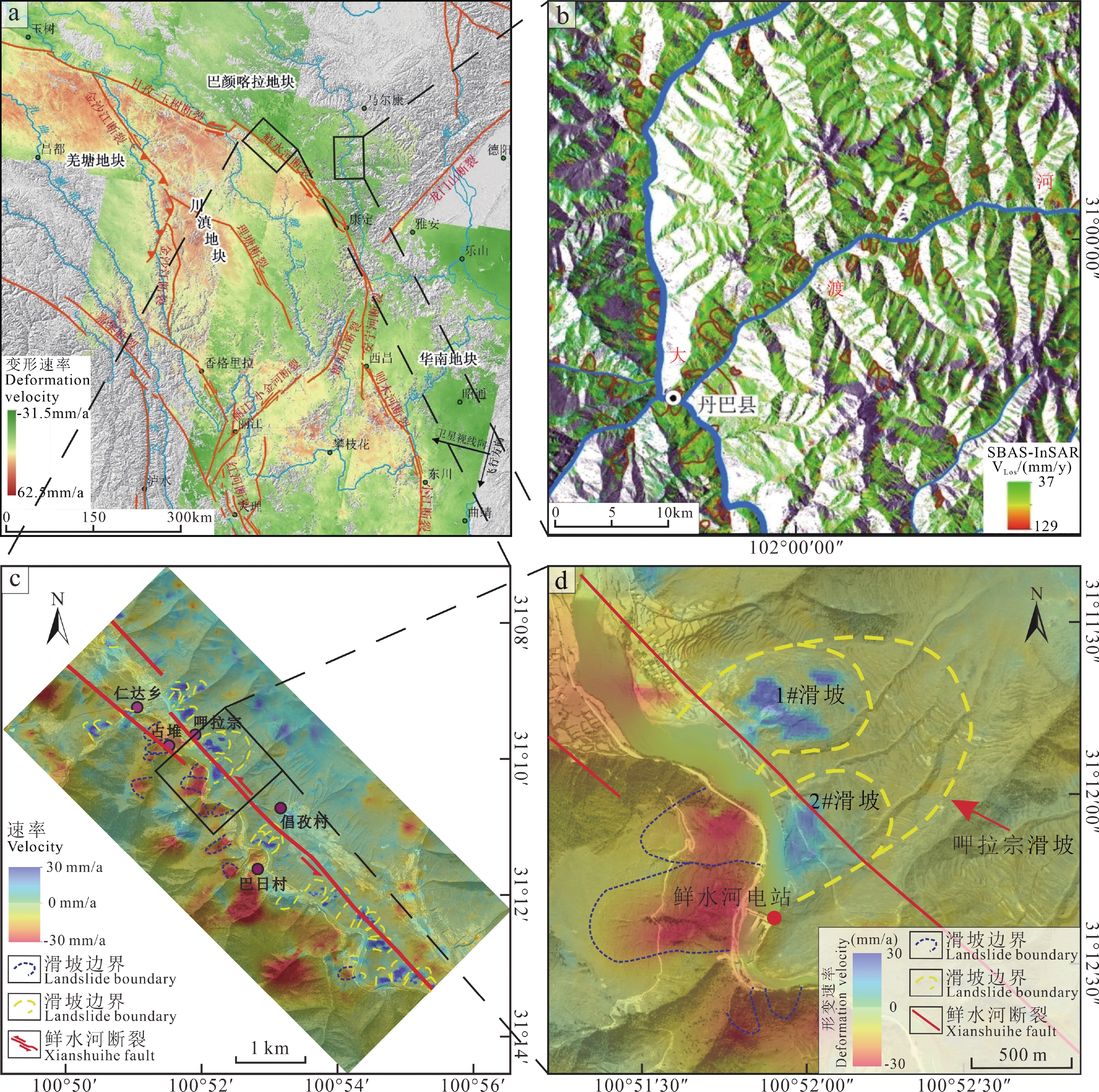
Figure 1.
InSAR landslide hazard identification (modified from Liu Xiaoyi et al., 2019)
-
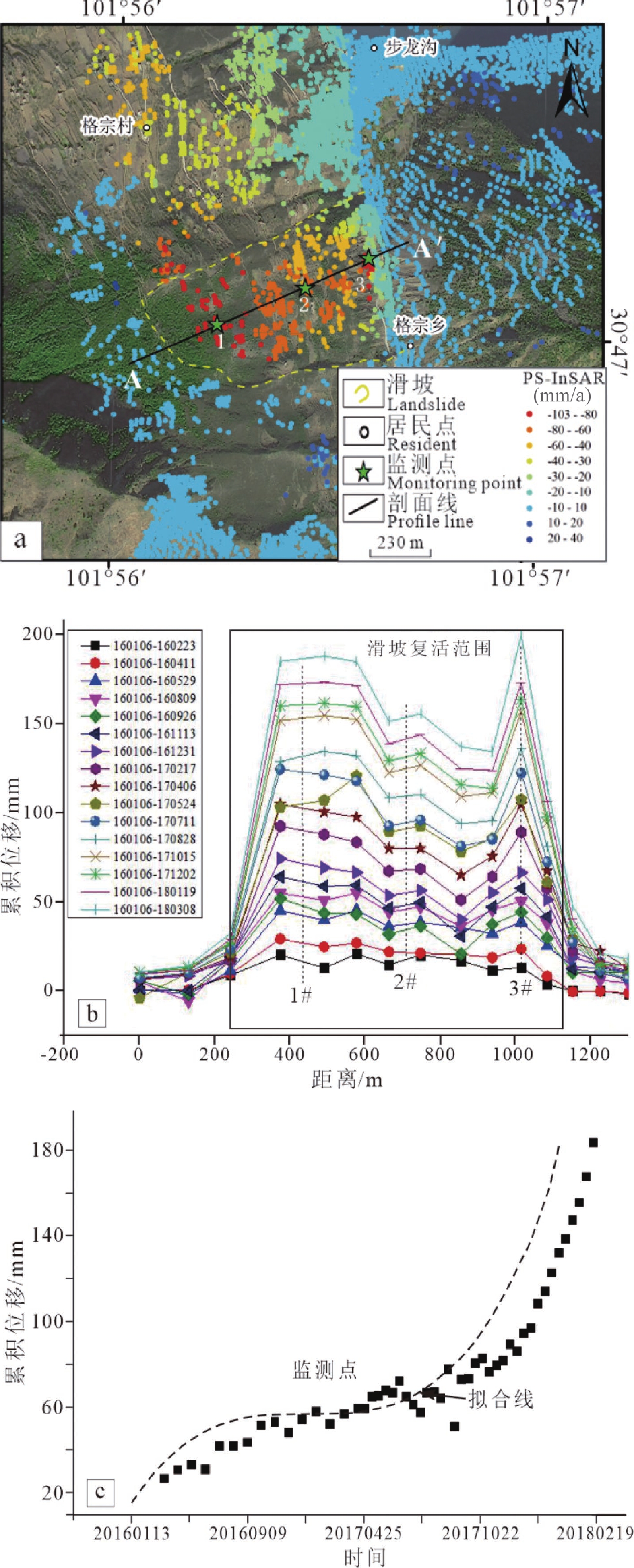
Figure 2.
Landslide monitoring curve based on InSAR technology (after Zhang Yongshuang et al., 2020)