
| China Geological Survey Chinese Academy of Geological Sciences | Host |
| 科学出版社 | Publish |

| Citation: |
ZHANG Jinghua, OUYANG Yuan, CHEN Yuanzhi, LI Fu, LIU Xiaoxia, LIU Hong, ZHAO Yinbing. 2021. Land suitability evaluation of agricultural industrial park based on UAV remote sensing in Zhaojue County of Sichuan Province[J]. Geology in China, 48(6): 1710-1719. doi: 10.12029/gc20210604

|
Land suitability evaluation of agricultural industrial park based on UAV remote sensing in Zhaojue County of Sichuan Province
-
Abstract
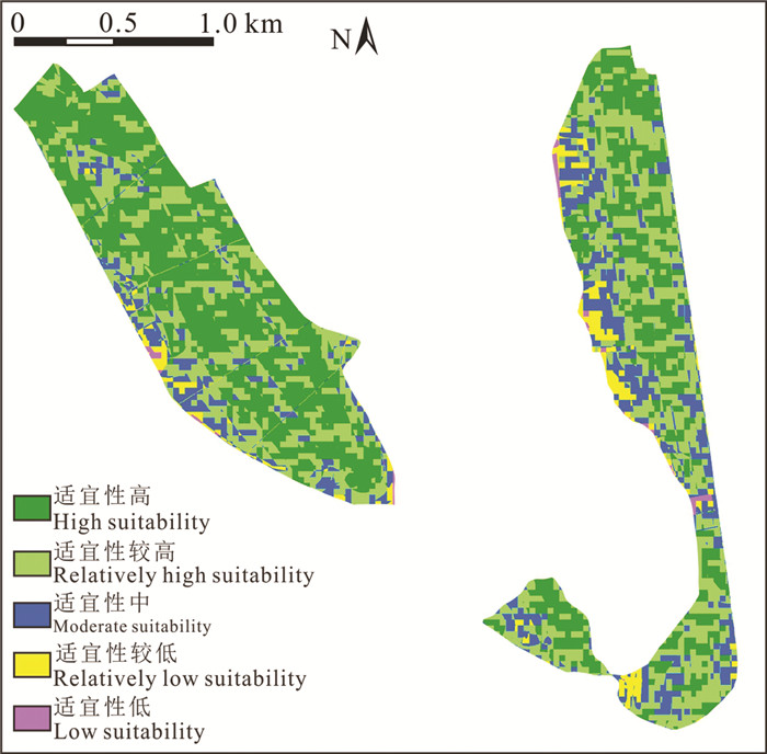
Zhaojue County is a typical Yi-inhabited County in the hinterland of Daliang Mountain. It is also a state-level deeply impoverished county with traditional agriculture as the main living means. In order to promote the transformation of agricultural development mode, modern agricultural park has been constructed in Zhaojue County. Through Unmanned Aerial Vehicle(UAV) aerial survey, the high-resolution images of the proposed park were obtained, and object-oriented image analysis software was used to quickly extract land use status and other information. Combined with other collected data, eight evaluation factors were selected, including slope, aspect, fault, geological hazard, land use, irrigation, transportation and nature reserve. With the support of Geographic Information System (GIS), the single-factor of land adaptability was evaluated first, and then the comprehensive evaluation was conducted. The results show that the land suitability of the proposed park is much suitable, with the total area of 2.56 km2, accounting for 79.26%, more than 3/4. It is suitable for building a modern agricultural industrial park, standardized vegetable greenhouses, and open field vegetable cultivation base. After construction, it will not only provide vegetable supply to the surrounding cities, but also increase the income of farmers around the park, and promote the poverty alleviation of farmers around the park, showing good development prospects. Small UAV remote sensing system has the advantages of flexibility and low cost. It can quickly obtain the basic data of small area and large-scale agricultural industrial park, and has ideal application effect in land suitability evaluation of small areas in Southwest China. The natural environment and social environment of small area land are relatively single, and many large regional land suitability evaluation indexes are not fully applicable, so it is necessary to select appropriate evaluation indexes according to the main purpose of land use.
-

-
References
Benz U C, Hofmann P, Willhauck G, Lingenfelder I, Heynen M. 2003. Multi-resolution, object-oriented fuzzy analysis of remote sensing data for GIS-ready information[J]. Journal of Photogrammetry & Remote Sensing, 58: 239-258. Bi Kai, Li Yingcheng, Ding Xiaobo, Liu Fei. 2014. Aerial photogrammetric technology of light small UAV: Status and trend of development[J]. Bulletin of Surveying and Mapping, (3): 27-31(in Chinese with English abstract). Chen Yanfei, Du Pengfei, Zheng Xiaojin, Lin Jin. 2006. Evaluation on ecological applicability of land construction in Nanning City based on GIS[J]. Journal of Tsinghua University(Science and Technology), 46(6): 801-804(in Chinese with English abstract). Cui Yong, Liu Zhiwei. 2014. A GIS-based approach for suitability evaluation of high standard primary farmland consolidation: A case from Huairou in Beijing[J]. China Land Sciences, 28(9): 76-81, 94-95(in Chinese with English abstract). Chen Pengfei, Hu Haifeng, Lian Xugang, Du Yongjun. 2017. On influence of post-processed difference technique and image control point density on UAV photogrammetry accuracy[J]. Bulletin of Surveying and Mapping, (11): 144-147(in Chinese with English abstract). Chen Qiaoyi. 2019. Application of UAV aerial survey technology in suitability analysis of construction[J]. Beijing Surveying and Mapping, 33(8): 995-968(in Chinese with English abstract). Fan Chengxiao, Han Jun, Xiong Zhijun, Zhao Yi. 2009. Application and status of unmanned aerial vehicle remote sensing technology[J]. Science of Surveying and Mapping, 34(5): 214-215(in Chinese with English abstract). Guan Xiaoke, Zhang Fengrong, Guo Lina, Zhao Tingting. 2010. A suitability evaluation of cultivated land in Beijing for multi-purposes use and its spatio-temporal investigation[J]. Resources Science, 32(3): 580-587(in Chinese with English abstract). He Shaolin, Xu Jinghua, Zhang Shuaiyi. 2013. Land use classification of object-oriented multi-scale by UAV image[J]. Remote Sensing for Land and Resources, 25(2): 107-112(in Chinese with English abstract). Hu Yong, Zhang Xiaocheng, Ma Zezhong, Zhou Zhiyue. 2016. Rural residential area extraction from UAV remote sensing imagery[J]. Remote Sensing for Land and Resources, 28(3): 96-101(in Chinese with English abstract). Jin Dingjian, Wang Jianchao, Wu Fang, Gao Zihong, Han Yachao, Li Qi. 2019. Aerial remote sensing technology and its applications in geological survey[J]. Remote Sensing for Land & Resources, 31(4): 1-10(in Chinese with English abstract). Li Min, Cui Shiyong, Li Chengming, Yin Jie, Li Yunlin. 2008. Object oriented information extraction from high resolution remote sensing Imagery——Taking the extraction of farmland for an example[J]. Remote Sensing Information, (6): 63-66, 89(in Chinese with English abstract). Lu Heng, Li Yongshy, Lin Xiancheng. 2011. Classification of high resolution imagery by unmanned aerial vehicle[J]. Science of Surveying and Mapping, 36(6): 106-108(in Chinese with English abstract). Li Deren, Li Ming. 2014. Research advance and application prospect of unmanned aerial vehicle remote sensing systems[J]. Geomatics and Information Science of Wuhan University, 39(5): 505-513, 540(in Chinese with English abstract). Li Fangting, Min Tian, Yao Zhiqing. 2017. Precision effect about triangulation based on unmanned aerial vehicle photogrammetry[J]. Bulletin of Surveying and Mapping, (S1): 75-78(in Chinese with English abstract). Li Wanneng, Tang Qingzhong, Chen Li. 2017. The effect on control point number of UAV to the calculation accuracy of aerial triangulation[J]. Bulletin of Surveying and Mapping, (S1): 84-89(in Chinese with English abstract). Liang Linlin, Jiang Liming, Zhou Zhiwei, Chen Yuxing, Sun Yafei. 2019. Object-oriented classification of unmanned aerial vehicle image for thermal erosion gully boundary extraction[J]. Remote Sensing for Land & Resources, 31(2): 180-186(in Chinese with English abstract). Liu Hong, Huang Hanxiao, Ouyang Yuan, Zhang Jinghua, Zhang Tengjiao, Li Fu, Xiao Qiliang, Zeng Jian, Hou Qian, Wen Dengkui, Duan Shengyi. 2020. Soil's geologic investigation in Daliangshan, Xichang, Sichuan[J]. Sedimentary Geology and Tethyan Geology, 40(1): 91-105(in Chinese with English abstract). Lou Peiqing, Chen Xiaoyu, Wang Shutong, Fu Bolin, Huang Yongyi, Tang Tingyuan, Ling Ming. 2020. Object recognition of karst farming area based on UAV image: A case study of Guilin[J]. Remote Sensing for Land & Resources, 32(1): 216-223(in Chinese with English abstract). Lu Li, Wang Zhe, Zou Shengzhang, Fan Lianjie, Lin Yongsheng, Zhou Changsong. 2021. Analysis of geothermal temperature and genetic model in Zhaojue County of Sichuan Province[J]. Geological Bulletin of China, 40(2/3): 434-441(in Chinese with English abstract). Mai Xiaozheng, Yang Bo, Feng Xiaoming. 2012. Research on the method of Layout of unmanned aerial vehicle[J]. Bulletin of Surveying and Mapping, (S1): 268-271(in Chinese). Ma L, Cheng L, Han W Q, Zhong L S, Li M C. 2014. Cultivated land information extraction from high-resolution unmanned aerial vehicle imagery data[J]. Journal of Applied Remote Sensing, 8(1): 083673. doi: 10.1117/1.JRS.8.083673 Qu Yanbo, Zhang Fengrong, Jiang Guanghui, Guan Xiaoke, Guo Lina. 2010. Suitability evaluation and subarea control and regulation of rural residential land based on niche[J]. Transactions of the CSAE, 26(11): 290-296(in Chinese with English abstract). Shi Tongguang, Zheng Guoqiang, Wang Zhiyong, Wang Linlin. 2007. Progress in research on land suitability evaluation in China[J]. Progress in Geography, 26(2): 106-115(in Chinese with English abstract). Sun Yi. 2014. Unmanned Aircraft Systems Pilot Aviation Handbook[M]. Beijing: China Civil Aviation Publishing House, 123-127. Sun Changkui, Liu Shanlei, Wang Shengyao, Chen Chao, Shen Quanfei, Shi Shanqiu, Wang Wei. 2018. Application of UAV in construction of smart city[J]. Remote Sensing for Land & Resources, 30(4): 8-12(in Chinese with English abstract). Wang Wenyu, Li Bo. 2006. Auto-identify classification technology adopted to high-resolution remote sensing image bye Cognition software[J]. Journal of Beijing Institute of Civil Engineering and Architecture, 22(4): 26-29(in Chinese with English abstract). Watts A C, Ambrosia V G, Hinkley E A. 2012. Unmanned aircraft systems in remote sensing and scientific research: classification and considerations of use[J]. Remote Sensing, (4): 1671-1692. Wu Cifang, Ye Yanmei, Wu Yuzhe, Yue Wenze. 2019. Land and Space Plan[M]. Beijing: Geological Publishing House, 199-204(in Chinese). Wang Junhao, Wei Yunjie, Mei Aoshuang, Guan Jianjun, Ding Xiang, Wang Shuangting. 2021. Multidimensional extraction of UAV tilt photography-based information of loess landslide and its application[J]. Geology in China, 48(2): 388-401(in Chinese with English abstract). Xinhuanet. com. 2018-02-12. Xi Jinping enters Liangshan, delivering 3 important messages[OL]. http://www.xinhuanet.com/politics/2018-02/12/c_1122410563.htm. Xiang Jie, Chen Jianping, Li Shi, Lai Zili, Huang Haozhong, Liu Jing, Xie Shuai. 2018. Research on application of unmanned aerial vehicle technology to dynamic monitoring of reserves in the Shouyun iron mine, Beijing[J]. Remote Sensing for Land & Resources, 30(3): 224-229(in Chinese with English abstract). Yu Fei, Zhang Yongwen, Wang Yu, Luo Kai, Chen Dabing, Xie Jian. 2021. Distribution characteristics and influencing factors ofgermanium-rich soil in typical agricultural area ofChongqing municipality[J]. Geology and Resources, 30(5): 609-616(in chinese with english abstract). Yu Q, Gong P, Clinton N, Biging G, Kelly M, Schirokauer D. 2006. Object-based detailed vegetation classification with airborne high spatial resolution remote sensing imagery[J]. Photogrammetric Engineering & Remote Sensing, 72(7): 799-811. Zhu Jin, Ding Yazhou, Chen Panjie, Wang Xin'an, Guo Bingxuan, Xiao Xiongwu, Niu Keke. 2016. Influence of control points' layout on aero-triangulation accuracy for UAV images[J]. Science of Surveying and Mapping, 41(5): 116-120(in Chinese with English abstract). Zhang Tengjiao, Liu Hong, Ouyang Yuan, Huang Hanxiao, Zhang Jinghua, Li Fu, Xiao Qiliang, Zeng Jian, Hou Qian, Wen Dengkui, Duan Shengyi. 2020. A preliminary discussion on the physical and chemical characteristics and main controlling factors of soil and parent material in the middle and high mountain area——Take Xichang as an example[J]. Sedimentary Geology and Tethyan Geology, 40(1): 106-114(in Chinese with English abstract). 毕凯, 李英成, 丁晓波, 刘飞. 2015. 轻小型无人机航摄技术现状及发展趋势[J]. 测绘通报, (3): 27-31. 陈燕飞, 杜鹏飞, 郑筱津, 林瑾. 2006. 基于GIS的南宁市建设用地生态适宜性评价[J]. 清华大学学报(自然科学版), 46(6): 801-804. doi: 10.3321/j.issn:1000-0054.2006.06.013 崔勇, 刘志伟. 2014. 基GIS的北京市怀柔区高标准基本农田建设适宜性评价研究[J]. 中国土地科学, 28(9): 76-81, 94-95. doi: 10.3969/j.issn.1001-8158.2014.09.011 陈鹏飞, 胡海峰, 廉旭刚, 杜永军. 2017. 后差分技术及像控点密度对无人机摄影测量精度影响研究[J]. 测绘通报, (11): 144-147. 陈桥驿. 2019. 无人机在建设适宜性分析中的应用研究[J]. 北京测绘, 338(1): 965-968. 范承啸, 韩俊, 熊志军, 赵毅. 2009. 无人机遥感技术现状与应用[J]. 测绘科学, 34(5): 214-215. 关小克, 张凤荣, 郭力娜, 赵婷婷. 2010. 北京市耕地多目标适宜性评价及空间布局研究[J]. 资源科学, 32(3): 580-587. 何少林, 徐京华, 张帅毅. 2013. 面向对象的多尺度无人机影像土地利用信息提取[J]. 国土资源遥感, 25(2): 107-112. 胡勇, 张孝成, 马泽忠, 周志跃. 2016. 无人机遥感影像中农村房屋信息快速提取[J]. 国土资源遥感, 28(3): 96-101. 金鼎坚, 王建超, 吴芳, 高子弘, 韩亚超, 李奇. 2019. 航空遥感技术及其在地质调查中的应用[J]. 国土资源遥感, 31(4): 1-10. 李敏, 崔世勇, 李成名, 印洁, 李云岭. 2008. 面向对象的高分辨率遥感影像信息提取——以耕地提取为例[J]. 遥感信息, (6): 63-66, 89. doi: 10.3969/j.issn.1000-3177.2008.06.014 鲁恒, 李永树, 林先成. 2011. 无人机高空间分辨率影像分类研究[J]. 测绘科学, 36(6): 106-108. 李德仁, 李明. 2014. 无人机遥感系统的研究进展与应用前景[J]. 武汉大学学报(信息科学版), 39(5): 505-513, 540. 厉芳婷, 闵天, 尧志青. 2017. 无人机航测技术对影像空三精度的影响[J]. 测绘通报, (S1): 75-78. 李万能, 唐庆忠, 陈黎. 2017. 无人机航摄像控点数量对空三解算精度的影响[J]. 测绘通报, (S1): 84-89. 梁林林, 江利明, 周志伟, 陈玉兴, 孙亚飞. 2019. 无人机遥感影像面向对象分类的冻土热融滑塌边界提取[J]. 国土资源遥感, 31(2): 180-186. 刘洪, 黄瀚霄, 欧阳渊, 张景华, 张腾蛟, 李富, 肖启亮, 曾建, 侯谦, 文登奎, 段声义. 2020. 基于地质建造的土壤地质调查及应用前景分析——以大凉山区西昌市为例[J]. 沉积与特提斯地质, 40(1): 91-105. 娄佩卿, 陈晓雨, 王疏桐, 付波霖, 黄永怡, 唐廷元, 凌铭. 2020. 基于无人机影像的喀斯特农耕区地物识别——以桂林市为例[J]. 国土资源遥感, 32(1): 216-223. 卢丽, 王喆, 邹胜章, 樊连杰, 林永生, 周长松. 2021. 四川昭觉县地热温度解析及成因模式[J]. 地质通报, 40(2/3): 434-441. 买小争, 杨波, 冯晓敏. 2012. 无人机航摄像控点布设方法探究[J]. 测绘通报, (S1): 268-271. 曲衍波, 张凤荣, 姜广辉, 关小克, 郭力娜. 2010. 基于生态位的农村居民点用地适宜性评价与分区调控[J]. 农业工程学报, 26(11): 290-296. doi: 10.3969/j.issn.1002-6819.2010.11.050 史同广, 郑国强, 王智勇, 王林林. 2007. 中国土地适宜性评价研究进展[J]. 地理科学进展, 26(2): 106-115. doi: 10.3969/j.issn.1007-6301.2007.02.012 孙毅. 2014. 无人机驾驶员航空知识手册[M]. 北京: 中国民航出版社, 123-127. 孙长奎, 刘善磊, 王圣尧, 陈超, 沈泉飞, 石善球, 王玮. 2018. 浅谈无人机遥感技术在智慧城市建设中的应用[J]. 国土资源遥感, 30(4): 8-12. 王文宇, 李博. 2006. 基于eCogniton的高分辨率遥感图像的自动识别分类技术[J]. 北京建筑工程学院学报, 22(4): 26-29. doi: 10.3969/j.issn.1004-6011.2006.04.007 吴次芳, 叶艳妹, 吴宇哲, 岳文泽. 2019. 国土空间规划[M]. 北京: 地质出版社, 199-204. 王俊豪, 魏云杰, 梅傲霜, 管建军, 丁祥, 王双亭. 2021. 基于无人机倾斜摄影的黄土滑坡信息多维提取与应用分析[J]. 中国地质, 48(2): 388-401. 新华网. 2018-02-12. 习近平进凉山, 传递3个重要信息[OL]. http://www.xinhuanet.com/politics/2018-02/12/c_1122410563.htm. 向杰, 陈建平, 李诗, 赖自力, 黄浩中, 刘静, 谢帅. 2018. 无人机遥感技术在北京首云铁矿储量动态监测中的应用[J]. 国土资源遥感, 30(3): 224-229. 余飞, 张永文, 王宇, 罗凯, 陈达兵, 谢建. 2021. 重庆典型农业区富锗土壤分布特征及影响因素[J]. 地质与资源, 30(5): 609-616. 朱进, 丁亚洲, 陈攀杰, 王新安, 郭丙轩, 肖雄武, 牛科科. 2016. 控制点布设对无人机影像空三精度的影响[J]. 测绘科学, 41(5): 116-120. 张腾蛟, 刘洪, 欧阳渊, 黄瀚霄, 张景华, 李富, 肖启亮, 曾建, 侯谦, 文登奎, 段声义. 2020. 中高山区土壤成土母质理化特征及主控因素初探——以西昌市为例[J]. 沉积与特提斯地质, 40(1): 106-114. -
Access History

Figures(6)
Tables(6)

Export File
Citation
ZHANG Jinghua, OUYANG Yuan, CHEN Yuanzhi, LI Fu, LIU Xiaoxia, LIU Hong, ZHAO Yinbing. 2021. Land suitability evaluation of agricultural industrial park based on UAV remote sensing in Zhaojue County of Sichuan Province[J]. Geology in China, 48(6): 1710-1719. doi: 10.12029/gc20210604
Format
Content
 DownLoad:
-
Figure 1.
Photo of UAV taking off
-
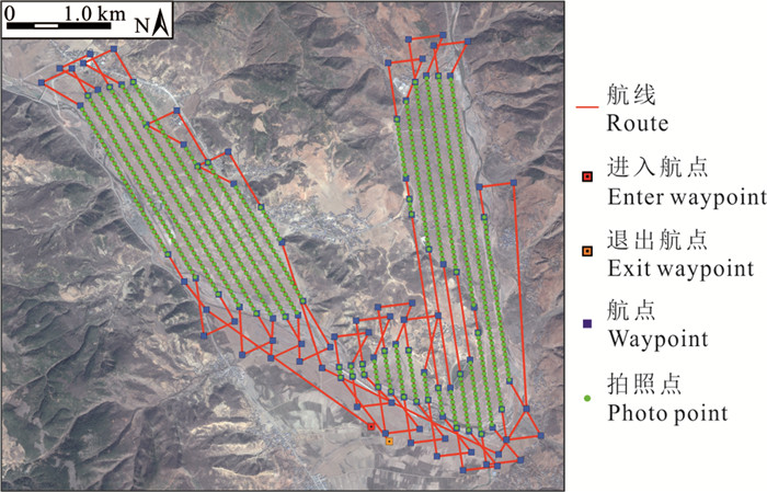
Figure 2.
Flight route map
-
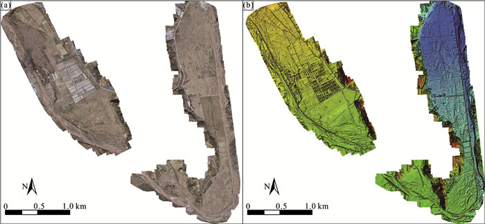
Figure 3.
Digital orthophoto map and digital surface model
-
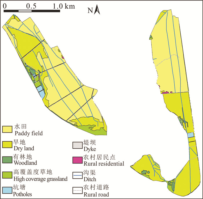
Figure 4.
Current status of land use
-
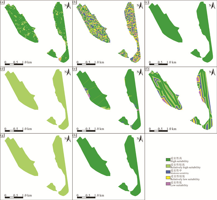
Figure 5.
Single factor chart of land suitability evaluation
-
Figure 6.
Land suitability evaluation map