
| China Geological Survey Chinese Academy of Geological Sciences | Host |
| 科学出版社 | Publish |

| Citation: |
YANG Qiang, YE Zhennan, GAO Youlong, LI Qiang, DING Weicui. 2018. Dataset of the 2015 Geo-Hazard Survey of the Yanzi River Basin, Upstream of the Jialing River[J]. Geology in China, 45(S2): 47-55. doi: 10.12029/gc2018Z206

|
Dataset of the 2015 Geo-Hazard Survey of the Yanzi River Basin, Upstream of the Jialing River
-
Abstract
This dataset is prepared based on the data and information obtained from the survey of collapse, landslide, debris flow and engineering geology within the Yanzi River Basin, upstream of the Jialing River, in accordance with the unified standards and requirements of China Geological Survey (CGS). The data were acquired by remote sensing interpretation and surface survey as well as 3D laser scanning, low altitude aerial photography using UAV, and comprehensive geophysical exploration. The dataset contains 223 sets of landslide data, 170 sets of collapse data, 44 sets of debris flow data and 129 sets of data from specific geological engineering survey. The dataset covers the following information within the Yanzi River Basin:the basic attributes of geological hazards such as collapse, landslide and debris flow; geological environment background, development characteristics and distribution of the hazards; and engineering geological conditions inducing hazards. To guarantee the truth, accuracy and credibility of the dataset, processes such as field data acquisition, data collection and verification, data storage and review and a well-developed quality control system were adopted. Thus the dataset has comprehensively increased the accuracy of geological hazard knowledge and engineering geology survey in the Yanzi River Basin, providing an effective support for the study of the formation mechanism of collapse, landslide and debris flow and the study on zoning by susceptibility, hazard, and risk of these geological hazards. Furthermore, the dataset will provide reliable basic data necessary for the prevention and control of geological hazards within the basin.
-

-
References
陈万利, 刘金辉, 杨强. 2017.燕子河流域滑坡灾害特征及稳定性分析[J].土工基础, 31(2):201-205 谭永杰. 2016.地质大数据与信息服务工程技术框架[J].地理信息世界, 23(1):1-9 doi: 10.3969/j.issn.1672-1586.2016.01.001 唐新凯, 梁收运. 2012.白龙江流域甘肃段地质灾害与经济发展的关系[J].地质灾害与环境保护, 23(4):66-71 doi: 10.3969/j.issn.1006-4362.2012.04.012 王莉霞, 娄桂霞. 2012.康县的山地灾害及防治对策[J].中国水土保持(4):58-60 doi: 10.3969/j.issn.1000-0941.2012.04.021 张小辉, 杨强, 刘金辉, 叶振南. 2017.燕子河流域崩塌地质灾害成灾机理分析[J].水土保持研究, 24(3):351-356 Chen Wanli, Liu Jinhui, Yang Qiang. 2017. Hazards Characterization and Stability Evaluation of the Yanzi River Basin Landslides[J]. Soil Eng. and Foundation, 31(2):201-205 (in Chinese with English abstract) Tang Xinkai, Liang Shouyun. 2012. Correlation Between Geo-Hazards and Economic Development for the Gansu Section of the BaiLongJiang Catchment Area[J]. Journal of Geological Hazards and Environment Preservation, 23(4):66-71 (in Chinese with English abstract) Tan Yongjie. 2016. Architecture and Key Issues of Geological Big Data and Information Service Project[J]. Geomatics World, 23(1):1-9 (in Chinese with English abstract) Wang Lixia, Lou Guixia. 2012. Mountain Disasters and Prevention Countermeasures in Kang County[J]. Soil and Water Conservation in China, (4):58-60 (in Chinese) doi: 10.3969/j.issn.1000-0941.2012.04.021 Zhang Xiaohui, Yang Qiang, Liu Jinhui, Ye Zhennan. 2017. Analysis on Disaster Mechanism of Collapse in Yanzi River Basin[J]. Research of Soil and Water Conservation, 24(3):351-356 (in Chinese with English abstract) -
Access History
Figures(12)
Tables(4)

Export File
Citation
YANG Qiang, YE Zhennan, GAO Youlong, LI Qiang, DING Weicui. 2018. Dataset of the 2015 Geo-Hazard Survey of the Yanzi River Basin, Upstream of the Jialing River[J]. Geology in China, 45(S2): 47-55. doi: 10.12029/gc2018Z206
Format
Content
 DownLoad:

- Figure 1.
- Figure 2.
- Figure 3.
- Figure 4.
- Figure 5.
- Figure 6.
-
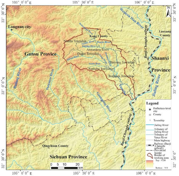
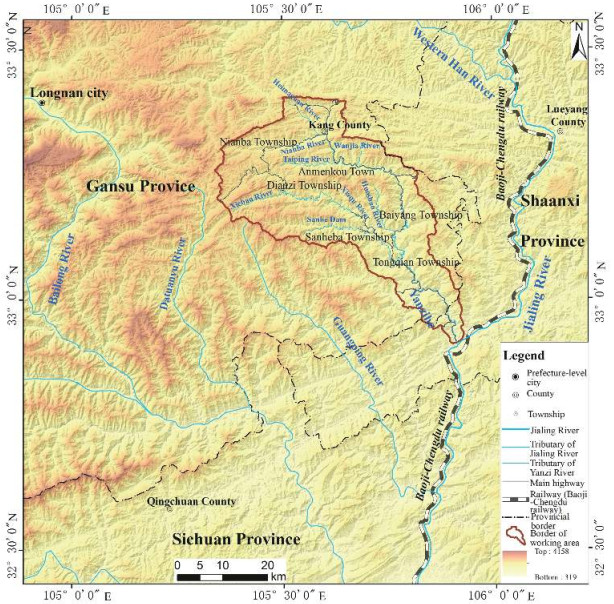
Figure 1.
Yanzi River Basin map location
-
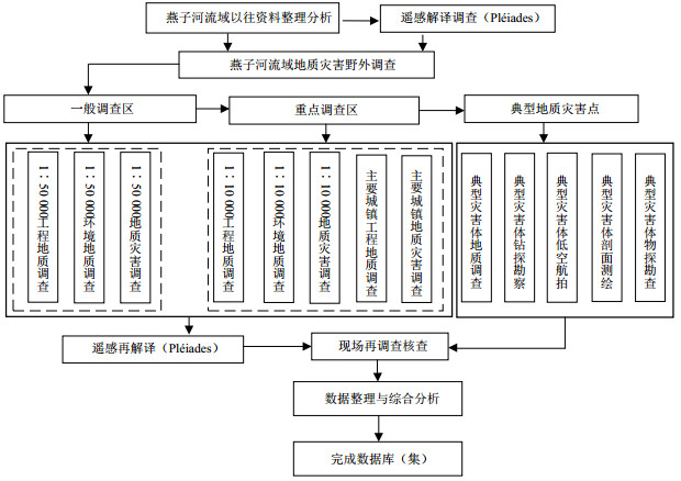
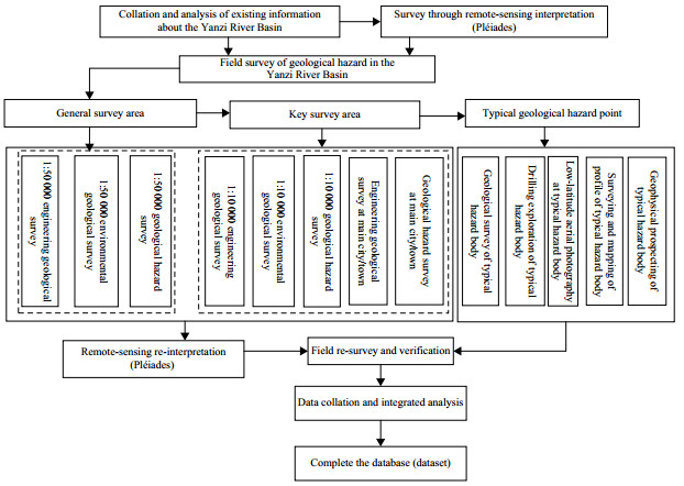
Figure 2.
Work Process
-
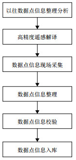
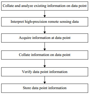
Figure 3.
Data Acquisition Process
-
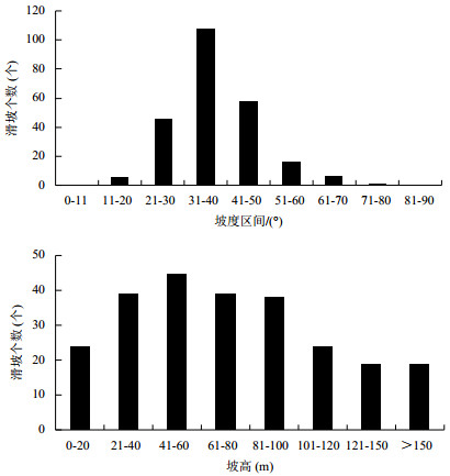
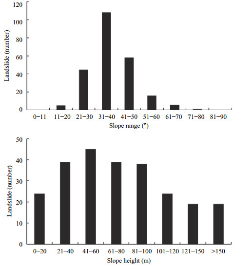
Figure 4.
Relation between landslide number and slope gradient/height
-
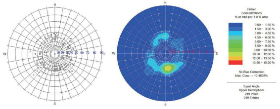
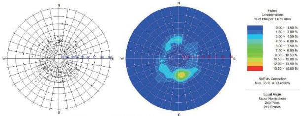
Figure 5.
Landslide Slope Direction and Slope Gradient Density
-
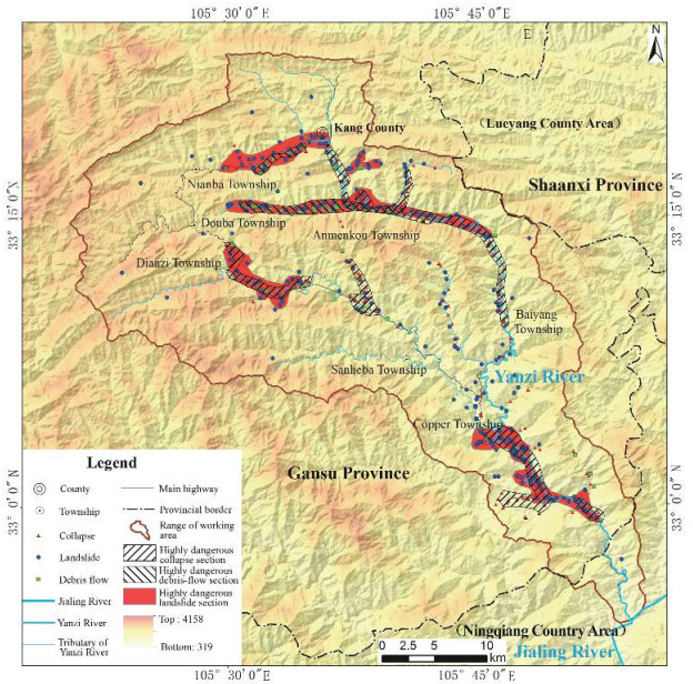
Figure 6.
Distribution of Landslide, Collapse and Debris Flow as well as Highly Dangerous Sections