
| China Geological Survey Chinese Academy of Geological Sciences | Host |
| 科学出版社 | Publish |

| Citation: |
LI Xiangquan, MA Jianfei, FU Changchang. 2018. Dataset of the 1: 50 000 Hydrogeological Map of the Huojitu Mine Area, Shendong Coal Base[J]. Geology in China, 45(S2): 13-22. doi: 10.12029/gc2018Z202

|
Dataset of the 1: 50 000 Hydrogeological Map of the Huojitu Mine Area, Shendong Coal Base
-
Abstract
For this dataset of the 1:50 000 hydrogeological map of Huojitu, multiple methods such as remote sensing, surface survey, geophysical exploration, drilling exploration as well as hydrochemical isotope tests were applied for data acquisition. The remotely sensed data interpretation of 800 km2 area was successfully achieved in two phases, together with 377 surface survey points, 240 points of simultaneous-measurement of groundwater level during rain and dry seasons, 10 sets of pumping tests, 127 sets of water samples and 600 m of cumulative hydrogeological drilling footage. The level of water yield property of the Quaternary porous aquifer and the Cretaceous Luohe Formation porous fissure aquifer within the working area was refined in this dataset, filling the gap in hydrogeological information about the Jurassic Anding Formation and Zhiluo Formation. Meanwhile, secondary environmental geologic elements related to coal mining were added, and the unwatering zone of the shallow aquifer was successfully delineated for the first time. Furthermore, a groundwater circulation mode under the impact of coal mining was established, highlighting characteristics of hydrogeological survey in mine areas. This dataset provides normal support to plan, deploy and summarize hydrogeological survey in the mine areas, which is really important to guarantee national security in both energy resources and ecology.
-
Keywords:
- hydrogeological mapping /
- new dataset /
- 1:50 000 /
- unwatering zone /
- Shendong Coal Base
-

-
References
曹志国, 何瑞敏, 王兴峰. 2014.地下水受煤炭开采的影响及其储存利用技术[J].煤炭科学技术, 42(12):113-116 党犇, 赵虹, 李文厚, 陈永胜, 郑小杰, 燕州泉, 贾玉琴. 2007.鄂尔多斯盆地陕北地区上三叠统延长组不同级次层序界面的识别[J].中国地质, 34(3):414-421 doi: 10.3969/j.issn.1000-3657.2007.03.007 段中会. 2001.榆神府矿区环境地质问题及开发效应[J].陕西煤炭(2):1-3 doi: 10.3969/j.issn.1671-749X.2001.02.001 DZ/T0282-2015, 中华人民共和国水文地质调查规范(1: 50 000)[S]. 2015. GB/T 14848-2017, 地下水质量标准[S]. 2017. MTT1091-2008, 煤矿床水文地质、工程地质及环境地质勘察评价标准[S]. 2008. 王振荣. 2017.神东矿区矿井水文地质类型划分标准研究[J].煤矿安全, 47(S1) 徐友宁, 李智佩, 陈社斌, 陈华清, 袁汉春. 2008.大柳塔煤矿采煤塌陷对土地沙漠化进程的影响[J].中国地质, 35(1):161-166 袁建飞, 邓国仕, 徐芬, 唐业旗, 李鹏岳. 2016.毕节市北部岩溶地下水水化学特征及影响因素的多元统计分析[J].中国地质, 43(4):1446-1456 张茂省, 董英, 杜荣军, 顾小凡. 2010.陕北能源化工基地采煤对地下水资源的影响及对策[J].地学前缘, 17(6):235-246 Cao Zhiguo, He Ruimin, Wang Xingfeng. 2014. Coal Mining Affected to Underground Water and Underground Water Storage and Utilization Technology[J]. Coal Science and Technology, 42(12):113-116 (in Chinese with English abstract) Dang Ben, Zhao Hong, Li Wenhou, Chen Yongsheng, Zheng Xiaojie, Yan Zhouquan, Jia Yuqin. 2007. Identification of sequence boundaries of different orders in the Upper Triassic Yanchang Formation in northern Shaanxi, Ordos basin[J]. Geology in China, 34(3):414-421 (in Chinese with English abstract) Duan Zhonghui. 2001. Environmental geological problems and development effects in Yushenfu mining area[J]. Shaanxi Coal, 2001(2):1-3 (in Chinese) DZ/T0282-2015, Hydrogeological survey specification (1: 50 000)[S]. 2015 (in Chinese). GB/T 14848-2017, The standard of Groundwater quality[S]. 2017 (in Chinese). MTT1091-2008, Coal mine hydrogeology, engineering geology and environmental geological survey evaluation criteria[S].2008 (in Chinese). Wang Zhenrong. 2017. Study on Coal Mine Hydrogeological Classification Standards in Shendong Mining Area[J]. Safety in Coal Mines, 47(S1):86-89 (in Chinese with English abstract) Xu Youning, Li Zhipei, Chen Shebin, Chen Huaqing, Yuan Hanchun. 2008. Effect of coal mining collapses of the Daliuta coal mine on land desertification[J]. Geology in China, 35(1):161-166 (in Chinese with English abstract) Yuan Jianfei, Deng Guoshi, Xu Fen, Tang Yeqi, Li Pengyue. 2016. The multivariate statistical analysis of chemical characteristics and influencing factors of karst groundwater in the northern part of Bijie City, Guizhou Province[J]. Geology in China, 43(4):1446-1456 (in Chinese with English abstract) Zhang Maosheng, Dong Ying, Du Rongjun, Gu Xiaofan. 2010. The strategy and influence of coal mining on the groundwater resources at the energy and chemical base in the north of Shaanxi[J]. Earth Science Frontiers, 17(6):235-246 (in Chinese with English abstract) -
Access History

Figures(4)
Tables(14)

Export File
Citation
LI Xiangquan, MA Jianfei, FU Changchang. 2018. Dataset of the 1: 50 000 Hydrogeological Map of the Huojitu Mine Area, Shendong Coal Base[J]. Geology in China, 45(S2): 13-22. doi: 10.12029/gc2018Z202
Format
Content
 DownLoad:


- Figure 1.
- Figure 2.
-
Figure 1.
Distribution map of coal bases in China
-
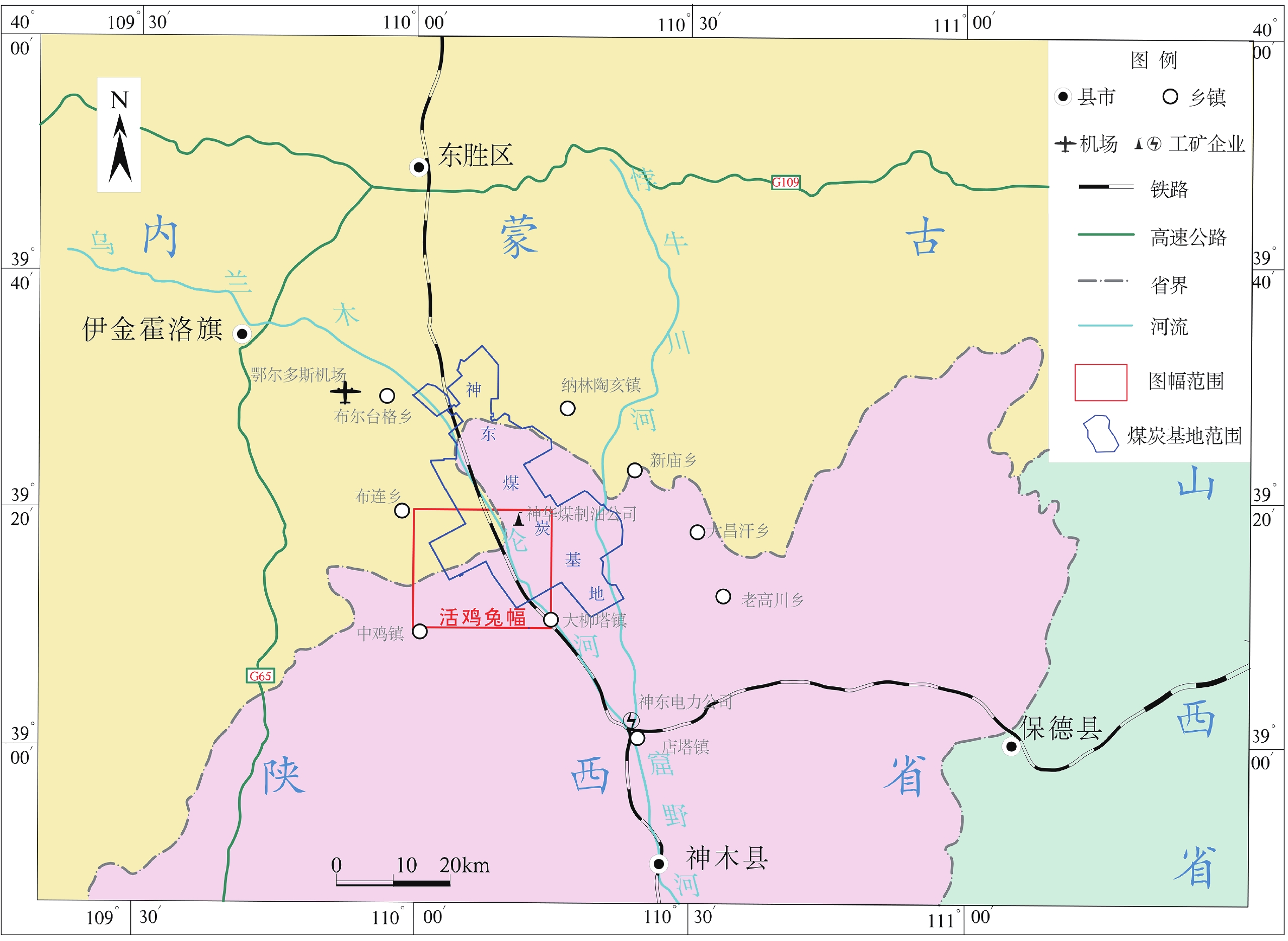
Figure 2.
Huojitu location map