
| Professional Committee of Rock and Mineral Testing Technology of the Geological Society of China, National Geological Experiment and Testing Center | Host |
| Citation: |
LIU Zhan-qing, LIU Shan-bao, CHEN Yu-chuan, WANG Cheng-hui, WAN Hao-zhang, CHEN Guo-hua, LI Sai-sai, LIANG Li-jie. LA-ICP-MS Zircon U-Pb Isotopic Dating of Lamprophyre Located Zhuxi Copper-Tungsten Mine of Jiangxi Province and Its Geological Significance[J]. Rock and Mineral Analysis, 2014, 33(5): 758-766.

|
LA-ICP-MS Zircon U-Pb Isotopic Dating of Lamprophyre Located Zhuxi Copper-Tungsten Mine of Jiangxi Province and Its Geological Significance
-
Abstract
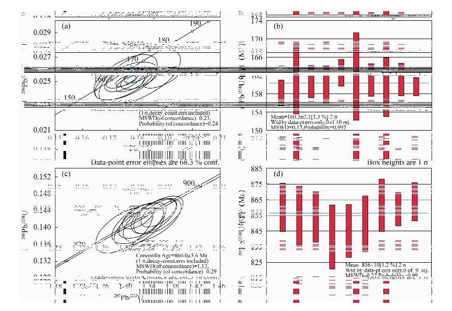
Accompanied by the crucial breakthrough of prospecting for skarn-type Cu-W deposit in Zhuxi of Jiangxi Province, the previously established model of ore distribution was incorrect in that the W and Cu deposits distribution was in the south and north regions respectively. A new model is presented, indicating that the south W deposit might occur in the north region. To verify the new hypothesis, the crystallizing ages and tectonic attributes of ore-related igneous rocks become a critical issue. Furthermore, there are several lamprophyre veins in the study area that might have some temporal and spatial relationships to the Cu-W deposit. Consequently, after extensive field surveying, core logging recording and thin section observation, the veins were dated accurately by zircon U-Pb isotopic method of LA-ICP-MS. Two groups of 206Pb/238U weighted ages of crystallization were yielded, one being (856 ± 10) Ma (MSWD=0.22), and the other is (160.3 ± 2.1) Ma (MSWD=0.17). Considering overall proofs, it is suggested here that the former group of age might represents a magmatism event during the period of subduction for South China ancient oceanic crust in early Neoproterozoic and of collision between the Yangtze and the Cathaysia continental blocks, while the latter one might indicate a magma intrusion event in the early period of Late Jurassic, which produced re-melting of previous rocks triggered by subduction from the Pacific to the Eura-asia plates in Early Jurassic, in accordance with the metallogenic age of the Taqian-Fuchun metallogenic belt in Zhuxi area. The lamprophyre geochronological study in the paper provides a sound theory basis for the metallogenesis of Zhuxi Cu-W deposits.
-
Keywords:
- Zhuxi of Jiangxi Province /
- copper-tungsten mine /
- Lamprophyre /
- zircon U-Pb dating
-

-
References
[1] [2] [3] [4] [5] [6] [7] [8] [9] [10] [11] [12] [13] [14] [15] [16] [17] [18] 塔前—朱溪1: 50000区域地质矿产调查报告[R]. 江西省地质矿产开发局九一六大队, 1981: 8. [19] [20] [21] [22] [23] [24] [25] [26] [27] [28] [29] [30] [31] [32] [33] [34] 冯宇. 呼伦贝尔草原生态红线区划定的方法研究[D]. 北京: 中国环境科学研究院, 2013. -
Access History
Figures(5)

Export File
Citation
LIU Zhan-qing, LIU Shan-bao, CHEN Yu-chuan, WANG Cheng-hui, WAN Hao-zhang, CHEN Guo-hua, LI Sai-sai, LIANG Li-jie. LA-ICP-MS Zircon U-Pb Isotopic Dating of Lamprophyre Located Zhuxi Copper-Tungsten Mine of Jiangxi Province and Its Geological Significance[J]. Rock and Mineral Analysis, 2014, 33(5): 758-766.
Format
Content
 DownLoad:
-
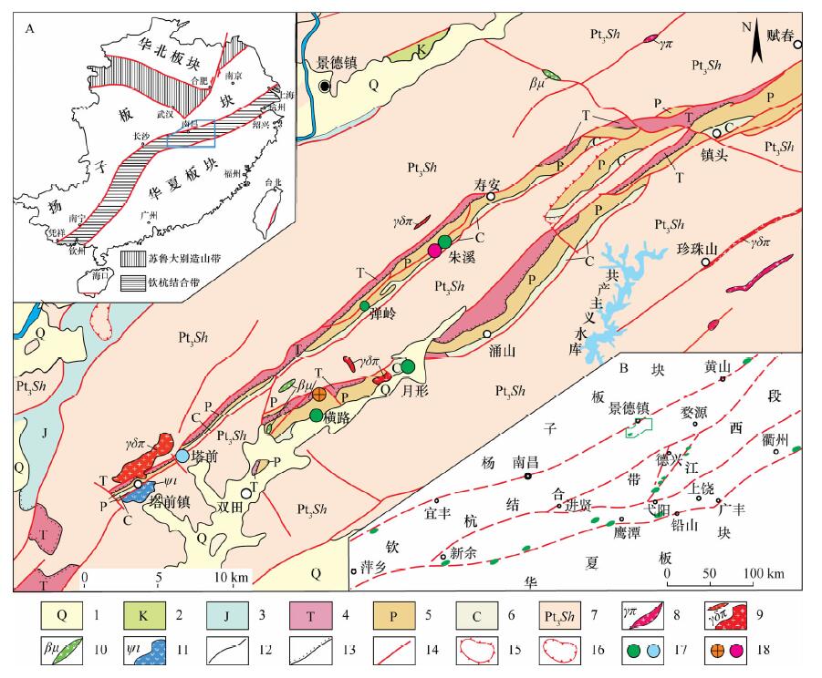
Figure 1.
Sketch map of the regional geological background (according to 1:50000 geological map of the Taqian-Fuchun metallogenic belt, 1991)
-
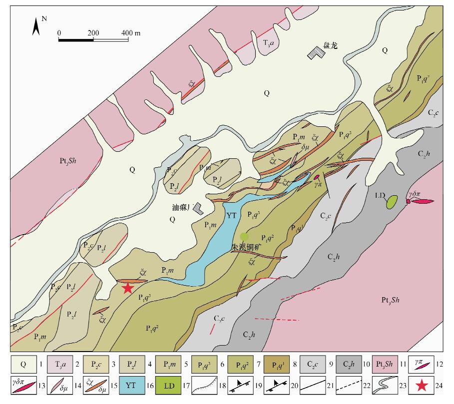
Figure 2.
Geological map of Zhuxi copper-tungsten mine
-
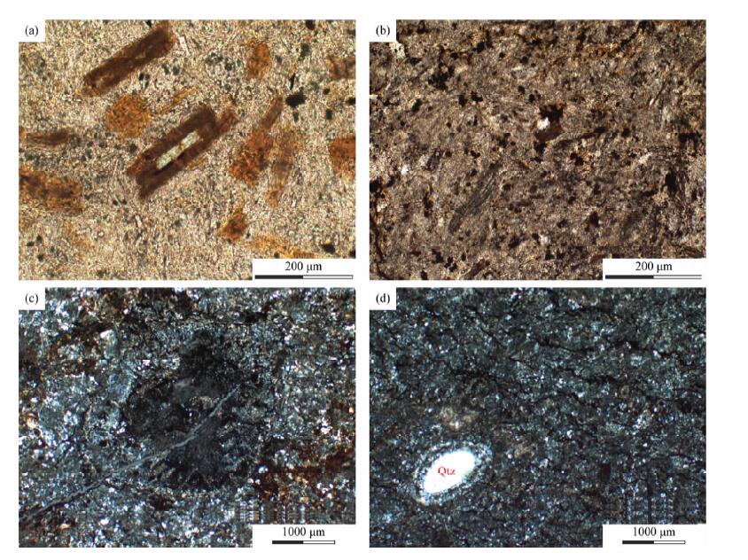
Figure 3.
Microscope characteristics of lamprophyre rock
-
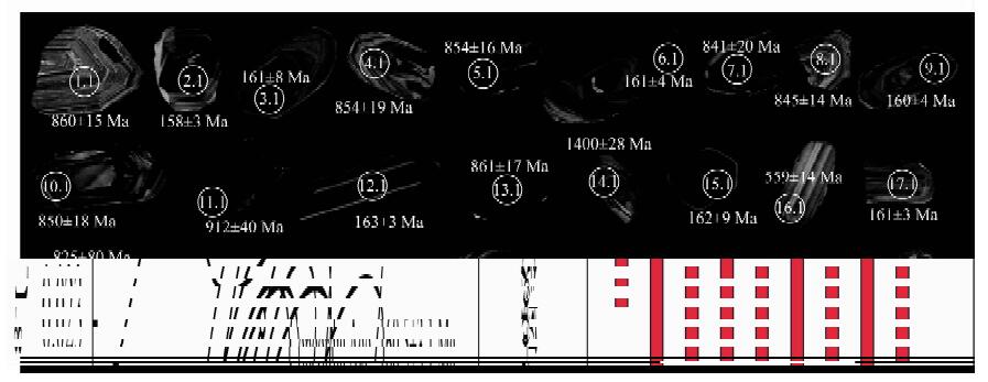
Figure 4.
Cathodoluminescence images and ages of analyzed zircons from the lamprophyre of Zhuxi copper-tungsten mine
-
Figure 5.
LA-ICP-MS zircon U-Pb concordia diagrams and histogrames of lamprophyre of Zhuxi copper-tungsten mine